3 PowerPoint presentations - primary, secondary and tertiary economic activities. Each PPT has the same design and layout- easy to read and follow. Comic sans font used to facilitate students with dyslexia. Each PPT contains images, maps and 'to do' slides with exam questions. Some slides direct students to questions in their text book but this can easily be adapted to suit the class.
Each PPT also available individually in my shop.
A 26 slide PPT (19 slides of notes, exam questions at the end of PPT) which introduces Aerial Photographs to geography students. Differentiates between vertical and high/low oblique aerial photographs, using examples. Also explains how to locate features on a aerial photo using correct terminology e.g. foreground, middleground, background.
For more PPTs on Aerial photographs and a great value bundle, see 'My Shop'.
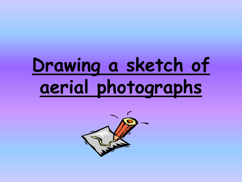
A short and simple PPT (8 slides) which explains how to sketch an aerial photograph.
To buy this resource as part of an aerial photograph bundle, see 'My shop'.
9 PPTs and a word doc activity. All based on OS maps. This is everything I cover with 1st year students (Year 7).
A 13 slide PPT introducing OS maps, scale, the legend etc…
A word document ‘Cops and Robbers’ Activity to get students using the legend
A 16 slide PPT on measuring distance (Straight line & Curved Line). Include 2 YouTube links to online demonstrations.
A 9 slide PPT on 4 figure grid references
An 8 slide PPT on 6 figure grid references
A 10 slide PPT on height on an OS map (colour, contour lines, sport heights, triangulation pillar)
An 11 slide PPT on slope on an OS map (even slope, concave slope, convex slope)
A 5 slide PPT on direction (N, S, E, W)
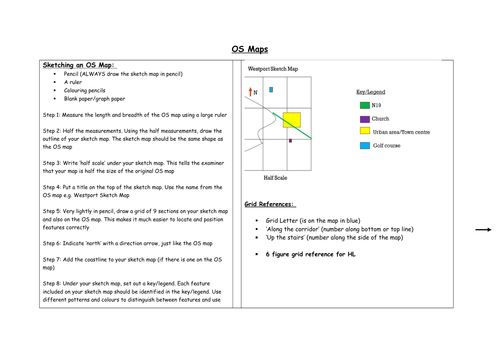
A 13 slide PPT on sketching an OS map (Manageable, step-by-step guide with visual aids)
An 8 slide PPT on reading the landscape on an OS map (relief, drainage and human landscape)
Each PPT is colourful and well-laid out with transitions and animations already done. Lots of images & extracts of OS maps used as visual aids. Some PPTs contain ‘to do’ and ‘homework’ slides. These refer to the EDCO book ‘Geoplanet’ but can be changed to suit the book you use in your own class.
*For More Geography resources and similar PPTs, see ‘My Shop’ .
A 2 page word document revision hand out which summarizes global warming and the greenhouse effect. Includes key terms, reasons for and solutions to global warming, diagrams and a sample answer on how human activity causes global warming and what impact this might have on a country.
Well laid out in a grid and easy to read and follow. Can be used for initial teaching or can be given out as a revision resource close to exams.
For a detailed PPT on this topic or lots more revision handouts, see ‘My Shop’.
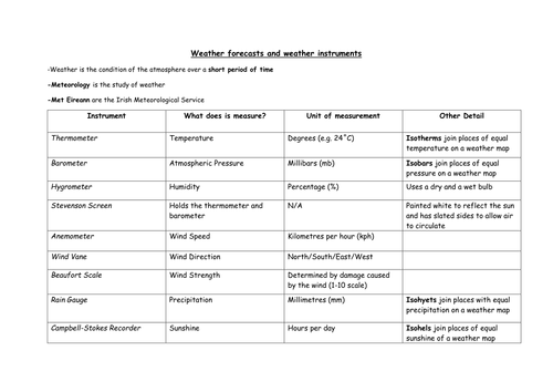
A 2 page word document which summarizes the different weather instruments and what they are used to measure. Well laid out in a grid so it is very easy for students to follow.
Can be used for initial teaching or can be given before exam as a revision resource.
For more revision hand outs or a detailed PPT on this topic, see 'My shop'
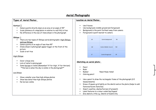
A clear and comprehension revision handout based on Aerial Photographs (aimed at Junior Cert Curriculum in Ireland).
The topic is summarized over 3 A4 pages - including headings such as sketching an aerial photo, location on an aerial photo, traffic management on an aerial photo etc...
For more revision hand outs like this, see 'My Shop'.
A clear and easy to follow 3 page revision hand out on 'OS maps'. Entire topic is summarized under headings like 'Sketching an OS map', 'settlement on an OS map', 'grid references' etc...
Aimed at Junior Cert Geography Curriculum in Ireland. Suitable for both junior and senior students but may need to be adapted for senior students.
For more geography revision notes like this, see 'my shop'.
3 resources covering secondary economic activities.
A detailed PPT with images, transitions / animations and 'to do' slides directing students to exam questions/questions from textbook. Uses Intel and RUSAL Aughinish as Irish case studies (Irish Curriculum).
Second resource is in a PPT format and is a revision quiz which can be used as a class activity or could be printed to make a worksheet.
Final resource is a 2 page word document which summarizes the topic and can be distributed to students after the topic or in their final year as revision notes.
A 3 page word document which summarizes 'rivers'. Includes key terms such as meander and river basin, gives an overview of the different stages of the river, briefly explains the different features of erosion and deposition and uses a waterfall and a meanders/ox-bow lakes as two long question examples.
Very useful for revision but can also be used to teach the topic initially.
*For lots more revision notes, see 'My Shop'*
Four PPTs on weathering...
1. An introduction to denudation and weathering as one process of denudation
2. A PPT on mechanical weathering (freeze-thaw action) including a simple animation, easy to copy diagrams and photos
3. A PPT on chemical weathering (carbonation) with detail on surface and underground features of carbonation using The Burren (Ireland) as a case study. Includes a link to a YouTube video on the Burren and lots of coloured diagrams
4. Final PPT is on Mass Movement. Discusses landslides, mudflows and soil creep. Has two links to YouTube clips which show landslides and lahars occurring
Each PPT is well laid-out and easy to follow. Key terms are highlighted/underlined. There are some 'to-do'/'homework' slides which direct the students to the text book/workbook I use (Geoplanet by EDCO) but these slides can be adapted to suit your own class/books.
*For more PPTs and revision hand outs see 'My Shop' *
A 25 question 'Haribo' quiz based on Secondary Economic Activities. Aimed at Irish Junior Cert Curriculum but most questions are universal and can easily be adapted if they don't suit. A great way to revise the chapter before an exam and also very good for assessing students' understanding/memory of the topic. I use Haribo jellies as the prize so I call it a Haribo quiz! Students love it!
7 PPTs based on ‘Settlement’ in Geography. These PPTs are all with reference to Ireland and are based on the Irish curriculum.
A 17 slide PPT on Early Settlers in Ireland
A 9 slide PPT looking at Dublin as a Primate City
A 12 slide PPT introducing rural settlement patterns (linear, dispersed & nucleated)
A 16 slide PPT on Polders (The Zuyder Zee project in Holland- includes a link to YouTube clip)
A 28 slide PPT on functions of a nucleated settlements (using Limerick & Cologne as case studies)
A 10 slide PPT looking at how functions in a settlement can change over time (using Navan as a case study)
A 9 slide PPT on the Irish Road Network
All PPTs are colourful, well-laid out and easy to read. Loots of images/photos used as visual aids. Some PPTs contain ‘to do’ or ‘homework’ slides which can be adapted to suit the text book or work book you use in your own class.
Some of these PPTs are available individually in ‘My Shop’ . This group of resources is intended to be a complete unit of work and to save you money!
An 18 slide PPT on Earthquakes- suitable for junior students/1st years. Includes images, keywords and video clips. There are some ‘to do’ and ‘homework’ slides which refer to our textbook and workbook (Geography in Action), but these can be adapted to suit your own book.
Also attached is a short visualisation.
For more PPTs on plate tectonics and for a bundle including this PPT, see ‘My Shop’.
Three PPTs - The water cycle, clouds and rain. Each PPT is bright and colorful with plenty of images and the key terms are underlined. There are links to animations and 'The Water Cycle' song in the water cycle PPT. There are also homework/activity slides. These link to the Irish geography book 'New Geo' by Edco but of course can be changed or deleted.
Also included is a cloze test which recaps on the topic and can be used as a form of assessment or as homework.
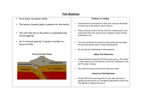
A one page word document which summarizes the formation of fold mountains. Also explains evidence of folding and briefly touches on young and old fold mountains. Includes a very simple diagram to supplement the description of their formation.
For similar hand outs on Plate Tectonics, Volcanoes and Earthquakes see my 'Shop' where you can buy these all together in a bundle.
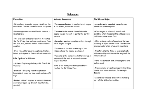
A two page word document which summarizes volcanoes, mid-ocean ridges, the Pacific ring of fire & the life cycle of a volcano. Includes all the key terms associated with volcanoes and has a labeled diagram. Also briefly touches on the pros and cons of volcanic eruptions. I made this to revise the topic with my 3rd years.
For similar hand outs on Plate tectonics, earthquakes and fold mountains, see my 'Shop' where you can buy these in a bundle.
A 14 slide PPT based on the Boreal climate. Discusses the temperature and precipitation in the boreal regions and explains how vegetation and animals adapt in this cold climate. Contains pictures, animations and transitions. The last slide is a 'to do' slide which directs the students to questions in their text book. This can be amended to suit your class.
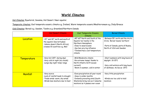
A 3 page word document which summarizes world climates with particular reference to hot desert climate, cool temperature oceanic climate and boreal climate. All information is presented in a comprehensive and easy to follow grid/graphic organizer. Also lists and gives a sample answer based on factors which influence climate.
For full PPTs on each of the climate case studies notes above please see my 'shop'.
4 PowerPoint Presentations which explain hot desert climate, cool temperate oceanic climate, boreal climate and factors affecting climates.
Also included is a graphic organizer (word document) which summarizes all the above topics and can be used as a revision handout.