Thank you for visiting! Here you will find a selection of printable, interactive worksheets for your classroom: Basic Geography worksheets with simple maps, ESL, Spanish, Bible, Reading Comprehension and more. I hope you find the resources useful! Reviews are welcome and very much appreciated. Thank you so much.
Thank you for visiting! Here you will find a selection of printable, interactive worksheets for your classroom: Basic Geography worksheets with simple maps, ESL, Spanish, Bible, Reading Comprehension and more. I hope you find the resources useful! Reviews are welcome and very much appreciated. Thank you so much.
Introduce your learners to AUSTRIA with two worksheets (plus answer key). Your students will read a brief introduction to Austria (location, capital, flag, language), write ‘Vienna’ next to the star on the map to show the location of the capital, color the small map and flag, and use the map and compass to answer 7 questions on page 2. Colored pencils and a pen or pencil are needed for this activity. No other prep needed. Basic Geography worksheet with a simple map to introduce Austria and practice cardinal and ordinal directions.
For use with Interactive Notebooks: After the worksheets are completed, students can cut out the map and flag and paste into the notebook under the topic of Europe / Sub-topic: Austria. Under the map, students can write a summary in their own words of what they now know about Austria. Collect worksheets for other countries of Europe to add to the notebook! All available in this store! Please browse this store for a selection of printable Geography worksheets for other countries of Europe (and beyond!).
Thank you for using my Geography worksheets in your classroom! I hope you find them useful. Reviews are welcome and very much appreciated!
German
Introduce your learners to Finland with two worksheets (plus answer key). Your students will read a brief introduction to Finland (location, capital, flag, language), write 'Helsinki' next to the star on the map to show the location of the capital, color the map, and use the map and compass to answer 6 questions on page 2. Colored pencils and a pen or pencil are needed for this activity. No other prep needed. Basic Geography worksheet with a simple map to introduce Finland and practice cardinal and ordinal directions.
For use with Interactive Notebooks: After completing the worksheets, students can cut out the map and flag and paste it into the notebook under the topic of Europe / Sub-Topic: Finland. Under the map and flag, students can write a summary in their own words of what they now know about Finland. Collect worksheets for other countries of Europe to add to the notebook! Please browse this store for worksheets for other countries of Europe (and beyond!)
Thank you so much for using my worksheets in your classroom!
Introduce your students to Hungary with two worksheets (plus answer key). Your students will read a brief introduction to Hungary (location, capital, flag, language), write 'Budapest' next to the star on the map to show the location of the capital, color the small map and flag, and use the map and compass to answer 9 questions on page 2. Colored pencils and a pen or pencil are needed for this activity. No other prep needed. Basic Geography worksheet with a simple map to introduce Hungary and practice cardinal and ordinal directions.
For use with Interactive Notebooks: After completing the worksheets, students can cut out the map and flag and paste it into the notebook under the topic of Europe / Sub-Topic: Hungary. Under the map and flag, students can write a summary in their own words of what they now know about this country. Collect worksheets for other countries of Europe to add to the notebook! Please browse this store for a selection of worksheets for other countries of Europe (and beyond!).
Thank you so much for using my Geography worksheets in your classroom! Reviews are welcome and very much appreciated.
Introduce your students to the country of Paraguay in South America with this printable handout of two worksheets (plus answer key). Your students will read a brief introduction to Paraguay (location, capital, flag, language), write 'Asunción' next to the star on the map to show the location of the capital, color the map and flag, and use the map and compass to answer 6 questions on page 2. Colored pencils and a pen or pencil are needed for this activity. No other prep needed. Basic Geography worksheet with a simple map to introduce the country of Paraguay and practice cardinal and ordinal directions.
For use with Interactive Notebooks: After the worksheets for Paraguay are completed, students can cut out the map and flag and paste into the notebook under the topic of South America/Sub-Topic: Paraguay. Under the map, students can write a summary in their own words of what they now know about this country. Please browse this store for a selection of worksheets for other countries of South America (and beyond!)
Thank you so much for using my Geography worksheets in your classroom! Reviews are welcome and very much appreciated!
Introduce your students to Uruguay with this printable handout of two worksheets (plus answer key). Your students will read a brief overview of Uruguay (location, capital, language, flag), write 'Montevideo' next to the star on the map to show the capital, color the small map and flag, and use the map and compass to answer 7 questions. Basic Geography worksheet with a simple map to introduce Uruguay and practice cardinal and ordinal directions.
For use with Interactive Notebooks: After the handout is completed, students can cut out the map and flag and paste into the notebook under the topic of South America/Sub-Topic: Uruguay. Under the map, your students will write a summary in their own words of what they now know about this country. Collect handouts for other countries of South America to add to the notebook! Please browse this store for a selection of printable Geography worksheets for other countries of South America (and beyond!).
Thank you so much for using my Geography worksheets in your classroom! I hope you find them useful. Reviews are welcome and very much appreciated. Please follow this store for more printables.
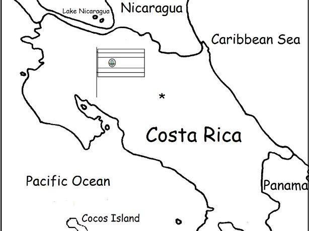
Introduce your students to Costa Rica with two worksheets (plus answer key). Your students will read a brief introduction to Costa Rica (location, capital, language, flag), write 'San José' next to the star on the map to show the location of the capital, color the small flag and map, and use the map and compass to answer 6 questions on page 2. Colored pencils and a pen or pencil are needed for this activity. No other prep needed. Basic Geography worksheet with a simple map to introduce Costa Rica and practice cardinal and ordinal directions.
For use with Interactive Notebooks: After the worksheets are completed, students can cut out the map and flag and paste into the notebook under the topic of Central America (or Spanish-Speaking Countries) /Sub-Topic: Costa Rica. Under the map and flag, students can write a summary in their own words of what they now know about this country. Collect worksheets for other countries of Central America (or Spanish-Speaking Countries) to add to the notebook! Worksheets for all countries available in this store! Please browse this store for a selection of printable Geography worksheets for other countries of Central America and beyond!
Thank you so much for using my Geography worksheets in your classroom! I hope you find them useful. Reviews are welcome and very much appreciated! Please browse this store for a selection of worksheets to introduce your learners to the countries of the world!
Introduce your students to French Guiana with this printable handout of 2 worksheets (plus answer key). Your students will read a brief overview of French Guiana (location, capital, language, flag), write 'Cayenne' next to the star on the map to show the capital, color a small map and flag, and use the map and compass to answer 6 questions. Basic Geography worksheet with a simple map to introduce French Guiana and practice cardinal and ordinal directions.
For use with Interactive Notebooks: After the handout is completed, students can cut out the map and flag and paste into the notebook under the topic South America/Sub-Topic: French Guiana. Under the map, your students can write a summary in their own words of what they now know about French Guiana. Collect handouts for other countries of South America to add to the notebook. Please browse this store for a selection of printable handouts of other countries of South America (and beyond!).
Thank you so much for using my Geography worksheets in your classroom! Reviews are welcome and very much appreciated.
Introduce your students to Honduras with this printable handout of two worksheets (plus answer key). Your students will read a brief introduction to Honduras (location, capital, flag, language), write 'Tegucigalpa' next to the star on the map to show the capital, color a small map and flag, and use the map and compass to answer 6 questions on page 2. Colored pencils and a pen or pencil are needed for this activity. No other prep needed. Basic Geography worksheet with a simple map to introduce Honduras and practice cardinal and ordinal directions.
For use with Interactive Notebooks: After the worksheets are completed, students can cut out the map and flag and paste into the notebook under the topic of Central America/Sub-Topic: Honduras. Under the map, your students can write a summary in their own words of what they now know about this country. Collect worksheets for all countries of Central America to add to the notebook! Please browse this store for a selection of printable handouts for other countries of Central America (and beyond!).
Thank you so much for using my Geography worksheets in your classroom! I hope you find them useful. Reviews are welcome and very much appreciated!
Introduce your students to El Salvador with two printable worksheets (plus answer key). Your students will read a brief introduction to El Salvador (location, capital, flag, language), write 'San Salvador' next to the star on the map to show the capital, color the small map and flag, and use the map and compass to answer 7 questions on page 2. Colored pencils and a pen or pencil needed for this activity. No other prep needed. Basic Geography worksheet with a simple map to introduce El Salvador and practice cardinal and ordinal directions.
For use with Interactive Notebooks: After the worksheets are completed, students can cut out the map and flag and paste into the notebook under the topic of Central America (or Spanish-Speaking Countries)/Sub-topic: El Salvador. Under the map and flag, students can write a summary in their own words about what they now know about this country. Collect worksheets for other countries of Central America (or Spanish-speaking countries) to add to the notebook! All available in this store! Please browse this store for a selection of worksheets for countries of Central America (and beyond!).
Thank you so much for using my Geography worksheets in your classroom! I hope you find them useful. Reviews are welcome and very much appreciated!
Introduce your students to Central America one country at a time with a worksheet for each country!
Every country of Central America includes a printable handout of 2 pages (plus answer key). Page 1: Read a brief introduction to the country (location, capital, flag, language), write the capital next to the star on the map, color the small map and flag. Page 2: Use the map and compass to answer questions and identify locations of surrounding countries.
For use with Interactive Notebooks: After the worksheets for a country are completed, students cut out the map and flag and paste into the notebook under the topic of Central America. Under the map and flag, students can write a summary of what they now know about that country. Add a country until all of Central America is complete!
Worksheets also included in this bundle:
-Fill in the Blanks on the Map of Central America. Cut and paste into notebook.
-Cut out each flag and paste into the map of Central America.
Thank you so much for using my worksheets in your classroom! I hope you find them useful. Reviews are welcome and very much appreciated!
Introduce your learners to Margaret Hamilton, the actress who played the Wicked Witch of the Wizard of Oz, with this 340 word mini-bio! 4 printable worksheets include 4 photos, 10 vocabulary words, and 5 ‘True or False’ questions for reading comprehension and vocabulary building.
Vocabulary words include: despised, frightened, talented, concerned, fictional, frustrated, polar, opposite, portrayed, promoted. Students will write the definition of each word based on context.
Thank you so much for using my workheets in your classroom! I hope you find them useful. Reviews are welcome and very much appreciated! Please browse this store for more worksheets to use in your classroom!
Introduce your students to Guyana with this printable handout of two worksheets (plus answer key). Your students will read a brief overview of Guyana (location, capital, flag, language), write 'Georgetown' next to the star on the map to show the capital, color the small map and flag, and use the map and compass to answer 6 questions. Colored pencils and a pen or pencil are needed for this activity. No other prep needed. Basic Geography worksheet with a simple map to introduce Guyana and practice cardinal and ordinal directions.
For use with Interactive Notebooks: After the handout is completed, students can cut out the map and paste into the notebook under the topic of South America/Sub-Topic: Guyana. Under the map, your students will write a summary in their own words of what they now know about this country. Collect handouts for other countries of South America to add to the notebook! Please browse this store for a selection of printable handouts for other countries of South America (and beyond!).
This activity is usually done in class but can also be assigned as homework.
Thank you so much for using my Geography worksheets in your classroom!
This packet includes a worksheet for each chapter of ‘Tales of a Fourth Grade Nothing’ by Judy Blume. After reading each chapter, readers can complete the worksheet/s for that chapter. Includes word search puzzles, fill-in-the-blanks, matching activities, sequencing and crosswords for reading comprehension and vocabulary building. 17 pages. Answer Key included.
Worksheets are black and white (with small pictures to color as an option).
Thank you for using this pack of worksheets! I hope you find them useful! Reviews are welcome and very much appreciated. If you are continuing with the Fudge series, printable worksheets for each chapter of Fudge-A-Mania are also available!
Thank you again.
Introduce your students to North Korea with this printable handout of 2 worksheets (plus answer key). Your students will read a brief introduction to North Korea (location, capital, flag, language), write 'Pyongyang’ next to the star on the map to show the location of the capital, write DMZ on the border of North and South Korea to show the location of the Korean Demilitarized Zone, color the small flag and map, and use the map and compass to answer 9 questions on page 2. Colored pencils and a pen or pencil are needed for this activity. No other prep needed. Basic Geography worksheet with a simple map to introduce North Korea.
For use with Interactive Notebooks: After the worksheets are completed, students can cut out the map and flag and paste into the notebook under the topic of Asia/Sub-Topic: North Korea. Under the map, students can write a summary in their own words of what they now know about North Korea. Collect handouts for other countries of Asia to add to the notebook! Please browse this store for a selection of printable handouts for other countries of Asia (and beyond!).
Thank you so much for using my Geography worksheets in your classroom! I hope you find them useful. Reviews are welcome and very much appreciated! Please browse this store for worksheets with simple maps to introduce your learners to the countries of the world!
Introduce your students to IRAQ with this printable handout of two worksheets (plus answer key). Your students will read a brief introduction to Iraq (location, capital, flag, language), write ‘Baghdad’ next to the star on the map to show the capital, color the small flag and map, and use the map and compass to answer 9 questions on page 2. Colored pencils and a pen or pencil are needed for this activity. No other prep needed. Basic Geography worksheet with a simple map to introduce Iraq and practice cardinal and ordinal directions.
For use with Interactive Notebooks: After the worksheets are completed, students can cut out the map and flag and paste into the notebook under the topic of Asia / Sub-Topic: Iraq. Under the map, students can write a summary in their own words of what they now know about this country. Collect worksheets for other countries of Asia to add to the notebook! Please browse this store for worsheets for all other countries of Asia (and beyond!).
Thank you so much for using my Geography worksheets in your classroom! I hope you find them useful. Reviews are welcome and very much appreciated!
Tigris River, Euphrates River, Cardinal, Ordinal directions.
Introduce your students to Japan with this printable handout of two worksheets (plus answer key). Your students will read a brief introductin to Japan (location, capital, flag, language), write ‘Tokyo’ next to the star on the map to show the location of the capital, color the small map and flag, and use the map and compass to answer 7 questions on page 2. Colored pencils and a pen or pencil are needed for this activity. No other prep needed. Basic Geography worksheet with a simple map to introduce Japan and practice cardinal and ordinal directions.
For use with Interactive Notebooks: After the worksheets are completed, students can cut out the map and flag and paste into the notebook under the topic of Asia / Sub-Topic: Japan. Under the map and flag, your students can write a summary in their own words of what they now know about this country. Collect handouts for other countries of Asia to add to the notebook! Please browse this store for a selection of worksheets for all other countries of Asia (and beyond!)
Thank you so much for using my Geography worksheets in your classroom! I hope you find them useful. Reviews are welcome and very much appreciated!
Japanese Archipelago, Islands of Honshu, Hokkaido, Kyushu, Shikoku.
Nisshōki, Hinomaru, Maritime borders. Dialect. Okinawa, Ryukyu Islands.
Introduce your students to the United States of America with two worksheets (plus answer key). Your students will read a brief introduction to the United States (location, capital, flag, language, 13 original colonies), write ‘Washington D.C.’ next to the star on the map to show the location of the capital, color the small map, and use the map and compass to answer 10 questions on page 2.
Please note: This map includes the United States and surrounding, including Canada, Mexico, Atlantic Ocean, Pacific Ocean, Arctic Ocean, Gulf of Mexico, Cuba, Haiti, Dominican Republic, Puerto Rico. Individual states of America are not included on this map (except for Alaska, Hawaii and 13 original colonies). For worksheets to introduce your learners to each of the 50 states of the USA, please browse this store!
For use with Interactive Notebooks: After the worksheet is completed, students can cut out the map and flag and paste into the notebook under the topic of North America/Sub-Topic: United States. Under the map and flag, students can write a summary in their own words of what they now know about the United States of America! Collect worksheets for other countries of North America to add to the notebook! Please browse this store for worksheets to introduce your learners to countries of North America, such as Canada, Mexico, Cuba, Dominican Republic, Haiti, Puerto Rico, and countries of Central America!
Thank you so much for using my Geography worksheets in your classroom! I hope you find them useful. Reviews are welcome and very much appreciated.
Included: Washington D.C. formerly District of Columbia, named after first president and Founding Father George Washington.
Introduce your learners to the US state of TEXAS with two worksheets (plus answer key). Your students will read a brief introduction to Texas (location, capital, flag, state bird and state flower), write ‘Austin’ next to the star on the map to show the location of the capital, color the small map, state bird and state flower, and use the map and compass to answer 7 questions on page 2. Colored pencils and a pen or pencil are needed for this activity. No other prep needed. Basic Geography worksheet with a simple map to introduce Texas and practice cardinal and ordinal directions.
For use with Interactive Notebooks: After the worksheets are completed, students can cut out the map, flag, state bird and state flower, and paste into the notebook under the topic of United States/Sub-Topic: Texas. Under the map, students can write a summary of what they now know about this state. Collect worksheets for all states to add to the notebook! Please browse this store for worksheets for other states of the USA (and beyond!)
Thank you so much for using my Geography worksheets in your classroom! I hope you find them useful. Reviews are welcome and very much appreciated.
State bird: Northern Mockingbird
State flower: Bluebonnet
Introduce your students to EQUATORIAL GUINEA with two worksheets (plus answer key). Your students will read a brief introduction to Equatorial Guinea (location, capital, flag, language), write ‘Malabo’ next to the star on the map to show the location of the capital, trace the dotted line to show the equator, color the small flag and map, and then use the map and compass to answer 8 questions on page 2. Pen or pencil and colored pencils needed for this activity. No other prep needed. Basic Geography worksheet with a simple map to introduce Equatorial Guinea and practice cardinal and ordinal directions.
For use with Interactive Notebooks: After the worksheets are completed, students can cut out the map and flag and paste into the notebook under the topic of Topic: Africa / Sub-Topic: Equatorial Guinea. (or Topic: Spanish-Speaking Countries / Sub-Topic: Equatorial Guinea). Under the map, your students can write a summary in their own words of what they now know about this country. Collect worksheets for other countries of Africa or Spanish-speaking countries to add to the notebook! Please browse this store for worksheets for other countries!
Thank you so much for using my Geography worksheets in your classroom! Reviews are welcome and very much appreciated.
Africa, Spanish, Gulf of Guinea, cardinal, ordinal directions.
Introduce your students to Puerto Rico with this printable handout of two worksheets (plus answer key). Your students will read a brief introduction to Puerto Rico (location, capital, flag, language), write ‘San Juan’ next to the star on the map to show the location of the capital, color the small map and flag, and use the map and compass to answer 6 questions on page 2. Colored pencils and a pen or pencil are needed for this activity. No other prep needed.
For use with Interactive Notebooks: After the worksheets are completed, students can cut out the map and flag of Puerto Rico and paste into the notebook. Under the map and flag, students can write a summary in their own words of what they now know about Puerto Rico. Collect worksheets for other countries to add to the notebook! Please browse this store for a selection of worksheets for Caribbean Islands, Spanish-speaking countries, and beyond!
Thank you so much for using my Geography worksheets in your classroom! I hope you find them useful. Reviews are welcome and very much appreciated!
Included on map of Puerto Rico and surrounding: Atlantic Ocean, Caribbean Sea, Mona, Culebra, Viequez, Desecheo, Florida, Dominican Republic, Haiti, Cuba. Cardinal, ordinal directions.