Thank you for visiting! Here you will find a selection of printable, interactive worksheets for your classroom: Basic Geography worksheets with simple maps, ESL, Spanish, Bible, Reading Comprehension and more. I hope you find the resources useful! Reviews are welcome and very much appreciated. Thank you so much.
Thank you for visiting! Here you will find a selection of printable, interactive worksheets for your classroom: Basic Geography worksheets with simple maps, ESL, Spanish, Bible, Reading Comprehension and more. I hope you find the resources useful! Reviews are welcome and very much appreciated. Thank you so much.
Introduce your learners to Hong Kong (SAR of China) in Eastern Asia with this printable handout of two worksheets (plus answer key). Your students will read a brief overview of Hong Kong (location, capital, language, flag), write 'City of Victoria (aka Central) next to the star on the map to show the location of the capital, color the small map, and use the map and compass to answer 10 True/False questions on page 2. Colored pencils and a pen or pencil are needed for this activity. No other prep needed. Basic Geography worksheet with a simple map to introduce Hong Kong and practice cardinal and ordinal directions.
For use with Interactive Notebooks: After your students complete the worksheets, they can cut out the map and flag of flag and paste into the notebook under the topic of Asia / Sub-topic: Hong Kong. Under the map, students can write a summary in their own words of what they now know about Hong Kong. Collect worksheets for all countries of Asia to add to the notebook! Please browse this store for worksheets for other countries of Asia (and beyond!)
Thank you so much for using my introductory Geography worksheets in your classroom. I appreciate it! I hope you find them useful and fun. Reviews are welcome and very much appreciated!
Included: South China Sea, New Territories, Hong Kong Island, Kowloon Peninsula, Lantau Island, Lamma Island, Cheung Island, Poi Toi Islands, Tai Mo Shan.
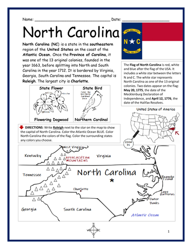
Introduce your learners to the state of North Carolina with this printable handout of two worksheets (plus answer key). Your students will read a brief overview of North Carolina (location, capital, flag, state bird, state flower), write ‘Raleigh’ next to the star on the map to show the location of the capital, color the small map, state bird and state flower, and use the map and compass to answer 10 true/false questions on page 2. Colored pencils and a pen or pencil are needed for this activity. No other prep needed. Basic Geography worksheet with a simple map to introduce the state of North Carolina and practice cardinal and ordinal directions.
For use with Interactive Notebooks: After the worksheets are completed, students can cut out the map, flag, state bird and state flower of North Carolina and paste into the notebook under the topic of United States/Sub-Topic: North Carolina. Under the map, students can write a summary in their own words of what they now know about this state. Collect worksheets for other states of the US to add to the notebook! Please browse this store for a selection of worksheets for other states of the USA (and beyond!).
Thank you so much for using my worksheets in your classroom! Reviews are welcome and very much appreciated!
Included: Province of Carolina, Virginia, Georgia, South Carolina, Tennessee, Charlotte, Appalachian Mountains, Atlantic Ocean.
Introduce your students to Ecuador in South America with this black & white printable handout of two worksheets (plus answer key). Your students will read a brief introduction to Ecuador (location, capital, flag, language), write ‘Quito’ next to the star on the map to show the location of the capital, color the map and flag, and use the map and compass to answer 7 questions on page 2. Colored pencils and a pen or pencil are needed for this activity. No other prep needed. Basic Geography worksheet with a simple map to introduce the country of Ecuador and practice cardinal and ordinal directions.
This worksheet prints in black and white - (1) For easy printing, and (2) so students can be in charge of all the coloring! For more worksheets in black in white (and color) to introduce your learners to countries of South America (and around the world!) please browse this store.
Thank you so much for using my Geography worksheets in your classroom! Reviews are welcome and very much appreciated!
Introduce your learners to French Polynesia (also referred to as Tahiti) with two worksheets (plus answer key).
Your students will read a brief introduction to French Polynesia (location, capital, flag, language, islands), locate and circle the location of French Polynesia on the map of Oceania (map 1), write ‘Papeete’ next to the star on the map of French Polynesia to show the location of the capital (map 2) and use the maps and compass to answer 10 true/false questions on page 2. Colored pencils and a pen or pencil are needed for this activity. No other prep needed. Basic Geography worksheet with a simple map to introduce French Polynesia and practice cardinal and ordinal directions.
For use with Interactive Notebooks: After the worksheets are completed, students can cut out the maps and flag and paste into the notebook underthe topic of (example) Oceania/Sub-Topic: French Polynesia. Under the maps and flag, students can write a summary in their own words of what they now know about French Polynesia. Collect worksheets for other countries of Oceania (and beyond!) to add to the notebook! All available in this storez
Thank you so much for using my Geography worksheets in your classroom! I hope you find them useful. Reviews are welcome and very much appreciated.
Introduce your students to Venezuela in South America with this black & white printable handout of two worksheets (plus answer key). Your students will read a brief introduction to Venezuela (location, capital, flag, language), write ‘Caracas’ next to the star on the map to show the location of the capital, color the map and flag, and use the map and compass to answer 7 questions on page 2. Colored pencils and a pen or pencil are needed for this activity. No other prep needed. Basic Geography worksheet with a simple map to introduce the country of Venezuela and practice cardinal and ordinal directions.
Please note this worksheet prints in black and white. (1) For easy printing, and (2) so students can do all of the the coloring! For this worksheet with the flag in color, please click here. For more worksheets in black in white (or color) to introduce your learners to countries of South America and around the world, please browse this store!
Thank you so much for using this worksheet in your classroom! Reviews are welcome and very much appreciated.
Introduce your students to the country of Paraguay in South America with this black & white printable handout of two worksheets (plus answer key). Your students will read a brief introduction to Paraguay (location, capital, flag, language), write ‘Asunción’ next to the star on the map to show the location of the capital, color the map and flag, and use the map and compass to answer 6 questions on page 2. Colored pencils and a pen or pencil are needed for this activity. No other prep needed. Basic Geography worksheet with a simple map to introduce the country of Paraguay and practice cardinal and ordinal directions.
Please note this worksheet prints in black and white… (1) For easy printing, and (2) so students can be in charge of all the coloring! For more worksheets in black in white (and color) to introduce your learners to countries of South America (and around the world!) please browse this store.
Thank you so much for using this worksheet in your classroom! Reviews are welcome and very much appreciated.
Introduce your students to Uruguay in South America with this black & white printable handout of two worksheets (plus answer key). Your students will read a brief introduction to Uruguay (location, capital, flag, language), write ‘Montevideo’ next to the star on the map to show the location of the capital, color the map and flag, and use the map and compass to answer 7 questions on page 2. Colored pencils and a pen or pencil are needed for this activity. No other prep needed. Basic Geography worksheet with a simple map to introduce the country of Uruguay and practice cardinal and ordinal directions.
Please note this worksheet prints in black and white… (1) For easy printing, and (2) so students can do all of the the coloring! For more worksheets in black in white (or color) to introduce your learners to countries of South America and around the world, please browse this store!
Thank you so much for using this worksheet in your classroom! Reviews are welcome and very much appreciated.
Introduce your students to the 12 counties of Albania: Berat, Dibër, Durrës, Elbasan, Fier, Gjirokastër, Korcë, Kukës, Lezhë, Shkodër, Tirana, and Vlorë. Two worksheets plus answer key.
Your students will use the list counties to write the name of each county on the map of Albania. Then they will use the reading passage, map and compass to answer 10 true/false questions on page 2. Answer key included.
For more basic Geography worksheets with simple maps to introduce your learners to the countries of the world, please browse this store!
Thank you so much for using my Geography worksheets in your classroom. I hope you find them useful. Reviews are welcome and very much appreciated.
Introduce your students to El Salvador with two printable worksheets (plus answer key). Your students will read a brief introduction to El Salvador (location, capital, flag, language), write 'San Salvador' next to the star on the map to show the capital, color the small map and flag, and use the map and compass to answer 7 questions on page 2. Colored pencils and a pen or pencil needed for this activity. No other prep needed. Basic Geography worksheet with a simple map to introduce El Salvador and practice cardinal and ordinal directions.
For use with Interactive Notebooks: After the worksheets are completed, students can cut out the map and flag and paste into the notebook under the topic of Central America (or Spanish-Speaking Countries)/Sub-topic: El Salvador. Under the map and flag, students can write a summary in their own words about what they now know about this country. Collect worksheets for other countries of Central America (or Spanish-speaking countries) to add to the notebook! All available in this store! Please browse this store for a selection of worksheets for countries of Central America (and beyond!).
Thank you so much for using my Geography worksheets in your classroom! I hope you find them useful. Reviews are welcome and very much appreciated!
Introduce your learners to India with this printable handout of two worksheets (plus answer key). Your students will read a brief introduction to India (location, capital, flag, language), write ‘New Delhi’ next to the star on the map to show the location of the capital, color the small map and flag, and use the map and compass to answer 8 questions on page 2. Colored pencils and a pen or pencil are needed for this activity. No other prep needed. Basic Geography worksheet with a simple map to introduce India and practice cardinal and ordinal directions.
For use with INTERACTIVE NOTEBOOKS: After the worksheets are completed, students can cut out the map and flag and paste into the notebook under the topic of Asia/subtopic: India. Under the map and flag, students can write a summary in their own words of what they now know about this country. Collect worksheets for other countries of Asia to add to the notebook. Please browse this store for a selection of worksheets for other countries of Asia (and beyond!).
Thank you so much for using my Geography worksheets in your classroom! I hope you find them useful. Reviews are welcome and very much appreciated!
India and surrounding: Indian Ocean, Arabian Sea, Bay of Bengal, Pakistan, Afghanistan, China, Nepal, Bhutan, Bangladesh, Myanmar. Official language is Hindi.
Introduce your learners to HAITI with this printable handout of 2 worksheets (plus answer key). Your students will read a brief introduction to Haiti (location, capital, flag, islands); write ‘Port-au-Prince’ next to the star on the map to show the location of the capital, color the flag and map, and use the map and compass to answer 8 questions on page 2. Colored pencils and a pen or pencil are needed for this activity. No other prep needed. Basic Geography worksheet with a simple map to introduce Haiti and practice cardinal and ordinal directions.
For use with Interactive Notebooks: After the worksheets are completed, students can cut out the map and flag and paste into the notebook under the topic of Caribbean Islands / Sub-topic: Haiti. Under the map and flag, your students can write a summary in their own words of what they now know about Haiti. Collect worksheets for other countries to add to the notebook! Please browse this store for a selection of worksheets for other countries of the Caribbean (and beyond!).
Haiti and surrounding: Caribbean Sea, Atlantic Ocean, Gulf of Gonâve, Dominican Republic, Cuba, Island of Hispaniola. Islands of Haiti include: Tortuga, Gonâve, Île-à-Vache, and Les Cayemites. Coat of Arms: L’Union Fait La Force (Unity Is Strength). Cardinal, ordinal direction.
Thank you so much for using my Geography worksheets in your classroom! I hope you find them useful! Reviews are welcome and very much appreciated.
Introduce your students to ICELAND with two worksheets (plus answer key). Your students will read a brief overview of Iceland (location, capital, flag, language), write ‘Reykjavík’ next to the star on the map to show the location of the capital, color the map, and use the map and compass to answer 6 questions on page 2. Colored pencils and a pen or pencil are needed for this activity. No other prep needed. Basic Geography worksheet with a simple map to introduce Iceland and practice cardinal/ordinal directions.
For use with Interactive Notebooks: After completing the worksheets, students can cut out the map and flag and paste into the notebook under the topic of Europe / Sub-Topic: Iceland. Under the map and flag, students can write a summary in their own words of what they now know about this country. Collect worksheets for other countries of Europe to add to the notebook! Please browse this store for worksheets for other countries of Europe (and beyond!).
Thank you so much for using my worksheets in your classroom! I hope you find them useful. Reviews are welcome and very much appreciated!
Introduce your students to Ethiopia with two worksheets (plus answer key). Your students will read a brief introduction to Ethiopia (location, capital, flag, language), write ‘Addis Ababa’ next to the star on the map to show the location of the capital, color the small map, and use the map and compass to answer 8 questions on page 2. Colored pencils and a pen or pencil are needed for this activity. No other prep needed. Basic Geography worksheet includes a simple map to introduce the country of Ethiopia and practice cardinal/ordinal directions.
For use with Interactive Notebooks: After the worksheets are completed, students can cut out the map and flag and paste into the notebook under the topic of Africa / Sub-topic: Ethiopia. Under the map and flag, your students can write a summary in their own words of what they now know about Ethiopia. Collect worksheets for other countries of Africa to add to the notebook! Please browse this store for worksheets for other countries of Africa (and beyond!).
Thank you so much for using my Geography worksheets in your classroom! I hope you find them useful. Reviews are welcome and very much appreciated!
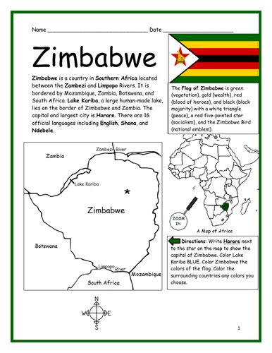
Introduce your students to ZIMBABWE in Africa with this printable handout of two worksheets (plus answer key). Your students will read a brief introduction to Zimbabwe (location, capital, flag, language), write ‘Harare’ next to the star on the map to show the capital, color the small map, and use the map and compass to answer 9 questions on page 2. Colored pencils and a pen or pencil are needed for this activity. No other prep needed. Basic Geography worksheet includes a simple map to introduce the country of Zimbabwe and practice cardinal/ordinal directions.
For use with Interactive Notebooks: After the worksheets are completed, students can cut out the map and flag and paste into the notebook under the topic of Africa/Sub-topic: Zimbabwe. Under the map and flag, your students can write a summary in their own words of what they now know about this country. Collect handouts for other countries of Africa to add to the notebook! Please browse this store for a selection of printable handouts for other countries of Africa (and beyond!).
Thank you so much for using my Geography worksheets in your classroom!
Included in resource: Lake Kariba, Zambezi River, Limpopo River, South Africa, Botswana, Zambia, Mozambique.
Resource Room
Introduce your students to SOMALIA in Africa with this printable handout of two worksheets (plus answer key). Your students will read a brief introduction to Somalia (location, capital, flag, language), write ‘Mogadishu’ next to the star on the map to show the capital, trace the line of the equator, color the small map, and use the map and compass to answer 9 questions on page 2. Colored pencils and a pen or pencil are needed for this activity. No other prep needed. Basic Geography worksheet includes a simple map to introduce Somalia and practice cardinal/ordinal directions.
For use with Interactive Notebooks: After the worksheets are completed, students can cut out the map and flag and paste into the notebook under the topic of Africa/Sub-topic: Somalia (or Horn of Africa). Under the map and flag, your students can write a summary in their own words of what they now know about this country. Collect handouts for other countries of Africa to add to the notebook! Please browse this store for a selection of printable handouts for other countries of Africa (and beyond!).
Thank you for using my Geography worksheets in your classroom! I hope you find them useful. Reviews are welcome and very much appreciated!
Included on map: Horn of Africa, Ethiopia, Djibouti, Kenya, Gulf of Aden, Somali Sea, Indian Ocean, Equator
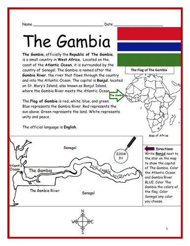
Introduce your students to THE GAMBIA in Africa with this printable handout of two worksheets (plus answer key). Your students will read a brief introduction to The Gambia (location, capital, flag, language), write ‘Banjul’ next to the star on the map to show the capital, color the small map, and use the map and compass to answer 7 questions on page 2. Colored pencils and a pen or pencil are needed for this activity. No other prep needed. Basic Geography worksheet includes a simple map to introduce The Gambia and practice cardinal/ordinal directions.
For use with Interactive Notebooks: After the worksheets are completed, students can cut out the map and flag and paste into the notebook under the topic of Africa/Sub-topic: The Gambia. Under the map and flag, your students can write a summary in their own words of what they now know about this country. Collect handouts for other countries of Africa to add to the notebook! Please browse this store for a selection of printable Geography worksheets for other countries of Africa (and beyond!).
Thank you so much for using my Geography worksheets in your classroom! I hope you find them useful. Reviews are welcome and very much appreciated!
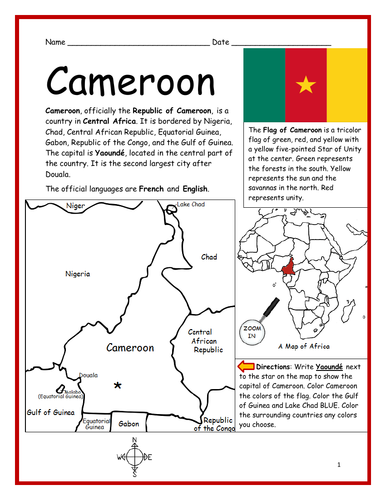
Introduce your students to CAMEROON in Africa with two worksheets (plus answer key). Your students will read a brief introduction to Cameroon (location, capital, flag, language), write ‘Yaoundé’ next to the star on the map to show the location of the capital, color the small map, and use the map and compass to answer 7 questions on page 2. Colored pencils and a pen or pencil are needed for this activity. No other prep needed. Basic Geography worksheet with a simple map to introduce Cameroon and practice cardinal/ordinal directions.
For use with Interactive Notebooks: After the worksheets are completed, students can cut out the map and flag and paste into the notebook under the topic of Africa/Sub-topic: Cameroon. Under the map and flag, your students can write a summary in their own words of what they now know about this country. Collect worksheets for other countries of Africa to add to the notebook! Available individually or as a discounted COUNTRIES OF AFRICA BUNDLE.
Thank you so much for using my Geography worksheets in your classroom! I hope you find them useful. Reviews are welcome and very much appreciated.
Included: Nigeria, Niger, Chad, Central African Republic, Equatorial Guinea, Gabon, Republic of the Congo, Gulf of Guinea, Douala.
Introduce your learners to United Arab Emirates in the Middle East and Asia with this printable handout of two worksheets (plus answer key). Your students will read a brief introduction to UAE (location, capital, language, flag), write ‘Abu Dhabi’ next to the star on the map to show the location of the capital, color the small map, and use the map and compass to answer 9 questions on page 2. Colored pencils and a pen or pencil are needed for this activity. No other prep needed. Basic Geography worksheet with a simple map to introduce UAE and practice cardinal/ordinal directions.
For use with Interactive Notebooks: After your students complete the worksheets, they can cut out the map and flag of UAE and paste into the notebook under the topic of Asia or Middle East / Sub-topic: United Arab Emirates. Under the map, students can write a summary in their own words of what they now know about this country. Collect worksheets for other countries of Asia or the Middle East to add to the notebook! All available in this store. Please browse this store for a selection of printable worksheets for other countries of Asia, the Middle East, and beyond!
Thank you so much for using my Geography worksheets in your classroom! I hope you find them useful. Reviews are welcome and very much appreciated.
Included: Persian Gulf, Gulf of Oman, Arabian Peninsula, maritime borders, Arabic, Pan-Arab colors, 7 emirates
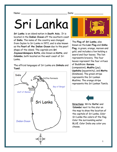
Introduce your learners to the country of Sri Lanka in South Asia with two worksheets (plus answer key). Your students will read a brief introduction to Sri Lanka (location, capital, language, flag), write ‘Kotte’ and ‘Colombia’ next to the star on the map to show the location of the capitals, color the small map, and use the map and compass to answer 7 true/false questions on page 2. Colored pencils and a pen or pencil are needed for this activity. No other prep needed. Basic Geography worksheet with a simple map to introduce Sri Lanka and practice cardinal and ordinal directions.
For use with Interactive Notebooks: After the worksheets are completed, students can cut out the map and flag and paste into the notebook under the topic of Asia / Sub-topic: Sri Lanka. Under the map, students can write a summary in their own words of what they now know about this country. Collect worksheets for other countries of Asia to add to the notebook! All available in this store!
Thank you so much for using my Geography worksheets in your classroom! I hope you find them useful. Reviews are welcome and very much appreciated! Please browse this store for worksheets to introduce your students to the countries of Asia and around the world!
Included: Lion Flag, Sinha, Sri Jayewardenepura Kotte, Pearl of the Indian Ocean, India, Ceylon, Pearl of the Indian Ocean, Bay of Bengal