Thank you for visiting! Here you will find a selection of printable, interactive worksheets for your classroom: Basic Geography worksheets with simple maps, ESL, Spanish, Bible, Reading Comprehension and more. I hope you find the resources useful! Reviews are welcome and very much appreciated. Thank you so much.
Thank you for visiting! Here you will find a selection of printable, interactive worksheets for your classroom: Basic Geography worksheets with simple maps, ESL, Spanish, Bible, Reading Comprehension and more. I hope you find the resources useful! Reviews are welcome and very much appreciated. Thank you so much.
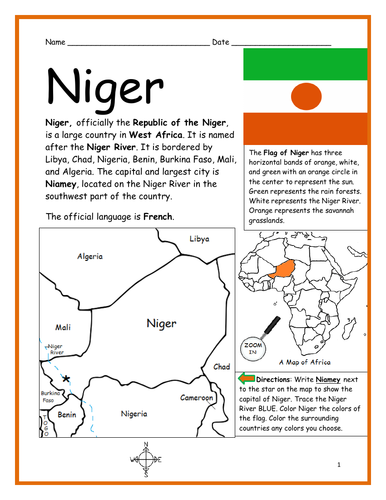
Introduce your students to the country of NIGER in Africa with this printable handout of two worksheets (plus answer key). Your students will read a brief introduction to Niger (location, capital, flag, language), write ‘Niamey’ next to the star on the map to show the capital, trace the Niger River blue, color the small map, and use the map and compass to answer 9 questions on page 2. Colored pencils and a pen or pencil are needed for this activity. No other prep needed. Basic Geography worksheet includes a simple map to introduce Niger and practice cardinal/ordinal directions.
For use with Interactive Notebooks: After the worksheets are completed, students can cut out the map and flag and paste into the notebook under the topic of Africa/Sub-topic: Niger. Under the map and flag, your students can write a summary in their own words of what they now know about this country. Collect handouts for other countries of Africa to add to the notebook! Please browse this store for a selection of printable handouts for other countries of Africa (and beyond!).
Thank you so much for using my Geography worksheets in your classroom! I hope you find them useful. Reviews are welcome and very much appreciated!
Introduce your students to the country of LIBERIA in West Africa with this printable handout of two worksheets (plus answer key). Your students will read a brief overview of Liberia (location, capital, flag, language), write ‘Monrovia’ next to the star on the map to show the capital, color the small map, and use the map and compass to answer 8 questions on page 2. Colored pencils and a pen or pencil are needed for this activity. No other prep needed. Basic Geography worksheet includes a simple map to introduce Liberia and practice cardinal/ordinal directions.
For use with Interactive Notebooks: After the handout is completed, students can cut out the map and flag and paste into the notebook under the topic of Africa/Sub-topic: Liberia. Under the map and flag, your students can write a summary in their own words of what they now know about this country. Collect handouts for other countries of Africa to add to the notebook! Please browse this store for a selection of printable handouts for other countries of Africa (and beyond!)
Thank you so much for using my Geography worksheets in your classroom!
Resource room. Homework. Interactive notebook activity.
Introduce your students to the country of SOUTH SUDAN in Africa with this printable handout of two worksheets (plus answer key). Your students will read a brief overview of South Sudan (location, capital, flag, language), write ‘Juba’ next to the star on the map to show the capital, trace the line of White Nile, color the small map, and use the map and compass to answer 9 questions on page 2. Colored pencils and a pen or pencil are needed for this activity. No other prep needed. Basic Geography worksheet includes a simple map to introduce South Sudan and practice cardinal/ordinal directions.
For use with Interactive Notebooks: After the handout is completed, students can cut out the map and flag and paste into the notebook under the topic of Africa/Sub-topic: South Sudan. Under the map and flag, your students can write a summary in their own words of what they now know about this country. Collect handouts for other countries of Africa to add to the notebook! Please browse this store for a selection of printable handouts for other countries of Africa (and beyond!).
Thank you so much for using my Geography worksheets in your classroom!
Included on this map: Sudan, Ethiopia, Kenya, Uganda, DR Congo, CAR, disputed territories Abyei Area and Ilemi Triangle. South Sudan gained independence from Sudan in 2011.
Introduce your students to SUDAN in Africa with this printable handout of two worksheets (plus answer key). Your students will read a brief introduction to Sudan (location, capital, flag, language), write ‘Khartoum’ next to the star on the map to show the capital, trace the lines of the Blue Nile and White Nile, color the small map, and use the map and compass to answer 9 questions on page 2. Colored pencils and a pen or pencil are needed for this activity. No other prep needed. Basic Geography worksheet includes a simple map to introduce Sudan and practice cardinal/ordinal directions.
For use with Interactive Notebooks: After the worksheets are completed, students can cut out the map and flag and paste into the notebook under the topic of Africa/Sub-topic: Sudan. Under the map and flag, your students can write a summary in their own words of what they now know about this country. Collect worksheets for other countries of Africa to add to the notebook! Please browse this store for a selection of printable handouts for all other countries of Africa (and beyond!).
Thank you so much for using my Geography worksheets in your classroom! I hope you find them useful! Reviews are welcome and very much appreciated.
Included on this map: Egypt, Red Sea, Eritrea, Ethiopia, South Sudan, Central African Republic, Chad, Libya.
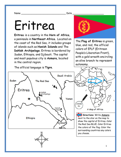
Introduce your students to ERITREA in the Horn of Africa with this printable handout of two worksheets (plus answer key). Your students will read a brief overview of Eritrea (location, capital, flag, language), write ‘Asmara’ next to the star on the map to show the capital, color the small map, and use the map and compass to answer 8 questions on page 2. Colored pencils and a pen or pencil are needed for this activity. No other prep needed. Basic Geography worksheet includes a simple map to introduce Eritrea and practice cardinal/ordinal directions.
For use with Interactive Notebooks: After the handout is completed, students can cut out the map and flag and paste into the notebook under the topic of Africa/Sub-topic: Eritrea. Under the map and flag, your students can write a summary in their own words of what they now know about this country. Collect handouts for other countries of Africa to add to the notebook! Please browse this store for a selection of printable handouts for other countries of Africa (and beyond!).
Thank you so much for using my Geography worksheets in your classroom!
Included on this map: Horn of Africa, Red Sea, Sudan, Ethiopia, Djibouti, Dahlak Archipelago, Hanish Islands.
Introduce your students to DJIBOUTI in Africa with this printable handout of two worksheets (plus answer key). Your students will read a brief introduction to Djibouti (location, capital, flag, language), write ‘Djibouti’ next to the star on the map to show the capital, color the small map, and use the map and compass to answer 8 questions on page 2. Colored pencils and a pen or pencil are needed for this activity. No other prep needed. Basic Geography worksheet includes a simple map to introduce Djibouti and practice cardinal/ordinal directions.
For use with Interactive Notebooks: After the worksheets are completed, students can cut out the map and flag and paste into the notebook under the topic of Africa/Sub-topic: Djibouti. Under the map and flag, your students can write a summary in their own words of what they now know about this country. Collect handouts for other countries of Africa to add to the notebook! Please browse this store for a selection of printable handouts for other countries of Africa (and beyond!).
Thank you so much for using my Geography worksheets in your classroom! I hope you find them useful. Reviews are welcome and very much appreciated!
Introduce your students to SOMALIA in Africa with this printable handout of two worksheets (plus answer key). Your students will read a brief introduction to Somalia (location, capital, flag, language), write ‘Mogadishu’ next to the star on the map to show the capital, trace the line of the equator, color the small map, and use the map and compass to answer 9 questions on page 2. Colored pencils and a pen or pencil are needed for this activity. No other prep needed. Basic Geography worksheet includes a simple map to introduce Somalia and practice cardinal/ordinal directions.
For use with Interactive Notebooks: After the worksheets are completed, students can cut out the map and flag and paste into the notebook under the topic of Africa/Sub-topic: Somalia (or Horn of Africa). Under the map and flag, your students can write a summary in their own words of what they now know about this country. Collect handouts for other countries of Africa to add to the notebook! Please browse this store for a selection of printable handouts for other countries of Africa (and beyond!).
Thank you for using my Geography worksheets in your classroom! I hope you find them useful. Reviews are welcome and very much appreciated!
Included on map: Horn of Africa, Ethiopia, Djibouti, Kenya, Gulf of Aden, Somali Sea, Indian Ocean, Equator
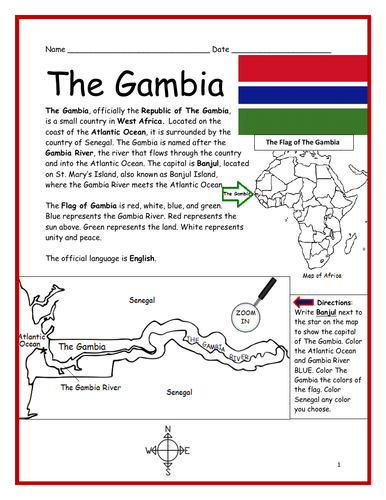
Introduce your students to THE GAMBIA in Africa with this printable handout of two worksheets (plus answer key). Your students will read a brief introduction to The Gambia (location, capital, flag, language), write ‘Banjul’ next to the star on the map to show the capital, color the small map, and use the map and compass to answer 7 questions on page 2. Colored pencils and a pen or pencil are needed for this activity. No other prep needed. Basic Geography worksheet includes a simple map to introduce The Gambia and practice cardinal/ordinal directions.
For use with Interactive Notebooks: After the worksheets are completed, students can cut out the map and flag and paste into the notebook under the topic of Africa/Sub-topic: The Gambia. Under the map and flag, your students can write a summary in their own words of what they now know about this country. Collect handouts for other countries of Africa to add to the notebook! Please browse this store for a selection of printable Geography worksheets for other countries of Africa (and beyond!).
Thank you so much for using my Geography worksheets in your classroom! I hope you find them useful. Reviews are welcome and very much appreciated!
Introduce your students to REPUBLIC OF THE CONGO in Africa with this printable handout of two worksheets (plus answer key). Your students will read a brief introduction to Republic of the Congo (location, capital, flag, language), write ‘Brazzaville’ next to the star on the map to show the location of the capital, color the small map, and use the map and compass to answer 9 questions on page 2. Colored pencils and a pen or pencil are needed for this activity. No other prep needed. Basic Geography worksheet includes a simple map to introduce Republic of the Congo and practice cardinal/ordinal directions.
For use with Interactive Notebooks: After the worksheets are completed, students can cut out the map and flag and paste into the notebook under the topic of Africa/Sub-topic: Republic of the Congo. Under the map and flag, your students can write a summary in their own words of what they now know about this country. Collect handouts for other countries of Africa to add to the notebook! Please browse this store for a selection of printable Geography worksheets for other countries of Africa (and beyond!).
Thank you so much for using my Geography worksheets in your classroom! I hope you find them useful. Reviews are welcome and very much appreciated!
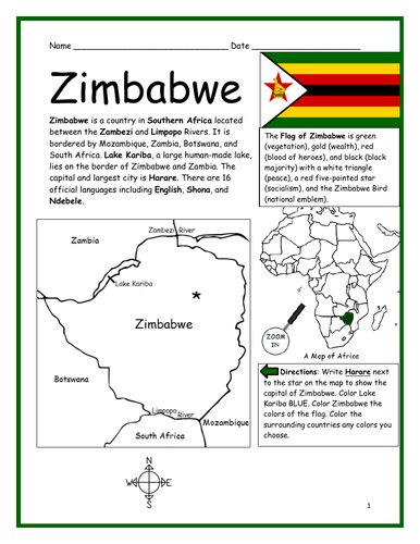
Introduce your students to ZIMBABWE in Africa with this printable handout of two worksheets (plus answer key). Your students will read a brief introduction to Zimbabwe (location, capital, flag, language), write ‘Harare’ next to the star on the map to show the capital, color the small map, and use the map and compass to answer 9 questions on page 2. Colored pencils and a pen or pencil are needed for this activity. No other prep needed. Basic Geography worksheet includes a simple map to introduce the country of Zimbabwe and practice cardinal/ordinal directions.
For use with Interactive Notebooks: After the worksheets are completed, students can cut out the map and flag and paste into the notebook under the topic of Africa/Sub-topic: Zimbabwe. Under the map and flag, your students can write a summary in their own words of what they now know about this country. Collect handouts for other countries of Africa to add to the notebook! Please browse this store for a selection of printable handouts for other countries of Africa (and beyond!).
Thank you so much for using my Geography worksheets in your classroom!
Included in resource: Lake Kariba, Zambezi River, Limpopo River, South Africa, Botswana, Zambia, Mozambique.
Resource Room
Introduce your students to GHANA in Africa with two worksheets (plus answer key). Your students will read a brief introductio to Ghana (location, capital, flag, language), write ‘Accra’ next to the star on the map to show the capital, color the small map, and use the map and compass to answer 9 questions on page 2. Colored pencils and a pen or pencil are needed for this activity. No other prep needed. Basic Geography worksheet with a simple map to introduce the country of Ghana and practice cardinal/ordinal directions.
For use with Interactive Notebooks: After the worksheets are completed, students can cut out the map and flag and paste into the notebook under the topic of Africa/Sub-topic: GHANA. Under the map and flag, your students can write a summary in their own words of what they now know about this country. Collect worksheets for other countries of Africa to add to the notebook! Please browse this store for a selection of printable handouts for other countries of Africa (and beyond!).
Thank you so much for using my Geography worksheets in your classroom!
Introduce your students to LIBYA in Africa with two worksheets (plus answer key). Your students will read a brief introduction to Libya (location, capital, flag, language), write ‘Tripoli’ next to the star on the map to show the capital, color the small map, and use the map and compass to answer 9 questions on page 2. Colored pencils and a pen or pencil are needed for this activity. No other prep needed. Basic Geography worksheet with a simple map to introduce the country of Libya and practice cardinal/ordinal directions.
For use with Interactive Notebooks: After the worksheets are completed, students can cut out the map and flag and paste into the notebook under the topic of Africa/Sub-topic: Libya. Under the map and flag, your students can write a summary in their own words of what they now know about this country. Collect handouts for other countries of Africa to add to the notebook! Please browse this store for a selection of printable Geography worksheets for other countries of Africa (and beyond!)
Thank you so much for using my Geography worksheets in your classroom! I hope you find them useful.
Included on this map: Fezzan, Cyrenaica, Tripolitania, Mediterranean Sea, Egypt, Sudan, Chad, Niger, Algeria, Tunisia.
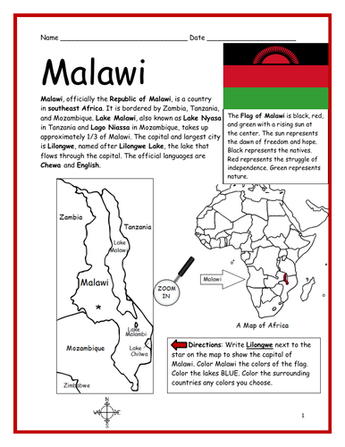
Introduce your students to MALAWI in Africa with this printable handout of two worksheets (plus answer key). Your students will read a brief introduction to Malawi (location, capital, flag, language), write ‘Lilongwe’ next to the star on the map to show the capital, color the small map, and use the map and compass to answer 7 questions on page 2. Colored pencils and a pen or pencil are needed for this activity. No other prep needed. Basic Geography worksheet includes a simple map to introduce the country of Malawi and practice cardinal/ordinal directions.
For use with Interactive Notebooks: After the worksheets are completed, students can cut out the map and flag and paste into the notebook under the topic of Africa/Sub-topic: Malawi. Under the map and flag, your students can write a summary in their own words of what they now know about this country. Collect worksheets for other countries of Africa to add to the notebook! Please browse this store for a selection of printable worksheets for other countries of Africa (and beyond!).
Thank you so much for using my Geography worksheets in your classroom! I hope you find them useful. Reviews are welcome and very much appreciated!
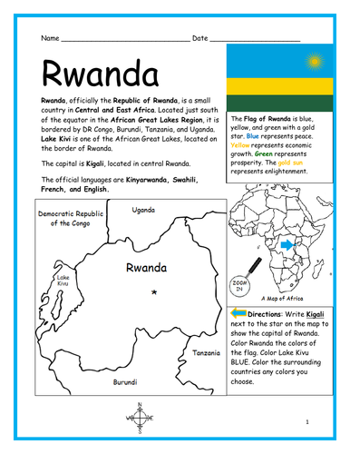
Introduce your students to the country of RWANDA with this printable handout of two worksheets (plus answer key). Your students will read a brief introduction to Rwanda (location, capital, flag, language), write ‘Kigali’ next to the star on the map to show the capital, color the small map, and use the map and compass to answer 7 questions on page 2. Colored pencils and a pen or pencil are needed for this activity. No other prep needed. Basic Geography worksheet includes a simple map to introduce the country of Rwanda and practice cardinal/ordinal directions.
For use with Interactive Notebooks: After the worksheets are completed, students can cut out the map and flag and paste into the notebook under the topic of Africa/Sub-topic: Rwanda. Under the map and flag, your students can write a summary in their own words of what they now know about this country. Collect worksheets for other countries of Africa to add to the notebook! Please browse this store for a selection of printable Geography worksheets for other countries of Africa (and beyond!).
Thank you so much for using my Geography worksheets in your classroom!
Introduce your students to CHAD with two worksheets (plus answer key). Your students will read a brief introduction to Chad (location, capital, flag, language), write ‘N’Djamena’ next to the star on the map to show the location of the capital, color the small map, and use the map and compass to answer 9 questions on page 2. Colored pencils and a pen or pencil are needed for this activity. No other prep needed. Basic Geography worksheet with a simple map to introduce the country of Chad and practice cardinal/ordinal directions.
For use with Interactive Notebooks: After the worksheets are completed, students can cut out the map and flag and paste into the notebook under the topic of Africa/Sub-topic: Chad. Under the map and flag, your students can write a summary in their own words of what they now know about this country. Collect worksheets for other countries of Africa to add to the notebook! Please browse this store for a selection of worksheets for all other countries of Africa (and beyond!).
Thank you so much for using my Geography worksheets in your classroom! I hope you find them useful. Reviews are welcome and very much appreciated.
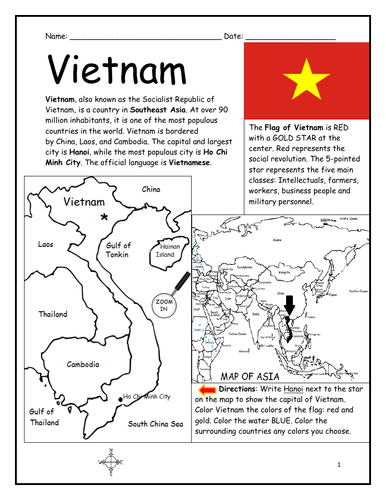
Introduce your students to VIETNAM with this printable handout of two worksheets (plus answer key). Your students will read a brief introduction to Vietnam (location, capital, flag, language), write 'Hanoi’ next to the star on the map to show the capital, color the small map of Vietnam and surrounding, and use the map and compass to answer 7 questions on page 2. Colored pencils and a pen or pencil are needed for this activity. No other prep needed. Basic Geography worksheet with a simple map to introduce Vietnam and practice cardinal and ordinal directions.
For use with Interactive Notebooks: After the worksheets are completed, students can cut out the map and flag and paste into the notebook under the topic of Asia/Sub-Topic: Vietnam. Under the map and flag, your students can write a summary in their own words of what they now know about Vietnam. Collect handouts for other countries of Asia to add to the notebook! All available in this store. Please browse this store for a selection of printable Geography worksheets for countries of Asia (and beyond!).
Thank you for using my Geography worksheets in your classroom! I hope you find them useful. Reviews are welcome and very much appreciated!
Introduce your students to the 7 continents with this printable handout of 2 worksheets (plus answer key). Your students will write the name of each continent on the map: Africa, Antarctica, Asia, Europe, North America, Oceania (Australia), and South America, trace the line of the equator, color the small map, and use the map and compass to answer 7 questions. Colored pencils and a pen or pencil are needed for this activity. No other prep needed. Basic geography worksheet with a simple map to introduce the continents and practice cardinal and ordinal directions.
For use with Interactive Notebooks: After the handout is completed, students can cut out the map of the 7 continents and paste into the notebook. Under the map, students can write a summary in their own words of what they now know about the continents. Collect handouts for countries of Africa, Antarctica, Asia, Europe, North America, Oceania/Australia, and South America to add to the notebook! Please browse this store for a selection of printable handouts.
Thank you so much for using my Geography worksheets in your classroom! I hope you find them useful!
Introduce your students to MOROCCO with two worksheets (plus answer key). Your students will read a brief introduction to Morocco (location, capital, flag, language), write ‘Rabat’ next to the star on the map to show the location of the capital, color the small map, and use the map and compass to answer 8 questions on page 2. Colored pencils and a pen or pencil are needed for this activity. No other prep needed. Basic Geography worksheet with a simple map to introduce Morocco and practice cardinal and ordinal directions.
For use with Interactive Notebooks: After the worksheets are completed, students can cut out the map and flag and paste into the notebook under the topic of Africa/Sub-topic: Morocco. Under the map and flag, your students can write a summary in their own words of what they now know about this country. Collect worksheets for other countries of Africa to add to the notebook! Please browse this store for a selection of worksheets for other countries of Africa (and beyond!).
Thank you so much for using my Geography worksheets in your classroom! I hope you find them useful. Reviews are welcome and very much appreciated.
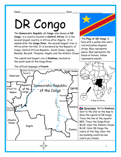
Introduce your students to the Democratic Republic of Congo (DR Congo) with this printable handout of two worksheets (plus answer key). Your students will read a brief introduction to DR Congo (location, capital, flag, language), write ‘Kinshasa’ next to the star on the map to show the capital, trace the lines to show the location of the equator and Congo River, color the small map, and use the map and compass to answer 9 questions on page 2. Colored pencils and a pen or pencil are needed for this activity. No other prep needed. Basic Geography worksheet with a simple map to introduce DR Congo and practice cardinal and ordinal directions.
For use with Interactive Notebooks: After the worksheets are completed, students can cut out the map and flag and paste into the notebook under the topic of Africa/Sub-topic: DR Congo. Under the map and flag, your students can write a summary in their own words of what they now know about this country. Collect handouts for other countries of Africa to add to the notebook! Please browse this store for a selection of printable worksheets for other countries of Africa (and beyond!).
Thank you so much for using my Geography worksheets in your classroom! I hope you find them useful! Reviews are welcome and very much appreciated!
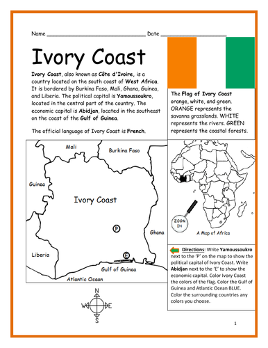
Introduce your learners to IVORY COAST (Côte d’Ivoire) in Africa with two worksheets (plus answer key). Your students will read a brief introduction to Ivory Coast (location, capital, flag, language), write ‘Yamoussoukro’ next to the ‘P’ on the map to show the political capital of Ivory Coast, write ‘Abidjan’ next to the ‘E’ to show the economic capital, color the small map, and use the map and compass to answer 9 questions on page 2. Colored pencils and a pen or pencil are needed for this activity. No other prep needed. Basic Geography worksheet with a simple map to introduce Ivory Coast and practice cardinal and ordinal directions.
For use with Interactive Notebooks: After the worksheets are completed, students can cut out the map and flag and paste into the notebook under the topic of Africa/Sub-topic: Ivory Coast. Under the map and flag, students can write a summary in their own words of what they now know about this country. Collect worksheets for other countries of Africa to add to the notebook! Please browse this store for a selection of worksheets for other countries of Africa (and beyond!).
Thank you so much for using my worksheets in your classroom! Reviews are welcome and very much appreciated!