Thank you for visiting! Here you will find a selection of printable, interactive worksheets for your classroom: Basic Geography worksheets with simple maps, ESL, Spanish, Bible, Reading Comprehension and more. I hope you find the resources useful! Reviews are welcome and very much appreciated. Thank you so much.
Thank you for visiting! Here you will find a selection of printable, interactive worksheets for your classroom: Basic Geography worksheets with simple maps, ESL, Spanish, Bible, Reading Comprehension and more. I hope you find the resources useful! Reviews are welcome and very much appreciated. Thank you so much.
Learn about New York with this bundle of printable Geography handouts:
New York: 2 worksheets (plus answer key). Your students will read a brief overview of New York (location, capital, state bird, state flower, abbreviation), write ‘Albany’ next to the star on the map to show the capital of New York, color a small map and then use the map and compass to answer 8 questions.
Long Island: 2 worksheets (plus answer key). Your students will read a brief overview of Long Island, color a small map, and use the map and compass to answer 8 questions. Map includes Suffolk County, Nassau County, Queens and Brooklyn, separated by the Bronx and Manhattan by the East River. Atlantic Ocean, Long Island Sound, Hudson River, The Hamptons, North Fork, South Fork, Montauk.
Northeastern Region of the United States: 2 worksheets (plus answer key). This list includes 11 states: The states of New England: Maine (ME), New Hampshire (NH), Vermont (VT), Massachusetts (MA), Rhode Island (RI), and Connecticut (CT), and the Middle States: New York (NY), Pennsylvania (PA), New Jersey (NJ) and Delaware (DE). Your students will write the full name of each state on the map, then color the six states of New England one color and the middle states another color. Then they will use the map and compass to answer six questions.
Color the map of the United States: 1 printable handout with map to color.
For use with Interactive Notebooks: After the handout is completed and the map is colored and questions are answered, cut out the map and paste it into the notebook under the topic of United States / sub-topic New York. Under the map, students will write a summary in their own words of what they now know about the state/region.
Introduce your learners to India with this printable handout of two worksheets (plus answer key). Your students will read a brief introduction to India (location, capital, flag, language), write ‘New Delhi’ next to the star on the map to show the location of the capital, color the small map and flag, and use the map and compass to answer 8 questions on page 2. Colored pencils and a pen or pencil are needed for this activity. No other prep needed. Basic Geography worksheet with a simple map to introduce India and practice cardinal and ordinal directions.
For use with INTERACTIVE NOTEBOOKS: After the worksheets are completed, students can cut out the map and flag and paste into the notebook under the topic of Asia/subtopic: India. Under the map and flag, students can write a summary in their own words of what they now know about this country. Collect worksheets for other countries of Asia to add to the notebook. Please browse this store for a selection of worksheets for other countries of Asia (and beyond!).
Thank you so much for using my Geography worksheets in your classroom! I hope you find them useful. Reviews are welcome and very much appreciated!
India and surrounding: Indian Ocean, Arabian Sea, Bay of Bengal, Pakistan, Afghanistan, China, Nepal, Bhutan, Bangladesh, Myanmar. Official language is Hindi.
Introduce your students to Long Island, New York with this printable handout of 2 worksheets (plus answer key). Your students will read a brief introduction to Long Island, New York, color the small map, and use the map and compass to answer 8 questions on page 2. Answer key included.
Map includes Suffolk County, Nassau County, Queens and Brooklyn, separated by the Bronx and Manhattan by the East River. Atlantic Ocean, Long Island Sound, Hudson River, The Hamptons, North Fork, South Fork, Montauk.
Thanks so much for using my worksheets in your classroom! I hope you find them useful. Reviews are welcome and very much appreciated! Please browse this store for more worksheets to introduce your learners to the countries of the world!
Cut out each flag and paste into the map of Central America: Belize, Guatemala, Honduras, El Salvador, Costa Rica, Nicaragua, Panama. This printable handout includes 7 flags and a map to cut out and paste into your interactive notebook.
Assign a state or have your students choose a state to learn about on their own. With this printable blank ‘State Fact Sheet,’ your students will write the name of the assigned state, find the location of that state on the map of the United States, fill in the state capital, state abbreviation, state governor, state flag, state bird, state flower, and list any other interesting facts they learned in their research.
Introduce your learners to HAITI with this printable handout of 2 worksheets (plus answer key). Your students will read a brief introduction to Haiti (location, capital, flag, islands); write ‘Port-au-Prince’ next to the star on the map to show the location of the capital, color the flag and map, and use the map and compass to answer 8 questions on page 2. Colored pencils and a pen or pencil are needed for this activity. No other prep needed. Basic Geography worksheet with a simple map to introduce Haiti and practice cardinal and ordinal directions.
For use with Interactive Notebooks: After the worksheets are completed, students can cut out the map and flag and paste into the notebook under the topic of Caribbean Islands / Sub-topic: Haiti. Under the map and flag, your students can write a summary in their own words of what they now know about Haiti. Collect worksheets for other countries to add to the notebook! Please browse this store for a selection of worksheets for other countries of the Caribbean (and beyond!).
Haiti and surrounding: Caribbean Sea, Atlantic Ocean, Gulf of Gonâve, Dominican Republic, Cuba, Island of Hispaniola. Islands of Haiti include: Tortuga, Gonâve, Île-à-Vache, and Les Cayemites. Coat of Arms: L’Union Fait La Force (Unity Is Strength). Cardinal, ordinal direction.
Thank you so much for using my Geography worksheets in your classroom! I hope you find them useful! Reviews are welcome and very much appreciated.
Find all 50 states in the word search puzzle using the list of states on page 2.
States to find in the Word Search Puzzle: Alabama, Alaska, Arizona, Arkansas, California, Colorado, Connecticut, Delaware, Florida, Georgia, Hawaii, Idaho. Illinois. Indiana. Iowa, Kansas. Kentucky. Louisiana, Maine. Maryland, Massachusetts. Michigan. Minnesota. Mississippi. Missouri. Montana. Nebraska. Nevada. New Hampshire. New Jersey. New Mexico. New York. North Carolina. North Dakota. Ohio. Oklahoma. Oregon. Pennsylvania. Rhode Island. South Carolina. South Dakota, Tennessee. Texas. Utah Vermont. Virginia, Washington, West Virginia, Wisconsin, Wyoming
Thank you!!
Can your students name all 50 states of the United States of America? This bundle includes a printable map of the United States to color and learn; a printable map where your students will write the name of each state on the map, a printable worksheet where your students will fill in the blank letters for each US State, and a Word Search Puzzle where your students will find all 50 states in the puzzle and then write the leftover letters to spell out a fun-fact about the United States. (The ‘fun fact’ from the leftover letters will read: The longest boardwalk in the world is located in the United States in New Jersey in Atlantic City.) Also included is a blank State Fact Sheet that your students can use to research a specific state. The Pledge of Allegiance worksheet to match the word to the definition (pledge, allegiance, republic, indivisible, liberty, justice).
Thank you so much for using my printable worksheets in your classroom!
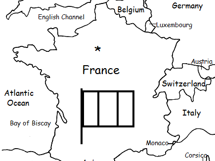
Introduce your students to France with this printable handout of two worksheets (plus answer key). Your students will read a brief introduction to France (location, capital, flag, language), write ‘Paris’ next to the star on the map to show the location of the capital, color the small map and flag, and use the map and compass to answer 7 questions on page 2. Colored pencils and a pen or pencil are needed for this activity. No other prep needed. Basic geography worksheet includes a simple map to introduce France and practice cardinal/ordinal directions.
For use with Interactive Notebooks: After completing the worksheets, students can cut out the map and flag and paste it into the notebook under the topic of Europe/Sub-Topic: France. Under the map and flag, students can write a summary in their own words of what they now know about France. Collect worksheets for other countries of Europe to add to the notebook! Please browse this store for a selection of worksheets for other countries of Europe (and beyond!).
Thank you so much for using my Geography worksheets in your classroom! Reviews are welcome and very much appreciated.
Included on map: Belgium, Luxembourg, Germany, Switzerland, Italy, Monaco, Andorra, Spain, Corsica, United Kingdom, Netherlands, Austria, North Sea, English Channel, Bay of Biscay, Mediterranean Sea, Atlantic Ocean.
Introduce your learners to CHINA with this printable handout of two worksheets (plus answer key). Your students will read a brief introduction to China (location, capital, language, flag), write ‘Beijing’ next to the star on the map to show the location of the capital, color the flag and map, and use the map and compass to answer 10 questions on page 2. Colored pencils and a pen or pencil are needed for this activity. No other prep needed. Basic Geography worksheet with a simple map to introduce China and practice cardinal/ordinal directions.
For use with Interactive Notebooks: After your students complete the worksheets, they can cut out the map and paste into the notebook under the topic Asia/Sub-topic: China. Under the map, your students can write a summary in their own words of what they now know about China. Collect worksheets for other countries of Asia to add to the notebook! Please browse this store for a selection of printable Geography worksheets for other countries of Asia (and beyond!).
Thank you so much for using my Geography worksheets in your classroom! I hope you find them useful! Reviews are welcome and very much appreciated.
Notes: China shares land borders with 14 countries: Vietnam, Laos, Myanmar,
India, Bhutan, Nepal, Afghanistan, Pakistan, Tajikistan,
Kyrgyzstan, Kazakhstan, Russia, Mongolia, and North Korea. Pacific Ocean.
Introduce your students to Puerto Rico with this printable handout of two worksheets (plus answer key). Your students will read a brief introduction to Puerto Rico (location, capital, flag, language), write ‘San Juan’ next to the star on the map to show the location of the capital, color the small map and flag, and use the map and compass to answer 6 questions on page 2. Colored pencils and a pen or pencil are needed for this activity. No other prep needed.
For use with Interactive Notebooks: After the worksheets are completed, students can cut out the map and flag of Puerto Rico and paste into the notebook. Under the map and flag, students can write a summary in their own words of what they now know about Puerto Rico. Collect worksheets for other countries to add to the notebook! Please browse this store for a selection of worksheets for Caribbean Islands, Spanish-speaking countries, and beyond!
Thank you so much for using my Geography worksheets in your classroom! I hope you find them useful. Reviews are welcome and very much appreciated!
Included on map of Puerto Rico and surrounding: Atlantic Ocean, Caribbean Sea, Mona, Culebra, Viequez, Desecheo, Florida, Dominican Republic, Haiti, Cuba. Cardinal, ordinal directions.
Introduce your students to IRAQ with this printable handout of two worksheets (plus answer key). Your students will read a brief introduction to Iraq (location, capital, flag, language), write ‘Baghdad’ next to the star on the map to show the capital, color the small flag and map, and use the map and compass to answer 9 questions on page 2. Colored pencils and a pen or pencil are needed for this activity. No other prep needed. Basic Geography worksheet with a simple map to introduce Iraq and practice cardinal and ordinal directions.
For use with Interactive Notebooks: After the worksheets are completed, students can cut out the map and flag and paste into the notebook under the topic of Asia / Sub-Topic: Iraq. Under the map, students can write a summary in their own words of what they now know about this country. Collect worksheets for other countries of Asia to add to the notebook! Please browse this store for worsheets for all other countries of Asia (and beyond!).
Thank you so much for using my Geography worksheets in your classroom! I hope you find them useful. Reviews are welcome and very much appreciated!
Tigris River, Euphrates River, Cardinal, Ordinal directions.
Introduce your students to EQUATORIAL GUINEA with two worksheets (plus answer key). Your students will read a brief introduction to Equatorial Guinea (location, capital, flag, language), write ‘Malabo’ next to the star on the map to show the location of the capital, trace the dotted line to show the equator, color the small flag and map, and then use the map and compass to answer 8 questions on page 2. Pen or pencil and colored pencils needed for this activity. No other prep needed. Basic Geography worksheet with a simple map to introduce Equatorial Guinea and practice cardinal and ordinal directions.
For use with Interactive Notebooks: After the worksheets are completed, students can cut out the map and flag and paste into the notebook under the topic of Topic: Africa / Sub-Topic: Equatorial Guinea. (or Topic: Spanish-Speaking Countries / Sub-Topic: Equatorial Guinea). Under the map, your students can write a summary in their own words of what they now know about this country. Collect worksheets for other countries of Africa or Spanish-speaking countries to add to the notebook! Please browse this store for worksheets for other countries!
Thank you so much for using my Geography worksheets in your classroom! Reviews are welcome and very much appreciated.
Africa, Spanish, Gulf of Guinea, cardinal, ordinal directions.
Introduce your students to the United States of America with two worksheets (plus answer key). Your students will read a brief introduction to the United States (location, capital, flag, language, 13 original colonies), write ‘Washington D.C.’ next to the star on the map to show the location of the capital, color the small map, and use the map and compass to answer 10 questions on page 2.
Please note: This map includes the United States and surrounding, including Canada, Mexico, Atlantic Ocean, Pacific Ocean, Arctic Ocean, Gulf of Mexico, Cuba, Haiti, Dominican Republic, Puerto Rico. Individual states of America are not included on this map (except for Alaska, Hawaii and 13 original colonies). For worksheets to introduce your learners to each of the 50 states of the USA, please browse this store!
For use with Interactive Notebooks: After the worksheet is completed, students can cut out the map and flag and paste into the notebook under the topic of North America/Sub-Topic: United States. Under the map and flag, students can write a summary in their own words of what they now know about the United States of America! Collect worksheets for other countries of North America to add to the notebook! Please browse this store for worksheets to introduce your learners to countries of North America, such as Canada, Mexico, Cuba, Dominican Republic, Haiti, Puerto Rico, and countries of Central America!
Thank you so much for using my Geography worksheets in your classroom! I hope you find them useful. Reviews are welcome and very much appreciated.
Included: Washington D.C. formerly District of Columbia, named after first president and Founding Father George Washington.
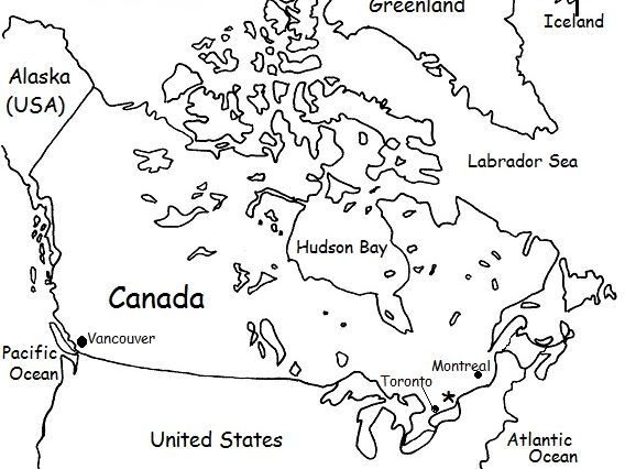
Introduce your students to CANADA with this printable handout of two worksheets (plus answer key). Your students will read a brief overview of Canada (location, capital, flag, language), write ‘Ottawa’ next to the star on the map to show the capital, color the small flag and map, and use the map and compass to answer 9 questions. Colored pencils or crayons and a pen or pencil are needed for this activity. No other prep needed.
For use with Interactive Notebooks: After the handout is completed, students can cut out the map and flag and paste into the notebook under the topic of North America / Sub-Topic: Canada. Under the map and flag, students will write a summary in their own words of what they now know about Canada.
Thank you for using my Geography worksheets in your classroom!
Included on this map: Alaska, Greenland, Iceland, United States, Arctic Ocean, Pacific, Atlantic Ocean, Vancouver, Montreal, Toronto. Cardinal, ordinal directions.
Introduce your students to Japan with this printable handout of two worksheets (plus answer key). Your students will read a brief introductin to Japan (location, capital, flag, language), write ‘Tokyo’ next to the star on the map to show the location of the capital, color the small map and flag, and use the map and compass to answer 7 questions on page 2. Colored pencils and a pen or pencil are needed for this activity. No other prep needed. Basic Geography worksheet with a simple map to introduce Japan and practice cardinal and ordinal directions.
For use with Interactive Notebooks: After the worksheets are completed, students can cut out the map and flag and paste into the notebook under the topic of Asia / Sub-Topic: Japan. Under the map and flag, your students can write a summary in their own words of what they now know about this country. Collect handouts for other countries of Asia to add to the notebook! Please browse this store for a selection of worksheets for all other countries of Asia (and beyond!)
Thank you so much for using my Geography worksheets in your classroom! I hope you find them useful. Reviews are welcome and very much appreciated!
Japanese Archipelago, Islands of Honshu, Hokkaido, Kyushu, Shikoku.
Nisshōki, Hinomaru, Maritime borders. Dialect. Okinawa, Ryukyu Islands.
Introduce your students to the 13 original colonies with this printable handout (1 worksheet plus answer key). This handout includes the list of 13 colonies and the year each was founded before declaring independence and becoming the United States in 1776. Students will write the name of each colony in the order it was founded, then write the number of each on the map. Includes Virginia, New Hampshire, New York, Massachusetts, Maryland, Connecticut, Rhode Island, Delaware, North Carolina, South Carolina, New Jersey, Pennsylvania, Georgia.
Thank you so much for using my worksheets in your classroom!
Introduce your students to Bangladesh with this printable handout of two worksheets (plus answer key). Your students will read a brief introduction to Bangladesh (location, capital, flag, language), write ‘Dhaka’ next to the star on the map to show the location of the capital, color the small map and flag, and use the map and compass to answer 6 questions on page 2. Colored pencils and a pen or pencil are needed for this activity. No other prep needed. Basic Geography worksheet with a simple map to introduce Bangladesh and practice cardinal and ordinal directions.
For use with Interactive Notebooks: After the worksheets are completed, students can cut out the map and flag and paste into the notebook under the topic of Asia / Sub-topic: Bangladesh. Under the map and flag, students can write a summary in their own words of what they now know about this country. Collect worksheets for other countries of Asia to add to the notebook! Please browse this store for a selection of worksheets for countries of Asia (and beyond!)
Thank you for using my Geography worksheets in your classroom! I hope you find them useful. Reviews are welcome and very much appreciated!
Find the 13 Original Colonies in the Word Search Puzzle. They can be found forward or backward. Then write the remaining letters below to spell out a fact about the original colonists (1 printable handout plus answer key).
13 colonies: Connecticut, Delaware, Georgia, Maryland, Massachusetts, New Hampshire, New Jersey, New York, North Carolina, Pennsylvania, Rhode Island, South Carolina, Virginia.
Remaining letters will spell: The first colonists settled near James River in Jamestown, Virginia.
Thank you so much for using my printable handouts in your classroom!
Introduce your students to Suffolk County, Long Island, New York with this printable handout of two worksheets (plus answer key). Your students will read a brief introduction to Suffolk County, study the small map, trace the lines to show Sunrise Highway and the Long Island Expressway, color the Great South Bay, Atlantic Ocean and other surrounding bodies of water blue, and use the map and compass to answer 12 questions on page 2. Answer key included.
For use with Interactive Notebooks: After the worksheets are completed, students can cut out the map and paste into the notebook under the topic of United States / New York / Sub-Topic: Long Island. Under the map, students can write a summary in their own words of what they now know about Suffolk County. Add maps from other worksheets to the notebook! Please browse this store for worksheets to introduce your students to the 50 states of the USA and the countries of the world!
Thank you so much for using my Geography worksheets in your classroom! I hope you find them useful. Reviews are welcome and very much appreciated!