Thank you for visiting! Here you will find a selection of printable, interactive worksheets for your classroom: Basic Geography worksheets with simple maps, ESL, Spanish, Bible, Reading Comprehension and more. I hope you find the resources useful! Reviews are welcome and very much appreciated. Thank you so much.
Thank you for visiting! Here you will find a selection of printable, interactive worksheets for your classroom: Basic Geography worksheets with simple maps, ESL, Spanish, Bible, Reading Comprehension and more. I hope you find the resources useful! Reviews are welcome and very much appreciated. Thank you so much.
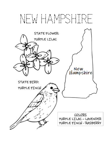
Print and color the state bird and flower of New Hampshire! State Bird: Purple Finch. State Flower: Purple Lilac. One printable coloring page.
Thank you so much for using my coloring pages in your classroom! Reviews are welcome and very much appreciated. Please browse this store for more coloring pages and Geography worksheets!
Introduce your learners to the state of Arizona with this printable handout of two worksheets (plus answer key). Your students will read a brief overview of Arizona (location, capital, flag, state bird, state flower), write ‘Phoenix’ next to the star on the map to show the location of the capital, trace the dotted line of the Four Corners and the Colorado River, color the small map, state bird and state flower, and use the map and compass to answer 10 true/false questions on page 2. Colored pencils and a pen or pencil are needed for this activity. No other prep needed. Basic Geography worksheet with a simple map to introduce the state of Arizona and practice cardinal and ordinal directions.
For use with Interactive Notebooks: After the worksheets are completed, students can cut out the map, flag, state bird and state flower of Arizona and paste into the notebook under the topic of United States/Sub-Topic: Arizona. Under the map, students can write a summary in their own words of what they now know about this state. Collect worksheets for other states of the US to add to the notebook! Please browse this store for a selection of worksheets for other states of the USA (and beyond!).
Thank you so much for using my worksheets in your classroom! Reviews are welcome and very much appreciated!
Included: Grand Canyon, Utah, Colorado, New Mexico, Nevada, California, Mexico, Colorado River, State bird and Flower, Cactus Wren, Saguaro.
Introduce your learners to the state of Ohio in the USA with two worksheets (plus answer key). Your students will read a brief introduction to Ohio (location, capital, flag, state bird, state flower), write ‘Columbus’ next to the star on the map to show the location of the capital, color the small map, state bird and state flower, and use the map and compass to answer 10 true/false questions on page 2. Colored pencils and a pen or pencil are needed for this activity. No other prep needed. Basic Geography worksheet with a simple map to introduce the state of Ohio and practice cardinal and ordinal directions.
For use with Interactive Notebooks: After the worksheets are completed, students can cut out the map, flag, state bird and state flower of Ohio and paste into the notebook under the topic of United States/Sub-Topic: Ohio. Under the map, students can write a summary in their own words of what they now know about this state. Collect worksheets for other states of the US to add to the notebook! Please browse this store for a selection of worksheets for other states of the USA (and beyond!).
Thank you so much for using my worksheets in your classroom! Reviews are welcome and very much appreciated!
Included: Cleveland, Cincinnati, Lake Erie, Pennsylvania, West Virginia, Kentucky, Indiana, Michigan, Cardinal, Scarlet Carnation, 17th state
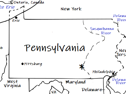
Introduce your learners to the U.S. state of Pennsylvania with this printable handout of two worksheets (plus answer key). Your students will read a brief overview of Pennsylvania (location, capital, flag, state bird, state flower), write ‘Harrisburg’ next to the star on the map to show the location of the capital, trace the lines of the Delaware River and Susquehanna River, color the small map, state bird and state flower, and use the map and compass to answer 10 true/false questions on page 2. Colored pencils and a pen or pencil are needed for this activity. No other prep needed. Basic Geography worksheet with a simple map to introduce the state of Pennsylvania and practice cardinal and ordinal directions.
For use with Interactive Notebooks: After the worksheets are completed, students can cut out the map, flag, state bird and state flower of Pennsylvania and paste into the notebook under the topic of United States/Sub-Topic: Pennsylvania. Under the map, students can write a summary in their own words of what they now know about this state. Collect worksheets for other states of the US to add to the notebook! Please browse this store for a selection of worksheets for other states of the USA (and beyond!).
Thank you so much for using my worksheets in your classroom! Reviews are welcome and very much appreciated! :)
Included: Delaware, Maryland, West Virginia, Ohio, Lake Erie, New York, New Jersey, Appalachian Mountains, Ruffed Grouse, Mountain Laurel, state motto Virtue, Liberty and Independence, Philadelphia, Pittsburg.
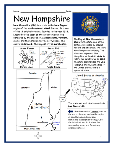
Introduce your learners to the U.S. state of New Hampshire with this printable handout of two worksheets (plus answer key). Your students will read a brief overview of New Hampshire (location, capital, flag, state bird, state flower), write ‘Concord’ next to the star on the map to show the location of the capital, color the small map, state bird and state flower, and use the map and compass to answer 10 true/false questions on page 2. Colored pencils and a pen or pencil are needed for this activity. No other prep needed. Basic Geography worksheet with a simple map to introduce the state of New Hampshire and practice cardinal and ordinal directions.
For use with Interactive Notebooks: After the worksheets are completed, students can cut out the map, flag, state bird and state flower of New Hampshire and paste into the notebook under the topic of United States/Sub-Topic: New Hampshire. Under the map, students can write a summary in their own words of what they now know about this state. Collect worksheets for other states of the US to add to the notebook! Please browse this store for a selection of worksheets for other states of the USA (and beyond!).
Thank you so much for using my worksheets in your classroom! Reviews are welcome and very much appreciated!
Included: Quebec, Canada, Massachusetts, Vermont, Maine, Atlantic Ocean, Concord, Manchester, state motto live free or die, state bird and state flower Purple Finch and Purple lilac. 13 original colonies, 1623. 9th state 1788.
Introduce your learners to the island of Fiji with two interactive worksheets (plus answer key). Your students will read a brief introduction to Fiji (location, capital, flag, language, main islands), locate and circle Fiji on the map of Oceania, write ‘Suva’ next to the star on the map of Fiji to show the location of the capital, color the small map, and use the map and compass to answer 9 true/false questions on page 2. Colored pencils and a pen or pencil are needed for this activity. No other prep needed. Basic Geography worksheet with a simple map to introduce Fiji and practice cardinal and ordinal directions.
For use with Interactive Notebooks: After your students complete the worksheets, they can cut out the map and flag and paste into the notebook under the topic of (example) Oceania/Sub-Topic: Fiji. Under the map and flag, students can write a summary in their own words of what they now know about Fiji. Collect worksheets for other countries of Oceania to add to the notebook! Please browse this store for a selection of worksheets for other countries of Oceania (and beyond!).
Thank you so much for using my Geography worksheets in your classroom! I hope you find them useful and fun. Reviews are welcome and very much appreciated.
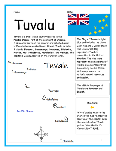
Introduce your learners to the island country of TUVALU in Oceania with two worksheets (plus answer key). Your students will read a brief introduction to Tuvalu (location, capital, flag, 9 islands, language), write ‘Vaiaku’ next to the star on the map to show the location of the capital, color the small map, and use the map and compass to answer 6 multiple-choice questions on page 2. Colored pencils and a pen or pencil are needed for this activity. No other prep needed. Basic Geography worksheet with a simple map to introduce the country of Tuvalu.
For use with Interactive Notebooks: After the worksheets are completed, students can cut out the map and flag and paste into the notebook under Oceania/Sub-Topic: Tuvalu. Under the map and flag, students can write a summary in their own words of what they now know about this country. Collect worksheets for other countries of Oceania to add to the notebook! Please browse this store for a selection of worksheets for other countries of Oceania (and beyond!).
Thank you so much for using my Geography worksheets in your classroom! I hope you find them useful. Reviews are welcome and very much appreciated!
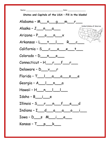
Fill in the blanks for the capital of each state of the USA! 3 printable worksheets (plus answer key)
Alabama - Montgomery
Alaska - Juneau
Arizona - Phoenix
Arkansas - Little Rock
California - Sacramento
Colorado - Denver
Connecticut - Hartford
Delaware - Dover
Florida - Tallahassee
Georgia - Atlanta
Hawaii - Honolulu
Idaho - Boise
Illinois - Springfield
Indiana - Indianapolis
Iowa - Des Moines
Kansas - Topeka
Kentucky - Frankfort
Louisiana - Baton Rouge
Maine - Augusta
Maryland - Annapolis
Massachusetts - Boston
Michigan - Lansing
Minnesota - St. Paul
Mississippi - Jackson
Missouri - Jefferson City
Montana - Helena
Nebraska - Lincoln
Nevada - Carson City
New Hampshire - Concord
New Jersey - Trenton
New Mexico - Santa Fe
New York - Albany
North Carolina - Raleigh
North Dakota - Bismarck
Ohio - Columbus
Oklahoma - Oklahoma City
Oregon - Salem
Pennsylvania - Harrisburg
Rhode Island - Providence
South Carolina - Columbia
South Dakota - Pierre
Tennessee - Nashville
Texas - Austin
Utah - Salt Lake City
Vermont - Montpelier
Virginia - Richmond
Washington - Olympia
West Virginia - Charleston
Wisconsin - Madison
Wyoming - Cheyenne
Introduce your learners to Papua New Guinea in Oceania with two worksheets (plus answer key). Your students will read a brief introduction to Papua New Guinea (location, capital, flag, islands, language), locate and circle Papua New Guinea on the map of Oceania, write ‘Port Moresby’ next to the star on the map of Papua New Guinea to show the location of the capital, color the small map, and use the maps and compass to answer 10 true/false questions on page 2. Colored pencils and a pen or pencil are needed for this activity. No other prep needed. Basic Geography worksheet with a simple map to introduce the country of Papua New Guinea and practice cardinal and ordinal directions.
For use with Interactive Notebooks: After the worksheets are completed, students can cut out the map and flag and paste into the notebook under Oceania/Sub-Topic: Papua New Guinea. Under the map and flag, students can write a summary in their own words of what they now know about this country. Collect worksheets for other countries of Oceania to add to the notebook! Please browse this store for a selection of worksheets for other countries of Oceania (and beyond!).
Thank you so much for using my Geography worksheets in your classroom! I hope you find them useful. Reviews are welcome and very much appreciated!
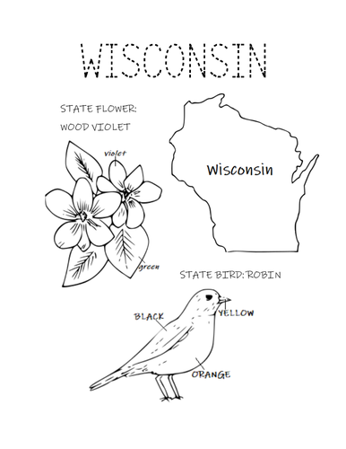
Print and color the state bird and flower of Wisconsin! State Bird: Robin. State Flower: Wood Violet. One printable coloring page.
Thank you so much for using my coloring pages! I hope you find them useful. Please browse this store for more coloring pages and Geography worksheets!
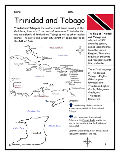
Introduce your learners to Trinidad and Tobago with two printable handouts (plus answer key). Your students will read a brief introduction to Trinidad and Tobago (location, capital, flag, language), write ‘Port of Spain’ next to the star on the map to show the location of the capital, locate and circle Trinidad and Tobago on the map of the Caribbean, color the map, and use the reading passage, maps and compass to answer 9 true/false questions on page 2. Colored pencils and a pen or pencil are needed for this activity. No other prep needed. Basic Geography worksheet with a simple map to introduce Trinidad and Tobago and practice cardinal and ordinal directions. Print and Go!
For use with Interactive Notebooks: After the worksheets are completed, students can cut out the map and flag and paste into the notebook under the topic of (example) The Caribbean / Sub-topic: Trinidad and Tobago. Under the map, your students can write a summary in their own words of what they now know about Trinidad and Tobago. Collect worksheets of other countries of the Caribbean to add to the notebook! All available in this store!
Thank you so much for using my Geography worksheets in your classroom! I hope you find them useful. Reviews are welcome and very much appreciated!
Included: Gulf of Paria, South America, United Kingdom
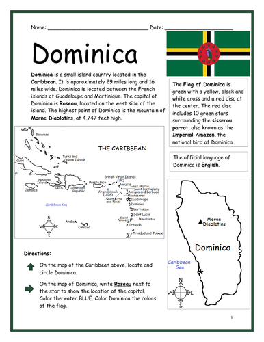
Introduce your learners to the island country of Dominica with two printable worksheets (plus answer key). Simple map activity and reading comprehension questions. Your students will read a brief introduction to Dominica (location, capital, flag, language), locate and circle Dominica on the map of the Caribbean (map 1), write ‘Roseau’ next to the star on the map of Dominica (map 2) to show the location of the capital, color the map, and use the reading passage, maps and compass to answer 10 true/false questions on page 2. Colored pencils and a pen or pencil are needed for this activity. No other prep needed. Basic Geography worksheet with a simple map to introduce Dominica and practice cardinal and ordinal directions. Print and Go!
For use with Interactive Notebooks: After the worksheets are completed, students can cut out the map and flag and paste into the notebook under the topic of (example) The Caribbean / Sub-topic: Dominica. Under the map, your students can write a summary in their own words of what they now know about Dominica. Collect worksheets of other countries of the Caribbean (or North America) to add to the notebook! All available in this store.
Thank you so much for using my Geography worksheets in your classroom! I hope you find them useful. Reviews are welcome and very much appreciated! Please browse this store for more worksheets to introduce your learners to the countries of the world!
Introduce your students to IRAQ with this printable handout of two worksheets (plus answer key). Your students will read a brief introduction to Iraq (location, capital, flag, language), write ‘Baghdad’ next to the star on the map to show the capital, color the small flag and map, and use the map and compass to answer 9 questions on page 2. Colored pencils and a pen or pencil are needed for this activity. No other prep needed. Basic Geography worksheet with a simple map to introduce Iraq and practice cardinal and ordinal directions.
For use with Interactive Notebooks: After the worksheets are completed, students can cut out the map and flag and paste into the notebook under the topic of Asia / Sub-Topic: Iraq. Under the map, students can write a summary in their own words of what they now know about this country. Collect worksheets for other countries of Asia to add to the notebook! Please browse this store for worsheets for all other countries of Asia (and beyond!).
Thank you so much for using my Geography worksheets in your classroom! I hope you find them useful. Reviews are welcome and very much appreciated!
Tigris River, Euphrates River, Cardinal, Ordinal directions.
Introduce your students to EQUATORIAL GUINEA with two worksheets (plus answer key). Your students will read a brief introduction to Equatorial Guinea (location, capital, flag, language), write ‘Malabo’ next to the star on the map to show the location of the capital, trace the dotted line to show the equator, color the small flag and map, and then use the map and compass to answer 8 questions on page 2. Pen or pencil and colored pencils needed for this activity. No other prep needed. Basic Geography worksheet with a simple map to introduce Equatorial Guinea and practice cardinal and ordinal directions.
For use with Interactive Notebooks: After the worksheets are completed, students can cut out the map and flag and paste into the notebook under the topic of Topic: Africa / Sub-Topic: Equatorial Guinea. (or Topic: Spanish-Speaking Countries / Sub-Topic: Equatorial Guinea). Under the map, your students can write a summary in their own words of what they now know about this country. Collect worksheets for other countries of Africa or Spanish-speaking countries to add to the notebook! Please browse this store for worksheets for other countries!
Thank you so much for using my Geography worksheets in your classroom! Reviews are welcome and very much appreciated.
Africa, Spanish, Gulf of Guinea, cardinal, ordinal directions.
Introduce your students to the United States of America with two worksheets (plus answer key). Your students will read a brief introduction to the United States (location, capital, flag, language, 13 original colonies), write ‘Washington D.C.’ next to the star on the map to show the location of the capital, color the small map, and use the map and compass to answer 10 questions on page 2.
Please note: This map includes the United States and surrounding, including Canada, Mexico, Atlantic Ocean, Pacific Ocean, Arctic Ocean, Gulf of Mexico, Cuba, Haiti, Dominican Republic, Puerto Rico. Individual states of America are not included on this map (except for Alaska, Hawaii and 13 original colonies). For worksheets to introduce your learners to each of the 50 states of the USA, please browse this store!
For use with Interactive Notebooks: After the worksheet is completed, students can cut out the map and flag and paste into the notebook under the topic of North America/Sub-Topic: United States. Under the map and flag, students can write a summary in their own words of what they now know about the United States of America! Collect worksheets for other countries of North America to add to the notebook! Please browse this store for worksheets to introduce your learners to countries of North America, such as Canada, Mexico, Cuba, Dominican Republic, Haiti, Puerto Rico, and countries of Central America!
Thank you so much for using my Geography worksheets in your classroom! I hope you find them useful. Reviews are welcome and very much appreciated.
Included: Washington D.C. formerly District of Columbia, named after first president and Founding Father George Washington.
Introduce your students to Bangladesh with this printable handout of two worksheets (plus answer key). Your students will read a brief introduction to Bangladesh (location, capital, flag, language), write ‘Dhaka’ next to the star on the map to show the location of the capital, color the small map and flag, and use the map and compass to answer 6 questions on page 2. Colored pencils and a pen or pencil are needed for this activity. No other prep needed. Basic Geography worksheet with a simple map to introduce Bangladesh and practice cardinal and ordinal directions.
For use with Interactive Notebooks: After the worksheets are completed, students can cut out the map and flag and paste into the notebook under the topic of Asia / Sub-topic: Bangladesh. Under the map and flag, students can write a summary in their own words of what they now know about this country. Collect worksheets for other countries of Asia to add to the notebook! Please browse this store for a selection of worksheets for countries of Asia (and beyond!)
Thank you for using my Geography worksheets in your classroom! I hope you find them useful. Reviews are welcome and very much appreciated!
Introduce your students to the U.S. state of Georgia with this printable handout of two worksheets (plus answer key). Your students will read a brief introduction to Georgia (location, capital, flag, state bird and flower), write ‘Atlanta’ next to the star on the map to show the location of the capital, color the small map, state bird and flower, and use the map and compass to answer 7 questions on page 2. Colored pencils and a pen or pencil are needed for this activity. No other prep needed. Basic Geography worksheet with a simple map to introduce the state of Georgia and practice cardinal and ordinal directions.
For use with Interactive Notebooks: After the worksheets are completed, students can cut out the map, flag, state bird and state flower, and paste into the notebook under the topic of United States / Sub-Topic: Georgia. Under the map, students can write a summary in their own words of what they now know about this state. Collect worksheets for all U.S. states to add to notebook! Please browse this store for a selection of worksheets for other states of the USA (and beyond!)
Thank you so much for using my Geography worksheets in your classroom! I hope you find them useful. Reviews are welcome and very much appreciated.
Introduce your students to the country of GEORGIA with this printable handout of two worksheets (plus answer key). Your students will read a short introductory passage about Georgia (location, capital, flag, language), write ‘Tbilisi’ next to the star on the map to show the location of the capital, color the small map and flag, and use the map and compass to answer 7 questions on page 2. Colored pencils and a pen or pencil are needed for this activity. No other prep needed. Basic Geography worksheet with a simple map to introduce the country of Georgia and practice cardinal and ordinal directions.
For use with Interactive Notebooks: After completing the worksheets, students can cut out the map and flag and paste it into the notebook under the topic of Europe (or Asia or Eurasia) / Sub-Topic: Georgia. Under the map and flag, students can write a summary in their own words of what they now know about the country of Georgia. Collect worksheets for other countries to add to the notebook! Please browse this store for a selection of worksheets for other countries of Europe, Asia, and beyond!
Thank you so much for using my Geography worksheets in your classroom! Reviews are welcome and very much appreciated.
Caucasus region, Black Sea, Caspian Sea, cardinal and ordinal directions.
Introduce your students to PORTUGAL with two worksheets (plus answer key). Your students will read a brief introduction to Portugal (location, capital, flag, language), write ‘Lisbon’ next to the star on the map to show the location of the capital, color the small flag and map, and use the map and compass to answer 6 questions on page 2. Colored pencils and a pen or pencil are needed for this activity. No other prep needed. Basic Geography worksheet with a simple map to introduce Portugal and practice cardinal and ordinal directions.
For use with Interactive Notebooks: After completing the worksheets, students can cut out the map and flag and paste into the notebook under the topic of Europe / Sub-Topic: Portugal. Under the map and flag, students can write a summary in their own words of what they now know about this country. Collect worksheets for other countries of Europe to add to the notebook! Please browse this store for worksheets for other countries of Europe (and beyond!).
Thank you so much for using my Geography worksheets in your classroom. I hope you find them useful! Reviews are welcome and very much appreciated.
Introduce your learners to CROATIA in Europe with two worksheets (plus answer key). Your students will read a brief introduction to Croatia (location, capital, flag, language), write ‘Zagreb’ next to the star on the map to show the capital, color the small map, and use the map and compass to answer 7 questions on page 2. Colored pencils and a pen or pencil are needed for this activity. No other prep needed. Basic Geography worksheet with a simple map to introduce the country of Croatia and practice cardinal and ordinal directions.
For use with Interactive Notebooks: After completing the worksheets, students can cut out the map and flag of Croatia and paste into the notebook under the topic of Europe / Sub-Topic: Croatia. Under the map and flag, students can write a summary in their own words of what they now know about this country. Collect worksheets for other countries of Europe to add to the notebook! Please browse this store for a selection of worksheets for other countries of Europe (and beyond!)
Thank you so much for using my Geography worksheets in your classroom! I hope you find them useful. Reviews are welcome and very much appreciated.
Map includes: Adriatic Sea, Slovenia, Hungary, Austria, Serbia, Bosnia and Herzegovina, Montenegro, Italy
Flag includes Coat of arms: šahovnica. 5 Croatian regions: Croatia, Dubrovnik, Dalmatia, Istria, and Slavonia.