Thank you for visiting! Here you will find a selection of printable, interactive worksheets for your classroom: Basic Geography worksheets with simple maps, ESL, Spanish, Bible, Reading Comprehension and more. I hope you find the resources useful! Reviews are welcome and very much appreciated. Thank you so much.
Thank you for visiting! Here you will find a selection of printable, interactive worksheets for your classroom: Basic Geography worksheets with simple maps, ESL, Spanish, Bible, Reading Comprehension and more. I hope you find the resources useful! Reviews are welcome and very much appreciated. Thank you so much.
Introduce your learners to the 9 African Great Lakes with this free printable map and word search puzzle! Using the map, find the 9 African Great Lakes in the Word Search Puzzle. Lakes to find: TURKANA, VICTORIA, TANGANYIKA, RUKWA, MALAWI, MWERU, KIVU, EDWARD, ALBERT. One printable handout plus answer key.
If you’d like to introduce your learners to the 10 COUNTRIES of the African Great Lakes region, do so one country at a time with a printable worksheet for each country! Countries included: Burundi, Democratic Republic of the Congo, Ethiopia, Kenya, Malawi, Mozambique, Rwanda, Tanzania, Uganda, Zambia. Worksheets available individually or as a discounted bundle! Please click on this link for more info: https://www.tes.com/teaching-resource/african-great-lakes-region-countries-introductory-worksheets-bundle-12777435
Thank you for using my Geography worksheets! I hope you find them useful. Reviews are welcome and very much appreciated! Please browse this store for a selection of printable worksheets to introduce your learners to the countries of the world!
Teach your students about Cuba with this printable handout of 2 worksheets (plus answer key). Your students will read a brief overview of Cuba (location, capital, flag), write ‘Havana’ next to the star on the map to show the capital, then colour the flag and map of Cuba and surrounding. Then they will use the map and compass to answer 5 multiple-choice questions on page 2.
Four use with Interactive Notebooks: After the handout is completed and the map and flag are coloured, cut out the map, flag and compass and paste into the notebook under the topic of CUBA. Under the map, your students will write a summary in their own words of what they now know about Cuba.
Thank you four using my Geography worksheets in your classroom!
Cuba and surrounding: Jamaica, Haiti, Dominican Republic, Mexico, Belize, Guatemala, Honduras, United States, Florida, the Bahamas, Caribbean Sea, Atlantic Ocean, Gulf of Mexico. North America, Central America. Cardinal, ordinal directions. Isla dae la Juventud.
Note: This handout is in British English. For American English, please visit this link:
In Fudge-A-Mania by Judy Blume, Peter Hatcher’s family will be driving from Manhattan, NY to Southwest Harbor, ME for their summer vacation. On the map, your students will write ‘Manhattan’ next to the star on the map in New York to show where Peter lives, then write ‘Southwest Harbor’ next to the star on the map in Maine to show where the family will be vacationing. Then they will draw a line from Manhattan to Southwest Harbor to show the journey they will travel. On page 2, your students will use the map and compass to answer three questions:
What three states will the Hatchers have to drive through to get to Maine?
In what direction will the Hatchers have to drive to get from New York to Maine?
Southwest Harbor is on the coast of what ocean?
This geography/reading comprehension activity can be done after reading chapters 1-2 of Fudge-A-Mania. This includes two printable handouts.
If you are interested in using the full packet for ‘Fudge-A-Mania’ or ‘Tales of a Fourth Grade Nothing’ which include handouts for each chapter (cloze exercises, fill-in-the-blank, matching activities and crossword puzzles) for reading comprehension and vocabulary building, please visit the link to my shop: https://www.tes.com/teaching-resources/shop/tspeelman.
Thank you for using this resource! Reviews are welcome and very much appreciated.
Introduce your students to the SOUTHWEST REGION of the United States with this free printable handout of one page (plus answer key). Using the map of the Southwest Region, find the four states of the region in the word search puzzle: Arizona, New Mexico, Texas, Oklahoma.
Other regions also available! Please check out this store for:
-SOUTHEAST REGION MAP AND WORD SEARCH
-NORTHEAST REGION MAP AND WORD SEARCH
-MIDWEST REGION MAP AND WORD SEARCH
-WEST REGION MAP AND WORD SEARCH
Thank you so much for using my Geography worksheets in your classroom!
Introduce your learners to Bear Lake on the border of Idaho and Utah in the United States with this printable handout of two worksheets (plus answer key). Your students will read a brief overview of Bear Lake, trace the line to separate Idaho and Utah, color the small map, and use the map and compass to answer 7 True/False questions on page 2. Colored pencils and a pen or pencil are needed for this activity. No other prep needed. Basic Geography worksheet with a simple map to introduce Bear Lake and practice cardinal and ordinal directions.
Also available:
IDAHO - Printable worksheet with map and flag
UTAH - Printable worksheet with map and flag
For use with Interactive Notebooks: After the worksheets are completed, students can cut out the map of Bear Lake and paste into the notebook under the topic of United States / Sub-Topic: Bear Lake. Under the map, students can write a summary in their own words of what they now know about Bear Lake. Collect worksheets for states of the US and more to add to the notebook! Please browse this store for a selection of printable worksheets for other states of the USA and more!
Thank you so much for using my worksheets in your classroom! Reviews are welcome and very much appreciated!
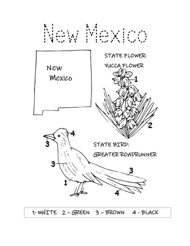
Print and color the state bird and flower of New Mexico! State Bird: Greater Roadrunner. State Flower: Yucca Flower. One printable coloring page.
Thank you so much for using my printable coloring pages in your classroom! Reviews are welcome and very much appreciated. Please browse this store for other printable worksheets and coloring pages.
Introduce your learners to the U.S. state of Connecticut with this printable handout of two worksheets (plus answer key). Your students will read a brief overview of Connecticut (location, capital, flag, state bird, state flower), write ‘Hartford’ next to the star on the map to show the location of the capital, color the small map, state bird and state flower, and use the map and compass to answer 10 true/false questions on page 2. Colored pencils and a pen or pencil are needed for this activity. No other prep needed. Basic Geography worksheet with a simple map to introduce the state of Connecticut and practice cardinal and ordinal directions.
For use with Interactive Notebooks: After the worksheets are completed, students can cut out the map, flag, state bird and state flower of Connecticut and paste into the notebook under the topic of United States/Sub-Topic: Connecticut. Under the map, students can write a summary in their own words of what they now know about this state. Collect worksheets for other states of the US to add to the notebook! Please browse this store for a selection of worksheets for other states of the USA (and beyond!).
Thank you so much for using my worksheets in your classroom! Reviews are welcome and very much appreciated!
Included: Rhode Island, Massachusetts, New York, Long Island, Long Island Sound, 13 original colonies, 1636, Bridgeport, American Robin, Mountain-laurel.
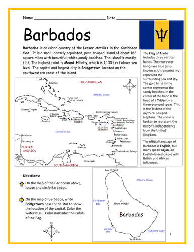
Introduce your learners to BARBADOS with two printable worksheets (plus answer key). Simple map activity and reading comprehension activity. No prep needed. Print and go!
Your students will read a brief introduction to Barbados (location, capital, flag, language), write ‘Bridgetown’ next to the star on the map to show the location of the capital, color the map, and use the reading passage, maps and compass to answer 10 true/false questions on page 2. Colored pencils and a pen or pencil are needed for this activity. No other prep needed. Basic Geography worksheet with a simple map to introduce Barbados and practice cardinal and ordinal directions.
For use with Interactive Notebooks: After the worksheets are completed, students can cut out the map and flag and paste into the notebook under the topic of (example) The Caribbean / Sub-topic: Barbados. Under the map, your students can write a summary in their own words of what they now know about Barbados. Collect worksheets of other countries of the Caribbean to add to the notebook! All available in this store!
Thank you so much for using my Geography worksheets in your classroom! I hope you find them useful. Reviews are welcome and very much appreciated. Please browse this store for more printable handouts with simple maps to introduce your learners to the countries of the world!
Sped, homeschool, homework, resource room teacher, independent learning, elementary, primary.
Included: Lesser Antilles, Mount Hillaby.
Introduce your students to the 12 counties of Albania with this simple map and Word Search Puzzle activity!
Directions: Using the map of Albania, locate the 12 counties in the Word Search Puzzle. They can be found forward or backward. Answer key included. Counties to find: Berat, Dibër, Durrës, Elbasan, Fier, Gjirokastër, Korcë, Kukës, Lezhë, Shkodër, Tirana, and Vlorë.
One printable word search puzzle with map (plus answer key). Instant download. Print and go!
Thank you so much for using this Geography Word Search Puzzle in your classroom! I hope you find it useful. Reviews are welcome and very much appreciated. Please browse this site for more printable worksheets with simple maps to introduce your learners to the countries of the world!
Introduce your students to the state of ALASKA with two printable worksheets (plus answer key). Simple map activity and reading comprehension questions. Answer key included. Instant download. Print and Go!
Your students will read a brief introduction to Alaska (location, capital, flag, state bird, state flower), write ‘Juneau’ next to the star on the map to show the location of the capital, color the map, flag, state bird and flower, and use the map and compass to answer 8 questions on page 2. Colored pencils and a pen or pencil are needed for this activity. No other prep needed. Basic Geography worksheet with a simple map to introduce Alaska and practice cardinal and ordinal directions.
For use with Interactive Notebooks: After the worksheets are completed, students can cut out the map and flag, state bird and flower, and paste into the notebook under the topic of (example) 50 States of the USA / Sub-Topic: Alaska. Under the map, students can write a summary in their own words of what they now know about this state. Collect worksheets for other U.S. states or countries of North America to add to notebook! Please browse this site for a selection of printable worksheets with simple maps to introduce your learners to the countries and states of the world!
Thank you so much for using my Geography worksheets in your classroom! I hope you find them useful. Reviews are welcome and very much appreciated.
State bird: Willow Ptarmigan
State flower: Alpine Forget-Me-Not
Introduce your students to the North Pole with this printable handout of two worksheets (plus answer key). Simple map activity and reading comprehension questions. Print and go!
Your students will read a brief introduction to the North Pole, trace the line of the Arctic Circle, color the map of the North Pole and surrounding (map includes parts of the Arctic Ocean, Russia, Canada, Alaska, Greenland, Iceland, Norway, Sweden, Finland, Pacific Ocean, Atlantic Ocean) and use the map to answer 5 questions on page 2.
Thank you so much for using my printable worksheets. I hope you find them useful!
Introduce your students to the island country of São Tomé and Príncipe in Africa with two worksheets (plus answer key). Instant download. Print and go!
Your students will read a brief introduction to São Tomé and Príncipe (location, capital, flag, language), write ‘São Tomé’ next to the star on the map to show the location of the capital, trace the line of the equator, color the small map, and use the map and compass to answer 8 questions on page 2. Colored pencils and a pen or pencil are needed for this activity. No other prep needed. Basic Geography worksheet with a simple map to introduce São Tomé and Príncipe and practice cardinal and ordinal directions.
For use with Interactive Notebooks: After the worksheets are completed, students can cut out the map and flag and paste into the notebook under the topic of (example) Countries of Africa/Sub-topic: São Tomé and Príncipe. Under the map and flag, your students can write a summary in their own words of what they now know about this country. Collect worksheets for other countries of Africa to add to the notebook! All available in this store!
Thank you so much for using my Geography worksheets in your classroom. I hope you find them useful. Reviews are welcome and very much appreciated.
Rôlas, Caroço, Tinhosas, Portuguese
Introduce your students to Suriname, the smallest country in South America, with this black & white printable handout of two worksheets (plus answer key).
Instant download. Print and go!
Your students will read a brief introduction to Suriname (location, capital, flag, language), write ‘Paramaribo’ next to the star on the map to show the location of the capital, color the map and flag, and use the map and compass to answer 6 questions on page 2. Colored pencils and a pen or pencil are needed for this activity. No other prep needed. Basic Geography worksheet with a simple map to introduce the country of Suriname and practice cardinal and ordinal directions.
For use with Interactive Notebooks: After the worksheet is completed, students can cut out the map and flag and paste into the notebook under the topic of (example) Countries of South American / Sub-Topic: Suriname. Under the map and flag, students can write a summary in their own words about what they know about this country. Collect worksheets of other countries of South America to add to this notebook. All available in this store!
Please note this worksheet prints in black and white. (1) For easy printing, and (2) so students can do all of the the coloring! For more worksheets in black in white (or color) to introduce your learners to countries of South America and around the world, please browse this store!
Thank you so much for using this worksheet in your classroom! I hope you find them useful. Reviews are welcome and very much appreciated.
SPED, resource room teacher, third grade, homework, independent learning.
Introduce your learners to the island country of Vanuatu in Oceania with two printable worksheets (plus answer key). Instant download. Print and go!
Your students will read a brief introduction to Vanuatu (location, capital, flag, islands, language), write ‘Port Vila’ next to the star on the map to show the location of the capital, color the small map, and use the map and compass to answer 10 true/false questions on page 2. Colored pencils and a pen or pencil are needed for this activity. No other prep needed. Basic Geography worksheet with a simple map to introduce Vanuatu and practice cardinal and ordinal directions.
For use with Interactive Notebooks: After the worksheets are completed, students can cut out the map and flag and paste into the notebook under (example) Oceania / Sub-Topic: Vanuatu. Under the map and flag, students can write a summary in their own words of what they now know about this country. Collect worksheets for other countries of Oceania to add to the notebook! All available in this store.
Thank you so much for using my Geography worksheets in your classroom! I hope you find them useful. Reviews are welcome and very much appreciated!
Pacific Ocean, Mount Tabwemasana, Espiritu Santo, Efate, Malakula.
Fill in the blank letters for each state of the United States. 1 printable handout (plus answer key).
Alabama, Alaska, Arizona, Arkansas. California, Colorado, Connecticut, Delaware, Florida, Georgia, Hawaii, Idaho, Illinois. Indiana. Iowa. Kansas, Kentucky, Louisiana, Maine, Maryland. Massachusetts. Michigan. Minnesota, Mississippi, Missouri. Montana, Nebraska, Nevada, New Hampshire, New Jersey, New Mexico, New York, North Carolina, North Dakota, Ohio, Oklahoma, Oregon. Pennsylvania, Rhode Island, South Carolina, South Dakota, Tennessee, Texas, Utah, Vermont, Virginia, Washington, West Virginia, Wisconsin, Wyoming
Introduce your students to the country of INDONESIA with this printable handout of two worksheets (plus answer key). Your students will read a brief introduction to Indonesia (location, capital, language, flag), write ‘Jakarta’ next to the star on the map to show the location of the capital, trace the line of the equator, color the small map, and use the map and compass to answer 7 multiple-choice questions on page 2. Colored pencils and a pen or pencil are needed for this activity. No other prep needed. Basic Geography worksheet with a simple map to introduce Indonesia in Asia.
For use with Interactive Notebooks: After the worksheets are completed, students can cut out the map and flag and paste into the notebook under the topic Asia/Sub-topic: Indonesia. Under the map, your students can write a summary in their own words of what they now know about this country. Collect worksheets for other countries of Asia to add to the notebook! Please browse this store for a selection of worksheets for all other countries of Asia (and beyond!).
Thank you so much for using my Geography worksheets in your classroom! I hope you find them useful. Reviews are welcome and very much appreciated.
Included: Indian Ocean, Pacific Ocean, Java, Sumatra, Borneo, Sulawesi, New Guinea, Malaysia.
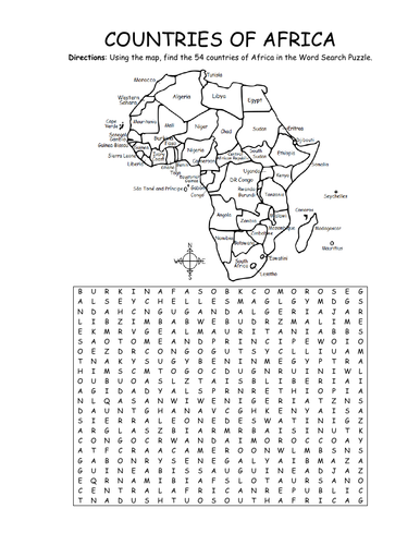
Using the map, find the 54 countries of Africa in this printable Word Search Puzzle! One printable word search puzzle with map (plus answer key).
Countries to find: ALGERIA, ANGOLA, BENIN, BOTSWANA, BURKINA FASO, BURUNDI, CAMEROON, CAPE VERDE, CENTRAL AFRICAN REPUBLIC, CHAD, COMOROS, DJIBOUTI, ESWATINI, GABON, KENYA, EGYPT, EQUATORIAL GUINEA, ERITREA, ETHIOPIA, DR CONGO, CONGO, THE GAMBIA, GHANA, GUINEA, GUINEA-BISSAU, IVORY COAST, LESOTHO, LIBERIA, LIBYA, MADAGASCAR, MALAWI, MALI, MAURITANIA, MAURITIUS, MOROCCO, MOZAMBIQUE, NAMIBIA, NIGER, NIGERIA, RWANDA, SAO TOME AND PRINCIPE, SENEGAL, SEYCHELLES, SIERRA LEONE, SOMALIA, SOUTH AFRICA, SOUTH SUDAN, SUDAN, TANZANIA, TOGO, TUNISIA, UGANDA, WESTERN SAHARA, ZIMBABWE
To introduce your learners to each country of Africa, please browse this store for printable worksheets!
Thank you so much for using my Geography worksheets in your classroom! I hope you find them useful. Reviews are welcome and very much appreciated.
Introduce your students to French Guiana with this printable handout of 2 worksheets (plus answer key). Your students will read a brief overview of French Guiana (location, capital, language, flag), write 'Cayenne' next to the star on the map to show the capital, color a small map and flag, and use the map and compass to answer 6 questions. Basic Geography worksheet with a simple map to introduce French Guiana and practice cardinal and ordinal directions.
For use with Interactive Notebooks: After the handout is completed, students can cut out the map and flag and paste into the notebook under the topic South America/Sub-Topic: French Guiana. Under the map, your students can write a summary in their own words of what they now know about French Guiana. Collect handouts for other countries of South America to add to the notebook. Please browse this store for a selection of printable handouts of other countries of South America (and beyond!).
Thank you so much for using my Geography worksheets in your classroom! Reviews are welcome and very much appreciated.
Introduce your learners to Albania in Europe with this printable handout of two worksheets (plus answer key). Your students will read a brief introduction to Albania (location, capital, flag, language), write ‘Tirana’ next to the star on the map to show the location of the capital, color the small map, and use the map and compass to answer 7 questions on page 2. Colored pencils and a pen or pencil are needed for this activity. No other prep needed. Basic Geography worksheet with a simple map to introduce Albania and practice cardinal and ordinal directions.
For use with Interactive Notebooks: After completing the worksheets for Albania, students can cut out the map and flag and paste into the notebook under the topic of Europe / Sub-Topic: Albania. Under the map and flag, students can write a summary in their own words of what they now know about this country. Collect worksheets for other countries of Europe to add to the notebook! Please browse this store for a selection of worksheets for other countries of Europe (and beyond!).
Thank you so much for using my Geography worksheets in your classroom! I hope you find them useful and fun. Reviews are welcome and very much appreciated. :)
Introduce your learners to the state of Nebraska with this printable handout of two worksheets (plus answer key). Your students will read a brief overview of Nebraska (location, capital, flag, state bird, state flower), write ‘Lincoln’ next to the star on the map to show the location of the capital, color the small map, state bird and state flower, and use the map and compass to answer 10 true/false questions on page 2. Colored pencils and a pen or pencil are needed for this activity. No other prep needed. Basic Geography worksheet with a simple map to introduce the state of Nebraska and practice cardinal and ordinal directions.
For use with Interactive Notebooks: After the worksheets are completed, students can cut out the map, flag, state bird and state flower of Nebraska and paste into the notebook under the topic of United States/Sub-Topic: Nebraska. Under the map, students can write a summary in their own words of what they now know about this state. Collect worksheets for other states of the US to add to the notebook! Please browse this store for a selection of worksheets for other states of the USA (and beyond!).
Thank you so much for using my worksheets in your classroom! Reviews are welcome and very much appreciated!
Included: Midwestern region of the United States, South Dakota, Iowa, Missouri, Kansas, Colorado, Wyoming, Omaha, Western Meadowlark, Tall Goldenrod, State Motto: Equality before the Law. Missouri River.