Thank you for visiting! Here you will find a selection of printable, interactive worksheets for your classroom: Basic Geography worksheets with simple maps, ESL, Spanish, Bible, Reading Comprehension and more. I hope you find the resources useful! Reviews are welcome and very much appreciated. Thank you so much.
Thank you for visiting! Here you will find a selection of printable, interactive worksheets for your classroom: Basic Geography worksheets with simple maps, ESL, Spanish, Bible, Reading Comprehension and more. I hope you find the resources useful! Reviews are welcome and very much appreciated. Thank you so much.
Mexico is located south of the United States and north of Central America. Introduce your learners to Mexico and surrounding with this printable map activity! Two worksheets (plus answer key).
Page 1:
FILL IN THE BLANKS on the map for each of the following: Alabama, Arizona, Arkansas, Atlantic Ocean, Belize, California, Caribbean Sea, Costa Rica, Cuba, El Salvador, Florida, Georgia, Guatemala, Gulf of Mexico, Honduras, Louisiana, Mexico, Mississippi, New Mexico, Nicaragua, Oklahoma, Pacific Ocean, Panama, South Carolina, Texas.
COLOR CODE: Choose a color for the United States, Mexico, Central America, and Bodies of Water. Then color the map.
Page 2: Use your completed map and compass to answer 7 questions.
Page 3: Answer Key.
Colored pencils and a pen or pencil are needed for this activity. No other prep needed.
Thank you so much for using my printables with your learners! I hope you find them useful. Reviews are welcome and very much appreciated. Please browse this store for more worksheets to introduce your learners to the countries of the world!
This printable handout of one page includes a map of South America. Your students will write each country of South America on the map, using the list of countries to fill in the blanks: Argentina, Bolivia, Brazil, Chile, Colombia, Ecuador, French Guiana, Guyana, Paraguay, Peru, Suriname, Uruguay, and Venezuela, as well as the Pacific Ocean and Atlantic Ocean. Then your students can color the map. Colored pencils or crayons and a pen or pencil are needed for this activity. No other prep needed.
Introduce your students to North Korea with this printable handout of 2 worksheets (plus answer key). Your students will read a brief introduction to North Korea (location, capital, flag, language), write 'Pyongyang’ next to the star on the map to show the location of the capital, write DMZ on the border of North and South Korea to show the location of the Korean Demilitarized Zone, color the small flag and map, and use the map and compass to answer 9 questions on page 2. Colored pencils and a pen or pencil are needed for this activity. No other prep needed. Basic Geography worksheet with a simple map to introduce North Korea.
For use with Interactive Notebooks: After the worksheets are completed, students can cut out the map and flag and paste into the notebook under the topic of Asia/Sub-Topic: North Korea. Under the map, students can write a summary in their own words of what they now know about North Korea. Collect handouts for other countries of Asia to add to the notebook! Please browse this store for a selection of printable handouts for other countries of Asia (and beyond!).
Thank you so much for using my Geography worksheets in your classroom! I hope you find them useful. Reviews are welcome and very much appreciated! Please browse this store for worksheets with simple maps to introduce your learners to the countries of the world!
Teach your students about KOREA with this printable handout of two worksheets (plus answer key). Your students will read a brief overview of Korea (located in East Asia, consists of North and South Korea, bordered by China, Russia, and Japan and surrounded by the Sea of Japan, Yellow Sea, Korea Bay, and Korea Strait). Your students will color a small map of Korea and surrounding area and then use the map and compass to answer five questions.
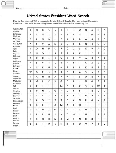
Find the last names of U.S. presidents in the Word Search puzzle with this printable worksheet (1 page plus answer key). The names can be found forward or backward. Then write the remaining letters on the lines below for an interesting fact about a U.S. president.
Leftover letters will spell out: Franklin D. Roosevelt was the first president to appear on the TV.
List of last names included to find in puzzle: Washington, Adams, Jefferson, Madison, Monroe, Jackson, Van Buren, Harrison, Tyler, Polk, Taylor, Fillmore, Pierce, Buchanan, Lincoln, Johnson, Grant, Hayes, Garfield , Arthur, Cleveland, McKinley, Roosevelt, Taft, Wilson, Harding, Coolidge, Hoover, Truman, Eisenhower, Kennedy, Nixon, Ford, Carter, Reagan, Bush, Clinton, Obama, Trump, Biden.
Thank you so much for using my worksheets in your classroom! Please browse this store for a selection of other worksheets for the USA (and beyond)!
Introduce your learners to CYPRUS with this two printable worksheets (plus answer key). Your students will read a brief introduction to Cyprus (location, capital, flag, language), write ‘Nicosia’ next to the star on the map to show the capital, color a small map (Island of Cyprus, UN Buffer Zone, Turkish Republic of Northern Cyprus, Republic of Cyprus, Mediterranean Sea), and use the map and compass to answer 9 questions on page 2. Colored pencils and a pen or pencil are needed for this activity. No other prep needed. Basic Geography worksheet with a simple map to introduce the country of Cyprus and practice cardinal and ordinal directions.
For use with Interactive Notebooks: After completing the worksheets, students can cut out the map and flag of Cyprus and paste into the notebook under the topic of Europe (or Asia or the Middle East)/Sub-Topic: Cyprus. Under the map and flag, students can write a summary in their own words of what they now know about this country. Collect worksheets for other countries of Europe, Asia, or the Middle East to add to the notebook! Please browse this store for worksheets for other countries of Europe, Asia, the Middle East (and beyond!).
Thank you for using my Geography worksheets in your classroom! I hope you find them useful. Reviews are welcome and very much appreciated!
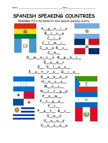
Fill in the blanks for each Spanish-speaking country using the list of countries on page 2. Countries included: Argentina, Bolivia, Chile, Colombia, Costa Rica, Cuba, Dominican Republic, Ecuador, El Salvador, Equatorial Guinea, Guatemala, Honduras, Mexico, Nicaragua, Panama, Paraguay, Peru, Puerto Rico, Spain, Uruguay, Venezuela.
For individual worksheets to introduce each Spanish-speaking country, please browse this store! Basic Geography worksheets with simple maps.
Thank you so much for using my worksheets in your classroom! I hope you find them useful. Reviews are welcome and very much appreciated!
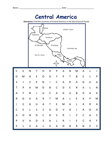
Introduce your students to the countries of Central America with this printable Word Search Puzzle! Using the map of Central America, find the 7 countries in the Word Search Puzzle: Guatemala, Belize, Honduras, El Salvador, Nicaragua, Costa Rica, and Panama.
Please browse this store for a selection of Geography worksheets to introduce your learners to the countries of Central America (and beyond!) Thank you for using my worksheets in your classroom! I hope you find them useful. Reviews are welcome and very much appreciated!
Introduce your learners to QATAR with this printable handout of two worksheets (plus answer key). Your students will read a brief introduction to Qatar (location, capital, language, flag), write ‘Doha’ next to the star on the map to show the capital, color the small map, and use the map and compass to answer 8 questions on page 2. Colored pencils and a pen or pencil are needed for this activity. No other prep needed. Basic Geography worksheet with a simple map to introduce Qatar and practice cardinal/ordinal directions.
For use with Interactive Notebooks: After the worksheets are completed, students can cut out the map and flag and paste into the notebook under the topic of Asia or Middle East / Sub-topic: Qatar. Under the map, students can write a summary in their own words of what they now know about this country. Collect handouts for other countries of Asia or Middle East to add to the notebook! Please browse this store for a selection of printable Geography worksheets for other countries of the Middle East, Asia (and beyond!).
Thank you so much for using my Geography worksheets in your classroom! I hope you find them useful. Reviews are welcome and very much appreciated! Please browse this store for a selection of worksheets to introduce your students to the countries of the world!
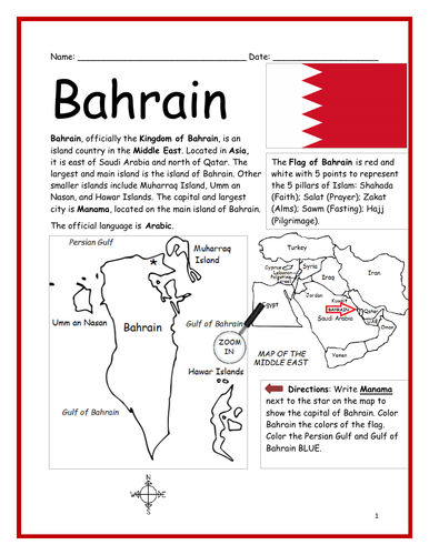
Introduce your learners to the country of Bahrain with this printable handout of two worksheets (plus answer key). Your students will read a brief introduction to Bahrain (location, capital, language, flag), write ‘Manama’ next to the star on the map to show the capital, color the small map, and use the map and compass to answer 8 questions on page 2. Colored pencils and a pen or pencil are needed for this activity. No other prep needed. Basic Geography worksheet with a simple map to introduce Bahrain and practice cardinal/ordinal directions.
For use with Interactive Notebooks: After your students complete the worksheets, they can cut out the map and flag and paste into the notebook under the topic of Asia or Middle East / Sub-topic: Bahrain. Under the map, students can write a summary in their own words of what they now know about this country. Collect handouts for other countries of Asia or Middle East to add to the notebook! Please browse this store for a selection of worksheets for other countries of the Middle East, Asia, and beyond!
Thank you for using my worksheets in your classroom! I hope you find them useful. Reviews are welcome and very much appreciated!
Introduce your learners to Washington D.C. - the capital of the United States of America, with this printable handout of two worksheets (plus answer key). Your students will read a brief overview of Washington D.C., write ‘White House’ next to the star on the map to show the location of the White House, color the small map, and answer 8 True/False questions on page 2. Colored pencils and a pen or pencil are needed for this activity. No other prep needed. Basic Geography worksheet with a simple map to introduce Washington D.C.
For use with Interactive Notebooks: After the worksheets are completed, students can cut out the map and flag of Washington D.C. and paste into the notebook under the topic of United States / Sub-Topic: Washington D.C… Under the map, students can write a summary in their own words of what they now know about Washington D.C. Collect worksheets for all U.S. states to add to notebook! Please browse this store for a selection of printable Geography worksheets for all states of the USA (and beyond!).
Thank you so much for using my Geography worksheets in your classroom! I hope you find them useful. Reviews are welcome and very much appreciated.
District of Colombia, Potomac River, Virginia, Maryland. State Bird and State Flower. Wood Thrush. American Beauty Rose
Introduce your learners to the state of California in the USA with this printable handout of two worksheets (plus answer key). Your students will read a brief introduction to California (location, capital, flag, state bird, state flower), write ‘Sacramento’ next to the star on the map to show the capital, color the small map, and use the map and compass to answer 8 questions on page 2. Colored pencils and a pen or pencil are needed for this activity. No other prep needed. Basic Geography worksheet with a simple map to introduce California and practice cardinal and ordinal directions.
For use with Interactive Notebooks: After the worksheets are completed, students can cut out the map and flag of California and paste into the notebook under the topic of United States / Sub-Topic: California. Under the map, students can write a summary in their own words of what they now know about this state. Collect worksheets for states of the US and more to add to the notebook! Please browse this store for a selection of printable worksheets for other states of the USA (and beyond!).
Thank you for using my Geography worksheets in your classroom! I hope you find them useful. Reviews are welcome and very much appreciated.
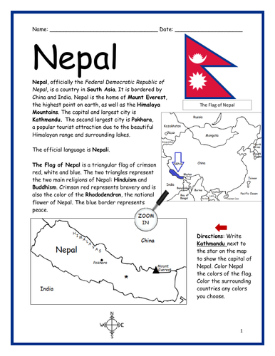
Introduce your learners to the country of Nepal in Asia with this printable handout of two worksheets (plus answer key). Your students will read a brief introduction to Nepal (location, capital, language, flag), write ‘Kathmandu’ next to the star on the map to show the location of the capital, color the small map, and use the map and compass to answer 8 multiple-choice questions on page 2. Colored pencils and a pen or pencil are needed for this activity. No other prep needed. Basic Geography worksheet with a simple map to introduce Nepal and practice cardinal/ordinal directions.
For use with Interactive Notebooks: After your students complete the worksheets, they can cut out the map and flag and paste into the notebook under the topic of Asia / Sub-topic: Nepal. Under the map, students can write a summary in their own words of what they now know about this country. Collect worksheets for other countries of Asia to add to the notebook! Please browse this store for a selection of printable worksheets for other countries of Asia (and beyond!).
Thank you for using my Geography worksheets in your classroom! I hope you find them useful. Reviews are welcome and very much appreciated!
Included: China, India, Mount Everest, Himalayas, Pokhara, Rhododendron
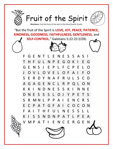
Find each FRUIT OF THE SPIRIT in the Word Search Puzzle: love, joy, peace, patience, kindness, goodness, faithfulness, gentleness, and self-control.
Bible Verse: “But the fruit of the Spirit is love, joy, peace, patience, kindness, goodness, faithfulness, gentleness, and self-control.” Galatians 5:22-23 (CEB).
Thank you so much for using my printable Bible worksheets! Please browse this store for a selection of other printable Bible worksheets for the Fruits of the Spirit and more!
Introduce your learners to United Arab Emirates in the Middle East and Asia with this printable handout of two worksheets (plus answer key). Your students will read a brief introduction to UAE (location, capital, language, flag), write ‘Abu Dhabi’ next to the star on the map to show the location of the capital, color the small map, and use the map and compass to answer 9 questions on page 2. Colored pencils and a pen or pencil are needed for this activity. No other prep needed. Basic Geography worksheet with a simple map to introduce UAE and practice cardinal/ordinal directions.
For use with Interactive Notebooks: After your students complete the worksheets, they can cut out the map and flag of UAE and paste into the notebook under the topic of Asia or Middle East / Sub-topic: United Arab Emirates. Under the map, students can write a summary in their own words of what they now know about this country. Collect worksheets for other countries of Asia or the Middle East to add to the notebook! All available in this store. Please browse this store for a selection of printable worksheets for other countries of Asia, the Middle East, and beyond!
Thank you so much for using my Geography worksheets in your classroom! I hope you find them useful. Reviews are welcome and very much appreciated.
Included: Persian Gulf, Gulf of Oman, Arabian Peninsula, maritime borders, Arabic, Pan-Arab colors, 7 emirates
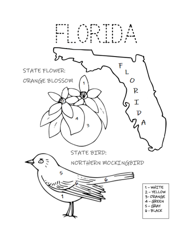
Print and color the state bird and flower of Florida! State Bird: Northern Mockingbird. State Flower: Orange Blossom. One printable coloring page.
Thank you so much for using my printable worksheets in your classroom! Reviews are welcome and very much appreciated. Please browse this store for a selection of printable coloring pages and worksheets! :)
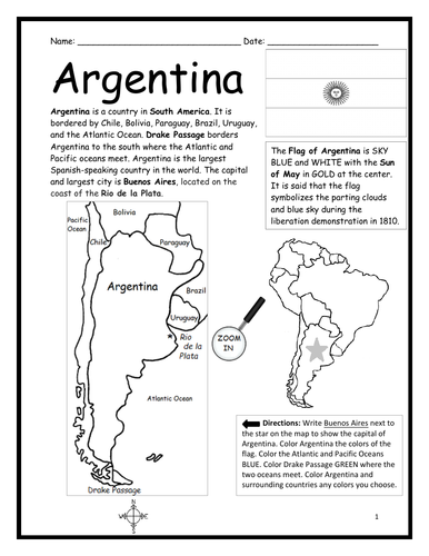
Introduce your students to Argentina in South America with this black & white printable handout of two worksheets (plus answer key). Your students will read a brief introduction to Argentina (location, capital, flag, language), write ‘Buenos Aires’ next to the star on the map to show the location of the capital, color the map and flag, and use the map and compass to answer 7 questions on page 2. Colored pencils and a pen or pencil are needed for this activity. No other prep needed. Basic Geography worksheet with a simple map to introduce the country of Argentina and practice cardinal and ordinal directions.
Please note this worksheet prints in black and white… (1) For easy printing, and (2) so students can do all of the the coloring! For more worksheets in black in white (or color) to introduce your learners to countries of South America and around the world, please browse this store!
Thank you so much for using this worksheet in your classroom! Reviews are welcome and very much appreciated.
Write the name of each state next to the corresponding number below the map of the USA. One worksheet (plus answer key). Use to practice the locations of the 50 states or as a quiz!
For worksheets to introduce your students to each of the 50 states of the USA (and beyond!) please browse this store!
Thank you so much for using my Geography worksheets in your classroom! I hope you find them useful. Reviews are welcome and very much appreciated.
Introduce your students to the 18 regions and capital cities of France with three worksheets (plus answer key). Using the list of regions and capitals of France on page 2, your students will write the capital city of each region on the map of France (page 1). Then answer 8 true/false questions on page 3.
Regions - Capitals included:
Auvergne-Rhône-Alpes - Lyon
Bourgogne-Franche-Comté - Dijon
Bretagne - Rennes
Centre-Val de Loire - Orléans
Corse - Ajaccio
Grand Est - Strasbourg
Hauts-de-France - Lille
Ile-de-France - Paris
Normandie - Rouen
Nouvelle-Aquitaine - Bordeaux
Occitanie - Toulouse
Pays de la Loire - Nantes
Provence–Alpes–Côte d’Azur - Marseille
Guadeloupe - Basse-Terre
Guyane - Cayenne
La Réunion - Saint-Denis
Martinique - Fort-de-France
Mayotte - Mamoudzou
Thank you so much for using my worksheets in your classroom! I hope you find them useful. Reviews are welcome and very much appreciated. Please browse this store for worksheets to introduce your learners to other countries of the world!
Introduce your students to Iran with this printable handout of two worksheets (plus answer key). Your students will read a brief introduction to Iran (location, capital, flag, language), write ‘Tehran’ next to the star on the map to show the location of the capital, color the small map and flag, and use the map and compass to answer 8 questions on page 2. Colored pencils and a pen or pencil are needed for this activity. No other prep needed. Basic Geography worksheet with a simple map to introduce Iran and practice cardinal and ordinal directions.
For use with Interactive Notebooks: After the worksheets are completed, students can cut out the map and flag and paste into the notebook under the topic of Asia (or Middle East) / Sub-Topic: Iran. Under the map, your students can write a summary in their own words of what they now know about this country. Collect handouts for other countries of Asia or the Middle East to add to the notebook! Please browse this store for a selection of printable Geography worksheets for other countries of Asia, the Middle East, and beyond!
Thank you for using my Geography worksheets in your classroom! I hope you find them useful. Reviews are welcome and very much appreciated!