Thank you for visiting! Here you will find a selection of printable, interactive worksheets for your classroom: Basic Geography worksheets with simple maps, ESL, Spanish, Bible, Reading Comprehension and more. I hope you find the resources useful! Reviews are welcome and very much appreciated. Thank you so much.
Thank you for visiting! Here you will find a selection of printable, interactive worksheets for your classroom: Basic Geography worksheets with simple maps, ESL, Spanish, Bible, Reading Comprehension and more. I hope you find the resources useful! Reviews are welcome and very much appreciated. Thank you so much.
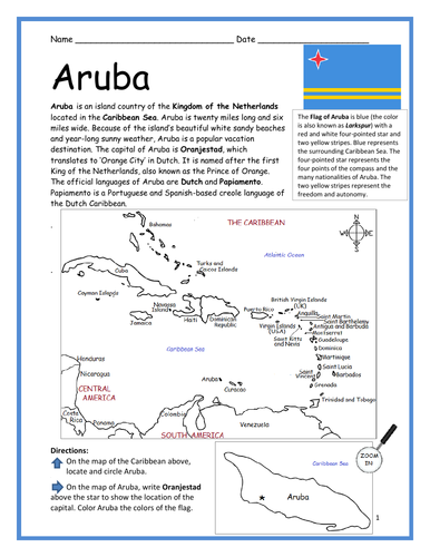
Introduce your learners to ARUBA with two worksheets (plus answer key). Your students will read a brief introduction to Aruba (location, capital, flag, language), locate and circle the island of Aruba on the map of the Caribbean (map 1), write ‘Oranjestad’ next to the star on the map of Aruba (map 2) to show the location of the capital, color the small map, and then use the reading passage, maps and compass to answer 10 true/false questions on page 2. Colored pencils and a pen or pencil are needed for this activity. No other prep needed. Basic Geography worksheet with simple maps to introduce Aruba and practice cardinal and ordinal directions.
For use with Interactive Notebooks: After the worksheets are completed, students can cut out the maps and flag and paste into the notebook under the topic of (example) The Caribbean / Sub-topic: Aruba. Under the map, your students can write a summary in their own words of what they now know about Aruba. Collect worksheets of other countries to add to the notebook! Please browse this store for worksheets to introduce your students to the islands of the Caribbean and beyond!
Thank you so much for using my Geography worksheets in your classroom! I hope you find them useful. Reviews are welcome and very much appreciated!
Using the map of the Caribbean, find the Caribbean islands in the word search puzzle! They can be found forward or backward.
List of Caribbean islands to find: Anguilla, Antigua and Barbuda, Aruba, Bahamas, Barbados, British Virgin Islands, Cayman Islands, Cuba, Dominica, Dominican Republic, Grenada, Guadeloupe, Haiti, Jamaica, Martinique, Montserrat, Navassa Island, Puerto Rico, Saint Barthelemy, Saint Kitts and Nevis, Saint Lucia, Saint Martin, Saint Vincent, Trinidad and Tobago, Turks and Caicos Islands, Virgin Islands.
One printable map/word search puzzle (plus answer key).
Thank you so much for using my worksheets in your classroom! I hope you find them useful. Reviews are welcome and very much appreciated! Please browse this store for more worksheets to introduce your learners to the countries of the world!
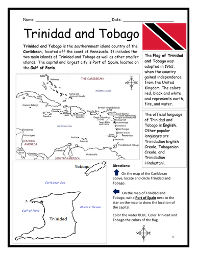
Introduce your learners to Trinidad and Tobago with two printable handouts (plus answer key). Your students will read a brief introduction to Trinidad and Tobago (location, capital, flag, language), write ‘Port of Spain’ next to the star on the map to show the location of the capital, locate and circle Trinidad and Tobago on the map of the Caribbean, color the map, and use the reading passage, maps and compass to answer 9 true/false questions on page 2. Colored pencils and a pen or pencil are needed for this activity. No other prep needed. Basic Geography worksheet with a simple map to introduce Trinidad and Tobago and practice cardinal and ordinal directions. Print and Go!
For use with Interactive Notebooks: After the worksheets are completed, students can cut out the map and flag and paste into the notebook under the topic of (example) The Caribbean / Sub-topic: Trinidad and Tobago. Under the map, your students can write a summary in their own words of what they now know about Trinidad and Tobago. Collect worksheets of other countries of the Caribbean to add to the notebook! All available in this store!
Thank you so much for using my Geography worksheets in your classroom! I hope you find them useful. Reviews are welcome and very much appreciated!
Included: Gulf of Paria, South America, United Kingdom
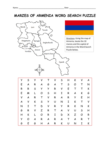
Using the map, find the 10 marzes and the capital of Armenia in the word search puzzle: Aragatsotn, Ararat, Armavir, Gegharkunik, Kotayk, Lori, Shirak, Syunik, Tavush, Vatots Dzor, Yerevan. One printable word search puzzle plus answer key.
Thank you so much for using my Geography worksheets in your classroom! I hope you find them useful. Reviews are welcome and very much appreciated! Please browse this store for more worksheets to introduce your learners to the countries of the world!
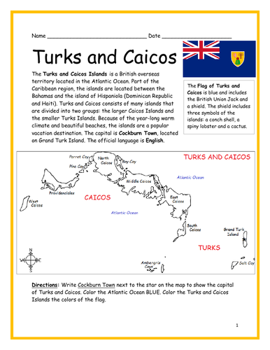
Introduce your learners to Turks and Caicos with two printable worksheets (plus answer key). Simple map activity and reading comprehension questions. Print and Go! No prep needed.
Your students will read a brief introduction to Turks and Caicos (location, capital, flag, language), write ‘Cockburn Town’ next to the star on the map to show the location of the capital, color the map, and use the reading passage, map and compass to answer 10 true/false questions on page 2. Colored pencils and a pen or pencil are needed for this activity. No other prep needed. Basic Geography worksheet with a simple map to introduce Turks and Caicos and practice cardinal and ordinal directions.
For use with Interactive Notebooks: After the worksheets are completed, students can cut out the map and flag and paste into the notebook under the topic of (example) The Caribbean / Sub-topic: Turks and Caicos. Under the map, your students can write a summary in their own words of what they now know about Turks and Caicos. Collect worksheets of other countries to add to the notebook! All available in this store!
Thank you so much for using my Geography worksheets in your classroom. I hope you find them useful. Reviews are welcome and very much appreciated! Please follow me for more worksheets to introduce your learners to the countries of the world.
Included: Providenciales, Grand Turk, North Caicos, Middle Caicos, South Caicos, West Caicos, East Caicos, Parrot Cay, Pine Cay, Bay Cay, Ambergris Cay, Salt Cay, Atlantic Ocean.
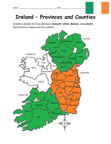
Introduce your learners to the 4 provinces and 32 counties of Ireland! Your students will use the map of Ireland to answer 10 multiple-choice questions on page 2. Answer key included. Basic Geography worksheet with a simple map to introduce the provinces and counties of Ireland. 2 worksheets (plus answer key).
Provinces and Counties included:
Connacht: Galway, Leitrim, Mayo, Roscommon, Sligo
Ulster: Antrim, Armagh, Cavan, Donegal, Down, Fermanagh, Londonderry, Monaghan, Tyrone
Munster: Cork, Kerry, Limerick, Tipperary, Waterford, Clare
Leinster: Carlow, Dublin, Kildare, Kilkenny, Laois, Longford, Louth, Meath, Offaly, Westmeath, Wexford, Wicklow
Thank you so much for using my Geography worksheets! I hope you find them useful. Reviews are welcome and very much appreciated. Please browse this store for a selection of worksheets to introduce your learners to the countries of the world!
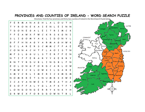
Using the map of Ireland, find the four provinces and thirty-two counties of Ireland in the Word Search Puzzle! They can be found forward or backward.
Provinces and Counties included:
Connacht: Galway, Leitrim, Mayo, Roscommon, Sligo
Ulster: Antrim, Armagh, Cavan, Donegal, Down, Fermanagh, Londonderry, Monaghan, Tyrone
Munster: Cork, Kerry, Limerick, Tipperary, Waterford, Clare
Leinster: Carlow, Dublin, Kildare, Kilkenny, Laois, Longford, Louth, Meath, Offaly, Westmeath, Wexford, Wicklow
One printable word search puzzle (plus answer key).
You may also be interested in:
IRELAND - INTRODUCTORY GEOGRAPHY WORKSHEET
IRELAND - PROVINCES AND COUNTIES INTRODUCTORY WORKSHEET
Thank you so much for using my Geography worksheets to introduce your learners to the countries of the world! I hope you find them useful. Reviews are welcome and very much appreciated.
Introduce your learners to the United States Virgin Islands with two printable handouts (plus answer key). Your students will read a brief introduction to the U.S. Virgin Islands (location, capital, flag, language), write ‘Charlotte Amalie’ next to the star on the map to show the location of the capital, locate and circle the U.S. Virgin Islands on the map of the Caribbean, color the map, and use the reading passage, maps and compass to answer 9 true/false questions on page 2. Colored pencils and a pen or pencil are needed for this activity. No other prep needed. Basic Geography worksheet with a simple map to introduce the U.S. Virgin Islands and practice cardinal and ordinal directions. Print and Go!
For use with Interactive Notebooks: After the worksheets are completed, students can cut out the map and flag and paste into the notebook under the topic of (example) The Caribbean / Sub-topic: United States Virgin Islands. Under the map, your students can write a summary in their own words of what they now know about this country. Collect worksheets of other countries of the Caribbean to add to the notebook! All available in this store!
Thank you so much for using my Geography worksheets in your classroom! I hope you find them useful. Reviews are welcome and very much appreciated! Please follow me for more worksheets to introduce your learners to the countries of the world!
SPED, Resource Room Teacher, Primary school, elementary, reading comprehension
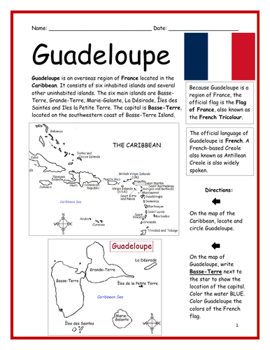
Introduce your learners to Guadeloupe, the overseas region of France located in the Caribbean, with two printable worksheets (plus answer key). Simple map activity and reading comprehension questions. Your students will read a brief introduction to Guadeloupe (location, capital, flag, language), write ‘Basse-Terre’ next to the star on the map to show the location of the capital, color the map, and use the reading passage, maps and compass to answer 9 true/false questions on page 2. Colored pencils and a pen or pencil are needed for this activity. No other prep needed. Basic Geography worksheet with a simple map to introduce Guadeloupe and practice cardinal and ordinal directions. Print and Go!
For use with Interactive Notebooks: After the worksheets are completed, students can cut out the map and flag and paste into the notebook under the topic of (example) The Caribbean / Sub-topic: Guadeloupe. Under the map, your students can write a summary in their own words of what they now know about Guadeloupe. Collect worksheets of other Caribbean islands to add to the notebook!
You may also be interested in worksheets to introduce France and Regions of France, all available in this store!
Thank you so much for using my printables in your classroom. I hope you find them useful. Reviews are welcome and very much appreciated!
SPED, Resource Room Teacher, Primary school, elementary.
Introduce your learners to Saint Barthélemy (also known as St. Barts) with two printable handouts (plus answer key). Your students will read a brief introduction to Saint Barthélemy (location, capital, flag, language), write ‘Gustavia’ next to the star on the map to show the location of the capital, locate and circle Saint Barthélemy on the map of the Caribbean, color the maps, and use the reading passage, maps and compass to answer 9 true/false questions on page 2. Colored pencils and a pen or pencil are needed for this activity. No other prep needed. Basic Geography worksheet with a simple map to introduce Saint Barthélemy and practice cardinal and ordinal directions. Print and Go!
For use with Interactive Notebooks: After the worksheets are completed, students can cut out the map and flag and paste into the notebook under the topic of (example) The Caribbean / Sub-topic: Saint Barthélemy. Under the map, your students can write a summary in their own words of what they now know about Saint Barthélemy. Collect worksheets of other countries to add to the notebook! All available in this store!
Thank you so much for using my Geography worksheets with your students! I hope you find them useful. Reviews are welcome and very much appreciated! Please browse this store for a selection of worksheets to introduce your learners to the countries of the world!
Included: France, Caribbean Sea. Simple map includes islands of Lle Fregate, Lle Chevreau, La Tortue (aka Turtle Island), Lle Coco, Les Saintes.
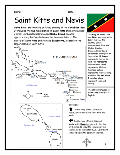
Introduce your learners to Saint Kitts and Nevis with two printable handouts (plus answer key). Your students will read a brief introduction to Saint Kitts and Nevis (location, capital, flag, language), write ‘Basseterre’ next to the star on the map to show the location of the capital, locate and circle Saint Kitts and Nevis on the map of the Caribbean, color the map, and use the reading passage, maps and compass to answer 9 true/false questions on page 2. Colored pencils and a pen or pencil are needed for this activity. No other prep needed. Basic Geography worksheet with a simple map to introduce Saint Kitts and Nevis and practice cardinal and ordinal directions. Print and Go!
For use with Interactive Notebooks: After the worksheets are completed, students can cut out the map and flag and paste into the notebook under the topic of (example) The Caribbean / Sub-topic: Saint Kitts and Nevis. Under the map, your students can write a summary in their own words of what they now know about this country. Collect worksheets of other countries of the Caribbean to add to the notebook! All available in this store!
Thank you so much for using my Geography worksheets in your classroom. I hope you find them useful. Reviews are welcome and very much appreciated!
Introduce your learners to the 10 countries of the African Great Lakes Region one country at a time with a printable worksheet for each country! Simple map activity and reading comprehension questions for each country. For each country, your learners will read a brief introduction (location, capital, flag, language), write the capital next to the star on the map, color the map, and use the map and compass to answer questions on page 2. Two printable worksheets plus answer key for each country. Colored pencils and a pen or pencil are needed for this activity. No other prep needed. Basic Geography worksheets with simple maps to introduce each country and practice cardinal and ordinal directions. Countries included in this bundle: Burundi, DR Congo, Ethiopia, Kenya, Malawi, Mozambique, Rwanda, Tanzania, Uganda, Zambia.
For use with Interactive Notebooks: After the worksheets for a country are completed, students can cut out the map and flag and paste into the notebook under the topic of African Great Lakes Region / Sub-Topic: (country). Under the map and flag, students can write a summary in their own words about what they now know about this country. Add each country until the countries of the African Great Lakes Region are completed!
Also included in this bundle:
-African Great Lakes Introductory Worksheet
-African Great Lakes - Map and Word Search Puzzle
Thank you so much for using my Geography worksheets in your classroom! I hope you find them useful. Reviews are welcome and very much appreciated! Please browse this store for more printables to introduce your learners to the countries of the world!
Using the map of Greece, find the 13 regions in the Word Search Puzzle! They can be found forward or backward. Regions to locate: Attica, Central Macedonia, Thessaly, Western Greece, Crete, Eastern Maccedonia and Thrace, Peloponnese, Central Greece, Epirus, South Aegean, Western Macedonia, Ionian Islands, North Aegean.
1 printable worksheet (plus answer key).
Please browse this store for other Geography worksheets and Word Search Puzzles to introduce your students to the countries of the world!
Thank you so much for using my worksheets in your classroom! I hope you find them useful. Reviews are welcome and very much appreciated!
Introduce your learners to the countries and states of the world with this word search puzzle bundle! Your students will use the map to find the names of countries, states, regions, lakes and more in the Word Search Puzzle! Print and Go!
Word Search Puzzles included in this bundle:
Albania
Greece
Italy
African Great Lakes
Central America
Equator
Germany
Ireland
Malaysia
Armenia
Middle East
Oceania
France
Spain
South America
Caribbean Islands
The Continents
Sahara Desert
The Stans
United States
Thank you so much for using my worksheets with your learners! I hope you find them useful. Reviews are welcome and very much appreciated! Please browse this store for more worksheets to introduce your learners to the countries of the world!
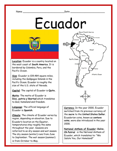
Introduce your learners to Ecuador with this printable handout of two worksheets (plus answer key). This printable worksheet includes a basic fact sheet about Ecuador that includes info such as location, climate, currency, language, and national motto, followed by a Cloze Activity / Fill-in-the-blank worksheet.
Thank you for using my worksheets in your classroom! I hope you find them useful. Reviews are welcome and very much appreciated! Please browse this store for more worksheets to introduce your learners to the countries of the world!
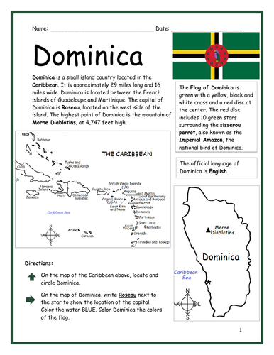
Introduce your learners to the island country of Dominica with two printable worksheets (plus answer key). Simple map activity and reading comprehension questions. Your students will read a brief introduction to Dominica (location, capital, flag, language), locate and circle Dominica on the map of the Caribbean (map 1), write ‘Roseau’ next to the star on the map of Dominica (map 2) to show the location of the capital, color the map, and use the reading passage, maps and compass to answer 10 true/false questions on page 2. Colored pencils and a pen or pencil are needed for this activity. No other prep needed. Basic Geography worksheet with a simple map to introduce Dominica and practice cardinal and ordinal directions. Print and Go!
For use with Interactive Notebooks: After the worksheets are completed, students can cut out the map and flag and paste into the notebook under the topic of (example) The Caribbean / Sub-topic: Dominica. Under the map, your students can write a summary in their own words of what they now know about Dominica. Collect worksheets of other countries of the Caribbean (or North America) to add to the notebook! All available in this store.
Thank you so much for using my Geography worksheets in your classroom! I hope you find them useful. Reviews are welcome and very much appreciated! Please browse this store for more worksheets to introduce your learners to the countries of the world!
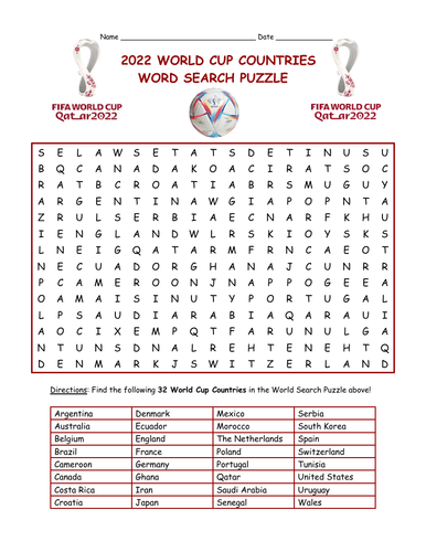
Find the 32 countries of the 2022 World Cup in this word search puzzle! One printable word search puzzle (plus answer key). Countries to find: Argentina, Australia, Belgium, Brazil, Cameroon, Canada, Costa Rica, Croatia, Denmark, Ecuador, England, France, Germany, Ghana, Iran, Japan, Mexico, Morocco, The Netherlands, Poland, Portugal, Qatar, Saudi Arabia, Senegal, Serbia, South Korea, Spain, Switzerland, Tunisia, United States, Uruguay, Wales.
Thank you so much for using my worksheets in your classroom! I hope you find them useful! Reviews are welcome and very much appreciated. Please check out this store for more printables to introduce your learners to the countries of the world!
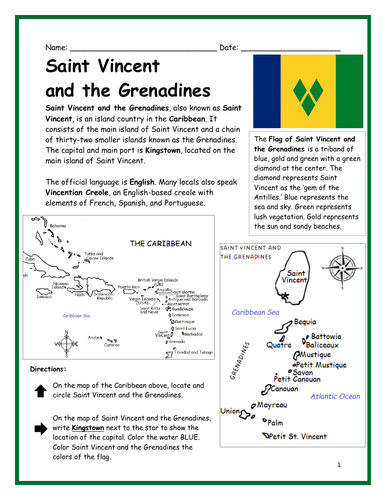
Introduce your learners to Saint Vincent and the Grenadines with two printable worksheets (plus answer key). Simple map activity and reading comprehension questions. Your students will read a brief introduction to Saint Vincent and the Grenadines (location, capital, flag, language), locate and circle Saint Vincent on the map of the Caribbean (map 1), write ‘Kingstown’ next to the star on the map of Saint Vincent (map 2) to show the location of the capital, color the map, and use the reading passage, maps and compass to answer 10 true/false questions on page 2. Colored pencils and a pen or pencil are needed for this activity. No other prep needed. Basic Geography worksheet with a simple map to introduce Saint Vincent and the Grenadines and practice cardinal and ordinal directions. Print and Go!
For use with Interactive Notebooks: After the worksheets are completed, students can cut out the map and flag and paste into the notebook under the topic of (example) The Caribbean / Sub-topic: Saint Vincent and the Grenadines. Under the map, your students can write a summary in their own words of what they now know about this country. Collect worksheets of other countries of the Caribbean (or North America) to add to the notebook! All available in this store!
Thank you so much for using my Geography worksheets in your classroom. I hope you find them useful. Reviews are welcome and very much appreciated!
Introduce your learners to the books of the bible with this bundle of 13 printable handouts! Challenging but fun, this bundle of printable activities will help your students learn to list (and spell!) each book of the Old and New Testament! Print and Go!
Resources included in this bundle:
-Word Search Puzzle for Old Testament
-Word Search Puzzle for New Testament
-Fill in the blanks of the books of the Old Testament
-Fill in the blanks of the books of the New Testament
-Unscramble the books of the Old Testament
-Unscramble the books of the New Testament
Books of the New Testament: Matthew, Mark, Luke, John, Acts, Romans, 1 Corinthians, 2 Corinthians, Galatians, Ephesians, Philippians, Colossians, 1 Thessalonians, 2 Thessalonians, 1 Timothy, 2 Timothy, Titus, Philemon, Hebrews, James, 1 Peter, 2 Peter, 1 John, 2 John, 3 John, Jude, Revelation
Books of the Old Testament: Genesis, Exodus, Leviticus, Numbers, Deuteronomy, Joshua, Judges, Ruth, 1 Samuel, 2 Samuel, 1 Kings, 2 Kings, 1 Chronicles, 2 Chronicles, Ezra, Nehemiah, Esther, Job, Psalms, Proverbs, Ecclesiastes, Song of Solomon, Isaiah, Jeremiah, Lamentations, Ezekiel, Daniel, Hosea, Joel, Amos, Obadiah, Jonah, Micah, Nahum, Habakkuk, Zephaniah, Haggai, Zechariah, Malachi
Thanks so much for using my worksheets in your classroom! I hope you find them useful. Reviews are welcome and very much appreciated. Please Follow Me for more printables!
Thank you again!
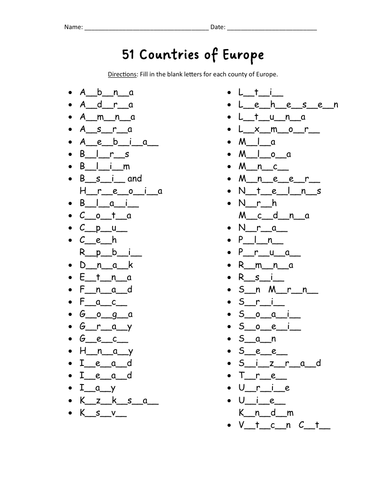
Do your students know all 51 countries of Europe? With this printable activity, your students will fill in the blank letters for each country of Europe! One printable worksheet plus answer key that includes the list of countries in alphabetical order. Print and go!
List of countries included: Albania, Andorra, Armenia, Austria, Azerbaijan, Belarus, Belgium, Bosnia and Herzegovina, Bulgaria, Croatia, Cyprus, Czech Republic, Denmark, Estonia, Finland, France, Georgia, Germany, Greece, Hungary, Iceland, Ireland, Italy, Kazakhstan, Kosovo, Latvia, Lithuania, Luxembourg, Macedonia, Malta, Moldova, Monaco, Montenegro, Netherlands, Norway, Poland, Portugal, Romania, Russia, San Marino, Serbia, Slovakia, Slovenia, Spain, Sweden, Switzerland, Turkey, Ukraine, United Kingdom, Vatican City.
Introduce your learners to each country of Europe one country at a time with a printable worksheet for each country! Each country includes a simple map activity and reading comprehension activities. All available in this store!
Thank you so much for using my worksheets in your classroom! I hope you find them useful. Reviews are welcome and very much appreciated! Please browse this store for more printable worksheets to introduce your learners to the countries of the world!