Thank you for visiting! Here you will find a selection of printable, interactive worksheets for your classroom: Basic Geography worksheets with simple maps, ESL, Spanish, Bible, Reading Comprehension and more. I hope you find the resources useful! Reviews are welcome and very much appreciated. Thank you so much.
Thank you for visiting! Here you will find a selection of printable, interactive worksheets for your classroom: Basic Geography worksheets with simple maps, ESL, Spanish, Bible, Reading Comprehension and more. I hope you find the resources useful! Reviews are welcome and very much appreciated. Thank you so much.
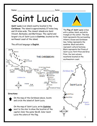
Introduce your learners to Saint Lucia with two printable worksheets (plus answer key). Simple map activity and reading comprehension questions. Your students will read a brief introduction to Saint Lucia (location, capital, flag, language), locate and circle Saint Lucia on the map of the Caribbean (map 1), write ‘Castries’ next to the star on the map of Saint Lucia (map 2) to show the location of the capital, color the map, and use the reading passage, maps and compass to answer 9 true/false questions on page 2. Colored pencils and a pen or pencil are needed for this activity. No other prep needed. Basic Geography worksheet with a simple map to introduce Saint Lucia and practice cardinal and ordinal directions. Print and Go!
For use with Interactive Notebooks: After the worksheets are completed, students can cut out the map and flag and paste into the notebook under the topic of (example) The Caribbean / Sub-topic: Saint Lucia. Under the map, your students can write a summary in their own words of what they now know about this country. Collect worksheets of other countries of the Caribbean (or North America) to add to the notebook! All available in this store!
Thank you so much for using my Geography worksheets in your classroom! I hope you find them useful. Reviews are welcome and very much appreciated! Please browse this store for more worksheets to introduce your learners to the countries of the world!
Included: Petite Piton and Gros Piton.
SPED, Resource Room Teacher, Primary school, elementary.
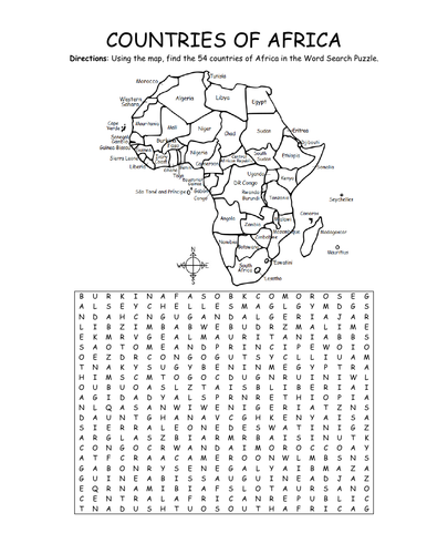
Using the map, find the 54 countries of Africa in this printable Word Search Puzzle! One printable word search puzzle with map (plus answer key).
Countries to find: ALGERIA, ANGOLA, BENIN, BOTSWANA, BURKINA FASO, BURUNDI, CAMEROON, CAPE VERDE, CENTRAL AFRICAN REPUBLIC, CHAD, COMOROS, DJIBOUTI, ESWATINI, GABON, KENYA, EGYPT, EQUATORIAL GUINEA, ERITREA, ETHIOPIA, DR CONGO, CONGO, THE GAMBIA, GHANA, GUINEA, GUINEA-BISSAU, IVORY COAST, LESOTHO, LIBERIA, LIBYA, MADAGASCAR, MALAWI, MALI, MAURITANIA, MAURITIUS, MOROCCO, MOZAMBIQUE, NAMIBIA, NIGER, NIGERIA, RWANDA, SAO TOME AND PRINCIPE, SENEGAL, SEYCHELLES, SIERRA LEONE, SOMALIA, SOUTH AFRICA, SOUTH SUDAN, SUDAN, TANZANIA, TOGO, TUNISIA, UGANDA, WESTERN SAHARA, ZIMBABWE
To introduce your learners to each country of Africa, please browse this store for printable worksheets!
Thank you so much for using my Geography worksheets in your classroom! I hope you find them useful. Reviews are welcome and very much appreciated.
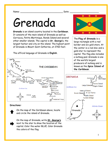
Introduce your learners to the Caribbean island country of Grenada with two printable worksheets (plus answer key). Simple map activity and reading comprehension questions. Your students will read a brief introduction to Grenada (location, capital, flag, language), locate and circle Grenada on the map of the Caribbean (map 1), write ‘St. George’s’ next to the star on the map of Grenada (map 2) to show the location of the capital, color the map, and use the reading passage, maps and compass to answer 10 true/false questions on page 2. Colored pencils and a pen or pencil are needed for this activity. No other prep needed. Basic Geography worksheet with a simple map to introduce Dominica and practice cardinal and ordinal directions. Print and Go!
For use with Interactive Notebooks: After the worksheets are completed, students can cut out the map and flag and paste into the notebook under the topic of (example) The Caribbean / Sub-topic: Grenada. Under the map, your students can write a summary in their own words of what they now know about this country. Collect worksheets of other countries of the Caribbean (or North America) to add to the notebook! All available in this store!
Thank you so much for using my Geography worksheets in your classroom! I hope you find them useful. Reviews are welcome and very much appreciated! Please browse this store for more worksheets to introduce your learners to the countries of the world!
Islands included on map of Grenada: Carriacou, Petite Martinique, Saline Island, Frigate, Large, Diamond, Ronde, Les Tantes, Caille, London Bridge
SPED, Resource Room Teacher, Primary school, elementary.
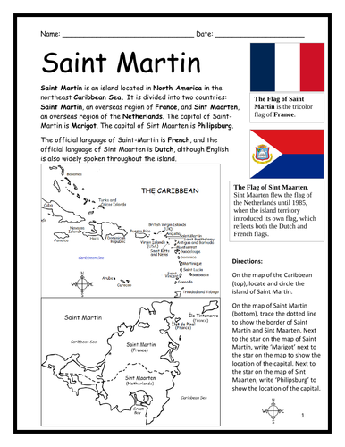
Introduce your learners to the island of Saint Martin with two printable worksheets (plus answer key). Simple map activity and reading comprehension questions. Print and Go!
Your students will read a brief introduction to Saint Martin (location, capital, flag, language), locate and circle the island of Saint Martin on the map of the Caribbean (map 1), trace the dotted line on the map of Saint Martin (map 2) to show the border of Saint Martin (an overseas region of France) and Sint Maarten (an overseas region of the Netherlands), write ‘Marigot’ next to the star on the map of Saint Martin to show the location of the capital, write ‘Philipsburg’ next to the star on the map of Sint Maarten to show the location of the capital, and use the reading passage, maps and compass to answer 9 true/false questions on page 2.
For use with Interactive Notebooks: After the worksheets are completed, students can cut out the map and flags and paste into the notebook under the topic of (example) The Caribbean / Sub-topic: Saint Martin. Under the map, your students can write a summary in their own words of what they now know about this island. Collect worksheets of other countries of the Caribbean to add to the notebook! All available in this store!
Thank you so much for using my Geography worksheets in your classroom! I hope you find them useful. Reviews are welcome and very much appreciated! Please browse this store for more printable worksheets with simple maps to introduce your students to the countries of the world!
Introduce your learners to Suriname with this printable handout of two worksheets (plus answer key). Your students will read a brief introduction to Suriname (location, capital, flag, language), write 'Paramaribo' next to the star on the map to show the location of the capital, trace the Suriname River and color the map, and use the map and compass to answer 6 questions on page 2. Colored pencils and a pen or pencil are needed for this activity. No other prep needed. Basic Geography worksheet with a simple map to introduce Suriname and practice cardinal and ordinal directions.
For use with Interactive Notebooks: After the worksheets are completed, students can cut out the map and flag and paste into the notebook under the topic of South America/Sub-Topic: Suriname. Under the map, your students can write a summary in their own words of what they now know about this country. Collect worksheets for other countries of South America to add to the notebook! Please browse this store for a selection of worksheets for other countries of South America (and beyond!).
Thank you so much for using my Geography worksheets in your classroom! Reviews are welcome and very much appreciated.
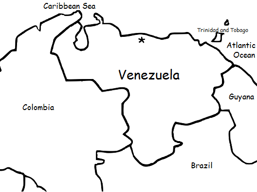
Introduce your students to Venezuela with this printable handout of two worksheets (plus answer key). Your students will read a brief overview of Venezuela (location, capital, language, flag), write 'Caracas' next to the star on the map to show the capital, color the small map of Venezuela and surrounding countries, and use the map and compass to answer (6) questions. Basic Geography worksheet with a simple map to introduce the country of Venezuela and practice cardinal and ordinal directions.
For use with Interactive Notebooks: After the handout is completed, students can cut out the map and flag of Venezuela and paste into the notebook under the topic of South America/Sub-Topic: Venezuela. Under the map, students can write a summary in their own words of what they now know about this country. Collect handouts for other countries of South America (or Spanish-speaking countries) to add to the notebook. Please browse this store for a selection of printable handouts for other countries of South America (and beyond!).
Thank you so much for using my Geography worksheets in your classroom! I hope you find them useful. Reviews are welcome and very much appreciated.
Thank you again!
Key Words: coloring page, color, cardinal, ordinal, Trinidad and Tobago, Spanish, Caribbean Sea, Atlantic Ocean
This packet of printable handouts can be used as a supplement to the printable book https://www.tes.com/teaching-resource/my-spanish-picture-dictionary-11829384 or on its own.
This packet includes WINTER vocabulary words in SPANISH: winter, coat, hat, gloves, mittens, snowman, boots, scarf, sled, skate. Español: el invierno, el patín, las botas, el abrigo, el trineo, el muñeco de nieve, la bufanda, los mitones, los guantes, el gorro
Page 1: Read and write the Winter word in Spanish. 1-5
Page 2: Read and write the Winter word in Spanish. 6-9
Page 3: Match the Winter word in Spanish with the correct picture.
Page 4: Word Search - Find the Winter words in Spanish.
Page 5: QUIZ: Write the correct Winter word in Spanish next to each picture.
Page 6: Quiz Answer Key.
Page 7: Word Search Answer Key.
Thank you so much for using my printable worksheets in your classroom!
Introduce your students to Bolivia with this printable handout of two worksheets (plus answer key). Your students will read a brief overview of Bolivia (location, capital, flag, language), write 'Sucre' next to the star on the map to show the capital, color the small map and flag, and use the map and compass to answer 7 questions. Colored pencils and a pen or pencil are needed for this activity. No other prep needed. Basic Geography worksheet with a simple map to introduce Bolivia and practice cardinal and ordinal directions.
For use with Interactive Notebooks: After the handout is completed, students can cut out the map and flag and paste into the notebook under the topic of South America/Sub-topic: Bolivia. Under the map, students will write a summary in their own words of what they now know about this country. Collect handouts for other countries of South America to add to the notebook! Please browse this store for a selection of printable handouts for other countries of South America (and beyond!).
Thank you so much for using my Geography worksheets in your classroom!
Introduce your students to Belarus with two worksheets (plus answer key). Your students will read a brief introduction to Belarus (location, capital, flag, language), write 'Minsk' next to the star on the map to show the location of the capital, color the small map and flag, and use the map and compass to answer 6 questions on page 2. Colored pencils and a pen or pencil are needed for this activity. No other prep needed. Basic Geography worksheet with a simple map to introduce Belarus and practice cardinal/ordinal directions.
For use with Interactive Notebooks: After the worksheets are completed, students can cut out the map and flag and paste into the notebook under the topic of Europe/Sub-topic: Belarus. Under the map, students can write a summary in their own words of what they now know about this country. Collect worksheets for other countries of Europe to add to the notebook! All available in this store. Please browse this store for a selection of worksheets for other countries of Europe (and beyond!).
Thank you so much for using my Geography worksheets in your classroom! I hope you find them useful. Reviews are welcome and very much appreciated.
Introduce your students to Argentina with this printable handout of two worksheets (plus answer key). Your students will read a brief overview of Argentina (location, capital, flag, language), write 'Buenos Aires' next to the star on the map to show the capital, color the small map and flag, and use the map and compass to answer 7 questions. Colored pencils and a pen or pencil are needed for this activity. No other prep needed. Basic Geography worksheet with a simple map to introduce Argentina and practice cardinal and ordinal directions.
For use with Interactive Notebooks: After the worksheets are completed, students can cut out the map and paste into the notebook under the topic of South America/Sub-topic: Argentina. Under the map, students can write a summary in their own words of what they now know about this country. Collect worksheets for other countries of South America to add to the notebook! Please browse this store for a selection of printable worksheets for other countries of South America (and beyond)!
Thank you so much for using my Geography worksheets in your classroom!
Introduce your students to COLOMBIA in South America with two printable worksheets (plus answer key). Your students will read a brief introduction to Colombia (location, capital, language, flag), write Bogotá next to the star on the map to show the location of the capital, color the map, and use the map and compass to answer (7) questions on page 2. Colored pencils and a pen or pencil are needed for this activity. No other prep needed. Basic Geography worksheet with a simple map to introduce Colombia and practice cardinal and ordinal directions.
For use with Interactive Notebooks: After the worksheets are completed, students can cut out the map and flag and paste into the notebook under the topic of South America/Sub-topic: Colombia. Under the map, they can write a summary in their own words of what they now know about this country. Collect handouts for other countries of South America to add to the notebook! All available in this store. Please browse this store for a selection of printable handouts for other countries of South America (and beyond!).
Thank you so much for using my Geography worksheets in your classroom! I hope you find them useful. Reviews are welcome and very much appreciated!
Introduce your learners to AUSTRIA with two worksheets (plus answer key). Your students will read a brief introduction to Austria (location, capital, flag, language), write ‘Vienna’ next to the star on the map to show the location of the capital, color the small map and flag, and use the map and compass to answer 7 questions on page 2. Colored pencils and a pen or pencil are needed for this activity. No other prep needed. Basic Geography worksheet with a simple map to introduce Austria and practice cardinal and ordinal directions.
For use with Interactive Notebooks: After the worksheets are completed, students can cut out the map and flag and paste into the notebook under the topic of Europe / Sub-topic: Austria. Under the map, students can write a summary in their own words of what they now know about Austria. Collect worksheets for other countries of Europe to add to the notebook! All available in this store! Please browse this store for a selection of printable Geography worksheets for other countries of Europe (and beyond!).
Thank you for using my Geography worksheets in your classroom! I hope you find them useful. Reviews are welcome and very much appreciated!
German
Introduce your learners to Finland with two worksheets (plus answer key). Your students will read a brief introduction to Finland (location, capital, flag, language), write 'Helsinki' next to the star on the map to show the location of the capital, color the map, and use the map and compass to answer 6 questions on page 2. Colored pencils and a pen or pencil are needed for this activity. No other prep needed. Basic Geography worksheet with a simple map to introduce Finland and practice cardinal and ordinal directions.
For use with Interactive Notebooks: After completing the worksheets, students can cut out the map and flag and paste it into the notebook under the topic of Europe / Sub-Topic: Finland. Under the map and flag, students can write a summary in their own words of what they now know about Finland. Collect worksheets for other countries of Europe to add to the notebook! Please browse this store for worksheets for other countries of Europe (and beyond!)
Thank you so much for using my worksheets in your classroom!
Introduce your students to Hungary with two worksheets (plus answer key). Your students will read a brief introduction to Hungary (location, capital, flag, language), write 'Budapest' next to the star on the map to show the location of the capital, color the small map and flag, and use the map and compass to answer 9 questions on page 2. Colored pencils and a pen or pencil are needed for this activity. No other prep needed. Basic Geography worksheet with a simple map to introduce Hungary and practice cardinal and ordinal directions.
For use with Interactive Notebooks: After completing the worksheets, students can cut out the map and flag and paste it into the notebook under the topic of Europe / Sub-Topic: Hungary. Under the map and flag, students can write a summary in their own words of what they now know about this country. Collect worksheets for other countries of Europe to add to the notebook! Please browse this store for a selection of worksheets for other countries of Europe (and beyond!).
Thank you so much for using my Geography worksheets in your classroom! Reviews are welcome and very much appreciated.
Introduce your students to Czech Republic with this printable handout of two worksheets (plus answer key). Your students will read a brief overview of Czech Republic (location, capital, flag, language), write 'Prague' next to the star on the map to show the capital, color the small flag and map, and use the map and compass to answer 7 questions. Colored pencils and a pen or pencil are needed for this activity. No other prep needed.
For use with Interactive Notebooks: After completing the handout, students can cut out the map and flag and paste it into the notebook under the topic of Europe / Sub-Topic: Czech Republic. Under the map and flag, students can write a summary in their own words of what they now know about Czech Republic. Collect handouts for all countries of Europe to add to notebook.
Thank you so much for using my Geography worksheets in your classroom! Reviews are welcome and very much appreciated. Please follow my store for more Geography worksheets.
Thank you again!
cardinal, ordinal, directions, Czechoslovakia, north, south, east, west.
Introduce your students to the country of Paraguay in South America with this printable handout of two worksheets (plus answer key). Your students will read a brief introduction to Paraguay (location, capital, flag, language), write 'Asunción' next to the star on the map to show the location of the capital, color the map and flag, and use the map and compass to answer 6 questions on page 2. Colored pencils and a pen or pencil are needed for this activity. No other prep needed. Basic Geography worksheet with a simple map to introduce the country of Paraguay and practice cardinal and ordinal directions.
For use with Interactive Notebooks: After the worksheets for Paraguay are completed, students can cut out the map and flag and paste into the notebook under the topic of South America/Sub-Topic: Paraguay. Under the map, students can write a summary in their own words of what they now know about this country. Please browse this store for a selection of worksheets for other countries of South America (and beyond!)
Thank you so much for using my Geography worksheets in your classroom! Reviews are welcome and very much appreciated!
Introduce your students to the countries and capitals of South America! This printable handout of 4 pages includes a list of the 12 countries and capitals and the 3 dependent territories and capitals of South America. Your students will read a brief introduction to South America, write the capital of each country on the map, color the map, and answer the questions that follow. Answer key included.
For worksheets for each country of South America, please check out this discounted bundle: https://www.tes.com/teaching-resource/resource-12525113
Thank you so much for using my Geography worksheets in your classroom! I hope you find them useful. Reviews are welcome and very much appreciated!
Introduce your students to Uruguay with this printable handout of two worksheets (plus answer key). Your students will read a brief overview of Uruguay (location, capital, language, flag), write 'Montevideo' next to the star on the map to show the capital, color the small map and flag, and use the map and compass to answer 7 questions. Basic Geography worksheet with a simple map to introduce Uruguay and practice cardinal and ordinal directions.
For use with Interactive Notebooks: After the handout is completed, students can cut out the map and flag and paste into the notebook under the topic of South America/Sub-Topic: Uruguay. Under the map, your students will write a summary in their own words of what they now know about this country. Collect handouts for other countries of South America to add to the notebook! Please browse this store for a selection of printable Geography worksheets for other countries of South America (and beyond!).
Thank you so much for using my Geography worksheets in your classroom! I hope you find them useful. Reviews are welcome and very much appreciated. Please follow this store for more printables.
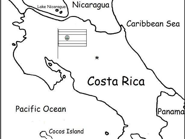
Introduce your students to Costa Rica with two worksheets (plus answer key). Your students will read a brief introduction to Costa Rica (location, capital, language, flag), write 'San José' next to the star on the map to show the location of the capital, color the small flag and map, and use the map and compass to answer 6 questions on page 2. Colored pencils and a pen or pencil are needed for this activity. No other prep needed. Basic Geography worksheet with a simple map to introduce Costa Rica and practice cardinal and ordinal directions.
For use with Interactive Notebooks: After the worksheets are completed, students can cut out the map and flag and paste into the notebook under the topic of Central America (or Spanish-Speaking Countries) /Sub-Topic: Costa Rica. Under the map and flag, students can write a summary in their own words of what they now know about this country. Collect worksheets for other countries of Central America (or Spanish-Speaking Countries) to add to the notebook! Worksheets for all countries available in this store! Please browse this store for a selection of printable Geography worksheets for other countries of Central America and beyond!
Thank you so much for using my Geography worksheets in your classroom! I hope you find them useful. Reviews are welcome and very much appreciated! Please browse this store for a selection of worksheets to introduce your learners to the countries of the world!
Teach your students about Africa with this packet of 7 printable worksheets.
Page 1 is a list of the 54 countries of Africa in alphabetical order.
Page 2 is a map of Africa. Your students will write the name of each country on the map.
Page 3: Word Search: Find African countries A-L.
Page 4: Word Search: Find African countries M-Z.
Pages 5-6: List the 54 countries of Africa A-Z (your students will see how many they can remember on their own before referring to the list and map).
Page 7: Languages of Africa. Fill in the blank.
Thank you for using my Geography worksheets in your classroom!