Thank you for visiting! Here you will find a selection of printable, interactive worksheets for your classroom: Basic Geography worksheets with simple maps, ESL, Spanish, Bible, Reading Comprehension and more. I hope you find the resources useful! Reviews are welcome and very much appreciated. Thank you so much.
Thank you for visiting! Here you will find a selection of printable, interactive worksheets for your classroom: Basic Geography worksheets with simple maps, ESL, Spanish, Bible, Reading Comprehension and more. I hope you find the resources useful! Reviews are welcome and very much appreciated. Thank you so much.
Teach your students the states of Northeast USA with this printable handout of two worksheets (plus answer key).
This list includes 11 states: The states of New England: Maine (ME), New Hampshire (NH), Vermont (VT), Massachusetts (MA), Rhode Island (RI), and Connecticut (CT), and the Middle States: New York (NY), Pennsylvania (PA), New Jersey (NJ) and Delaware (DE). Your students will write the full name of each state on the map, then color the six states of New England one color and the middle states another color. Then they will use the map and compass to answer six questions.
Colored pencils or crayons and a pen or pencil are needed for this activity.
Thank you so much for using my resources in your classroom!
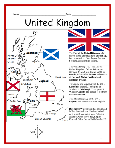
Introduce your learners to the United Kingdom with three interactive worksheets (plus answer key). Page 1: Your learners will read a brief introduction to the United Kingdom (location, capital, flag, language), write the capital of England, Scotland, Wales and Northern Ireland next to each star on the map, and color the water surrounding the UK BLUE. Page 2: Use the map and compass to answer 6 multiple choice questions. Page 3: Match the flag to the country: England, Scotland, Wales and Northern Ireland. Page 4: Answer Key. Basic Geography worksheet with a simple map to introduce the United Kingdom.
For use with Interactive Notebooks: After completing the worksheets, students can cut out the map and flag and paste into the notebook under the topic of Europe / Sub-Topic: United Kingdom. Under the map and flag, students can write a summary in their own words of what they now know about the UK. Collect worksheets for other countries of Europe to add to the notebook! Please browse this store for worksheets for other countries of Europe (and beyond!).
Thank you for using my Geography worksheets in your classroom! I hope you find them useful! Reviews are welcome and very much appreciated.
Introduce your students to Puerto Rico with this printable handout of two worksheets (plus answer key). Your students will read a brief introduction to Puerto Rico (location, capital, flag, language), write ‘San Juan’ next to the star on the map to show the location of the capital, color the small map and flag, and use the map and compass to answer 6 questions on page 2. Colored pencils and a pen or pencil are needed for this activity. No other prep needed.
For use with Interactive Notebooks: After the worksheets are completed, students can cut out the map and flag of Puerto Rico and paste into the notebook. Under the map and flag, students can write a summary in their own words of what they now know about Puerto Rico. Collect worksheets for other countries to add to the notebook! Please browse this store for a selection of worksheets for Caribbean Islands, Spanish-speaking countries, and beyond!
Thank you so much for using my Geography worksheets in your classroom! I hope you find them useful. Reviews are welcome and very much appreciated!
Included on map of Puerto Rico and surrounding: Atlantic Ocean, Caribbean Sea, Mona, Culebra, Viequez, Desecheo, Florida, Dominican Republic, Haiti, Cuba. Cardinal, ordinal directions.
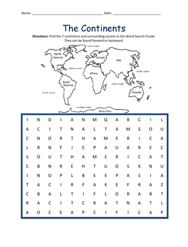
Find the 7 continents and surrounding oceans in the Word Search Puzzle. They can be found forward or backward: Africa, Antarctica, Asia, Europe, North America, Oceania, South America, Arctic, Atlantic, Indian, Pacific, Southern.
Thank you for using my worksheets in your classroom! Please browse this store for a selection of printable worksheets: Geography, Spanish, Reading Comprehension, Bible, and more.
Introduce your students to the country of SOUTH AFRICA with two worksheets (plus answer key). Your students will read a brief introduction to South Africa (location, capitals, flag, language), write ‘Pretoria’ next to the ‘A’ on the map to show the administrative capital; write ‘Bloemfontein’ next to the ‘J’ to show the judicial capital; write ‘Cape Town’ next to the ‘L’ on the map to show the legislative capital, color the small map, and use the map and compass to answer 9 questions on page 2. Basic Geography Worksheet with a simple map to introduce South Africa and practice cardinal and ordinal directions. Colored pencils and a pen or pencil are needed for this activity.
For use with Interactive Notebooks: After the worksheets are completed, students can cut out the map and flag and paste into the notebook under the topic of Africa / Sub-Topic: South Africa. Under the map, students can write a summary in their own words of what they now know about this country. Collect worksheets for other countries of Africa to add to the notebook! Please browse this store for a selection of worksheets for other countries of Africa (and beyond!).
Thank you so much for using my Geography worksheets in your classroom! I hope you find them useful. Reviews are welcome and very much appreciated.
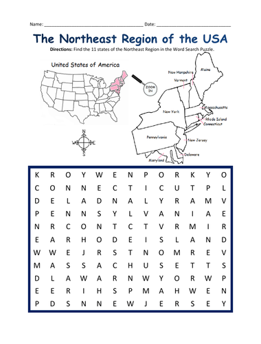
Introduce your students to the NORTHEAST REGION of the United States with this printable handout of one page (plus answer key). Using the map of the Northeast Region, find the eleven states in the word search puzzle: Connecticut, Maine, Massachusetts, New Hampshire, Rhode Island, Vermont, Delaware, Maryland, New Jersey, New York, Pennsylvania.
Other regions also available! Please browse this store for printable handouts for other regions of the United States and other Geography worksheets!
-SOUTHWEST REGION MAP AND WORD SEARCH
-MIDWEST REGION MAP AND WORD SEARCH
-SOUTHEAST REGION MAP AND WORD SEARCH
-WEST REGION MAP AND WORD SEARCH
Thank you so much for using my Geography worksheets in your classroom!
Trace the words of the Bible Verse: Job 12:7-10 (NIV): “But ask the animals, and they will teach you, or the birds in the sky, and they will tell you; or speak to the earth, and it will teach you, or let the fish in the sea inform you. Which of all these does not know that the hand of the Lord has done this? In his hand is the life of every creature and the breath of all mankind.” 1 printable handout includes 8 of God’s creatures to color (bird, deer, giraffe, bear, fish, whale, dolphin, tiger).
Shorter version is also available - (PSALM 12:10).
Other Bible Verse Printables Available:
Fruit of the Spirit (trace the bible verse and color the fruit).
Fruit of the Spirit (fill in the blanks and color the fruit).
Thanksgiving Bible Verse Psalm 69:30 (trace the bible verse and color the turkey)
For worksheets to learn the Books of the Old Testament and New Testament, please check out the Books of the Bible Bundle.
Thank you so much for using my printable handouts! Reviews are welcome and very much appreciated.
Note: Illustrations used with permission from Pro Lingua Associates, publisher of Coloring in English - A Vocabulary Builder for Beginners. Coloring in English includes 400 everyday, basic vocabulary and sight words with pictures to color and learn.
Fill in the blank of each sentence with the correct contraction. Printable handout of 2 worksheets with 10 sentences on each page.
Contractions included:
Page 1:
I would = I’d
She would = She’d
He would = He’d
They would = They’d
You would = You’d
I am = I’m
She is = She’s
He is = He’s
They are = They’re
You are = You’re
Page 2:
I will = I’ll
She will = She’ll
He will = He’ll
They will = They’ll
You will = You’ll
do not = don’t
does not = doesn’t
will not = won’t
did not = didn’t
should not = shouldn’t
Thank you for using my printable worksheets in your classroom! I hope you find them useful. Reviews are welcome and very much appreciated!
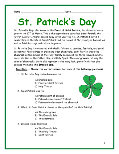
Why is St. Patrick’s Day celebrated on March 17? Why do people wear green? What are shamrocks and why do we see them everywhere on St. Patrick’s Day? Find the answers in this printable handout! Your students will read a short passage about St. Patrick’s Day and answer the questions that follow. Includes multiple-choice questions, cloze activity/fill in the blank. Two printable worksheets (plus answer key).
Thank you for using my worksheets in your classroom! I hope you find them useful. Reviews are welcome and very much appreciated!
Reading comprehension, vocabulary building, ESL.
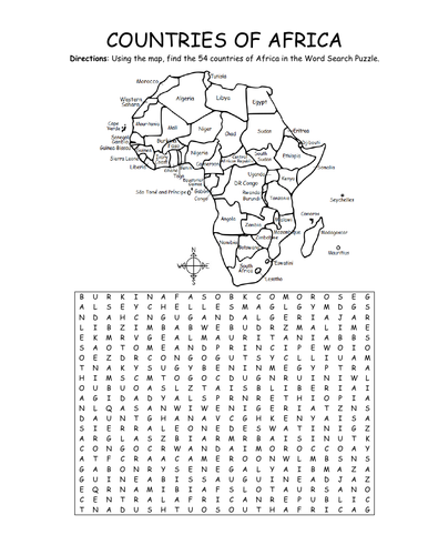
Using the map, find the 54 countries of Africa in this printable Word Search Puzzle! One printable word search puzzle with map (plus answer key).
Countries to find: ALGERIA, ANGOLA, BENIN, BOTSWANA, BURKINA FASO, BURUNDI, CAMEROON, CAPE VERDE, CENTRAL AFRICAN REPUBLIC, CHAD, COMOROS, DJIBOUTI, ESWATINI, GABON, KENYA, EGYPT, EQUATORIAL GUINEA, ERITREA, ETHIOPIA, DR CONGO, CONGO, THE GAMBIA, GHANA, GUINEA, GUINEA-BISSAU, IVORY COAST, LESOTHO, LIBERIA, LIBYA, MADAGASCAR, MALAWI, MALI, MAURITANIA, MAURITIUS, MOROCCO, MOZAMBIQUE, NAMIBIA, NIGER, NIGERIA, RWANDA, SAO TOME AND PRINCIPE, SENEGAL, SEYCHELLES, SIERRA LEONE, SOMALIA, SOUTH AFRICA, SOUTH SUDAN, SUDAN, TANZANIA, TOGO, TUNISIA, UGANDA, WESTERN SAHARA, ZIMBABWE
To introduce your learners to each country of Africa, please browse this store for printable worksheets!
Thank you so much for using my Geography worksheets in your classroom! I hope you find them useful. Reviews are welcome and very much appreciated.
Introduce your students to Japan with this printable handout of two worksheets (plus answer key). Your students will read a brief introductin to Japan (location, capital, flag, language), write ‘Tokyo’ next to the star on the map to show the location of the capital, color the small map and flag, and use the map and compass to answer 7 questions on page 2. Colored pencils and a pen or pencil are needed for this activity. No other prep needed. Basic Geography worksheet with a simple map to introduce Japan and practice cardinal and ordinal directions.
For use with Interactive Notebooks: After the worksheets are completed, students can cut out the map and flag and paste into the notebook under the topic of Asia / Sub-Topic: Japan. Under the map and flag, your students can write a summary in their own words of what they now know about this country. Collect handouts for other countries of Asia to add to the notebook! Please browse this store for a selection of worksheets for all other countries of Asia (and beyond!)
Thank you so much for using my Geography worksheets in your classroom! I hope you find them useful. Reviews are welcome and very much appreciated!
Japanese Archipelago, Islands of Honshu, Hokkaido, Kyushu, Shikoku.
Nisshōki, Hinomaru, Maritime borders. Dialect. Okinawa, Ryukyu Islands.
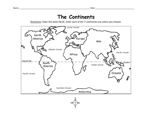
Color the map of the 7 continents with this printable handout (1 coloring page). Colored pencils or crayons are needed for this activity. No other prep needed.
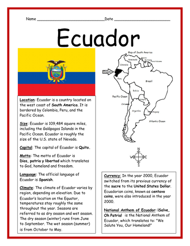
Introduce your learners to Ecuador with this printable handout of two worksheets (plus answer key). This printable worksheet includes a basic fact sheet about Ecuador that includes info such as location, climate, currency, language, and national motto, followed by a Cloze Activity / Fill-in-the-blank worksheet.
Thank you for using my worksheets in your classroom! I hope you find them useful. Reviews are welcome and very much appreciated! Please browse this store for more worksheets to introduce your learners to the countries of the world!
Cut out each flag and paste into the map of Central America: Belize, Guatemala, Honduras, El Salvador, Costa Rica, Nicaragua, Panama. This printable handout includes 7 flags and a map to cut out and paste into your interactive notebook.
Find the 21 Spanish-Speaking Countries in the Word Search Puzzle! One printable Word Search Puzzle (plus answer key).
Countries to find in the Word Search Puzzle: Argentina, Bolivia, Chile, Colombia, Costa Rica, Cuba, Dominican Republic, Ecuador, El Salvador, Equatorial Guinea, Guatemala, Honduras, Mexico, Nicaragua, Panama, Paraguay, Peru, Puerto Rico, Spain Uruguay, Venezuela.
Flags for each country included!
Please browse this store for other worksheets to introduce your learners to the Spanish-Speaking Countries! SPANISH-SPEAKING COUNTRIES FILL IN THE BLANKS, SPANISH-SPEAKING COUNTRIES SCRAMBLE, and more! Worksheets also available to introduce your learners to each Spanish-Speaking country!
Thank you so much for using my worksheets in your classroom! I hope you find them useful and fun. Reviews are welcome and very much appreciated. Please FOLLOW THIS STORE!!
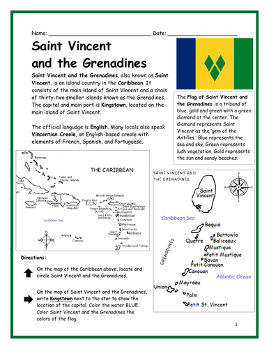
Introduce your learners to Saint Vincent and the Grenadines with two printable worksheets (plus answer key). Simple map activity and reading comprehension questions. Your students will read a brief introduction to Saint Vincent and the Grenadines (location, capital, flag, language), locate and circle Saint Vincent on the map of the Caribbean (map 1), write ‘Kingstown’ next to the star on the map of Saint Vincent (map 2) to show the location of the capital, color the map, and use the reading passage, maps and compass to answer 10 true/false questions on page 2. Colored pencils and a pen or pencil are needed for this activity. No other prep needed. Basic Geography worksheet with a simple map to introduce Saint Vincent and the Grenadines and practice cardinal and ordinal directions. Print and Go!
For use with Interactive Notebooks: After the worksheets are completed, students can cut out the map and flag and paste into the notebook under the topic of (example) The Caribbean / Sub-topic: Saint Vincent and the Grenadines. Under the map, your students can write a summary in their own words of what they now know about this country. Collect worksheets of other countries of the Caribbean (or North America) to add to the notebook! All available in this store!
Thank you so much for using my Geography worksheets in your classroom. I hope you find them useful. Reviews are welcome and very much appreciated!
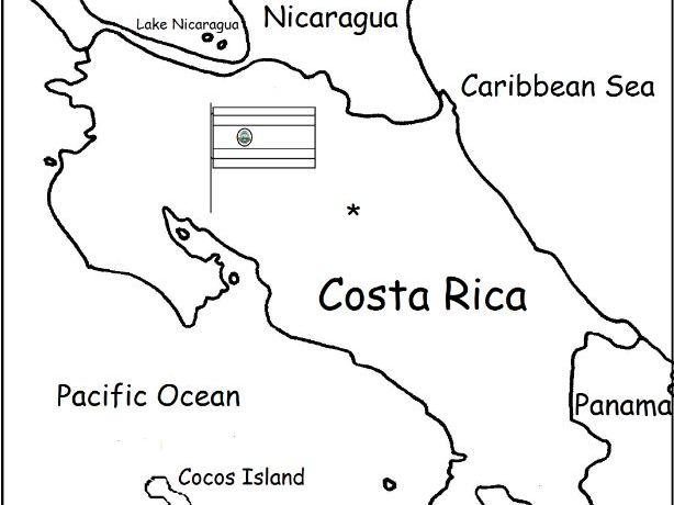
Introduce your students to Costa Rica with two worksheets (plus answer key). Your students will read a brief introduction to Costa Rica (location, capital, language, flag), write 'San José' next to the star on the map to show the location of the capital, color the small flag and map, and use the map and compass to answer 6 questions on page 2. Colored pencils and a pen or pencil are needed for this activity. No other prep needed. Basic Geography worksheet with a simple map to introduce Costa Rica and practice cardinal and ordinal directions.
For use with Interactive Notebooks: After the worksheets are completed, students can cut out the map and flag and paste into the notebook under the topic of Central America (or Spanish-Speaking Countries) /Sub-Topic: Costa Rica. Under the map and flag, students can write a summary in their own words of what they now know about this country. Collect worksheets for other countries of Central America (or Spanish-Speaking Countries) to add to the notebook! Worksheets for all countries available in this store! Please browse this store for a selection of printable Geography worksheets for other countries of Central America and beyond!
Thank you so much for using my Geography worksheets in your classroom! I hope you find them useful. Reviews are welcome and very much appreciated! Please browse this store for a selection of worksheets to introduce your learners to the countries of the world!
Introduce your learners to CHINA with this printable handout of two worksheets (plus answer key). Your students will read a brief introduction to China (location, capital, language, flag), write ‘Beijing’ next to the star on the map to show the location of the capital, color the flag and map, and use the map and compass to answer 10 questions on page 2. Colored pencils and a pen or pencil are needed for this activity. No other prep needed. Basic Geography worksheet with a simple map to introduce China and practice cardinal/ordinal directions.
For use with Interactive Notebooks: After your students complete the worksheets, they can cut out the map and paste into the notebook under the topic Asia/Sub-topic: China. Under the map, your students can write a summary in their own words of what they now know about China. Collect worksheets for other countries of Asia to add to the notebook! Please browse this store for a selection of printable Geography worksheets for other countries of Asia (and beyond!).
Thank you so much for using my Geography worksheets in your classroom! I hope you find them useful! Reviews are welcome and very much appreciated.
Notes: China shares land borders with 14 countries: Vietnam, Laos, Myanmar,
India, Bhutan, Nepal, Afghanistan, Pakistan, Tajikistan,
Kyrgyzstan, Kazakhstan, Russia, Mongolia, and North Korea. Pacific Ocean.