A colouring sheet to help students learn and remember facts about continental and oceanic crusts as part of their tectonics module in geography.
Follow my educational videos on YouTube: https://www.youtube.com/c/sarahrowssolo
Sign up for a free Skype in the Classroom session as I prepare for my Great British Viking Quest solo row around Great Britain in summer 2017: https://education.microsoft.com/vikingquest
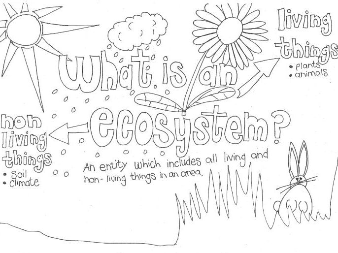
A colouring sheet to help students learn and answer the question 'what is an ecosystem'.
Follow my educational videos on YouTube: https://www.youtube.com/c/sarahrowssolo
Sign up for a free Skype in the Classroom session as I prepare for my Great British Viking Quest solo row around Great Britain in summer 2017: https://education.microsoft.com/vikingquest
Geography revision notes for coastal landforms, turned into a relaxing and fun colouring sheet that students can use to revise the topic.
You might also want to follow my educational videos on YouTube: https://www.youtube.com/c/sarahrowssolo
Sign up for a free Skype in the Classroom session as I prepare for my Great British Viking Quest solo row around Great Britain in summer 2017: https://education.microsoft.com/vikingquest
A small collection of photos from my own travels and visits to schools around the world. This is a school in the rural village of Vale in the region of Samtskhe Javakheti, in Georgia. The classroom has no electricity or lighting, and is heated by a log stove that the children look after through the day. In the winter children sit in hats and gloves at their desks. There is no school uniform, and students must buy their own books, paper, and pencils for learning.
Please leave me a review and I will send you any other resource of your choice for free (contact me: office@oceansproject.com). Check out my other resources at my shop: https://www.tes.com/teaching-resources/shop/sarah277
Let me know if you have any resource requests and I will tailor make a resource for you.
A small collection of photos from my own adventures and visits to different types of building and settlement in the city of Tbilisi, in Georgia. The city takes its name from the hot springs, 'tbili' means 'warm' in Georgian - one of the oldest languages in the world.
Please leave me a review and I will send you any other resource of your choice for free (contact me: office@oceansproject.com). Check out my other resources at my shop: https://www.tes.com/teaching-resources/shop/sarah277
Let me know if you have any resource requests and I will tailor make a resource for you.
A small collection of photos from my time living and working in the country of Georgia. Khachapuri is a part of the everyday diet in Georgia, also known as 'Georgian Pizza'. It is like a soft, bready dough, with cheese inside.
Please leave me a review and I will send you any other resource of your choice for free (contact me: office@oceansproject.com). Check out my other resources at my shop: https://www.tes.com/teaching-resources/shop/sarah277
Let me know if you have any resource requests and I will tailor make a resource for you.
A hand drawn mind map and revision worksheet that I created for my geography students whilst in the former Soviet Republic of Georgia. Designed for students with English as a foreign language, who had not been taught revision techniques or study skills necessary for taking IGCSE or British curriculum Key Stage tests and exams. Could be used in class, for homework, or for revision, or essay work. The Alps is used as the case study for fold mountain ranges.
Please leave me a review and I will send you any other resource of your choice for free (contact me: office@oceansproject.com). Check out my other resources at my shop: https://www.tes.com/teaching-resources/shop/sarah277
Let me know if you have any resource requests and I will tailor make a resource for you.
I created this colouring page for my students, as part of our history and geography modules as we learnt about the Vikings in Britain, and barrier beaches.
Please leave me a review and I will send you any other resource of your choice for free (contact me: office@oceansproject.com). Check out my other resources at my shop: https://www.tes.com/teaching-resources/shop/sarah277
Let me know if you have any resource requests and I will tailor make a resource for you.
A collection of photos that I am putting together as I row my boat around the entire coast of Great Britain. I plan to take a lot of photos of foods from around the coast and country, from lava bread in Wales to Haggis in Scotland, and Jellied eels in London. So check back on this resource as it grows.
I hope it will be of interest to students with English as a Foreign Language and for students studying tourism or wanting to know more about traditional and favourite foods in Britain.
Please leave me a review and I will send you any other resource of your choice for free (contact me: office@oceansproject.com). Check out my other resources at my shop: https://www.tes.com/teaching-resources/shop/sarah277
Let me know if you have any resource requests and I will tailor make a resource for you.
A collection of resources that could be used as part of an oceans and seas of the world topic for KS1 students. Includes the UK, oceans and seas around the world, and waves.
A collection of food themed resources that can be used as part of a KS1 unit on changes within living memory.
Includes food origins, seasonal foods, treats, WW2 rationing, cooking, recipes, and shopping.
Habitat colouring worksheet to help students get familiar with new vocabulary, with space to add their own plants, insects, or animals.
Follow my educational videos on YouTube: https://www.youtube.com/c/sarahrowssolo
Sign up for a free Skype in the Classroom session as I prepare for my Great British Viking Quest solo row around Great Britain in summer 2017: https://education.microsoft.com/vikingquest
A hand drawn, basic mind map on the topic of mountains and tourism. Originally created for my students in the country of Georgia who were learning geography in English as a foreign language, and from a syllabus for the first time (IGCSE). Can easily be highlighted, drawn on, and coloured in by students to help them remember key topics and concepts.
Please leave me a review and I will send you any other resource of your choice for free (contact me: office@oceansproject.com). Check out my other resources at my shop: https://www.tes.com/teaching-resources/shop/sarah277
Let me know if you have any resource requests and I will tailor make a resource for you.
An environment, materials and recycling themed colouring activity to inspire students to think about the materials we use to make things, and how we dispose of them after we use them. Ideal for primary school students, and students learning English as a foreign language.
Please leave me a review and I will send you any other resource of your choice for free (contact me: office@oceansproject.com). Check out my other resources at my shop: https://www.tes.com/teaching-resources/shop/sarah277
Let me know if you have any resource requests and I will tailor make a resource for you.
A collection of photos that I took of the Baltic Sea which freezes in the winter. Part of my lessons on seasons, weather, and life by the seaside. Also great for talking about states of matter, ice formation, and salinity - why does the Baltic Sea partially freeze?
Please leave me a review and I will send you any other resource of your choice for free (contact me: office@oceansproject.com). Check out my other resources at my shop: https://www.tes.com/teaching-resources/shop/sarah277
Let me know if you have any resource requests and I will tailor make a resource for you.
A collection of photos that I took for my students as we learnt about food, nutrition, and the human body, including where the food we eat comes from.
Please leave me a review and I will send you any other resource of your choice for free (contact me: office@oceansproject.com). Check out my other resources at my shop: https://www.tes.com/teaching-resources/shop/sarah277
Let me know if you have any resource requests and I will tailor make a resource for you.
A collection of photos from my own adventures in and around rivers around the world. This collection will be added to over time. For use with river, water cycle, environment, seaside, ocean, materials, animal, ecology, evolution, climate, or habitat topics.
Please leave me a review and I will send you any other resource of your choice for free (contact me: office@oceansproject.com). Check out my other resources at my shop: https://www.tes.com/teaching-resources/shop/sarah277
Let me know if you have any resource requests and I will tailor make a resource for you.
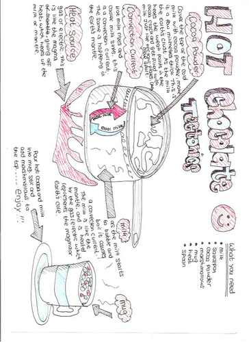
A fun and tasty activity to help students understand plate tectonics and convection currents. Created as a homework activity for my Key Stage 3 and iGCSE geography students in the former Soviet Republic of Georgia, who had English as a foreign language. Younger students may require supervision when making their hot chocolate. Could be a nice activity to do in class, or to cheer up their revision sessions. The worksheet is hand drawn.
Please leave me a review and I will send you any other resource of your choice for free (contact me: office@oceansproject.com). Check out my other resources at my shop: https://www.tes.com/teaching-resources/shop/sarah277
Let me know if you have any resource requests and I will tailor make a resource for you.
A small collection of photos from my time living and working in the country of Georgia.
Please leave me a review and I will send you any other resource of your choice for free (contact me: office@oceansproject.com). Check out my other resources at my shop: https://www.tes.com/teaching-resources/shop/sarah277
Let me know if you have any resource requests and I will tailor make a resource for you.