Thank you for visiting! Here you will find a selection of printable, interactive worksheets for your classroom: Basic Geography worksheets with simple maps, ESL, Spanish, Bible, Reading Comprehension and more. I hope you find the resources useful! Reviews are welcome and very much appreciated. Thank you so much.
Thank you for visiting! Here you will find a selection of printable, interactive worksheets for your classroom: Basic Geography worksheets with simple maps, ESL, Spanish, Bible, Reading Comprehension and more. I hope you find the resources useful! Reviews are welcome and very much appreciated. Thank you so much.
Introduce your learners to Ecuador with this printable handout of two worksheets (plus answer key). Instant download. No prep. Print and go!
This worksheet includes a basic fact sheet about Ecuador with info such as location, climate, currency, language, and national motto, followed by a Cloze Activity / Fill-in-the-blank worksheet.
Thank you for using my worksheets in your classroom! I hope you find them useful. Reviews are welcome and very much appreciated! Please browse this store for more worksheets to introduce your learners to the countries of the world!
Introduce your learners to the books of the bible with this bundle of 13 printable handouts! Challenging but fun, this bundle of printable activities will help your students learn to list (and spell!) each book of the Old and New Testament! Print and Go!
Resources included in this bundle:
-Word Search Puzzle for Old Testament
-Word Search Puzzle for New Testament
-Fill in the blanks of the books of the Old Testament
-Fill in the blanks of the books of the New Testament
-Unscramble the books of the Old Testament
-Unscramble the books of the New Testament
Books of the New Testament: Matthew, Mark, Luke, John, Acts, Romans, 1 Corinthians, 2 Corinthians, Galatians, Ephesians, Philippians, Colossians, 1 Thessalonians, 2 Thessalonians, 1 Timothy, 2 Timothy, Titus, Philemon, Hebrews, James, 1 Peter, 2 Peter, 1 John, 2 John, 3 John, Jude, Revelation
Books of the Old Testament: Genesis, Exodus, Leviticus, Numbers, Deuteronomy, Joshua, Judges, Ruth, 1 Samuel, 2 Samuel, 1 Kings, 2 Kings, 1 Chronicles, 2 Chronicles, Ezra, Nehemiah, Esther, Job, Psalms, Proverbs, Ecclesiastes, Song of Solomon, Isaiah, Jeremiah, Lamentations, Ezekiel, Daniel, Hosea, Joel, Amos, Obadiah, Jonah, Micah, Nahum, Habakkuk, Zephaniah, Haggai, Zechariah, Malachi
Thanks so much for using my worksheets in your classroom! I hope you find them useful. Reviews are welcome and very much appreciated. Please Follow Me for more printables!
Thank you again!
Do your students know all 51 countries of Europe? With this printable activity, your students will fill in the blank letters for each country of Europe! One printable worksheet plus answer key that includes the list of countries in alphabetical order. Print and go!
List of countries included: Albania, Andorra, Armenia, Austria, Azerbaijan, Belarus, Belgium, Bosnia and Herzegovina, Bulgaria, Croatia, Cyprus, Czech Republic, Denmark, Estonia, Finland, France, Georgia, Germany, Greece, Hungary, Iceland, Ireland, Italy, Kazakhstan, Kosovo, Latvia, Lithuania, Luxembourg, Macedonia, Malta, Moldova, Monaco, Montenegro, Netherlands, Norway, Poland, Portugal, Romania, Russia, San Marino, Serbia, Slovakia, Slovenia, Spain, Sweden, Switzerland, Turkey, Ukraine, United Kingdom, Vatican City.
Introduce your learners to each country of Europe one country at a time with a printable worksheet for each country. Each country includes a simple map activity and reading comprehension activities. All available in this store!
Thank you so much for using my worksheets in your classroom. I hope you find them useful. Reviews are welcome and very much appreciated! Please browse this store for more printable worksheets to introduce your learners to the countries of the world!
Introduce your learners to the island of Saint Martin with two printable worksheets (plus answer key). Simple map activity and reading comprehension questions. Instant download. Print and Go!
Your students will read a brief introduction to Saint Martin (location, capital, flag, language), locate and circle the island of Saint Martin on the map of the Caribbean (map 1), trace the dotted line on the map of Saint Martin (map 2) to show the border of Saint Martin (an overseas region of France) and Sint Maarten (an overseas region of the Netherlands), write ‘Marigot’ next to the star on the map of Saint Martin to show the location of the capital, write ‘Philipsburg’ next to the star on the map of Sint Maarten to show the location of the capital, and use the reading passage, maps and compass to answer 9 true/false questions on page 2.
For use with Interactive Notebooks: After the worksheets are completed, students can cut out the map and flags and paste into the notebook under the topic of (example) The Caribbean / Sub-topic: Saint Martin. Under the map, your students can write a summary in their own words of what they now know about this island. Collect worksheets of other countries of the Caribbean to add to the notebook! All available in this store!
Thank you so much for using my Geography worksheets in your classroom! I hope you find them useful. Reviews are welcome and very much appreciated! Please browse this store for more printable worksheets with simple maps to introduce your students to the countries of the world!
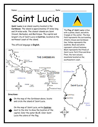
Introduce your learners to Saint Lucia with two printable worksheets (plus answer key). Simple map activity and reading comprehension questions. Your students will read a brief introduction to Saint Lucia (location, capital, flag, language), locate and circle Saint Lucia on the map of the Caribbean (map 1), write ‘Castries’ next to the star on the map of Saint Lucia (map 2) to show the location of the capital, color the map, and use the reading passage, maps and compass to answer 9 true/false questions on page 2. Colored pencils and a pen or pencil are needed for this activity. No other prep needed. Basic Geography worksheet with a simple map to introduce Saint Lucia and practice cardinal and ordinal directions. Print and Go!
For use with Interactive Notebooks: After the worksheets are completed, students can cut out the map and flag and paste into the notebook under the topic of (example) The Caribbean / Sub-topic: Saint Lucia. Under the map, your students can write a summary in their own words of what they now know about this country. Collect worksheets of other countries of the Caribbean (or North America) to add to the notebook! All available in this store!
Thank you so much for using my Geography worksheets in your classroom! I hope you find them useful. Reviews are welcome and very much appreciated! Please browse this store for more worksheets to introduce your learners to the countries of the world!
Included: Petite Piton and Gros Piton.
SPED, Resource Room Teacher, Primary school, elementary.
Introduce your learners to the countries, states and regions of the of the world with Geography Word Search Puzzles!
Your students will use the map to find the names of countries, states, regions, lakes and more in the Word Search Puzzle! Print and Go!
Word Search Puzzles included in this bundle:
Albania
Greece
Italy
African Great Lakes
Central America
Equator
Germany
Ireland
Malaysia
Armenia
Middle East
Oceania
France
Spain
South America
Caribbean Islands
The Continents
Sahara Desert
The Stans
United States
Thank you so much for using my worksheets with your learners! I hope you find them useful. Reviews are welcome and very much appreciated. Please browse this store for more printable worksheets with simple maps to introduce your learners to the countries of the world!
Color the map of Europe. Printable handout of 1 page includes a map of Europe to color and learn.
Countries of Europe included: Albania, Andorra, Armenia, Austria, Azerbaijan, Belarus, Belgium, Bosnia and Herzegovina, Bulgaria, Croatia, Cyprus, Czech Republic, Denmark, Estonia, Finland, France, Georgia, Germany, Greece, Hungary, Iceland, Ireland, Italy, Kazakhstan, Kosovo, Latvia, Lithuania, Luxembourg, Macedonia, Malta, Moldova, Monaco, Montenegro, Netherlands, Norway, Poland, Portugal, Romania, Russia, San Marino, Serbia, Slovakia, Slovenia, Spain, Sweden, Switzerland, Turkey, Ukraine, United Kingdom, Vatican City.
Thank you for using my Geography worksheets in your classroom! I hope you find them useful. Reviews are welcome and very much appreciated. Please browse this store for a selection of worksheets to introduce your students to the countries of the world!
This printable map of Asia includes all 50 countries (list below). 1 printable page. Prints in black and white. Instant download. Print and go! Use as a reference or print to color and learn! and learn the map of Asia with this printable coloring page.
Countries included: Afghanistan, Armenia, Azerbaijan, Bahrain, Bangladesh, Bhutan, Brunei, Cambodia, China, Cyprus, Georgia, India, Indonesia, Iran, Iraq, Israel, Japan, Jordan, Kazakhstan, Kuwait, Kyrgyzstan, Laos, Lebanon, Malaysia, Maldives, Mongolia, Myanmar, Nepal, North Korea, Oman, Pakistan, Palestine, Philippines, Qatar, Russia, Saudi Arabia, Singapore, South Korea, Sri Lanka, Syria, Taiwan, Tajikistan, Thailand, Timor-Leste, Turkey, Turkmenistan, UAE (United Arab Emirates) , Uzbekistan, Vietnam, and Yemen. Also the Arctic Ocean, Pacific Ocean, Indian Ocean and surrounding parts of Europe and Africa.
Thank you for using this printable map of Asia with your learners! I hope you find it useful. Please browse this store for more printable worksheets with simple maps to introduce your students to the countries of the world!