I'm a teacher and the Author of the Amazon e-book;' Time Smart Teaching' and my mission is to create Geography resources to help teachers save time and reduce their workload. I am sharing additional time saving tips for teachers on my YOUTUBE channel ' Time Smart Teaching' if you fancy dropping by!
I'm a teacher and the Author of the Amazon e-book;' Time Smart Teaching' and my mission is to create Geography resources to help teachers save time and reduce their workload. I am sharing additional time saving tips for teachers on my YOUTUBE channel ' Time Smart Teaching' if you fancy dropping by!
This 4th lesson in our cold climate series ’ Pole to Pole’ allows students to discover Antarctica through a virtual Antarctic cruise. They will learn to annotate the Antarctic icy landscape and discover what tourist activities away those on the cruise. We also compare how the Arctic is different from the Antarctic using a true or false quiz- the students find the answer by studying and comparing the 2 maps of the poles.
Volcanoes are weak points in the earth’s crust where plate boundaries appear, and periodically let lava escape to the surface. these can also be found at hotspots. For the GCSE Geography AQA curriculum students need to be aware of 2 main types of volcanoes, where and how they form, and their distinguishing characteristics. this PowerPoint lesson resource assumes a basic level of existing understanding and recaps on the basic structure and eruption characteristics of each. there is a BINGO starter game linked to a video resource. Added challenge for higher ability to explain 3 of their bino words to the group. Following on from this the teacher can talk through the next slides, on parts of a volcano and its layered structure and associated hazards. or print the information out ready for the TRUE or FALSE activity/ grid, which has answers attached. At the end students are prompted to think about which celebrity embodies each type of volcano the most. This is to help them memorize and make connections to enegage in their long term memory for the examinations. Approx lesson length: 45 minutes.
This full lesson gets students thinking about describing and explaining where most of the world’s ice is found. The Tundra biome is found at far north and south latitudes where the days are short and the winters are long. Permafrost and taiga forests are located here and only well adapted plants and animals survive, hence the name ’ treeless mountain tract’. The lesson has a differentiated map task where student must shade and label places within the tundra biome. There is also a match-up activity where they must link up definitions of icy landscape features with their pictures: glaciers, ice sheet, ice caps and snow patches.
Using a simple 3d slot- in Christmas tree template, this will keep your kS3 geography classes happy and crafting in the festive season. The Christmas tree templates have been adapted on photoshop to show a choice of 3 designs; maps of lapland, images of biomes and flags of the world. Student can also use a blank template to record and reflect on their geographical learning from accross the year. These templates could also easily be used to make geographical themed christmas bunting! Simple and easy to do, but effective and would make a lovely set of classroom displays, ideal for open evenings. These designs will work well photocopied in black and white, and students can add colour themselves to extend the activity and keep photocopying budgets down.
A bundle of examination support resources created for the 2019 summer examination pre-release material about road building through the Peru Amazon. The bundle includes an A3 revision poster plus workbooklet to help students analyse each page of the booklet. IN addition there is a revision poster on Tropical Rainforest management.
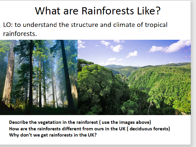
This full lesson combines sketching skills and reading comprehension to annotate a diagram of the different rainforest layers: forest floor, understory, canopy and emergent layer. Tropical rainforest biomes are found around 0 degrees lattitude, also known as the equator. Almost all GCSE geography examination boards expect students to have a detailed understanding on the layers and features of the rainforest. This lesson includes a kinathstectic mini-quiz to test students understading on each of the layers; they move around the 4 corners of the room to classify statements on each of the different layer characteristics.
Hot deserts are known for their harsh climates and unforgiving landscapes, yet their are economic and environmental opportunities in these regions in you look closely enough. Water and resource management becomes even more important in the Sahara as drought and desertification takes hold.
This 4 lesson bundle covers everything your students need to know about a desert case study for their examination on the ‘Living World’/ Ecosystems’ topic for the AQA exam board specification. The first lesson analysis the climate of the Sahara using a living graph to cut and stick statements around. The second lesson focuses on hidden resources in the Shel, such as oil, minerals and hidden underground aquifers. Students make a chloropeth map to show where these are found. Students will also take part in group work to present to the class about how different plant and animal life has adapted to the harsh conditions of the Sahara desert. In addition, they will sort statements into a venn diagram to classify the various human causes of desertification (climate change, agriculture or population pressure) before summarising their notes into a mindmap. Finally, they will examine a range of approaches in use to combat desertification, and write up a full report of their findings. By the end of these resources you students will have a sound and detailed understanding on the concepts of;
Desertification
Adaptions
Economic opportunities
Social, economic and environ
aggroforestry
They will also attempt exam questions such as;
Explain the human causes of desertification
Explain how the desert climate impacts upon the people living there
Most countries devise their electricity generation mean through a mix of fossil fuels and renewable energy resources. This A3 revision poster gets students analysing energy mix trends from pie charts located onto the world map. The original map is available as a free download from the EDF energy website; edfenergy.com/energy/education however a large copy is made available on the second slide of the powerpoint. Students answer prompt questions onto the A3 sheet around a copy of the pie-chart map, such as ’ describe the UK’s energy mix’ and also ’ compare the energy mix between the USA and Brazil.’ There are questions designed to make student connect more broadly to the topic ’ Challenge of Resource Management. The energy mix section on this topic is core contact, therefore important for all students to understand. These would make ideal classroom displays or as independent revision work in the lead up to examinations. This worksheet is designed for middle to higher ability students but could be easily adapted for lower abilities with a few prompts/ sentence starters here and there.
The river Tees flows for 85 miles through Northern England from Cross Fell in the Pennines, to the North sea near Middlesbrough. It shows typical valley features of the long profile of a river and is an important example to study for the new AQA GCSE Geography curriculum. This 6 part storyboard activity allows students to make notes independently at key stages along the river’ journey from the BBC bitesize website amongst others. This was written for lower to middle ability students in mind to give them lots of visual references to remember key facts about the river Tees. There are 3 exam type extension questions at the bottom of the worksheet to stretch the more able students in the class. To complete the task they must show skills such as field-sketching, map reading and comprehension.
Advent calendars are traditionally associated with the December count down to 25th, Christ’s birthday. At the end, kids can look forward to earnings their biggest chocolate on Christmas day. This advent calender is perfect to use with years 7 8 and 9 in the final classes before the festive break. These can be used as mini starters, or take up the whole lesson. The answers to the questions on each day are provided, so make sure you have small chocolates or candy to give out for any students who complete and self mark their quiz. There is a mixture of vocab, general knowledge, map skills, locational knowledge throughout plus all important literacy. anagrams. Use this resource in conjunction with my original ’ 3D stand up geography christmas trees’ to get a fabulous festive geography display going in your classroom.
This lesson looks at why earthquakes form at destructive, constructive and conservative plate margins. Student develop key paper 1 examination skills by learning to draw and annotate diagrams to explain how friction build up and release results in tremmors in the earth’s crust. There is a bonus powerpoint which has an earthquake maps/ GIS/ proportional circle graph analysis, which students have to answer questions on.
This is a short ( 3 mins approx) mid-unit test to check students understanding on the concept of sustainable tourism. It could also easily be set as a classwork or homework task. Students must show they can define sustainable tourism, explain the negative impacts of mass tourism, and annotate an ecolodge with its sustainable features. This was originally written for year 9 as an introduction to the Unit 1 travel and Tourism Btec course ( and unit 1 examination). It could also easily be used for Ks3 Geography. Would go well with my other resource on ’ Sustainable tourism & Ecolodges’.
This lesson introduces the concept of ‘sustainable toursim’ and then students are given a task of designing an eco-lodge according to the principles of sustainability. there is a peer assessment grid to judge the sustainability of pupil designs. This lesson was made for the Unit 1 examinatioin for Btec Travel and Tourism, but equally as good for Ks3 Geography.
The geology of a coastline will have an impact on how quickly it retreats backwards due to the erosion processes off hydraulic action and abrasion. This lesson considers how the aspect, rock type, layers and existing sea defenses all contribute to different rates of erosion. The meanings of the terms lithology, concordant and discordant coastlines are apparent throughout the lesson. This lesson was designed initially for an interview, and worked really well for a 50 minute lesson duration.
starter: Students examine the picture and discuss what is happening to the houses and why. They then compare two coastlines; Durdle Door and Swanage Bay, and predict which one they think will retreat the quickest, with the aid of maps.
Main - students annotate their images/ maps with information about the geology of each coastline, from either the teacher talk or print-outs from the slides. they can be encouraged to do their own research also at this point. Then they attempt a 4 mark exam question designed to test their understanding of the geology and how it influences coastal erosion.
plenary- a gap fill exercise on an image to test students recall on the main factors discussed in the lesson.
This powerpoint resource offer a series of 8 starter activities, each designed to develop a particular critical thinking skill in students such as meta cognition, assessing importance of different view-points and sources. Each skills-based task is set in the context of human-based Geography, largely connected to the AQA Specification A topic of ‘Urban Issues & challenges’ but does also encompass wider synoptic links to other parts of human geography. Each skills based starter can be done as a stand alone activity, or all 8 skills could be done together in one lesson as a revision session for Paper 2 Human Geography. The importance of critical skills to exam success is implied throughout, and at the end, the final task asks students to analyse past exam questions and identify which of the critical skills taught will be useful to answering the question set. This resource is aimed at middle to high ability learners.
This resource is designed for a quick recap across all 3 of the Human Paper topics: Urban Issues and Challenges, The Challenge of Resource Management and Changing Economic World. It is made up of a series of 20 questions on each topic ( 60 in total) which only require brief answers ( 1 -2 marks) and is taken from across a broad range of the specification, focusing on the CORE elements. It has been designed for last minute revision and can be done in class or at home. It would be useful for students to complete with access to the BBC bitesize revision website or a revision guide to ease speed of completion. Most of the command words are give, identify, outline, describe etc. Please note these are questions only without answers/ mark scheme.
I love to spend a lesson doing these reflection activities at the end of a half term or unit of work. These are ideal for lower year groups, 7 and 8, but possibly could be used for junior years at primary school too. I set these when I want some feedback on my topic and also some time to get some assesment marking done. For those that finish early ask them to mount their sheet onto coloured sugar paper and draw a fancy border, alternatively print double-sided with a geography themed colouring page/ map on the reverse. Keep completed copies for displays and to bring out at open evenings.
This worksheet builds on the basic map skills once they have been taught and is designed to stretch and challenge middle and higher ability students to interpret maps and images and create contour maps. They will need to 1. create a contour map of Mordor, 2. Use colour to shade the relief onto their map or image and 3. Use compass directions to see where will be effected if mount doom volcano erupts. For middle ability sets the teacher may need to help the students get started by drawing some contour lines onto the whiteboard to represent gentle hills, steep volcano and flatter areas as they may find this tricky.
This series of activities gets students to use their maps, graphs and numeracy skills to learn about the Rio Olympic Games in 2016. It can be done as a lesson using the powerpoint slides or set as a homework activity using the publisher document and printing in large A3 size. The posters look fantastic on display and is sure to gain attention from SLT and ofsted while you develop cross curricular links with maths. On the poster there is a simply AFL tool- teachers can circle or tick whether the work gets bronze, silver or gold award. Ideal for any Ks3 grouop- originally written for year 8.
I have adapted the famous game of connect 4, where 2 players are pitted against each other to connect 4 coloured ’ disks’ into adjacent slots vertically, horizontally or diagonally. Each player needs to give the correct answer before being allowed to colour in their disk. 2 players can fill in the same sheet, or ideally laminate the blank board for multiple uses with non-permenant markers and save your photocopying budget. Great for all ability ranges and engaging less motivated student with physical Geography content for the paper 1 AQA GCSE examination. Questions cover changes and processess along the long profile of a river plus definitions for drainage basin features.