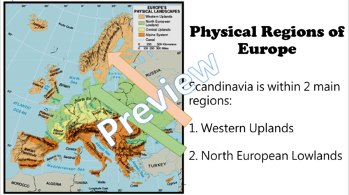


The third of seven engaging lessons which bring Scandinavia into the classroom. Discover interesting information, amazing videos and differentiated activities while covering key KS2 National Curriculum geography and English objectives. Teach an effective lesson with no preparation necessary, just glance through the PowerPoint and you’re ready to go.
This is written for KS2, ideally for years 4, 5 and 6 but could be easily adapted for year 3.
This lesson covers these important teaching points:
- What physical regions are in Scandinavia? Map analysis
- What physical features are in Norway, Denmark and Sweden? Images and explanations for each
- Who can remember these? Video analysis for AFL
- What have we learnt? Children to show by explaining each map
- Which country is this?Children to use their learning to figure out the images
All resources are included, so just print the maps and a detailed lesson plan and your lesson is ready.
All lessons in this unit are designed to link to and extend work in English with challenges linking to English objectives, e.g. persuasive writing features.
All reviews welcome.
To teach Scandinavia throughout the curriculum, download my English and art units:
You can find many more engaging and high quality resources at my Teachallenjoy Shop
Get this resource as part of a bundle and save up to 43%
A bundle is a package of resources grouped together to teach a particular topic, or a series of lessons, in one place.
Something went wrong, please try again later.
Quality resources including video links saving precious time for a busy teacher. Easy to modify for age groups. Thanks a lot - great for my wellbeing too!
Report this resourceto let us know if it violates our terms and conditions.
Our customer service team will review your report and will be in touch.