I am a Geography specialist who has also been teaching GCSE history for the past few years. I have uploaded some lessons for History and Geography. I hope people find them useful.
I am a Geography specialist who has also been teaching GCSE history for the past few years. I have uploaded some lessons for History and Geography. I hope people find them useful.
AQA GCSE Geography lesson for the new specification Unit 2B: In this lesson we look at the environmental impacts of quarrying in the UK.
The lesson starts with a quick true or false retrieval practice quiz with sound effects. We then look at a photo of a quarry and the pupils think about all the impacts the quarry may be having on the physical environment. There are possible answers on the next slide. We then look at ways that industry might be able to become more sustainable. The pupils have hexes and are asked to develop the points further by explaining their potential impacts. There are suggestions on the following slide. We then look at quarrying and Torr Quarry as an example. The pupils have an info sheet and a knowledge organiser to complete with questions relating to Torr Quarry and Quarrying. There is also a video clip on quarry restoration to help with this section. We finish with a 4-mark practice question with some guidance on how to respond.
Hope this saves you some valuable planning time.
https://www.tes.com/teaching-resources/shop/markthegeographer
Power & the People lesson on the Chartists. In this lesson we introduce the Chartists and Chartism. We then look at what the demands of the Chartists were and how they believed they would make for a fairer electoral system. We then examine the methods of the Chartists and how they were successful at spreading their message. We then look at the failure of Chartism and examine the reasons for this before finishing with how significant the movement was in the end. Included in the lesson is:-
Question starter around Secret Ballots
Activity on the Chartists Six Point Demands
Video Clip
Activity examining the methods of the Chartists
Writing activity on the failure of Chartism
Question on the significance of Chartism.
Hope this helps
https://www.tes.com/teaching-resources/shop/markthegeographer
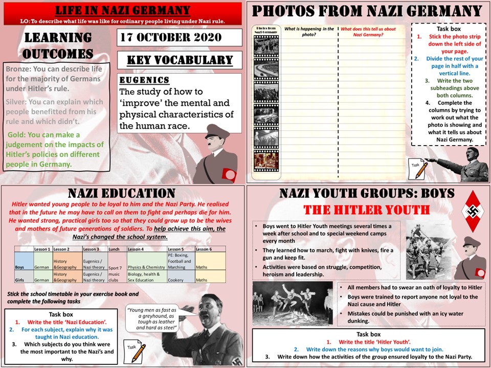
Key Stage 3 lesson for a scheme of work on The Rise of The Dictators. In this lesson we look at what life was like for people living in Nazi Germany. We start with an activity called ‘Photos from Nazi Germany’. The pupils try to work out what is going on in the photos and what this tells us about life in Germany at this time. We then look at life for different types of adults, we use an evidence sheet and the pupils make notes about how those people perhaps benefited, or suffered under Nazi rule. We then look at young people. We start by analyzing a school day fro the German school pupil and why the Nazi’s wanted certain subjects to be taught. We then look at the Hitler Youth and the league of German Maidens and why young people were drawn to these groups and what purpose they served the Nazi’s
I hope this proves useful and saves you some time.
https://www.tes.com/teaching-resources/shop/markthegeographer
AQA GCSE Geography lesson for Unti 1A: The Challenge of Natural Hazards. there is a retrieval practice starter grid which will just need filling out by the teacher with appropriate questions. Pupils begin by looking at the location of earthquakes and volcanoes by plotting their location on a map using longitude and latitude. Pupils then describe the pattern using T.E.A (trend, examples, anomaly). We then look at the plates and margins. The pupils use description of the plates locations to work out where they are then descriptions of their movements to draw on arrows of the plates direction of travel. We examine the link between the locations and plate margins and briefly explain the anomalies by looking at hotspot volcanoes. We then tackle a GCSE-style question with guidance for the pupils if needed.
In a nutshell lesson includes:
Retrieval practice starter
Longitude and latitude skills task plotting tectonic hazards
Map task using descriptions of plate locations and movements
Hotspot diagram drawing
GCSE-style question with guidance.
Hope this saves you valuable planning time.
https://www.tes.com/teaching-resources/shop/markthegeographer
A Key Stage 3 lesson for Religious Studies on Christmas. This resource is perfect for Christmas Cover work or just a final lesson before the holidays. There is a variety of activities for the pupils to undertake all with a Christmas theme which may involve research, creativity and revision.
The sheets are best printed off as A3 sheets, double sided, but if lessons are short (45-50 mins) you could just use one side of the sheet. When using both sides it is a good double lesson or two single periods.
https://www.tes.com/teaching-resources/shop/markthegeographer
AQA GCSE Geography lesson for the new specification Unit 2A: In this lesson we look at the environmental challenges of urban sprawl and housing provision in London.
We start with a retrieval practice grid with questions based on the London unit so far (but you just amend to whatever you want).
We then look at what urban sprawl is, we then consider the advantages and disadvantages of urban sprawl in a spray diagram. The pupils are given some sentence starters to help them consider what they might be. We move on to consider if there is a housing shortage in London. We use house prices as a proxy for this and the pupils spend some time working with a graph of house prices and completing some questions related to the graph.
We then consider the options London has of developing on either brownfield or greenfield sites. The pupils complete a photo annotation task on the two types and what the advantages and disadvantages of building on both types are. We then move on to a mapping activity where the pupils map the available greenfield and brownfield sites for development. They answer some questions related to London’s options to solve its housing problems and what the impact on the environment might be.
Once we have completed the diagram we tackle a 6-mark question on the effects of urban sprawl on the environment and people. There is guidance should the pupils need it.
In a nutshell lesson includes:
Retrieval practice starter
Benefits and drawbacks of urban sprawl diagram task
Greenfield and brownfield photo annotation task
Video clips where appropriate
Mapping London’s greenfield and brownfield sites task.
GCSE-style question with guidance or live writing exercise.
Hope this saves you some valuable planning time.
https://www.tes.com/teaching-resources/shop/markthegeographer
AQA GCSE Geography lesson as part of the Nigeria: A Newly Emerging Economy unit. The lesson is roughly one hour long but can be shortened or extended. In this lesson we introduce the concept of a TNC. We then do a quick activity on the incentives for TNC’s to locate their operations in different countries. The pupils then complete a sorting exercise on the problems and benefits of TNC’s in general before we look at Shell’s operations in the Niger Delta. The pupils create a visual chart to show the overall benefits and costs, but also the extent to which those factors are benefits or costs. We then go on to answer a 6 mark question with a structure strip for support. Included is:
Starter on TNC’s in Nigeria
Exercise on incentives for TNC’s in countries
Sorting activity on costs and benefits
Costs and benefits chart on Shell Oil
GCSE style question with structure strip
Hope this helps.
https://www.tes.com/teaching-resources/shop/markthegeographer
AQA GCSE Geography lesson from the Nigeria: A Newly Emerging Economy Unit.
The Lesson needs the Oxford AQA GCSE Geography textbook
The lesson is roughy one hour long, but can be extended or shortened, The lessons starts with an annotation exercise on an image of slums in Lagos. The pupils explore the environmental problems in the image and potential causes and solutions. We then take a short look at a video clip of an illegal oil extraction operation in the Niger Delta and asked how rapid developemnt may have led to this. The pupils then move onto an A3 information gathering task usingthe Oxford textbook. The sheet is differentiated with a variety of tasks. We then finish the lesson by attempting to answer a 6-mark question on environmental issues with guidance and structure if the pupils need it. Included is:
Photo annotation starter
Two relevant video clips
A3 information organiser task
GCSE question with structure and guidance.
Hope this helps.
https://www.tes.com/teaching-resources/shop/markthegeographer
AQA GCSE Geography lesson for the Hot Deserts section. The lesson is roughly one hour long. We start with a quick retrieval practice true or false. We then look use some information cards on the methods for reducing desertification. The students complete a varied activity worksheet using the cards for help. We then move on to tackle a GCSE-style question on this topic with guided structure if you want to use it with the pupils. Included is
True or False retrieval starter
Information cards to print
Worksheet activity
GCSE-style question with writing frame.
Hope this helps.
https://www.tes.com/teaching-resources/shop/markthegeographer
AQA GCSE Geography lesson for the new specification Unit 2A: In this lesson we look at the emergence of megacities and the reasons for urbanisation.
We start with a quick photo starter of Tokyo. We introduce the two concepts of natural increase and rural-urban migration. The pupils have a worksheet to fill in regarding push/pull factors, firstly adding their own ideas, then with some input from the teacher, then they categorise into social, economic and environmental.
We then look at megacities, with a introductory video. the pupils then plot the location of the megacities as of 2018 using longitude and latitude coordinates. The pupils then have some extension tasks around their map. We then have a brief interlude to consider what living in a megacity might be like and watch a short clip on Tokyo and living in such a high density population. We then finish with a comparison of a map showing megacities from 1975 and answer a GCSE-style question.
In a nutshell lesson includes:
Photo starter
Video clip
Push/pull worksheet exercise with questions.
Long & lat skills task followed by map interpretation.
Video of Tokyo
GCSE-style question using map with guidance
Plenary quiz
Hope this saves you some valuable planning time.
https://www.tes.com/teaching-resources/shop/markthegeographer
AQA GCSE history lesson on how the assassination of Franz Ferdinand start a chain reaction of declarations of war in 1914.
We start with a simple retrieval practice quiz. We then have a brief recap of the murder of Franz Ferdinand in Sarajevo. The pupils have a picture source to look at. We then look at Austria-Hungary’s demands of Serbia. The pupils record the demands and explain how acceptable the demands are to Serbia. We then look at the events of the July Crisis is a sequence of slides. The pupils will record the tension levels in Europe as the events progress by creating a bar chart until a pan-European war is declared. The pupils then revisit the alliance source (a threatening situation) and answer some questions based on the source. We finish with a 16 mark “To what extent” question with some guidance on what the pupils can write about.
Hope you find this useful and it saves you some planning time.
https://www.tes.com/teaching-resources/shop/markthegeographer
AQA GCSE Geography lesson for the latest specification Unit 1B: In this lesson we look at the processes of weathering, erosion, transportation and deposition in glacial environments.
The starter is just a quick photo mystery around glacial deposits.
We then look at the extent of the ice sheet during the Last Glacial Maximum (LGM). We introduce freeze-thaw weathering as the principle type of weathering in glacial environments as the pupils create a sequential diagram. The pupils are provided with a diagram to annotate for the processes of abrasion and plucking. We watch a video on the transportation of material by the glacier and the pupils create a diagram. They then construct a paragraph on transportation by guessing the missing words using the picture prompts. They also construct a paragraph on deposition based on sentence fragments. We finish with a 4 mark GCSE-style exam question with guidance on how to answer it.
Hope this saves you some valuable planning time.
https://www.tes.com/teaching-resources/shop/markthegeographer
Key Stage 3 lesson on comparing and contrasting Richard I with Saladin. The lesson would take about two periods to cover fully, but can easily be shortened. We start by thinking about what makes an effective leader during the medieval period.
we then introduce the two leaders and the pupils will read the story of each leader before creating a character card that assesses the leaders strengths and weaknesses. We then go on to look at how the two men are similar and different by creating a Venn diagram. Finally there is an extended writing task where the pupils explain their choice of leader through evaluating their actions. Included in the lesson is:
Starter activity
Character card templates and information sheets on the leaders
Venn diagram task
Extended writing task with writing frame and support.
Plenary.
Hope this helps.
https://www.tes.com/teaching-resources/shop/markthegeographer
Key Stage 3 History lesson which is at least two hour-long lessons. We start with a photo interpretation starter “Why is Simon’s Head in the Wall?”. The pupils try to deduce what happened to Simon of Sudbury. We then go onto to watch a video clip on the Peasants Revolt. The pupils have a crib sheet to fill in as the video plays. We then look at the events of the peasants revolt where the pupils complete an activity that involves summarising events and drawing symbols and diagrams. using the information the pupils have gained they then design a movie poster for a film about the Peasants Revolt where the pupils can show their knowledge and be creative!
In a nutshell the lesson includes.
Photo interpretation starter
Video clip with crib sheet
Events of the Peasants Revolt activity
Design a movie poster task
Plenary.
Hope this saves you some valuable planning time.
https://www.tes.com/teaching-resources/shop/markthegeographer
AQA GCSE Geography lesson for the new specification Unit 2A: In this lesson we look at how Lagos has grown in the last 50 years and why.
We start with a population pyramid of Nigeria and the pupils can choose questions to answer as we explore the population structure of the country.
We then look at the growth of Lagos through the pupils plotting the data onto a graph and answering questions about Lagos’ population growth. We then move onto the physical growth of the city. Here pupils use colours to make an isoline map and again there are questions for the pupils to answer. We then look at push & pull factors for rural-urban migration. The pupils create a graph as a visual tool to see which are the main pull and push factors. We finish with an emoji annotation plenary about the reasons for Lagos’ population growth.
In a nutshell lesson includes:
Population pyramid starter
Video clip
Graph plotting task with questions on population data.
Isoline map task with questions.
Push-pull factors bar chart.
Annotating emojis plenary.
Hope this saves you some valuable planning time.
https://www.tes.com/teaching-resources/shop/markthegeographer
Third lesson on the Norman Conquest. This 1 hour lesson looks at the events of the Battle of Fuford and then we look at the Battle of Stamford bridge and try to work out the main reasons for Harold Godwinson’s victory and Hardrada’s loss. All the lessons and resources are provided as are the video clips. Included is
Bayeux tapestry question starter
Video crib sheet for the Battle of Fulford
Activity on the events of Stamford Bridge
Video clip on Stamford Bridge
Writing evalaution activity.
Hope this helps.
https://www.tes.com/teaching-resources/shop/markthegeographer
AQA GCSE Geography lesson for The Changing Economic World section. Lesson one in the Nigeria SOW. The lesson is over one hour long, but can be adapted.
We first look at the location of Nigeria and pupils complete some skills work around describing the location. We then continue to examine Nigeria’s global importance whilst the pupils complete an knowledge organiser. Then using demographic data the pupils examine Nigeria’s population whilst practicing some graphical skills. We then look at the importance of Nigeria in Africa. Included in the lesson is:
Differentiated activity on Nigeria’s Location
Knowledge organiser on Nigeria’s global importance
Graph skills worksheet on Nigeria’s Demographics
Activity on Nigeria’s importance in Africa.
Hope this helps.
https://www.tes.com/teaching-resources/shop/markthegeographer
For AQA GCSE Geography. You need the Oxford AQA GCSE Geography Textbook for the new specification
The lesson includes.
Photo interpretation starter.
Questioning activity
Video clips
Large A3 worksheet with a variety of different activities covering the required content.
Plenary activity.
All worksheets for photocopying included. Hope this helps.
https://www.tes.com/teaching-resources/shop/markthegeographer
AQA GCSE Geography lesson for the new specification Unit 1A: In this lesson we look at what extreme weather is, what type of extreme weather the UK experiences and whether the UK may experience more in the future.
The lesson has a retrieval practice starter where the pupils choose the places or the circumstances where tropical storms can be found. We then look at the definition of extreme weather. The students complete a map exercise which helps to explain why the UK’s geographical location allows a variety of extreme weather to be experienced. The students then complete a spider diagram on the types of extreme weather, there are some video clips and information slides to help with this which could be a carousel activity. We then complete a map exercise where the students use an atlas to locate where the extreme weather impacted and evaluate how severe the weather event was. We finish with a GCSE-style practice question with some guidance and structure provided for the students.
Hope this saves you some valuable planning time.
https://www.tes.com/teaching-resources/shop/markthegeographer
AQA GCSE Geography Lesson from the Nigeria: a Newly-Emerging Economy section. The lesson is roughly an hour long. We start with a photo showing an illegal crude oil refinery in Nigeria and discuss what this reveals about he country and its natural resources. We then look at Nigeria’s political links to other organisations such as OPEC and the United Nations. We ask which of these are most significant to Nigeria’s development. We then look at Nigeria’s two main exports sectors, crude oil and agriculture where the students annotate a text extract to show their understanding. We then look at where Nigeria’s exports of crude oil go to by creating a flow line map. We then answer a GCSE style question worth 6 marks with guidance should the students need it. Included is:
Photo interpretation starter on illegal crude oil refinery
Sorting activity on political links
Text extract annotation task on crude oil and agriculture
FLow line map activity
6 mark GCSE stye question with guidance.
Hope this helps.
https://www.tes.com/teaching-resources/shop/markthegeographer