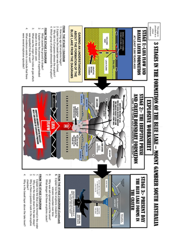


This unit has a focus on the creation of 4 volcanic crater lakes formed between 4000 and 5000 years ago. Through a series of labelled diagrams you will be able to explain the formation stages. The unit ties into the explanation of Aboriginal People who must have witnessed the eruption and the formation. Their story of explanation is added. Mount Gambier owes much of its tourist appeal to the presence of these crater lakes inside the volcanic rims which form a backdrop[ to the city. By broadening the area and studying the map between the two capitals of Adelaide (South Australia) and Melbourne (Victoria) the central position of Mount Gambier provides another reason for tourist stopovers. Broaden the study and Mount Gambier is adjacent to two locations of world significance - the fossil rich Naracoorte caves (World Heritage listed) and Penola which is a location of significance in the story of Saint Mary MacKillop. There are several attachments for you to use dealing with the formation process; the visit to the craters and a summary test sheet with cut and paste graphics. These graphics are clearer in the colour versions but if that isn't possible I suggest you project the colour images and discuss them. This area of South Australia deserves to be a significant tourist attraction which you will understand when you cover the material.This unit supports Destination and Location studies (UK); Natural disasters and landforms studies (Australian Curriculum). It's a bit of a pity that you will be several thousand years late to witness the volcanic eruptions.
Something went wrong, please try again later.
This resource hasn't been reviewed yet
To ensure quality for our reviews, only customers who have downloaded this resource can review it
Report this resourceto let us know if it violates our terms and conditions.
Our customer service team will review your report and will be in touch.
£0.00