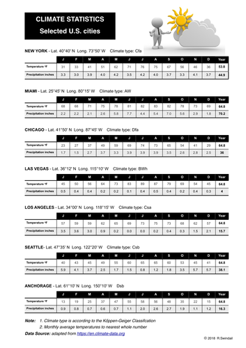
Three pages - first page is a table of climate statistics (temperature in fahrenheit, precipitation in inches) for seven US cities with different climate classification; second page is a worksheet for student to use the climate statistics to draw climate graphs for each city and to locate them on a map of the U.S.; third page is an answer key with graphs drawn and cities located on the map of the U.S.
Something went wrong, please try again later.
This resource hasn't been reviewed yet
To ensure quality for our reviews, only customers who have purchased this resource can review it
Report this resourceto let us know if it violates our terms and conditions.
Our customer service team will review your report and will be in touch.
£2.00
