Hero image

GeographyFocus Shop

Average Rating4.55
(based on 40 reviews)

I am a geography teacher with 36 years experience in Years 7 to 12 in high schools in New South Wales and Western Australia. I am now retired but maintain a strong interest in producing resources for the subject for which I have a passion. This shop features a range of geography resources suitable for upper primary school and high school. Free resources are available for you to use within your school to trial the quality of my work.

121Uploads

95k+Views

9k+Downloads

I am a geography teacher with 36 years experience in Years 7 to 12 in high schools in New South Wales and Western Australia. I am now retired but maintain a strong interest in producing resources for the subject for which I have a passion. This shop features a range of geography resources suitable for upper primary school and high school. Free resources are available for you to use within your school to trial the quality of my work.
Hurricane Michael - October 2018 (a geographical enquiry)
swintrekswintrek

Hurricane Michael - October 2018 (a geographical enquiry)

(0)
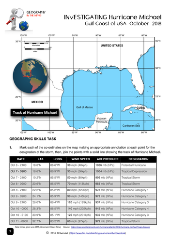
This is a worksheet (3 pages) that will get your students to investigate Hurricane Michael (October 2018). The first page is a latitude and longitude exercise where the students will be the meteorologist and map the track of the hurricane from its beginning in the waters of the Yucatan Peninsula to its arrival at the Florida Panhandle. On the second page students will answer general questions on hurricanes as background to the third page where they will look at the impact of Hurricane Michael more closely. The worksheet is best suited for lower high school but could be used at a higher level. An answer sheet is provided for teachers as a separate file.
Water in the World: Water as a Resource
swintrekswintrek

Water in the World: Water as a Resource

(0)
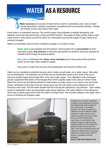
Five pages: first page is text on water as a resource with the other four pages learning activities that ask students to investigate the use of water as a resource. Produced for the Australian Curriculum Geography topic “Water in the World”. May also be useful in other jurisdictions where water is part of the geography curriculum.
Investigating Plate Tectonics
swintrekswintrek

Investigating Plate Tectonics

(0)
This worksheet requires students to investigate the basic ideas behind plate tectonics by looking at the website given in the worksheet. They will be required to answer the questions and complete simple diagrams on the worksheet that are available on the website. Finally they are given three questions at the end of the second page to prepare for a discussion in class - questions are not shown in the preview, but they are: 1. If your school was located towards the middle of a tectonic plate would this have implications for you? YES/NO. Explain your answer. 2. If your school was located near the edge of a tectonic plate what natural hazards could you be affected by? 3. How could you prepare for these hazards?
World Solar Challenge - a geographical inquiry into outback Australia
swintrekswintrek

World Solar Challenge - a geographical inquiry into outback Australia

(0)
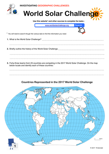
This is a 3-page worksheet that requires students to investigate the 2017 World Solar Challenge in outback Australia. Students are taken to the world solar challenge website and asked to answer questions from the given information. Page 2 gives the students climatic data for Darwin, Alice Springs and Adelaide and gets them to construct climate graphs. Page 3 asks them to use the internet to find geographical information on the towns that the Challenge passes through in preparation for a class discussion.
Counties of England Bundle
swintrekswintrek

Counties of England Bundle

6 Resources
Set of Wordsearches with accompanying map exercises for the counties of England. Each of the six sets of counties has three differentiated word searches for the varying abilities of students in your class (a total of 18 wordsearches in the bundle). These wordsearches and map exercises are a fun way for your students to learn the names and locations of the counties of England.
Water in the World: the value of water to different cultures
swintrekswintrek

Water in the World: the value of water to different cultures

(0)
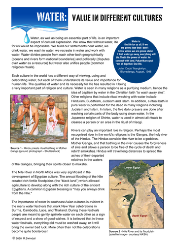
One page of text explaining the value of water to different cultures followed by three learning activities that require students to answer questions based on the text, use provided websites to investigate the significance of rivers to different cultures, and finally to investigate the value of water to Australian Aboriginal groups.
Hurricane Dorian Enquiry
swintrekswintrek

Hurricane Dorian Enquiry

(0)
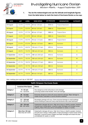
An enquiry into Hurricane Dorian August/September 2019. Students use latitude and longitude to track the path of Hurricane Dorian, investigate hurricanes in general and the impact of Hurricane Dorian on the Bahamas. An answer key is provided.
Eastern Australia Floods March 2021
swintrekswintrek

Eastern Australia Floods March 2021

(0)
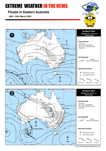
A series of two synoptic charts and three worksheets that introduce students to floods and investigate the floods in Eastern Australia during March 2021. Worksheets are: Worksheet 1 - skills questions based on one of the two provided synoptic charts Worksheet 2 - questions based on a linked video on floods in general across Australia. Worksheet 3 - students gather information on the floods from media in three areas (Gold Coat, New South Wales mid north coast and the Sydney Basin) Mainly suitable for junior high school but could also be used as a simple introduction to flood hazards in upper high school. An answer sheet is provided.
Chiapas Earthquake - Mexico 8 September 2017
swintrekswintrek

Chiapas Earthquake - Mexico 8 September 2017

(1)
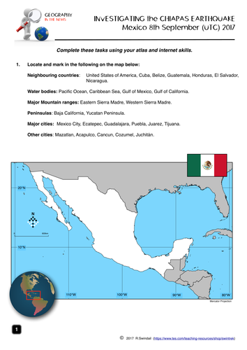
A four page worksheet focusing on the Chiapas earthquake in Mexico on 8th September 2017. Page 1 - simple mapping question to familiarise students with the geographic setting of Mexico Page 2 - students to complete a fact file on Mexico from internet research AND define basic terms associated with earthquakes as well as completing the labelling of an earthquake diagram Page 3 - a map of the earthquake area including tectonic plates - students to answer questions on the earthquake using the map and the USGS website. Page 4 - students answer questions on the impact of the earthquake, the Mexican government's response and a question on past Mexican earthquakes. An answer key is provided for teachers.
Water in the World: the Water Cycle text and worksheets
swintrekswintrek

Water in the World: the Water Cycle text and worksheets

(0)
This is a seven page package that include two pages of text that explain the basic operation of the water cycle and the processes within it. Five pages of activities are included that reinforce a basic understanding of the water cycle and its processes as well as extending your students’ thinking of the water cycle and how people have used and changed it. The package is designed for the Australian Curriculum (Geography Years 7/8) but could be used in other countries where the water cycle may be studied as part of a Geography or Science program in lower high school.
The Water Cycle Word Puzzles
swintrekswintrek

The Water Cycle Word Puzzles

4 Resources
A group of geography word puzzles that are a fun way to learn the terms associated with the water cycle. GeoBingo is a class activity whilst the crossword, word match and word search can be set as homework or class activities.
Weather Instruments Word Puzzle Bundle
swintrekswintrek

Weather Instruments Word Puzzle Bundle

4 Resources
A collection of word puzzles including: 1. Crossword 2. GeoBingo 3. Matchwords 4. Wordsearch All useful for revision, homework, work for fill-in teacher etc.
Hurricane Helene Investigation
swintrekswintrek

Hurricane Helene Investigation

(0)
This is a worksheet (4 pages) that asks your students to investigate Hurricane Helene (September 2024). The first page is a latitude and longitude exercise where the students will be the meteorologist and map the track of the hurricane from its beginning in the waters in the Caribbean Sea to its tracking through the Gulf of Mexico to Florida and states to its north. On the second to fourth pages students will answer general questions on hurricanes and specific set of research questions on Hurricane Helene. An answer key is provided
Hurricane Irma Bundle
swintrekswintrek

Hurricane Irma Bundle

3 Resources
A collection of worksheets that include: 1. Investigating Hurricanes 2. Tracking Hurricane Irma - latitude/longitude exercise 3. Hurricane Irma Worksheet
Geography Crossword Bundle #1
swintrekswintrek

Geography Crossword Bundle #1

4 Resources
A collection of four crossword puzzles on coastal, mountain, riverine and desert landscapes. A great and engaging way to reinforce the basic landforms and processes of these landscapes. Answers are included
Tropical Cyclone Harold Enquiry
swintrekswintrek

Tropical Cyclone Harold Enquiry

(0)
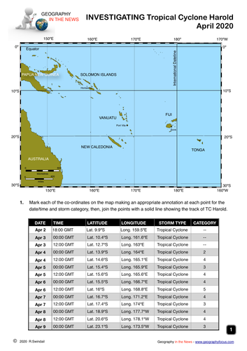
This is a worksheet (4 pages) that will get your students to investigate Tropical Cyclone (April 2020). The first page is a latitude and longitude exercise where the students will be the meteorologist and map the track of the tropical cyclone from its beginning in the waters off Papua New Guinea to its passing the Pacific island of Tonga. On the second to fourth pages students will answer general questions on tropical cyclones and specific set of research questions on TC Harold. An answer key is provided
Eastern Australian Floods: February/March 2022
swintrekswintrek

Eastern Australian Floods: February/March 2022

(0)
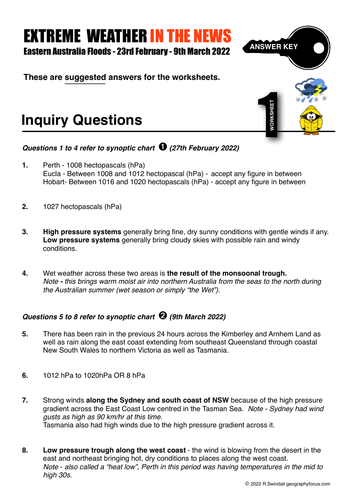
A series of two synoptic charts and four worksheets that introduce students to floods and investigate the floods in Eastern Australia during February/March 2022. Worksheets are: Worksheet 1 - skills questions based on one of the two provided synoptic charts Worksheet 2 - research questions based on a website linked video on floods in general across Australia. Worksheet 3 - research questions based on website link Worksheet 4 - students gather information on the floods from media in three areas (Southeast Queensland, New South Wales north coast rivers and the Sydney Basin/South Coast) Mainly suitable for junior high school but could also be used as a simple introduction to flood hazards in upper high school. An answer sheet is provided.
Topographic Map Skills Exercises
swintrekswintrek

Topographic Map Skills Exercises

(1)
A series of 10 sets of topographic maps and exercises that introduce students to reading of topographic maps. The maps are graded in level of difficulty from the first which practices the students in elementary topographic map skills and progress to more difficult maps and more difficult topographic map skills. The maps are blackline masters and are easily photocopied. Answers are provided for each of the ten sets of exercises. Also available in a bundle that includes these exercises and handouts on all of the basic topographic map skills: https://www.tes.com/teaching-resource/topographic-map-skills-11564811
Australian Maps and map exercises
swintrekswintrek

Australian Maps and map exercises

(0)
Australia in Maps is a series of worksheets based on maps of Australia showing various aspects of its Geography. The maps/worksheets include: States/Territories and their capital cities Water bodies Map 1 Water bodies Map 2 Major Urban Centres Landform Regions Natural Wonders World Heritage Sites Typical summer Weather Map Typical Winter Weather Map 10.Comparing Winter and Summer Weather Maps 11.Climate Regions 1 12.Climate Regions 2 13.Australia’s Neighbours 14.Vegetation Patterns 15.Major Rivers The package is accompanied by answers. The preview shows you the title page, one sample worksheet and one sample answer page. A great way to introduce your students to the geography of Australia!