 Quick View
A level geographical quantitative Skills
<p>This resource is designed for the new AQA A level geography specification, but I assume it is also relevant for other exam boards.</p>
<p>This 44 slide Power Point goes through all the main geographical skills, with worked examples and exam practice opportunities.</p>
<p>Skills included:<br />
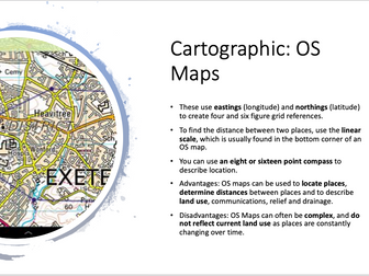
Cartographic - annotation, OS, choropleth, dot, proportional circles, isolines, flow, desire and trip lines.<br />
Graphical - bar, histograms, divided bar, line, pie, scatter, triangular, radial, log-log, semi-log and cumulative scales.<br />
Statistical - mean, median, mode, range, quartiles, interquartile range, standard deviation, significance levels, Spearman’s rank and Chi squared.</p>