 Quick View
Map reading and calculating scales
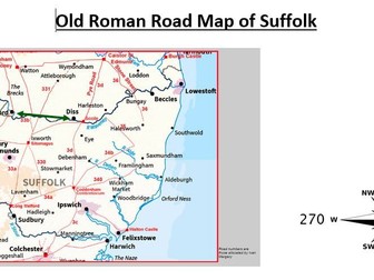
A map of an old Roman road in Suffolk where the learner has to read the scale and use a CM ruler to measure distance then calculate the distance in Km with the scale provided. There are several questions that require the use of measuring. It also requires knowledge of using a compass and there are questions for what compass direction a certain place is. There is some rounding involved with the distance calculation. There is also a question asking the student to guess the distance without measuring. The compass also has bearings on it.