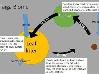
 Quick View
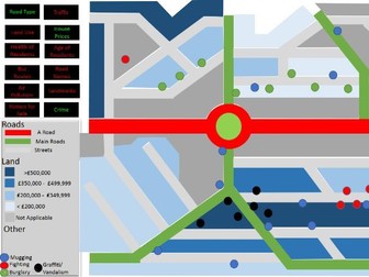
Fully Interactive GIS map simulation on ppt
<p>I devised this resource for a year 7/8 KS3 class. They were learning about GIS from a book, but I felt that some of the concepts were perhaps too abstract. Without any real GIS software I improvised using a PPT to make a computer based lesson.</p>
<p>The PPT contains a map of a town with a number of different data sets such as traffic, land use, crime, bus routes etc etc. The students are told that they are employees of Plankton Estate Agents and our company finds the perfect home for clients using a GIS. Students are then given one of the four worksheets, which contains a client for whom they must find the ideal house and give the reasons for it.</p>
<p>This activity takes about 35 minutes, and can lend itself to discussions about how layers work on a GIS, what other datasets could we add to the map? And so on…</p>
<p>I hope you enjoy. Feel free to modify as you please.</p>