
Something went wrong, please try again later.
attractive idea, thanks
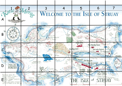
Clear, concise, easy to read, explain and understand. To clarify for a couple of comments, this is a grid and is read from left to right as follows: the perpendicular lines left to right are always read first (and it's always referred as the x-axis, doesn't matter if you label it with numbers, colors, or names, it's STILL the x-axis; the horizontal lines are read second (it's called the y-axis) and ditto for this y-axis, same rules apply. Thus, for THIS particular grid it would be read correctly as B-4 or D-2. If the numbers (labels) ran down the left side and the letters across the top it would be read as 4-D and 2-D. I can't imagine anyone labeling a grid that way but there is no law against it. The same rules apply to a map with latitude and longitude. Read the latitude (left to right) first and the longitude second BUT you'd phrase it with the NUMBER first and the letter second like this: 10°N latitude, 70°W longitude, as opposed to N10° latitude, W70° longitude. I don't know the history of these rules but they seem reasonable and rather self-explanatory. I suspect this is universal because it kinda falls under the universal language of numbers. I doubt it changes for languages that read right to left. I'm just glad someone is still teaching this useful skill to kids!!!
Associated worksheet needs to be amended so that the co-ordinates read correctly. Read the x axis before the y. Otherwise, would have been a good resources.
Surely the number should come before the letter as we read the X axis first.
This is great!!
Report this resourceto let us know if it violates our terms and conditions.
Our customer service team will review your report and will be in touch.
