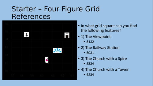
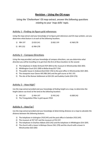
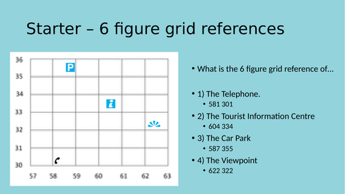
Hero image

RSainty1's Shop

An experienced teacher with experience teaching Key Stage 3, 4, and 5 Geography and Key Stage 5 Psychology. Resources provided will allow for easy and comprehensive teaching of topics from all above age ranges and a variety of exam boards including AQA and OCR Geography and OCR and Eduqas Psychology. All resources provided are tried and trusted by myself and in some instances other teachers in departments I have worked in, so you can be sure to rely on them for your own successful teaching.

An experienced teacher with experience teaching Key Stage 3, 4, and 5 Geography and Key Stage 5 Psychology. Resources provided will allow for easy and comprehensive teaching of topics from all above age ranges and a variety of exam boards including AQA and OCR Geography and OCR and Eduqas Psychology. All resources provided are tried and trusted by myself and in some instances other teachers in departments I have worked in, so you can be sure to rely on them for your own successful teaching.
How to locate six figure grid references
RSainty1RSainty1

How to locate six figure grid references

(0)
This lesson provides an interactive and intuitive introduction to six figure grid references, as part of a typical KS3 topic on map skills. Included in this lesson is a full Presentation, Activity Sheet and handy answers sheet for the teacher providing the lesson.
Map Work Revision Activity and Extension
RSainty1RSainty1

Map Work Revision Activity and Extension

(0)
This combination of worksheets provides a complete overview of a typical KS3 map skills unit, encompassing work on topics such as four and six figure grid references, calculating height on a map and calculating distance on a map, subsequently providing a perfect end of unit revision resource. *For full completion these resources do require access to the Cheltenham 1:50,000 Ordance Survey map extract. A full lesson including Presentation and Starter Activity is also available.
Map Work Revision (Requires Cheltenham 1:50,000 OS extract)
RSainty1RSainty1

Map Work Revision (Requires Cheltenham 1:50,000 OS extract)

(0)
This lesson incorporates all aspects of a typical KS3 map skills topic such as four and six figure grid references, height, and distance making for a perfect end of unit revision lesson. This lesson includes all required resources including a starter activity, main revision task, extension activity and a handy answers sheet for the teacher. *for full completion this lesson will require access to the Cheltenham 1:50,000 Ordnance Survey map extract. The main revision activity sheet and extension sheet are also available at a reduced price.
Height and Relief (map skills)
RSainty1RSainty1

Height and Relief (map skills)

(0)
This resource, suitable for Key Stage Three Geography teaching, covers all important aspects of calculating height and relief on maps including contour lines, spot heights and triangulation pillars among a vast array of activities. *For full completion, this lesson also requires the sheet titled ‘contours’ by Phoebe Murfin, available through TES for free.
Human Impacts on the Arctic (OCR GCSE)
RSainty1RSainty1

Human Impacts on the Arctic (OCR GCSE)

(0)
This pair of resources covers the OCR GCSE requirements for the teaching of human impacts on the Arctic including whaling, over fishing, mining, indigenous people, tourism, and scientific research. Split into two sheets, students should use the information sheets to fill in the gaps on the two gap fill sheets provided to them, however, they must be aware that the information sheets present the information differently to the gap fill sheets.
Svalbard Sustainable Tourism (OCR GCSE)
RSainty1RSainty1

Svalbard Sustainable Tourism (OCR GCSE)

(0)
This pair of resources covers the required content on sustainable tourism in Svalbard, as part of the requirements of the OCR GCSE Geography course. Made up of an A3 worksheet and information sheets students should work in groups to determine how they would solve the different issues facing Svalbard before completing an activity using the information sheets to find out what is actually happening to address the issues in Svalbard.
The Arctic Council and Antarctica Treaty (OCR GCSE)
RSainty1RSainty1

The Arctic Council and Antarctica Treaty (OCR GCSE)

(0)
This lesson encompasses the OCR GCSE Geography teaching requirements of both The Arctic Council and Antarctica Treaty. Including an interactive teacher led worksheet on The arctic Council and a carousel type activity on The Antarctica Treaty, this lesson is designed to last 1 hour. Worksheets for individual activities within the lesson are also available at a slightly reduced price.
Antarctica Treaty (OCR GCSE)
RSainty1RSainty1

Antarctica Treaty (OCR GCSE)

(0)
This resource covers all requirements for the teaching of The Antarctica Treaty within OCR GCSE Geography including basic principles, member countries and aims and rules, all within an engaging carousel type activity for pupils. This lesson also links to another resource on The Arctic Council, the whole lesson is also available.
The Arctic Council (OCR GCSE)
RSainty1RSainty1

The Arctic Council (OCR GCSE)

(0)
This resource links to the OCR GCSE Geography specification regarding required knowledge around The Arctic Council including member countries and aims. Although standalone in this case, the resource does link with a wider lesson on The Arctic Council and The Antarctic Treaty also available.