Complete lesson covering fracking in the UK. Designed for the Edexcel GCSE specification, but could be used with other specifications or lower year groups. Lesson includes:
Do Now - what is fracking?
Video about fracking
Graphs showing the impact of fracking in the US
Map showing where fracking could occur in the UK
AfL - correct the mistakes
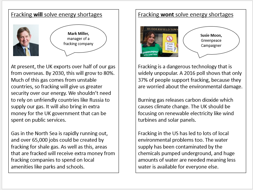
Printable information cards with differing views - students debate
Images illustrating some of the issues with fracking
3 mark exam question and model answer
Complete lesson on different strategies to reduce the development gap. Lesson is set up as a decision making exercise. Lesson includes:
Do Now
Definition of the development gap
Link to videos describing why it’s important to reduce the gap
Decision making activity with printable differentiated worksheets
Teacher-led evaluation of the best strategy
Plenary
Complete lesson covering mitigation of climate change. Lesson includes:
Do Now
Recap on the human causes of climate change
Optional interquartile range practise slide
Video and prompts about the ecological footprint
Mind map about reducing our own ecological footprint
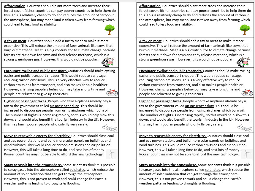
Card sort activity (printable cards) with different mitigation strategies
Evaluation whole class writing
Plenary
Complete lesson covering the geography of the Middle East. Lesson includes:
Do Now - map labelling activity
Think, pair, share with key images from the Middle East
Video and questions
Labelling map task (Atlas required)
Plenary
Complete lesson covering water conflict and water scarcity in the Middle East, with a focus on the Jordan River. Lesson includes:
Do Now - locating the Jordan River
Comparison of precipitation between Jordan and the UK
Keyword match-up activity and extension
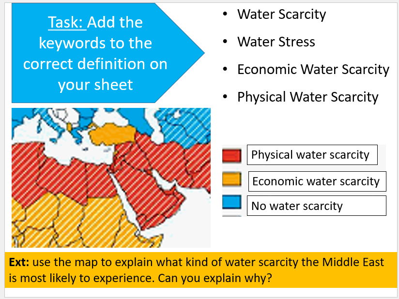
Link to Water Scarcity Atlas for discussion
Video
Annotate and complete the sentences on the map of the Jordan River - printable handout
Plenary
Bonus video and questions
Complete lesson covering some of the reasons why people live on floodplains, with a focus on the Mississippi River. Lesson includes:
Do Now
Drainage basin explanation and keyword match-up
Describe the route of the Mississippi using maps
Comprehension questions covering why people live on the Mississippi floodplain with printable info sheet
Spot the mistakes AfL
Exam question plenary
Complete lesson covering the links between oil and conflict in the Middle East. Focus is on the 1991 Gulf War. Lesson includes:
Do Now
Kuwait location
Video and questions
Worksheet to complete covering causes & effects (lower ability worksheet also available)
Plenary
Complete lesson covering the 2004 Boxing Day tsunami in the Indian Ocean. Lesson includes:
Do Now
Video and questions
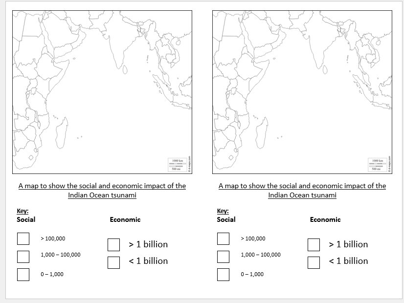
Printable maps and data to create a choropleth map to help students decide which country was worst hit
Decision making activity with 2 options to prevent future tsunamis (printable sheet)
Plenary
Complete lesson covering the reasons why some Middle Eastern borders are straight lines, with a focus on Syria and the Sykes-Picot Agreement. Lesson includes:
Do Now
Prediction activity
Map of the Sykes-Picot agreement
Printable reading sheet (with differentiated one also available) and comprehension activity - can be done independently or as paired work
Writing task
Atlas challenge plenary
Complete lesson covering the role of religion in conflict in the Middle East. Lesson includes:
Do Now
AfL check for understanding
Video about the difference between Shia and Sunni Muslims
Conflict map students annotate using map showing religious divide
Optional additional video & questions
News article and comprehension questions (differentiated lower ability article also available)
Summary plenary
Complete lesson covering solutions to water scarcity and water insecurity. Lesson includes:
Do Now
Video and question about desalination
8 information cards about different strategies, with table to complete
Extension questions
Diamond 9 categorising activity
Plenary
Complete lesson covering the growth of the East Asian Tigers, with a focus on the development of Singapore. Lesson includes:
Do Now
Locate the East Asian Tigers on printable maps
Location of Singapore - correct the mistakes
Printable reading and comprehension questions
Plenary
Complete lesson covering greenfield and brownfield sites. Lesson was designed for the Edexcel A GCSE Geography Spec, but could be used with any GCSE specification or with KS3. Lesson includes:
Do Now
Partner activity to remember the definition of greenfield and brownfield
AfL activity
Definitions
Printable handout covering the pros and cons of each site; students complete a table using the information
Answers
Extended writing activity
2 mark exam question plenary
Complete lesson covering the formation of waterfalls and gorges. Includes:
Do Now - match up keyword activity
Guess the location - widest, tallest and most visited waterfalls using clues
Diagrams and explanation of how a waterfall forms
Main activity - diagram draw and label
Explanation of a gorge
Plenary
Complete lesson covering ethical consumption. Lesson was designed for the Edexcel A-level but would work with other specifications too. Lesson includes:
Do Now
Keyword check
Summary of the world’s ecological footprint
The sustainability quadrant
Info sheets summarising Fairtrade, recycling, Traid, Keep Britain Tidy, ethical shopping and the circular economy - students use this info to annotate their sustainability quadrants
Discussion questions
Complete lesson covering nationalist and independence movements, with a focus on Scottish and Catalan independence. Lesson includes:
Do Now
Maps showing global and regional independence movements
Explanation of the Scottish independence referendum, the key arguments and the outcome
News article on Scottish independence and printable table to complete
Video and questions on Catalan independence
Discussion questions
Continuum activity based on the main challenges to national identity
Lesson covering 4 figure grid references. Includes:
Do Now worksheet
Grid reference explanation and the 2 golden rules
Pacman activity to help students remember
Main activity
Plenary
Complete lesson covering the ways IGOs (intergovernmental organisations) manage the environment through treaties and conventions. Lesson covers 6 key IGO management schemes including the Montreal Protocol on the ozone layer, CITES, the UN Convention on the Law of the Sea, the Helsinki Water Convention, the Antarctic Treaty System and Millennium Ecosystem Assessment. Lesson includes:
Printable table for students to complete through the lesson
Video and article summarising the Montreal Protocol that students use to complete their table
Series of information sheets on the other 5 conventions (with an accompanying news article for each one) that students use to complete the rest of their table
Speed dating sheet for students to question their partners in order to check for understanding
Possible 20 mark exam question and printable planning sheet