I have taught all levels from kindergarten to adult continuing education. I love languages and am constantly working on improving and adding to them. I believe that if students have fun, they will learn faster and remember longer. I try to have students speak in the target language as much as possible during the limited time that they are in class.
I have taught all levels from kindergarten to adult continuing education. I love languages and am constantly working on improving and adding to them. I believe that if students have fun, they will learn faster and remember longer. I try to have students speak in the target language as much as possible during the limited time that they are in class.
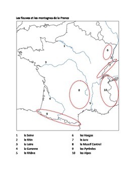
Set of 5 maps for studying the geography of France, each map has several versions. 1 map covers the rivers and mountains; each map has a blank version and a completed version in French, a completed version in English, and a combined French and English version for a quiz. 1 map has the borders of France with 4 versions. 1 map has the cities of France with 5 versions. 1 map has the regions of France [old version with 22 regions] with 4 versions. 1 map has the regions of France [NEW version with 13 regions] with 4 versions. There is 1 other blank map for a total of 22 map pages. 5 pages of brief notes in English about the rivers, mountains, and cities. Consult my geography of France or cities of France power points, Amsco, Wikipedia or any other source for general information about the items covered on the maps.
PowerPoint has 162 slides. Each region has: a map showing where it is located within the country; brief notes in English including capital, area, population, number of provinces and miscellaneous information; a map of the provinces; the coat of arms; the flag; photos of places of interest.
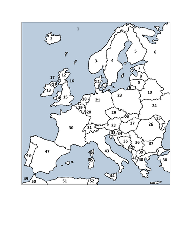
Set of 4 maps of Europe - map of Europe for the countries, map of Europe for the bodies of water, map of Europe for both countries and bodies of water, blank map. 2 page key with capitals included.
Set of 4 maps of Europe - map of Europe for the countries, map of Europe for the bodies of water, map of Europe for both countries and bodies of water, blank map. 2 page key with capitals included.
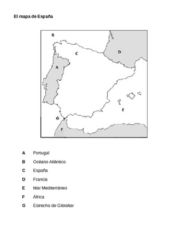
This document has 9 pages: map of Spain with 7 surrounding lands / bodies of water labeled in Spanish; map of Spain with 10 cities labeled; map of Spain with 3 rivers and 3 mountain ranges labeled; map of Spain with regions labeled; the above 4 maps unlabeled; the names for the maps in English.