EVEN MORE printable maps with a simple clue that students use to determine what country is outlined on the sheet.
The first pack of What Country is This? was so popular, that I have made another pack
Again, the clue might be a longitude or latitude, a key city, or a geographical feature.
The task is simple, but the activity is challenging.
Students can also use the shape of the country to help in working out the name of the country.
The worksheets have an answer key at the end. There are 22 maps in all. Some sample pages shown.
Powerpoint slides of maps with a simple clue that can be used as a class activity.
The task is to determine what country is outlined on each slide. First the country outline is shown, then click on to a single clue to help identify the country.
The clue might be a longitude or latitude, a key city, or a geographical feature. Use Google Earth to find the country from the clues provided.
The task is simple, but the activity is challenging.
Once the students identify the country from the shape and/or the clue, click on to see the answer.
There are 22 maps in all.
Slideshow sequence shows the answer at final transition.
(Sample pages only shown here)
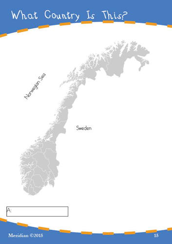
Printable maps with a simple clue that students use to determine what country is outlined on the sheet.
The clue might be a longitude or latitude, a key city, or a geographical feature.
The task is simple, but the activity is challenging.
Students can also use the shape of the country to help in working out the name of the country.
The worksheets have an answer key at the end. There are 22 maps in all. The maps shown here are samples only.
St. Patrick’s Day Google Earth Scavenger Hunt - Digital Learning Resource
Transform your classroom’s St. Patrick’s Day celebration into an engaging virtual journey across Ireland and Irish-American landmarks with our comprehensive Google Earth Scavenger Hunt!
Product Overview
A digital learning resource that combines geography, history, and Irish culture through 33 carefully crafted challenges using Google Earth. Perfect for grades 6-8, this educational pack provides a unique blend of technology and cultural exploration.
Key Features
33 detailed search challenges across multiple categories
Comprehensive teacher’s guide with technical setup instructions
Complete answer key with measurement tolerances
Fascinating “Fun Facts” sections for deeper learning
Bonus challenges for advanced students
Compatible with Google Earth Web, Pro, and Mobile versions
Educational Benefits
Develops digital literacy and geography skills
Enhances research and measurement abilities
Promotes cultural awareness and understanding
Integrates technology with social studies
Supports both independent and collaborative learning
What’s Included
Main scavenger hunt worksheet with 33 challenges
Detailed location-specific fun facts
Technical setup guide for Google Earth
Comprehensive answer key
Network requirement specifications
Perfect For
Middle School Social Studies Classes
Geography Lessons
Cultural Heritage Units
St. Patrick’s Day Activities
Distance Learning Programs
Cross-Curricular STEM Integration
Groundhog Day Virtual Scavenger Hunt: Google Earth Activity Pack
Experience Groundhog Day like never before with this Google Earth scavenger hunt!
Perfect for grades 4-8, this treasure hunt transforms traditional geography lessons into an exciting virtual adventure.
Product Highlights
Go on a virtual tour of 6 famous weather-predicting groundhog locations
Clearly presented worksheets for student engagement
Practice Longitude and Latitude identification
Key Features
10 pages of activities in pdf format
Detailed location-based challenges
Historical imagery exploration tasks
Distance calculation exercises
Clear instructions and guidance
Compatible with Google Earth Web (free version)
Complete Answer Key
Educational Benefits
Develops digital literacy skills
Enhances map reading abilities
Strengthens geographical awareness
Promotes cultural understanding
Builds research and observation skills
Supports STEM learning objectives
Perfect For
Middle school geography classes
Elementary social studies lessons
Distance learning programs
Homeschool curricula
Library educational programs
After-school STEM activities
Package Includes
Student activity worksheets
Technical setup instructions
Answer key for all questions
Why Choose This Resource?
Ready-to-use lesson plans
Engaging virtual field trip experience
No travel costs or logistics
Adaptable for different learning levels
Immediate digital delivery
Valentine’s Day Digital Geography Scavenger Hunt | Google Earth Activity
Transform Valentine’s Day into an engaging global geography lesson with this innovative Google Earth scavenger hunt!
Perfect for middle school students, this ready-to-use digital activity combines cultural exploration, mapping skills, and romantic landmarks worldwide.
Key Features:
✓ 39 carefully curated locations across 6 continents
✓ Complete teacher answer key included
✓ Detailed technical setup guide for Google Earth
✓ Engaging fun facts for each location
✓ Cross-curricular connections with history and cultural studies ✓ Easy-to-follow measurement activities
✓ Compatible with Google Earth Web (free version)
Learning Outcomes:
Master geographical coordinates and navigation
Practice digital mapping skills
Explore world cultures and traditions
Develop measurement and scale understanding
Learn historical significance of global landmarks
Package Includes:
8-page student activity workbook (PDF)
Fun Facts about some of the sites
Comprehensive answer key
Google Earth setup instructions
Perfect for:
Distance learning
Computer lab activities
Homework assignments
Sub plans
Valentine’s Day lessons
Geography units
Exploring Chernobyl Today
Google Maps & Google Earth Activity Pack – A Fascinating Geography Lesson
Take your Middle School or High School students on a virtual journey to one of history’s most significant disaster sites with the “Exploring Chernobyl” Google Maps & Google Earth Activity Pack.
This resource combines real-world geography tools with thought-provoking questions, offering a hands-on learning experience about the Chernobyl nuclear disaster and its global impact.
Students will explore key locations, use distance-measuring tools, and analyze historical imagery to understand the event’s aftermath and the environmental, historical, and social effects of the Chernobyl Exclusion Zone.
Key Features:
Google Maps & Earth Integration: Activities using Google Maps, Google Earth, and Street View to virtually visit Chernobyl and its surroundings.
Historical Analysis: Examine historical imagery and track the development of the Chernobyl sarcophagus over time.
Hands-On Measurements: Use Google tools to measure distances and areas, and explore key sites like the nuclear reactor and abandoned towns.
Critical Thinking Questions: Engage students with challenges such as mapping the Exclusion Zone and analyzing abandoned structures.
Real-World Learning: Perfect for incorporating technology and geography into classroom lessons.
Topics Covered:
The Chernobyl disaster and its global impact
Measuring distances between Chernobyl and major cities (Kyiv, London, Moscow, and more)
The construction and purpose of the Chernobyl sarcophagus
Exploring abandoned sites in the Exclusion Zone, such as Pripyat’s amusement park and ferris wheel
Mapping and understanding restricted zones
Benefits:
Engages students with an interactive and technology-driven approach
Develops practical skills using Google Maps and Earth tools
Enhances understanding of historical and environmental topics
Encourages critical thinking through real-world problem-solving
Perfect for:
Geography Teachers looking for engaging, tech-based activities
History Teachers exploring the global impacts of nuclear disasters
Students developing spatial awareness and analytical skills
Homeschooling Parents seeking innovative educational tools
Download the Activity Pack today and bring history, geography, and technology together for an unforgettable classroom experience!
Google Earth Easter Scavenger Hunt: Interactive Global Geography Adventure for Middle School
Transform your Middle School geography lessons into an exciting digital adventure with this comprehensive Google Earth Easter Scavenger Hunt worksheet pack. Perfect for Grades 6-8, this engaging 15-page resource combines cultural education, digital literacy, and holiday fun into one dynamic learning experience.
Key Features:
Interactive exploration of Easter celebrations worldwide using Google Earth
Cross-curricular integration of geography, cultural studies, and technology skills
Detailed teacher notes and answer key included
Compatible with all versions of Google Earth (Web, Pro Desktop, and Mobile)
Step-by-step technical setup instructions for classroom implementation
Learning Activities Include:
Virtual visits to iconic locations like Vatican City, Jerusalem, and Easter Island
Measurement and calculation exercises using Google Earth tools
Cultural exploration of Easter traditions across different countries
Problem-solving through coordinate-based puzzles
Interactive “Easter egg” discovery challenges
Optional flight simulator routing activity
Technical Skills developed:
Google Earth navigation and tool usage
Distance measurement and geographical calculations
3D terrain visualization
Street View exploration
Digital map reading and interpretation
Educational Benefits:
Enhances digital literacy skills
Develops global cultural awareness
Strengthens problem-solving abilities
Improves spatial awareness and geography skills
Encourages independent learning and exploration
Perfect for:
Middle School geography classes
Cultural studies units
Distance learning activities
Technology integration lessons
Holiday-themed educational activities
Library skill session
Make Easter educational and engaging with this innovative digital scavenger hunt that brings global traditions to life through interactive technology!