I am a Geography specialist who has also been teaching GCSE history for the past few years. I have uploaded some lessons for History and Geography. I hope people find them useful.
I am a Geography specialist who has also been teaching GCSE history for the past few years. I have uploaded some lessons for History and Geography. I hope people find them useful.
AQA GCSE Geography Lesson
This lesson requires the Oxford GCSE Geography for the AQA specification
This lesson includes a number of activities including photograph interpretation, a worksheet to help the students with an evaluation question and further skills such as map and graph interpretation. The actvities are based around the Oxford GCSE Geography for AQA.
Thanks, and hope it helps.
https://www.tes.com/teaching-resources/shop/markthegeographer
AQA GCSE Geography lesson for the new specification Unit 1C: In this lesson we look at what managed retreat is and we also consider an example at Medmerry in West Sussex.
The starter is a a simple true or false quiz that is used for retrieval practice, but is easily edited. We introduce the concept of coastal management schemes first and then we explore the definition of managed retreat with a simple fill in the gap task and the pupils consider when it might be appropriate as a strategy and when not. We introduce Medmerry, the pupils write a description of it’s location before we look at the scheme and why it was needed. The pupils have a worksheet, the questions are answered whilst the pupils watch a video clip on the scheme. They then complete a visual plan map of the scheme to show how the area is flooded. We then consider the benefits and costs of the scheme in a categorising task.
We finish with a 6 mark question on the effectiveness of coastal management schemes. The pupils have some guidance on this if you feel they need it.
In a nutshell lesson includes:
Retrieval practice starter
Short tasks on definition of managed retreat and location of Medmerry.
Worksheet tasks with questions and a plan view map of the scheme.
Information categorising task on costs and benefits of the scheme.
6-mark GCSE-style question with guidance should the pupils need it.
Hope this saves you some valuable planning time.
https://www.tes.com/teaching-resources/shop/markthegeographer
AQA GCSE Geography lesson for the new specification Unit 1C: In this lesson we look at how both meanders and ox-bow lakes are formed by both erosion and deposition.
The starter is a retrieval practice grid filled in for the rivers work so far, but it’s editable.
We then look at a diagram of the Mississippi flood plain and the pupils answer some questions about the archaic meanders that can be seen plotted on the diagram and how they might be formed. We then watch a short video clip on how river meanders get started. We then look at the cross section of a meander and its various features. The pupils get an outline drawing of a meander for them to colour in by numbers to start with, then label the various features on the cross section. The pupils seem to love this colourful neat diagram. The next thing we consider is riffles and pools, after discussing how they are formed the pupils create a diagram in their books for this one. We then watch a video clip on meander formation and there are some colourful diagrams to help teacher explanation. The pupils have a strip to stick in their books, there is a feint outline of the original meander to help them in their drawings. They then explain the process. We finish with a 6-mark question on the formation of ox-bow lakes with some guidance.
In a nutshell lesson includes:
Retrieval practice grid starter.
Question answer session on old Mississippi meanders diagram.
Colour by numbers cross sectional diagram activity.
Diagram activity on the formation of riffles and pools.
Sequential diagram task on ox-bow lake formation.
6-mark GCSE question with guidance.
Hope this saves you some valuable planning time.
https://www.tes.com/teaching-resources/shop/markthegeographer
AQA GCSE Geography lesson for the new specification Unit 1C: In this lesson we look at coastal landforms along the Swanage coastline.
The starter is called “perfect paragraph?” The pupils will see a response to a GCSE-style question and need to spot the errors in the paragraph, we then discuss if anything needs adding to the answer.
We introduce Swanage to the pupils and its location. The pupils will be working on an A3 sheet of paper that will become a revision resource for them in the future. We start by locating Swanage and the pupils describe its location using geographical language. We the look at the discordant and concordant sections of the coastline and the pupils create an annotated map showing the locations of the landforms we will study as well as an explanation of how the geology affects the coastline. We then look at Old Harry Rocks. The pupils will do a field sketch from photograph which they then label to show all the features on the landform. We then look at Lulworth Cove and how it has formed on a concordant coast. The pupils create a 3 stage diagram to show how this formed., they annotate this too/
We finish with a post-it plenary based on a short question regarding the content of the lesson.
In a nutshell lesson includes:
Perfect paragraph? Starter.
A3 poster worksheet with a variety of activities on the landforms around Swanage.
Video clip.
Post-it plenary.
Hope this saves you some valuable planning time.
https://www.tes.com/teaching-resources/shop/markthegeographer
AQA GCSE Geography lesson for the new specification Unit 1C: In this lesson we look at long and cross profiles of a river and how river valleys change shape downstream.
We start with “perfect paragraph”. The pupils read a paragraph describing a drainage basin and they should try to find the errors in the paragraph and what should be added in. We then introduce long profiles, and the pupils will be plotting a long profile of a river on their worksheet. We then look at the upper, middle and lower courses of the river. The pupils shade in these sections on their graph. We complete the worksheet by looking at cross profiles and how river valley shapes change downstream. The pupils create annotated cross sections of the upper, middle and lower courses using the info slides. We finish with a 4 mark GCSE-style question “describe how the shape of a river valley changes downstream”. As always the pupils have some guidance on the question if they need it.
In a nutshell lesson includes:
Perfect paragraph starter.
Long profile plotting exercise.
Cross profile diagram activity.
4-mark GCSE-style question.
Hope this saves you some valuable planning time.
https://www.tes.com/teaching-resources/shop/markthegeographer
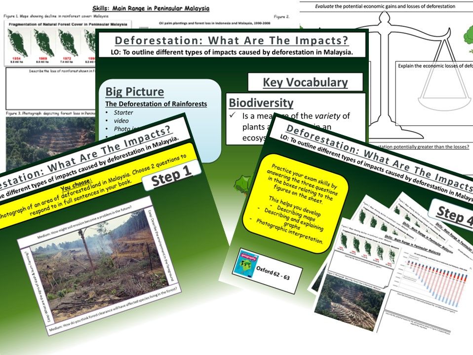
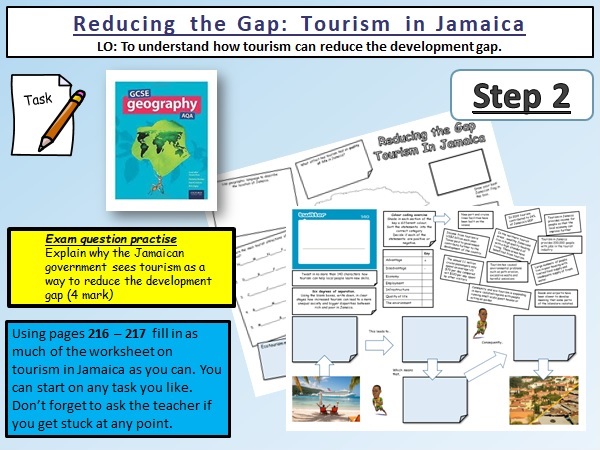
AQA GCSE Geography lesson on reducing the development gap in Malaysia.
****You will need the Oxford GCSE Geography textbook for AQA.
This lesson contains a differentiated a3 worksheet for the pupils to workthrough using the textbook. There is a variety of tasks that the pupils can choose from and some video clips on Jamaica to give the pupils a brief insight into the island.
Included are:-
Starter activity
Video Clips
Differentiated Worksheet.
Hope this helps.
https://www.tes.com/teaching-resources/shop/markthegeographer
AQA GCSE Geography Lesson for the Nigeria: A Newly Emerging Economy unit. The lesson is at lest one hour long, but is easily extended into two lessons. The lesson begins with a photo interpretation starter to introduce the pupils to some of the poverty in Nigeria. We then look at two families in Nigeria, the pupils investigate their living conditions and access to safe water, sanitation and electricity before deciding if the family would benefit from aid and if they represent the majority of Nigerian families. We the look at the benefits of International Aid and the reaons why aid may not be used effectively. We use a GCSE-style question to investigate the latter. Included in the lesson is:
Photo interpretation starter
Families task: comparing living standards (how will aid benefit them?)
Hexagon factor task explaining how aid benefits Nigeria.
GCSE style question on how aid might not be used effectively.
Hope this helps.
https://www.tes.com/teaching-resources/shop/markthegeographer
AQA GCSE Geography lesson for the new specification Unit 1C: In this lesson we look at the formation of headlands and bays through the process of differential erosion.
We start with a simple retrieval practice quiz.
We then introduce the concept of differential erosion and how geology can play big role in the formation of bays and headlands. the pupils are introduced to the features then use a trace outline diagram to alter the coastline to predict what it might look like in the future. The pupils then label the diagrams to show how headlands and bays are formed. We then look at concordant and discordant coastlines. We start by analysing a map of the Swanage coastline, the pupils questioned as to why the coast has different features and shapes. The pupils make a geological map of the area using an outline map, they them annotate where the two types of coastline are.
We finish with a GCSE-style question on the role of geology in the formation of landforms on the coast.
In a nutshell lesson includes:
Retrieval practice starter
Trace it 3-step diagram on the formation of bays and headlands.
A geological outline map of the Dorset coastline activity.
6 mark GCSE-style question with guidance should the pupils need it.
Hope this saves you some valuable planning time.
https://www.tes.com/teaching-resources/shop/markthegeographer
AQA GCSE Geography lesson for the new specification Unit 1C: In this lesson we look at waterfalls and gorges and how they are formed through the processes of erosion.
The starter is a retrieval practice grid filled in for the rivers work so far, but it’s editable.
We then look at how underlying geology plays and important part in the formation of waterfalls, the pupils have some questions to answer and I sometimes get a pupil to teach this bit. We then look at how waterfalls develop, after some teacher exposition the pupils will have an outline diagram of a waterfall with some tasks to complete on the diagram. We then look at the formation of gorges and how they relate to waterfalls. This time the pupils use the diagram on the board to create one themselves. We finish with a sketch from photograph of High Force. After we have introduced the waterfall and given some detail on its formation the pupils will create a field sketch either in a blank box, or using a feint outline, which they can draw over the top of. They then label features etc. We finish with a 6-mark question similar to the 2019 May exam on physical processes and waterfalls/gorges. There is advice and guidance should the pupils need it.
In a nutshell lesson includes:
Retrieval practice grid starter.
Question answer session on how a waterfall starts to form.
Blank outline actvity on the development of waterfalls over time.
Diagram activity on the formation of a gorge.
Worksheet activty on sketching High Force from a photograph.
6-mark GCSE question with guidance.
Hope this saves you some valuable planning time.
https://www.tes.com/teaching-resources/shop/markthegeographer
AQA GCSE Geography lesson for Unit 2C: Water Management. In the lesson we start with a photograph of pollution on the Ganges. The pupils use a command word grid to create a question that they then have to answer. We then look at the issue of pollution and waterborne diseases on water security. The pupils look at the example of The Ganges, they watch two video clips answering questions on the videos as they go. We then look at the impact on food production by looking at USE crop yields. The pupils annotate the graph and answer some questions. We then look at conflict. The pupils use atlases or devices to locate where the examples are on the map they then classify them in accordance to how likely conflict is. We use this information to tackle a GCSE-style question with pupil guidance on how to answer.
In a nutshell lesson includes:
Photo interpretation design your own question starter
Video clips and question sheet on Ganges pollution
Graph interpretation activity on USA crop yields
Water conflict map actvity
GCSE-style question with guidance.
Hope this saves you valuable planning time.
https://www.tes.com/teaching-resources/shop/markthegeographer
AQA GCSE Geography lesson on the Environmental Characteristics of Hot Deserts. This is the second lesson on Hot Deserts for the AQA specification. The lesson includes:
Camel starter activity
Worksheet on plant and animal adaptations
Video clips
4-mark exam question
Plenary memory activity.
The pupils will work there way through these tasks and gain an understanding of plant and animal adaptations.
Hope this helps.
https://www.tes.com/teaching-resources/shop/markthegeographer
AQA GCSE Geography lesson for the new specification Unit 1C: In this lesson we look at depositional features found in the lower course of a river.
The starter is a a countdown retrieval practice quiz with dramatic countdown music!
We start by looking at natural levees and how they are formed. The pupils create a sequence of diagrams to show their formation based on information on the board. They are provided with outline drawings to start with to save time. We then look at the formation of floodplains. The pupils create a diagram based on the instructions on the board without actually seeing the diagram, but there is an example if they are struggling and they are given an outline floodplain to start with. We then look at the formation of estuaries. The pupils annotate a photograph to show the different features of the estuary formed by deposition. We finish on a 4 mark question on the formation of floodplains that was in an exam in 2017. I usually model the answer after the pupils have had a go.
In a nutshell lesson includes:
Retrieval practice grid starter.
Formation of levees sequential diagram.
Formation and features of a floodplain diagram activity with outline.
Photo annotation for estuaries.
4-mark GCSE question with guidance.
Hope this saves you some valuable planning time.
https://www.tes.com/teaching-resources/shop/markthegeographer
GCSE Geography lesson for AQA specification. Unit 2C Water Management.
in this lesson we start by looking at an advert aimed at conserving water in the household. The pupils need to work out what the adverts message is. The second clip shows the adverts true purpose. We then look at what sustainable supplies mean before completing a factor hexagon task on water conservation. We then go on to domestic water supplies and how we can save water at home. the pupils sketch a house in 2 mins, before being given the success criteria afterwards as an example of why checking mark schemes for question types is a good idea. We then annotate around the outside ways we can conserve water at home. The pupils then complete an activity involving an extract which they use to answer questions. We finish with a GCSE-style question with some guidance on how to answer it.
In a nutshell the lesson includes:
Video advert starter
Factor hexagon task on water conservation
Domestic water use task
Extract task with questions on methods of water conservation
GCSE-style question with guidance if the pupils need this.
hope this helps save you some valuable planning time.
https://www.tes.com/teaching-resources/shop/markthegeographer
AQA GCSE Geography lesson for the new specification Unit 1A: In this fourth lesson in the section we look at the effects of climate change around the world.
We start with a quote from Great Thunberg and the pupils discuss whether they think she is right that we should be panicking about climate change and its impacts.
We then look briefly at climate change impacts in the UK where the pupils will annotate a map of the UK using information from a video clip. We then look at the impacts worldwide, the pupils will be given an A3 sheet with a map surrounded by the impacts, they first locate the region the where the impact will be felt, rate the seriousness of the impact and then categorise each one as either social, economic, environmental or political.
Using the information they have now gathered they write a response to Greta Thunberg’s quote using evidence from the lesson. We finish with a post-it plenary using a 2-mark question from the 2019 exam.
In a nutshell lesson includes:
Discussion starter over Greta Thunberg Quote
Annotated diagram of the impacts on the UK
A3 map task on the effects of climate change worldwide
Video clips where appropriate
GCSE-style question plenary
Hope this saves you some valuable planning time.
https://www.tes.com/teaching-resources/shop/markthegeographer
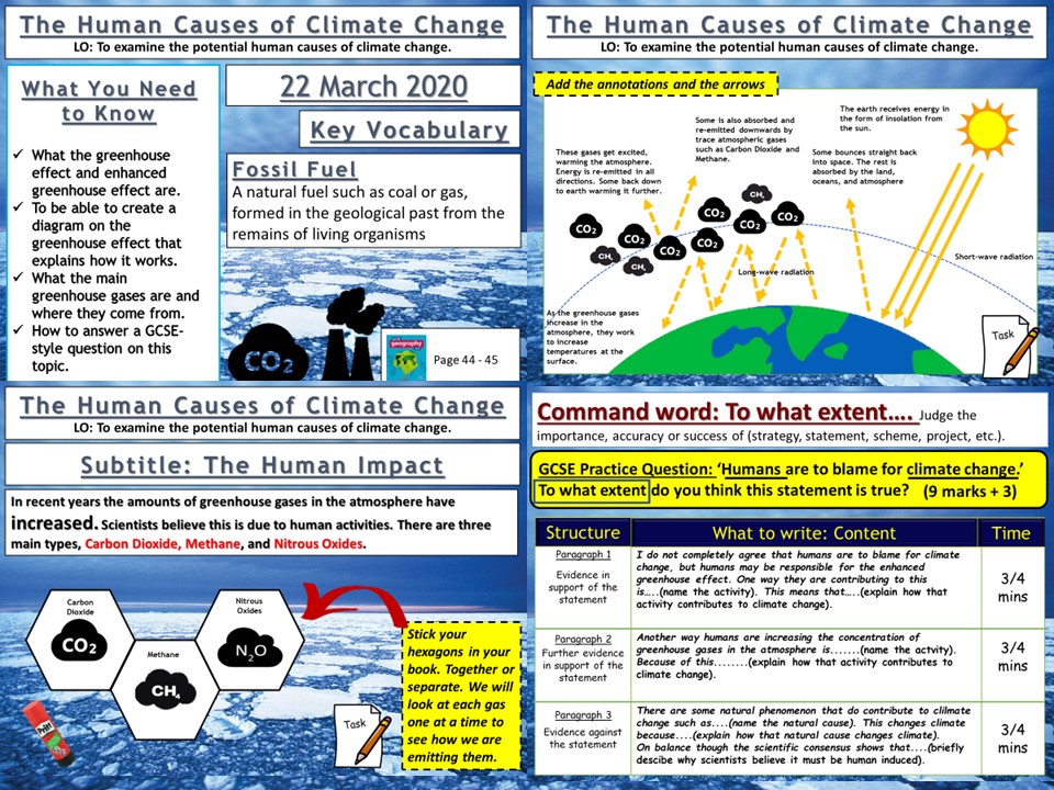
AQA GCSE Geography lesson for the new specification Unit 1A: In this third lesson in the section we look at the possible human causes of climate change.
We start with a simple retrieval practice grid based on previous learning.
We then look at what the scientist think and how a consensus has grown about the impact of anthropogenic influences on the climate and we watch a clip that summarises this. We then create a diagram in our books and the students are guided step by step through the greenhouse effect, creating the diagram as they go. The pupils then watch video clips on the three main greenhouse gases, carbon dioxide, methane and nitrous oxides. The pupils make notes around their hexagons using the video clips to help. We finish by looking at the ‘enhanced greenhouse effect’ and a 9-mark gcse-style question with guidance on how to answer for the pupils.
We finish the lesson with a GCSE-style question post-it plenary.
In a nutshell lesson includes:
Retrieval practice starter
Greenhouse effect diagram.
Hexagon task on the main greenhouse gases
Video clips where appropriate
GCSE-style question.
Hope this saves you some valuable planning time.
https://www.tes.com/teaching-resources/shop/markthegeographer
AQA GCSE Geography lesson for unit 2C: Water Management section. The lesson is approximately one hour long. We start the lesson with a photo mystery around a hydro-electric dam, we use this as a way to start discussing what dams have to do with increasing water supply. The pupils then go on to use a foldable template to look at four different ways that water supply can be increased. The pupils will also create separate sections for examples of dams & reservoirs and also water transfers. We then look at the global pattern of desalination. The pupils will answer questions from the map. We finish with a simple quiz about water surplus (and deficit) using some of the knowledge they should have gained from the last three lessons.
In a nutshell the lesson includes
Starter: Photo mystery used for discussion
Foldables exercise on four methods of increasing water supply
Differentiated map interpretation task
Find the countries with a water surplus quiz.
Hope this saves you some valuable planning time.
https://www.tes.com/teaching-resources/shop/markthegeographer
AQA GCSE Geography lesson for the new specification Unit 1C: In this lesson we look at the processes of longshore drift, deposition and wave refraction.
We start with a retrieval practice grid which can be filled in with your own questions.
We then introduce the concept of longshore drift. We watch a video clip, look at some sequential diagrams, and also consider why some parts of the coastline do not experience longshore drift, yet other parts do. The pupils use this knowledge to complete a worksheet which has several tasks such as explaining, drawing sequential diagrams and annotating. We then move onto deposition and wave refraction. We consider how wave refraction can create areas of erosion and deposition. The pupils create a diagram, which we label and annotate as we go along. There are several extension questions for the pupils to consider too. We finish with a simple post-it plenary on groynes and longshore drift.
In a nutshell lesson includes:
Retrieval practice starter
Worksheet on the process of longshore drift with several activities.
Annotated diagram of wave refraction.
Video clips where appropriate
Post-it plenary.
Hope this saves you some valuable planning time.
https://www.tes.com/teaching-resources/shop/markthegeographer
AQA GCSE Geography lesson for Unit 1A. We start with a simple retrieval quiz, before then looking at the situation of Naples and asking why such a large city has developed near a clear potential threat. We explore this by completing a photo challenge activity with differentiated questions. Pupils will then complete a question wheel about the different reasons why people would choose to live in areas of tectonic hazards. We move on to consider Iceland and the benefits that the country has experienced by living on a plate margin. We then tackle a GCSE-style question with some guidance on structure should the students need it.
In a nutshell the lesson includes:-
Retrieval starter
Photo challenge differentiated activity on Naples and Vesuvius
Question wheel for explaining reasons for living in a hazardous area.
Video on Iceland’s geothermal energy.
Activity exploring benefits for Iceland
GCSE-style question with guidance
I hope this saves you valuable planning time.
https://www.tes.com/teaching-resources/shop/markthegeographer
AQA GCSE Geography Lesson for the new specification Unit1A.
The lesson requires the blue Oxford AQA GCSE textbook for the new specification
We start with a retrieval practice starter with the pupils categorising terms into the correct plate margins. The pupils then, after a brief photo interpretation Q&A activity complete a worksheet that is broken down into monitoring, prediction, protection and planning. The information is all obtained from the Oxford AQA GCSE textbook for the new specification. We then finish the lesson with a GCSE practice question with guidance for the pupils if needed.
Hope this saves you some valuable planning time.
https://www.tes.com/teaching-resources/shop/markthegeographer
AQA GCSE Geography lesson for the new specification Unit 2A: In this lesson we look at how London’s transport strategy and urban greening have improved the quality of life for people living in London.
We start with a retrieval practice grid based on previous learning from this section.
We then look at the green transport strategies London is adopting. Using an information sheet the pupils fill in sections on an A3 worksheet. We next look at Crossrail, the pupils consider the reasons why Crossrail was needed and the arguments for and against Crossrail before answering some questions on how it will improve quality of life in London. We move onto urban greening, using a video clip we consider the benefits of urban greening and then the pupils create a “London Eye” pie chart which they annotate to show how London is a green city and how it is continuing its urban greening.
Once we have completed the diagram we tackle a 6-mark question on how environmental change have led to an increase in the quality of life for people in a HIC city. The pupils do have some help with some points to get them going if they need it.
In a nutshell lesson includes:
Retrieval practice starter
A3 worksheet on transport in London and Crossrail
Two urban greening activities.
Video clips where appropriate
GCSE-style question with guidance
Hope this saves you some valuable planning time.
https://www.tes.com/teaching-resources/shop/markthegeographer