I am a Geography specialist who has also been teaching GCSE history for the past few years. I have uploaded some lessons for History and Geography. I hope people find them useful.
I am a Geography specialist who has also been teaching GCSE history for the past few years. I have uploaded some lessons for History and Geography. I hope people find them useful.
A template for a poster on the literature on which we draw for our KS3 curriculum.
Please feel free to download and edit.
https://www.tes.com/teaching-resources/shop/markthegeographer
A simple coasts retrieval practice starter using a geography field sketch. Please feel free to use and adapt as you see fit.
https://www.tes.com/teaching-resources/shop/markthegeographer
Another retrieval practice slide that is fully editable so please feel free to download and adapt.
https://www.tes.com/teaching-resources/shop/markthegeographer
Another simple retrieval practice starter slide. Can also prompt discussion about how stacks form etc.
https://www.tes.com/teaching-resources/shop/markthegeographer
AQA GCSE Geography lesson for the new specification Unit 1C: In this lesson we look at the formation of headlands and bays through the process of differential erosion.
We start with a simple retrieval practice quiz.
We then introduce the concept of differential erosion and how geology can play big role in the formation of bays and headlands. the pupils are introduced to the features then use a trace outline diagram to alter the coastline to predict what it might look like in the future. The pupils then label the diagrams to show how headlands and bays are formed. We then look at concordant and discordant coastlines. We start by analysing a map of the Swanage coastline, the pupils questioned as to why the coast has different features and shapes. The pupils make a geological map of the area using an outline map, they them annotate where the two types of coastline are.
We finish with a GCSE-style question on the role of geology in the formation of landforms on the coast.
In a nutshell lesson includes:
Retrieval practice starter
Trace it 3-step diagram on the formation of bays and headlands.
A geological outline map of the Dorset coastline activity.
6 mark GCSE-style question with guidance should the pupils need it.
Hope this saves you some valuable planning time.
https://www.tes.com/teaching-resources/shop/markthegeographer
AQA GCSE Geography lesson for the new specification Unit 1C: In this lesson we look at the processes of erosion and transportation (Note we don’t do longshore drift until the next lesson, too much for one lesson!)
We start with a retrieval practice grid from the previous lesson (good for spaced practice).
We then introduce the concept of erosion, we watch a short video clip of he problems at Dawlish several years ago to get the pupils thinking about why erosion is important. We then look at erosion first, the pupils have a worksheet which shows the processes. They need to describe the process, locate the process on the map with an arrow and as a bonus they get to colour the diagram in (They still love doing this in year 11). We briefly look at the four processes of transportation and they do the same thing on the diagram.
Next we explore what factors might affect the rate of these processes occurring. I get the pupils to do a spray diagram or spider diagram. The pupils then use this to answer the question on the worksheet.
In a nutshell lesson includes:
Retrieval practice starter
Worksheet on the processes of erosion and transportation.
Activity on factors influencing these processes
Video clips where appropriate
GCSE-style question with guidance on answering
Hope this saves you some valuable planning time.
https://www.tes.com/teaching-resources/shop/markthegeographer
AQA GCSE Geography lesson for the new specification Unit 1C: In this lesson we look at types of soft engineering and look at an example where they have been applied. We also use the lesson as an opportunity to practice some map skills.
The starter is a simple retrieval practice grid based on the coasts unit of work. We begin by locating Crow Point which is an area in North Devon at risk from coastal erosion where soft engineering strategies have been used to prevent further erosion to the fragile dune system. The pupils will be given a large A3 sheet of paper with an outline map of the area including the dune system. The pupils then use grid references to add labels and features onto their map. Once they have completed this we look at the different types of soft engineering strategies and the advantages and disadvantages. The pupils are given grid references to the location these strategies have been applied. They locate them on their map and write the details in the appropriate box. We do this four all four strategies. This could be done as an info gather, round the room, carousel etc.
We finish with a 4 mark question comparing hard and soft engineering with some guidance on how they can answer this.
In a nutshell lesson includes:
Retrieval practice starter
Map skills practice
Soft engineering information gather task
4-mark GCSE-style question with guidance should the pupils need it.
Hope this saves you some valuable planning time.
https://www.tes.com/teaching-resources/shop/markthegeographer
AQA GCSE Geography lesson for the new specification Unit 1C: In this lesson we look at coastal landforms along the Swanage coastline.
The starter is called “perfect paragraph?” The pupils will see a response to a GCSE-style question and need to spot the errors in the paragraph, we then discuss if anything needs adding to the answer.
We introduce Swanage to the pupils and its location. The pupils will be working on an A3 sheet of paper that will become a revision resource for them in the future. We start by locating Swanage and the pupils describe its location using geographical language. We the look at the discordant and concordant sections of the coastline and the pupils create an annotated map showing the locations of the landforms we will study as well as an explanation of how the geology affects the coastline. We then look at Old Harry Rocks. The pupils will do a field sketch from photograph which they then label to show all the features on the landform. We then look at Lulworth Cove and how it has formed on a concordant coast. The pupils create a 3 stage diagram to show how this formed., they annotate this too/
We finish with a post-it plenary based on a short question regarding the content of the lesson.
In a nutshell lesson includes:
Perfect paragraph? Starter.
A3 poster worksheet with a variety of activities on the landforms around Swanage.
Video clip.
Post-it plenary.
Hope this saves you some valuable planning time.
https://www.tes.com/teaching-resources/shop/markthegeographer
AQA GCSE Geography lesson for the new specification Unit 1C: In this lesson we look at the processes of longshore drift, deposition and wave refraction.
We start with a retrieval practice grid which can be filled in with your own questions.
We then introduce the concept of longshore drift. We watch a video clip, look at some sequential diagrams, and also consider why some parts of the coastline do not experience longshore drift, yet other parts do. The pupils use this knowledge to complete a worksheet which has several tasks such as explaining, drawing sequential diagrams and annotating. We then move onto deposition and wave refraction. We consider how wave refraction can create areas of erosion and deposition. The pupils create a diagram, which we label and annotate as we go along. There are several extension questions for the pupils to consider too. We finish with a simple post-it plenary on groynes and longshore drift.
In a nutshell lesson includes:
Retrieval practice starter
Worksheet on the process of longshore drift with several activities.
Annotated diagram of wave refraction.
Video clips where appropriate
Post-it plenary.
Hope this saves you some valuable planning time.
https://www.tes.com/teaching-resources/shop/markthegeographer
AQA GCSE Geography lesson for the new specification Unit 1C: In this lesson we look at spits and bars together with the processes that lead to their formation.
The starter is a true or false type quiz where the pupils have to find the landforms and processes associated with erosion.
We have a brief reminder of what longshore drift and deposition are. We have a quiz around a photo of Spurn Head and then watch a video clip. The pupils then create annotated diagrams of spits, bars and tombolos. This is usually teacher led in my lessons, but would work as an info hunt/share. We then draw an annotated field sketch from a photograph of Dawlish Warren Spit. The pupils then label the feature of the spit and fill in the blanks on the paragraph.
We finish with a 6 mark GCSE-style question: “Explain how the processes of deposition lead to the formation of distinctive landforms”. The pupils have some guidance in answering this.
In a nutshell lesson includes:
Retrieval practice true or false starter
Video clip
Annotated diagrams on formation of spits, bars and tombolos.
Features of a field sketch from photograph with an example.
6 mark GCSE-style question with guidance should the pupils need it.
Hope this saves you some valuable planning time.
https://www.tes.com/teaching-resources/shop/markthegeographer
AQA GCSE Geography lesson for the new specification Unit 1C: In this lesson we look at what managed retreat is and we also consider an example at Medmerry in West Sussex.
The starter is a a simple true or false quiz that is used for retrieval practice, but is easily edited. We introduce the concept of coastal management schemes first and then we explore the definition of managed retreat with a simple fill in the gap task and the pupils consider when it might be appropriate as a strategy and when not. We introduce Medmerry, the pupils write a description of it’s location before we look at the scheme and why it was needed. The pupils have a worksheet, the questions are answered whilst the pupils watch a video clip on the scheme. They then complete a visual plan map of the scheme to show how the area is flooded. We then consider the benefits and costs of the scheme in a categorising task.
We finish with a 6 mark question on the effectiveness of coastal management schemes. The pupils have some guidance on this if you feel they need it.
In a nutshell lesson includes:
Retrieval practice starter
Short tasks on definition of managed retreat and location of Medmerry.
Worksheet tasks with questions and a plan view map of the scheme.
Information categorising task on costs and benefits of the scheme.
6-mark GCSE-style question with guidance should the pupils need it.
Hope this saves you some valuable planning time.
https://www.tes.com/teaching-resources/shop/markthegeographer
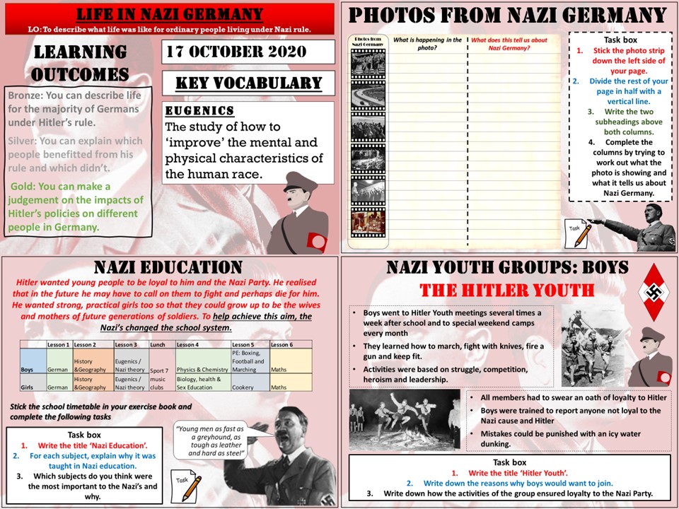
Key Stage 3 lesson for a scheme of work on The Rise of The Dictators. In this lesson we look at what life was like for people living in Nazi Germany. We start with an activity called ‘Photos from Nazi Germany’. The pupils try to work out what is going on in the photos and what this tells us about life in Germany at this time. We then look at life for different types of adults, we use an evidence sheet and the pupils make notes about how those people perhaps benefited, or suffered under Nazi rule. We then look at young people. We start by analyzing a school day fro the German school pupil and why the Nazi’s wanted certain subjects to be taught. We then look at the Hitler Youth and the league of German Maidens and why young people were drawn to these groups and what purpose they served the Nazi’s
I hope this proves useful and saves you some time.
https://www.tes.com/teaching-resources/shop/markthegeographer
AQA GCSE history lesson for The Power & The People thematic unit. In this lesson we look at the causes of the General Strike in 1926.
We start with a retrieval practice grid which has been filled in for the unit so far. We then briefly look at conditions in the mines in the 1920’s and how the mines were privatised after WWI. We then look at the causes of the strike. The pupils complete a strikeometer, a visual scale to show to what extent that cause the miners. We then look at a picture caricature of a mine owner published in a union publication and the pupils answer some questions on the source. We then have a time question and answer session on the lesson content so far and finish with a ‘placard plenary’ where the pupils need to think of the likely slogans the strikers would have placed in their placards.
I hope that this saves you some valuable planning time.
https://www.tes.com/teaching-resources/shop/markthegeographer
Requires the blue AQA GCSE Geography Oxford textbook
AQA GCSE Geography lesson for Unit 1A. In this lesson we compare the Chilean earthquake of 2010 with the Nepalese earthquake of 2015. The lesson includes and photo interpretation starter and video clips where appropriate. the main body of the lesson is used by the pupils to fill out their differentiated worksheets on each earthquake. We then answer a GCSE-style question using a worksheet to help the pupils learn how to structure their answers.
I hope this saves you valuable planning time.
https://www.tes.com/teaching-resources/shop/markthegeographer
AQA GCSE history lesson on how the assassination of Franz Ferdinand start a chain reaction of declarations of war in 1914.
We start with a simple retrieval practice quiz. We then have a brief recap of the murder of Franz Ferdinand in Sarajevo. The pupils have a picture source to look at. We then look at Austria-Hungary’s demands of Serbia. The pupils record the demands and explain how acceptable the demands are to Serbia. We then look at the events of the July Crisis is a sequence of slides. The pupils will record the tension levels in Europe as the events progress by creating a bar chart until a pan-European war is declared. The pupils then revisit the alliance source (a threatening situation) and answer some questions based on the source. We finish with a 16 mark “To what extent” question with some guidance on what the pupils can write about.
Hope you find this useful and it saves you some planning time.
https://www.tes.com/teaching-resources/shop/markthegeographer
AQA GCSE Geography lesson for the latest specification Unit 1B: In this lesson we look at the processes of weathering, erosion, transportation and deposition in glacial environments.
The starter is just a quick photo mystery around glacial deposits.
We then look at the extent of the ice sheet during the Last Glacial Maximum (LGM). We introduce freeze-thaw weathering as the principle type of weathering in glacial environments as the pupils create a sequential diagram. The pupils are provided with a diagram to annotate for the processes of abrasion and plucking. We watch a video on the transportation of material by the glacier and the pupils create a diagram. They then construct a paragraph on transportation by guessing the missing words using the picture prompts. They also construct a paragraph on deposition based on sentence fragments. We finish with a 4 mark GCSE-style exam question with guidance on how to answer it.
Hope this saves you some valuable planning time.
https://www.tes.com/teaching-resources/shop/markthegeographer
AQA GCSE Geography lesson for the new specification Unit 1B: In this lesson we look at what how plants and animals have adapted to the environmental conditions in the rainforest.
The lesson has a retrieval practice starter to begin with. We then look at what biodiversity is and why the rainforests are particularly diverse. We then look at rainforest stratification and plant adaptations. The students have a sheet to complete and some information slides to use to complete the sheet. This could be used as a carousel or group work task. The sheet can even be coloured in! Then the students complete a mix and match up task on the most common types of animal adaptations. The students then complete a rating task with explanation as to how significant are threats to biodiversity in the rainforest. We finish with a GCSE-style practice question with some guidance and structure provided for the students.
Hope this saves you some valuable planning time.
https://www.tes.com/teaching-resources/shop/markthegeographer
AQA GCSE Geography lesson for the new specification Unit 1A: In this lesson we look at monitoring, prediction, planning and protection in regards to tropical storms.
The lesson has a tropical stormed themed retrieval practice starter. We firstly introduce the importance of monitoring to aid prediction with measurements of SST’s. There is a cloze writing exercise on monitoring of hurricanes. A video clip from American tv provides a useful example of how tropical storms are monitored and their paths predicted even on mainstream television. There are some questions for the clip. We then look at protection, specifically storm shelters in Bangladesh, the pupils will have to label the storm shelter and annotate why these features of the storm shelter were needed. We then look at how building in vulnerable areas has made the risks of tropical storms and storm surges more severe. We then look at Bangladesh as a success story of monitoring, predicting, planning and protection, the students have a grid with the actions that have been undertaken by Bangladesh, they have to categorise them accordingly. We finish with a GCSE-style practice question with some guidance and structure provided for the students.
Hope this saves you some valuable planning time.
https://www.tes.com/teaching-resources/shop/markthegeographer
AQA GCSE Geography lesson for the new specification Unit 2B: In this lesson we look at the post-industrial economy and how it has changed the UK economy.
The lesson starts with a quick retrieval practice quiz. We then introduce the idea of a post-industrial economy. The pupils then complete an information gathering exercise where they collect information on three sections of the economy that are behind these changes, development of IT technology, the services industry and finance and research and development. All the information is recorded in a A3 knowledge organiser. We then finish with a GCSE-style practice question with some guidance.
Hope this saves you some valuable planning time.
https://www.tes.com/teaching-resources/shop/markthegeographer
AQA GCSE Geography lessons on the Nigeria: A Newly-emerging Economy section. The lessons feature differentiated tasks, examination style questions and video clips, where appropriate. There is one lesson that needs the AQA textbook, but could easily be adapted to use without it. The lesson titles include:
Nigeria: A Newly-emerging Economy (NEE) Introduction
Exploring Nigeria
Nigeria in the Wider World
Balancing a Changing Industrial Structure
The Impacts of TNC’s
The Impacts of International Aid
Managing Environmental Issues
Quality of Life in Nigeria
Hope the lessons help
https://www.tes.com/teaching-resources/shop/markthegeographer