A recap of previous learning, covering contrasts in development between places, development indicators and graph analysis. Aimed at GCSE, KS4, Years 10 and 11. Contains a starter, several activities and a plenary.
Powerpoint looking at the effect of glaciers on the UK's landscapes
Starter: Ben Nevis as a modern day example of a cold British landscape. Differentiated questions about the formation of u-shaped valleys
Main activities: step-by-step annotated sketch of Malham's limestone landscape. Powerpoint slides explain how the pavement, dry valleys and the Cove were formed
Plenary: looks at how the limestone of Malham became temporarily impervious due to rainwater saturation (and the subsequent short-lived waterfall)
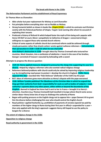
The Reformation Parliament and the establishment of Royal Supremacy
The extent of religious change in the 1530s
Opposition to religious change
Royal authority and government in the 1530s
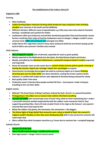
colour coded: green statistics; yellow definitions; blue dates
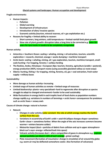
Fragile environments
Human activity and sustainability
Causes of climate change- natural vs human
Recent + prospective impact of climate change in cold environments
Colour coded: green statistics; yellow definitions; blue dates
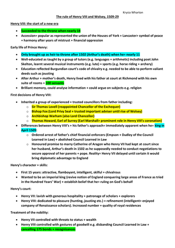
Henry VIII: The start of a new era
Wolsey as Chief Minister- Church and State
England's relations with foreign powers, 1509-1529
Henry's quest for a divorce
colour coded: green statistics; yellow definitions; blue dates
Population ecology + growth dynamics
Population ecology applied to the human population
The balance between population + resources
Carrying capacity + ecological footprint
Positive + negative feedback mechanisms
Challenges driven by human population growth
Malthus and Boserup
Colour coded: green statistics; yellow definitions; blue dates
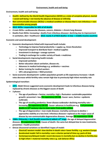
Environment, health and well-being
Economic and social development
Environmental variables + their links to disease
Malaria
Heart disease
The role of the World Health Organisation
The role of other international organisations
Colour coded: green statistics; yellow definitions; blue dates
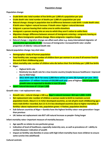
Population change
Models of natural population change- the demographic transition model
Britain’s demographic transition
Demographic transition model applied to countries with contrasting physical + human settings
Population structure
Migration
European migrant crisis 2015
Colour coded: green statistics; yellow definitions; blue dates
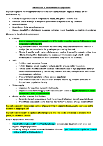
Elements in the physical environment
Role of development processes
Food production and consumption
Polar and tropical monsoon climates
Climate change and agriculture
Soils
Food security
Colour coded: green statistics; yellow definitions; blue dates
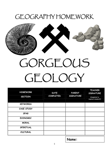
Eight page booklet : define geological keywords; compile a fact file about a geological time period; a SPAG exercise about British geology; a page to research how humans use clay, limestone, marble and sandstone; a moral dilemma: spend money on repairing a historic cathedral or to look after the poor and homeless; complete a database about some of the World's holy rocks and stones; and finally a page to research questions about the UK's geology
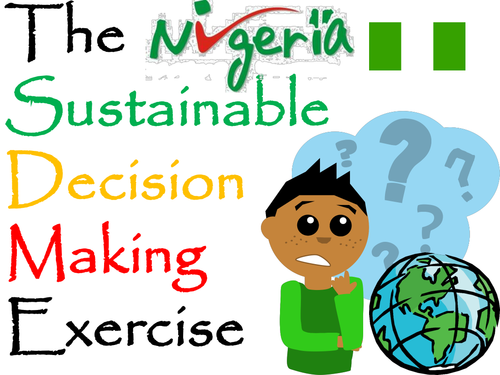
A decision making exercise (set up as a lesson) based around transnational corporations and developing countries.
How can Nigeria meet the United Nations set a Millennium Development Goal of ‘Halve the proportion of people without sustainable access to safe drinking water’?
The Nigerian Government has four options…
-Encourage the use of bottled water in partnership with a transnational company like Nestlé
-Educate Nigerian school pupils to understand the importance of water hygiene
-Form a partnership with a non-government organisation such as Water Aid
-Invest government resources into clean water supplies and sewage treatment works
Includes resources and questions
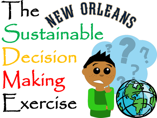
A decision making exercise (set up as a lesson) looking at future options for protecting New Orleans from hurricanes/flooding
New Orleans lies below sea level with a levee system that was designed for hurricanes of no greater intensity than Category 3. The city’s natural defence of the surrounding marshland has been drained, built on or eroded away. A computer model predicted that up to 250,000 people could die in the next Category 5 storm.
The US Government has four options for the 21st Century…
Option 1:
Regenerate the wetlands of the Mississippi Delta
Option 2:
Maintain and heighten the existing levées
Option 3:
Do nothing, let nature take her course
Option 4:
Evacuate the people of New Orleans in hazardous times
England’s relations with foreign powers
Factions at court and the succession
Position of the church by 1547
Assessment of Henry VIII’s reign
Colour coded: green statistics; yellow definitions; blue dates
Powerpoint inspired by the RGS scheme of work "China Today". Whole lesson, includes starter (images of China), mapping activity (China's neighbours), differentiated questions (life in China) and plenary (best and worst about China today).
A 'footsteps' project about China in the 21st Century. Pupils research data and illustrations to complete the booklet. Footsteps follow sections called: Hypothese; Expected Outcomes; Background; Methodology; Data Presentation; Analysis; Conclusion; Evaluation.
Questions for research include:
'China’s growth affects the natural environment because ...'
'In the past, the British Empire affected India because...'
'Most of China’s industries are located in........... because...'
'I think that the winners in Changing China’ are.............. because...'
A decision making exercise which could last a few lessons or be set as a homework project
A property developer is looking to build a five star hotel in San Francisco
Pupils have to decide on the most sustainable county in the Bay Area
Introductory Powerpoint, a project workbook and LOTS of resources are included
The completed project/proposal covers:
Background to tourism in California
The physical hazards threatening San Francisco
Explanation for choosing one of the Bay Area counties
Sustainability (PPP) of the various sites
Reasons for rejecting the others
Consideration of how to make the structure safe from earthquakes
Space for the pupils to be imaginative and design the resort
Revision notes about Henry VII's life and role in the establishment of the Tudor Dynasty
England in 1485
Henry VII and the consolidation of power
Removing threats to Henry's power
Relations with other countries, 1485 to 1509
colour coded: green statistics; yellow definitions; blue dates