One page Case Studies:
TROPICAL STORM (Hurricane Katrina)
DROUGHT (SE England, 2006)
TECTONIC HAZARD (Tohoku Tsunami, Japan)
COASTAL LANDSCAPE (Holderness, Yorkshire)
RIVER LANDSCAPE (Tay Valley, Scotland)
SUSTAINABLE RAINFOREST (B&Q timber policy in the Amazon)
SUSTAINABLE ARCTIC (Svalbard Environmental Protection Act , Norway)
ARCTIC TREATY (The Arctic Council)
CITY IN AN ADVANCED COUNTRY (Hull, Yorkshire)
CITY IN A DEVELOPING COUNTRY (La Paz, Bolivia)
LIDC DEVELOPMENT (Top down and bottom up development, Nigeria)
UK ECONOMIC HUB (The Cambridge Cluster)
UK’S POLITICAL ROLE (Iraq War, 2003)
ETHNIC FOOD IN THE UK (origins of fish & chips and curry)
UK FOOD SECURITY (LOCAL) food banks
UK FOOD SECURITY (PAST) factory farmed chicken
UK FOOD SECURITY (PRESENT) GM crops
Glossary of key words
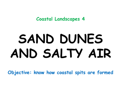
Powerpoint covering spit formation, using Spurn as a Case Study
Starter: simple (revision) sorting activity to sequence weathering, erosion, transportation and deposition
Main activities:YouTube videos and a mystery activity to find out how Spurn Head has formed. Pupils use mystery clues to complete and annotate a base map of southern Holderness and the Humber Estuary. Mini-plenary to recognise associated landforms in aerial photos
Second part uses bespoke, high tech (:D) series of diagrams (an animation if you click your mouse quickly enough!) which show why the point of the spit hooks (the role of secondary winds and wave refraction)
Final part gets pupils to sketch and annotate diagrams of Marram and Glasswort to show how dune and salt marsh plants and habitats are interdependent. Differentiated question... 1-3: Describe how salt marshes and sand dunes are held in position by plants 4-6: Why are salt marsh and sand dune environments natural sea defences? 7-9: What could happen to the Humber Estuary if the vegetation at Spurn Head is not protected?
Plenary: the 250 year cycle of spit formation and destruction at the mouth of the Humber Estuary
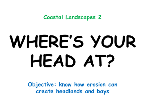
Powerpoint covering headlands and bays along the destructive Holderness coast
Starter: use maps to locate Flamborough Head
Main activities: sketch bird's eye view diagrams showing before and after erosion has affected a discordant coastline. Followed by a differentiated question: 1-3: How do headlands and bays form? 4-6: What role have chalk and boulder clay played in the formation of Flamborough Head?
7-9: What is wave refraction and how has it affected the Flamborough landscape?
Second part gets pupils to annotate a diagram to show the sequence of cave-arch-stack formation using a series of mixed-up pieces of info (so can be done as a card sort or a mystery). Class then feeds back verbally by responding to a series of images and questions
Third part: pupils work together to find advantages and disadvantages of headlands and bays using clues from a large scale OS map
Plenary: pupils recap learning by describing and explaining features seen in a photo of the chalk at Flamborough
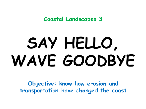
Powerpoint looking at erosion and transportation along Holderness
Starter: the properties of powerful waves, including fetch
Main activities: map work to measure the fetch from Holderness to various coasts of the North Sea. Then radar diagrams are introduced, using a wind rose as an example followed by the pupils constructing a radar to show dominant wave patterns. Then the link between the UK's SW prevailing wind and how it causes NNE dominant waves. Differentiated question... 1-3: What makes a sea wave powerful? 4-6: Explain why North Sea waves can be powerful and damaging
7-9: Refer to data which suggests that Holderness is threatened by powerful waves
Second part gets pupils to draw and label diagrams to compare the features of constructive and destructive waves. They are then asked to assess photos of Holderness to decide which type of wave is affecting that coastline.
Third part looks at the properties of boulder clay and why that soft geology is a problem. Differentiated question: 1-3: Why are the caravan owners worried about the erosion of the cliffs at Hornsea? 4-6: Explain why erosion of the boulder clay is a problem for Holderness
7-9: Explain why the erosion of boulder clay is an economic problem for Holderness businesses
Plenary: pupils are asked to show how they think a typical wave moves, then are shown an animation that describes the circular motion of real wave patterns
Powerpoint introducing Holderness as a Case Study for coastal processes
Starter: use maps to locate Holderness
Main activities: comparison of the properties of chalk (through a memorisation activity and differentiated question) and boulder clay (pupils learn one fact then swap info to answer... What is boulder clay? Where did it come from? How did it get to Yorkshire? What has it got to do with our lesson about coastal landscapes?
Second part gets pupils to draw a sketch map of Holderness then to annotate features that could be lost if erosion continues (using info researched from the internet)
Differentiated question: 1-3: Why are there weaknesses found in chalk? 4-6: Why is Flamborough Head prone to erosion? 7-9: What are the geological reasons for the faults found in the chalk at Flamborough Head?
Plenary shows the wide range of origins for sediment found along Holderness
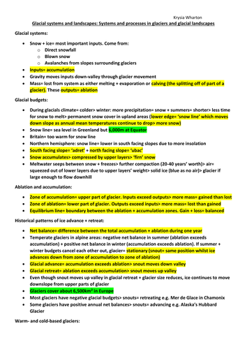
Glacial budgets
Ablation and accumulation
Warm- and cold-based glaciers
Glacial erosion, transportation and deposition
Colour coded: green statistics; yellow definitions; blue dates
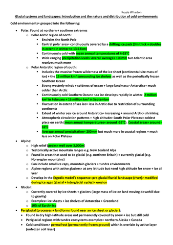
Introduction and the nature and distribution of cold environments
The climate of cold environments
The vegetation of the tundra
Global distribution of past + present cold environments
Colour coded: green statistics; yellow definitions; blue dates
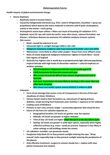
Health impacts of global environmental change
Prospects for global population change
Population revised estimates
Colour coded: green statistics; yellow definitions; blue dates
Powerpoint and worksheets covering constructive plate boundaries, collision zones and volcanic hot spots.
Starter is an odd-one-out game involving keywords and place names linked to tectonics.
Constructive margins focuses on the Galapagos Islands (Nazca and Cocos Plates) where pupils draw a cross section of the boundary then use clues to annotate key features.
Hot spots and magma plumes are then introduced, linking to the African Rift Valley as a land-based plate boundary above a magma plume. A half-time Plenary looks at the importance of the Rift Valley to human evolution.
Then pupils find the answers to questions about the San Andreas Fault through a comprehension exercise and report back to the class.
The final piece of work is an A3 worksheet which combines constructive, destructive and collision boundaries. Pairs of pupils try to remember as much as they can by summarising their recent learning.
The Plenary returns to the Galapagos and the islands' importance in Darwin's Theory of Evolution.
Includes video links and differentiated questions.
Enough for two lessons...
Powerpoint looking at the Upper Stage of the River Tay
Starter: Pupils use maps to discuss the links between the location of Britain’s rivers, patterns of landscape and patterns of precipitation
Main activities: video link introducing the Upper Stage of the Tay
Carousel of activities about erosion types (memorisation), forestry (exam-style questions), features of upland valleys (SPAG), hill sheep (exam-style question), waterfalls (use mystery clues to annotate sequence of diagrams) and HEP (exam-style questions)
Second lesson used for class discussions to recap learning using slides and videos
Class debate on the sustainability of forestry, sheep farming and HEP in the Tay Valley
Differentiated questions about the features found in the Upper Stage
Plenary: simple living graph of the deforestation of Britain over the past 1,000 years
Enough for two lessons
Powerpoint looking at the skill of constructing cross-sections from contour lines
Starter: recap of the formation of v-shaped valleys (including video link)
Main activities: step-by-step slides taking pupils through how to construct a labelled cross-section of the Upper Stage of the River Tay
Analysis of a photo of the Middle Stage of the River Tay to compare human and physical features and then to compare those with a photo of the Upper Stage
Pupils then construct their own cross-section of the Middle Stage
Differentiated questions comparing the cross-sections of the three river stages (the Upper Stage is already completed for them)
Plenary: pupils have to look for clues in photos of a completely different river (the Wisla in Poland) to decide in which stages they were taken
Powerpoint looking at the effect of weathering on the UK's landscapes
Starter: Pupils discuss what might have damaged various materials shown in photos
Main activities: video links, discussion and annotation of diagrams to show sequence of freeze-thaw (frost shatter) and exfoliation (onion skin) weathering
Slides about chemical and biological weathering (for note taking)
Differentiated questions to explain how weathering has affected the chalk landscape of The Seven Sisters (East Sussex, Southern England)
Plenary: video links recapping the four types of weathering covered in the lesson
First Powerpoint in a series looking at the River Tay (Britain's largest river by discharge)
Starter: A comparison of the Tay with the Severn and the Thames and using maps to locate the Tay
Main activities: sketch of a typical river basin, then annotate to show main features (eg tributary, confluence, source, mouth)
Graphing activity to construct the long profile of the Tay (including locating the three stages of the river)
Worksheet and mystery clues comparing the Upper and Lower Stages of the Tay with Bradshaw's River Model
Differentiated questions comparing the Upper and Lower Stages of the Tay Valley
Plenary: video link recapping the long profile of a river
Powerpoint looking at the formation of meanders and oxbow lakes in the Middle Stage of the River Tay
Starter: sketch and match definitions of four types of transportation
Main activities: step-by-step slides taking pupils through the formation of meanders and oxbow lakes. Each pupil is given a fact about the processes involved. Sketches are made of meanders in different stages then pupils use their clues to teach the rest of the class about what is happening so they can label their diagrams. Also includes some photo analysis of river valleys in the real world
Second part gets pupils to draw and label a cross-section of an asymmetrical meander using width, depth and velocity data
Differentiated question: 1-3: Describe how a river channel changes from one side of a meander to the other; 4-6: Explain how a meander can become an oxbow lake over time; 7-9: Explain how meanders and oxbow lakes can be both useful and cause problems for humans
Plenary: pupils recap learning by describing and explaining features seen in a series of satellite photos showing a meander turning into an oxbow over time
Powerpoint and worksheets introducing the concept of distinctive landscapes
Two main activities: assessment of five landscape photos using description (looking for evidence of physical, human and transitory features) followed by bilpolar evaluations of two further landscapes
Differentiated question:
1-3: Describe the main features of the landscape where you live
4-6: Explain the differences between urban and rural landscapes in the UK
7-9: Explain how human and physical features interact to form a named UK landscape
Plenary gets pupils to discuss the most beautiful landscapes they have seen locally, nationally and internationally
Includes video link ('Beautiful Britain')
Case Study: The 2015 Nepal Earthquake
One Powerpoint but with enough detail for two or three lessons
Starter looks at possible advantages and disadvantages of Nepal's geography when it comes to dealing with earthquakes
Main body of the work is divided into:
LOCATION: map skills exercise
CAUSES: plate tectonics, India/Eurasia collision zone; graphing of historic data to look for tectonic patterns; shallow depth earthquakes below the Himalayas
EFFECTS: mapping proportional circles to show aftershocks; choropleth mapping exercise to show deaths by district; discussion of social, economic and environmental effects which are then analysed using an A3 worksheet to link and pairs of effects
SOLUTIONS: analysis of the usefulness of accepting foreign aid; grid worksheet to assess the sustainability of alternative earthquake proofing (car tyres, plastic bottles, straw and bamboo!)
PLENARY: how was Mount Everest affected by the 2015 earthquake?
Includes several resources, differentiated questions and links to internet media
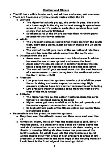
Latitude
Winds
Distance from the sea
Pressure
Altitude
Depressions
Anticyclones
2003 UK heatwave (impacts, management in the future)
Causes of climate change
Arguments for and against climate change
Economic, social, environmental and political impacts of climate change
National and local responses to climate change
Tropical storms
Hurricane Katrina case study
Cyclone Nargis case study
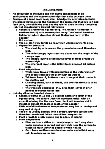
Ecosystems
Tropical rainforests (climate, plant adaptations)
Hot deserts (climate, plant adaptations)
Temperate deciduous forests (climate, plant adaptations)
Temperate deciduous forest case study
Causes of deforestation
Impacts of deforestation
The Amazon case study
Badia Desert, Jordan case study
Sonoran Desert, Arizona case study