Thank you for visiting! Here you will find a selection of printable, interactive worksheets for your classroom: Basic Geography worksheets with simple maps, ESL, Spanish, Bible, Reading Comprehension and more. I hope you find the resources useful! Reviews are welcome and very much appreciated. Thank you so much.
Thank you for visiting! Here you will find a selection of printable, interactive worksheets for your classroom: Basic Geography worksheets with simple maps, ESL, Spanish, Bible, Reading Comprehension and more. I hope you find the resources useful! Reviews are welcome and very much appreciated. Thank you so much.
Introduce your students to Suriname, the smallest country in South America, with this black & white printable handout of two worksheets (plus answer key).
Instant download. Print and go!
Your students will read a brief introduction to Suriname (location, capital, flag, language), write ‘Paramaribo’ next to the star on the map to show the location of the capital, color the map and flag, and use the map and compass to answer 6 questions on page 2. Colored pencils and a pen or pencil are needed for this activity. No other prep needed. Basic Geography worksheet with a simple map to introduce the country of Suriname and practice cardinal and ordinal directions.
For use with Interactive Notebooks: After the worksheet is completed, students can cut out the map and flag and paste into the notebook under the topic of (example) Countries of South American / Sub-Topic: Suriname. Under the map and flag, students can write a summary in their own words about what they know about this country. Collect worksheets of other countries of South America to add to this notebook. All available in this store!
Please note this worksheet prints in black and white. (1) For easy printing, and (2) so students can do all of the the coloring! For more worksheets in black in white (or color) to introduce your learners to countries of South America and around the world, please browse this store!
Thank you so much for using this worksheet in your classroom! I hope you find them useful. Reviews are welcome and very much appreciated.
SPED, resource room teacher, third grade, homework, independent learning.
Introduce your students to the island country of São Tomé and Príncipe in Africa with two worksheets (plus answer key). Instant download. Print and go!
Your students will read a brief introduction to São Tomé and Príncipe (location, capital, flag, language), write ‘São Tomé’ next to the star on the map to show the location of the capital, trace the line of the equator, color the small map, and use the map and compass to answer 8 questions on page 2. Colored pencils and a pen or pencil are needed for this activity. No other prep needed. Basic Geography worksheet with a simple map to introduce São Tomé and Príncipe and practice cardinal and ordinal directions.
For use with Interactive Notebooks: After the worksheets are completed, students can cut out the map and flag and paste into the notebook under the topic of (example) Countries of Africa/Sub-topic: São Tomé and Príncipe. Under the map and flag, your students can write a summary in their own words of what they now know about this country. Collect worksheets for other countries of Africa to add to the notebook! All available in this store!
Thank you so much for using my Geography worksheets in your classroom. I hope you find them useful. Reviews are welcome and very much appreciated.
Rôlas, Caroço, Tinhosas, Portuguese
Introduce your students to Spain with two worksheets (plus answer key). Your students will read a brief introduction to Spain (location, capital, flag, language), write ‘Madrid’ next to the star on the map to show the location of the capital, color the flag and map, and use the map and compass to answer 7 questions on page 2. Colored pencils and a pen or pencil are needed for this activity. No other prep needed. Basic Geography worksheet includes a simple map to introduce Spain and practice cardinal/ordinal directions.
For use with Interactive Notebooks: After completing the worksheets, students can cut out the map and flag and paste into the notebook under the topic of Europe (or Spanish-Speaking Countries), Sub-Topic: Spain. Under the map and flag, students can write a summary in their own words of what they now know about this country. Collect worksheets for other countries of Europe to add to the notebook! Please browse this store for a selection of worksheets for other countries of Europe (and beyond!).
Thank you so much for using my worksheets in your classroom! I hope you find them useful. Reviews are welcome and very much appreciated.
Introduce your students to the SOUTHEAST REGION of the United States with this printable handout of one page (plus answer key). Using the map of the Southeast Region, find the twelve states in the word search puzzle: Virginia, North Carolina, South Carolina, Georgia, Florida, Alabama, Arkansas, Kentucky, Louisiana, Mississippi, Tennessee, West Virginia.
Handouts also available for other regions! Please check out this store for:
-SOUTHWEST REGION MAP AND WORD SEARCH
-NORTHEAST REGION MAP AND WORD SEARCH
-MIDWEST REGION MAP AND WORD SEARCH
-WEST REGION MAP AND WORD SEARCH
Thank you so much for using my Geography worksheets in your classroom!
Introduce your students to the WESTERN REGION of the United States with this printable handout of one page (plus answer key). Using the map of the West Region, find the eleven states in the word search puzzle: Alaska, California, Colorado, Hawaii, Idaho, Montana, Nevada, Oregon, Utah, Washington, Wyoming.
Printable handouts for other regions also available!
SOUTHWEST REGION MAP AND WORD SEARCH
NORTHEAST REGION MAP AND WORD SEARCH
SOUTHEAST REGION MAP AND WORD SEARCH
MIDWEST REGION MAP AND WORD SEARCH
Thank you so much for using my Geography worksheets in your classroom!
Color the map of Europe. Printable handout of 1 page includes a map of Europe to color and learn.
Countries of Europe included: Albania, Andorra, Armenia, Austria, Azerbaijan, Belarus, Belgium, Bosnia and Herzegovina, Bulgaria, Croatia, Cyprus, Czech Republic, Denmark, Estonia, Finland, France, Georgia, Germany, Greece, Hungary, Iceland, Ireland, Italy, Kazakhstan, Kosovo, Latvia, Lithuania, Luxembourg, Macedonia, Malta, Moldova, Monaco, Montenegro, Netherlands, Norway, Poland, Portugal, Romania, Russia, San Marino, Serbia, Slovakia, Slovenia, Spain, Sweden, Switzerland, Turkey, Ukraine, United Kingdom, Vatican City.
Thank you for using my Geography worksheets in your classroom! I hope you find them useful. Reviews are welcome and very much appreciated. Please browse this store for a selection of worksheets to introduce your students to the countries of the world!
Introduce your students to the 13 original colonies with this printable handout (1 worksheet plus answer key). This handout includes the list of 13 colonies and the year each was founded before declaring independence and becoming the United States in 1776. Students will write the name of each colony in the order it was founded, then write the number of each on the map. Includes Virginia, New Hampshire, New York, Massachusetts, Maryland, Connecticut, Rhode Island, Delaware, North Carolina, South Carolina, New Jersey, Pennsylvania, Georgia.
Thank you so much for using my worksheets in your classroom!
Introduce your students to the Midwest region of the United States with this printable handout of one page (plus answer key). Using the map of the Midwest Region, find the twelve states in the word search puzzle: Iowa, Kansas, Missouri, Nebraska, North Dakota, South Dakota, Illinois, Indiana, Michigan, Minnesota, Ohio, Wisconsin.
Handouts for other 4 regions also available! Please check out this store for:
-SOUTHWEST REGION MAP AND WORD SEARCH
-NORTHEAST REGION MAP AND WORD SEARCH
-SOUTHEAST REGION MAP AND WORD SEARCH
-WEST REGION MAP AND WORD SEARCH
Thank you so much for using my Geography worksheets in your classroom!
Introduce your students to the 7 continents with this printable handout of 2 worksheets (plus answer key). Your students will write the name of each continent on the map: Africa, Antarctica, Asia, Europe, North America, Oceania (Australia), and South America, trace the line of the equator, color the small map, and use the map and compass to answer 7 questions. Colored pencils and a pen or pencil are needed for this activity. No other prep needed. Basic geography worksheet with a simple map to introduce the continents and practice cardinal and ordinal directions.
For use with Interactive Notebooks: After the handout is completed, students can cut out the map of the 7 continents and paste into the notebook. Under the map, students can write a summary in their own words of what they now know about the continents. Collect handouts for countries of Africa, Antarctica, Asia, Europe, North America, Oceania/Australia, and South America to add to the notebook! Please browse this store for a selection of printable handouts.
Thank you so much for using my Geography worksheets in your classroom! I hope you find them useful!
Introduce your students to NEW ZEALAND with this printable handout of two worksheets (plus answer key). Your students will read a brief overview of New Zealand (location, capital, flag, language), write ‘Wellington’ next to the star on the map to show the capital, color the small map, and use the map and compass to answer 7 questions. Colored pencils and a pen or pencil are needed for this activity. Basic Geography worksheet with a simple map to introduce New Zealand and practice cardinal and ordinal directions.
For use with Interactive Notebooks: After the handout is completed, students can cut out the map and flag of New Zealand and paste into the notebook. Under the map and flag, students can write a summary in their own words of what they now know about New Zealand. Collect handouts for other countries to add to the notebook. Please check out my store for a selection of worksheets for other countries!
Thank you so much for using my Geography worksheets in your classroom. I hope you find them useful. Reviews are welcome and very much appreciated! Happy Teaching!
Included: Auckland, North Island, South Island, Cook Strait, Stewart Island, Pacific Ocean, Tasman Sea.
Introduce your learners to Panama with two printable worksheets (plus answer key). Your students will read a brief introduction to Panama (location, capital, flag, language), write ‘Panama City’ next to the star on the map to show the location of the capital, color the small flag and map, and use the map and compass to answer 10 questions on page 2. Colored pencils and a pen or pencil are needed for this activity. No other prep needed. Basic Geography worksheet with a simple map to introduce Panama and practice cardinal and ordinal directions.
For use with Interactive Notebooks: After the worksheets are completed, students can cut out the map and flag and paste into the notebook under the topic of (example): Central America or Spanish-Speaking Countries / Sub-Topic: Panama. Under the map and flag, students can write a summary in their own words about what they now know about this country. Collect worksheets for other countries of Central America (or Spanish-Speaking Countries) to add to the notebook! All available in this store! Please browse this store for worksheets for countries of Central America and beyond!
Thank you so much for using my Geography worksheets in your classroom! I hope you find them useful. Reviews are welcome and very much appreciated! Please browse this store for worksheets to introduce your learners to the countries of the world!
Key words: Panama canal, Spanish, cardinal, ordinal directions.
Introduce your learners to Ireland with this printable handout of two worksheets (plus answer key). Your students will read a brief overview of Ireland (location, capital, flag, language), write ‘Dublin’ next to the star on the map to show the location of the capital, color the small map and flag, and use the map and compass to answer 6 multiple-choice questions on page 2. Colored pencils or and a pen or pencil are needed for this activity. No other prep needed. Basic Geography worksheet with a simple map to introduce the country of Ireland.
For use with Interactive Notebooks: After completing the worksheets, students can cut out the map and flag and paste it into the notebook under the topic of Europe / Sub-Topic: Ireland. Under the map, students will write a summary in their own words of what they now know about this country. Collect worksheets for other countries of Europe to add to the notebook! Please browse this store for a selection of worksheets for other countries of Europe (and beyond!).
Thank you so much for using my Geography worksheets in your classroom! I hope you find them useful. Reviews are welcome and very much appreciated.
Introduce your learners to MADAGASCAR in Africa with two worksheets (plus answer key). Your students will read a brief introduction to Madagascar (location, capital, flag, language), write ‘Antananarivo’ next to the star on the map to show the location of the capital, color the small map, and use the map and compass to answer 6 multiple-choice questions on page 2. Colored pencils and a pen or pencil are needed for this activity. No other prep needed. Basic Geography worksheet with a simple map to introduce the country of Madagascar and practice cardinal/ordinal directions.
For use with Interactive Notebooks: After the worksheets are completed, students can cut out the map and flag and paste into the notebook under the topic of Africa / Sub-topic: Madagascar. Under the map and flag, your students can write a summary in their own words of what they now know about this country. Collect worksheets for other countries of Africa to add to the notebook! All available in this store!
Thank you so much for using my Geography worksheets in your classroom! I hope you find them useful. Reviews are welcome and very much appreciated! Please browse this store for worksheets to introduce your learners to all countries of Africa and the world!
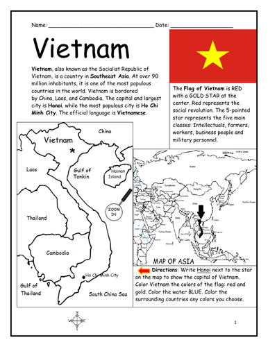
Introduce your students to VIETNAM with this printable handout of two worksheets (plus answer key). Your students will read a brief introduction to Vietnam (location, capital, flag, language), write 'Hanoi’ next to the star on the map to show the capital, color the small map of Vietnam and surrounding, and use the map and compass to answer 7 questions on page 2. Colored pencils and a pen or pencil are needed for this activity. No other prep needed. Basic Geography worksheet with a simple map to introduce Vietnam and practice cardinal and ordinal directions.
For use with Interactive Notebooks: After the worksheets are completed, students can cut out the map and flag and paste into the notebook under the topic of Asia/Sub-Topic: Vietnam. Under the map and flag, your students can write a summary in their own words of what they now know about Vietnam. Collect handouts for other countries of Asia to add to the notebook! All available in this store. Please browse this store for a selection of printable Geography worksheets for countries of Asia (and beyond!).
Thank you for using my Geography worksheets in your classroom! I hope you find them useful. Reviews are welcome and very much appreciated!
Introduce your students to Nicaragua with two printable worksheets (plus answer key). Your students will read a brief introduction to Nicaragua (location, capital, flag, language), write ‘Managua’ next to the star on the map to show the location of the capital, color the small flag and map, and use the map and compass to answer 7 questions on page 2. Colored pencils and a pen or pencil are needed for this activity. No other prep needed. Basic Geography worksheet with a simple map to introduce Nicaragua and practice cardinal and ordinal directions.
For use with Interactive Notebooks: After the worksheets are completed, students can cut out the map and flag and paste into the notebook under the topic of Central America (or Spanish-speaking countries) /Sub-Topic: Nicaragua. Under the map and flag, students can write a summary in their own words of what they now know about this country. Collect worksheets for other countries of Central America to add to the notebook! Please browse this store for a selection of printable handouts for other countries of Central America (and beyond!)
Thank you so much for using my Geography worksheets in your classroom! I hope you find them useful. Reviews are welcome and very much appreciated! Please browse this store for worksheets to introduce your students to the countries of the world!
Introduce your students to Mexico with two printable worksheets (plus answer key). Your students will read a brief introduction to Mexico (location, capital, flag, language), write ‘Mexico City’ next to the star on the map to show the location of the capital, write ‘U.S.’ in each state of the United States, write ‘C.A.’ in each country of Central America, color the map and flag of Mexico, and use the map and compass to answer 7 questions on page 2. Colored pencils and a pen or pencil are needed for this activity. No other prep needed. Basic Geography worksheet with a simple map to introduce Mexico and practice cardinal and ordinal directions.
For use with Interactive Notebooks: After the worksheets are completed, students can cut out the map and flag and paste into the notebook under the topic of (example): Spanish-Speaking Countries / Sub-Topic: Mexico. Under the map, your students can write a summary in their own words of what they now know about this country. Collect worksheets for other Spanish-speaking countries to add to the notebook! All available in this store!
Thank you so much for using my worksheets in your classroom! I hope you find them useful. Reviews are welcome and very much appreciated! Please browse this store for a selection of worksheets to introduce your learners to the countries of the world!
Introduce your students to Uganda with two worksheets (plus answer key). Your students will read a brief introduction to Uganda (location, capital, flag, language), write ‘Kampala’ next to the star on the map to show the location of the capital, color the small map, and use the map and compass to answer 8 questions on page 2. Colored pencils and a pen or pencil are needed for this activity. No other prep needed. Basic Geography worksheet with a simple map to introduce the country of Uganda and practice cardinal/ordinal directions.
For use with Interactive Notebooks: After the worksheets are completed, students can cut out the map and flag and paste into the notebook under the topic of Africa / Sub-topic: Uganda. Under the map and flag, your students can write a summary in their own words of what they now know about this country. Collect worksheets for other countries of Africa to add to the notebook! Please browse this store for a selection of worksheets for other countries of Africa (and beyond!).
Thank you so much for using my Geography worksheets in your classroom! I hope you find them useful. Reviews are welcome and very much appreciated!
Teach your students the countries of Central America with this printable handout (2 worksheets plus answer key). Students will read a brief overview of Central America, write the capital next to the star of each country, write NORTH AMERICA on the upper left side of the map and SOUTH AMERICA on the lower right, color the map, then answer the questions that follow.
Colored pencils and a pen or pencil are needed for this activity. No other prep needed. This printable handout can be used after the handouts of each individual country of Central America are complete (Belize, Guatemala, Honduras, El Salvador, Nicaragua, Costa Rica, Panama) or on its own.
Thank you for using my printable handouts in your classroom! I hope you find them useful. Reviews are welcome and very much appreciated.
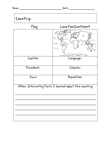
Assign a country or have your students choose a country to learn about on their own. With this printable blank ‘Country Fact Sheet,’ your students will write the name of the assigned country, find the location of that country on the map of the 7 continents, write the country’s capital, language, president, climate, size, population, and list any other interesting facts they learned in their research.
Great for homework and independent study.
Thank you so much for using my printable handouts in your classroom! I hope you find them useful. Reviews are welcome and very much appreciated! Please browse this store for more worksheets to introduce your learners to the countries of the world!
This printable map of Asia includes all 50 countries (list below). 1 printable page. Prints in black and white. Instant download. Print and go! Use as a reference or print to color and learn! and learn the map of Asia with this printable coloring page.
Countries included: Afghanistan, Armenia, Azerbaijan, Bahrain, Bangladesh, Bhutan, Brunei, Cambodia, China, Cyprus, Georgia, India, Indonesia, Iran, Iraq, Israel, Japan, Jordan, Kazakhstan, Kuwait, Kyrgyzstan, Laos, Lebanon, Malaysia, Maldives, Mongolia, Myanmar, Nepal, North Korea, Oman, Pakistan, Palestine, Philippines, Qatar, Russia, Saudi Arabia, Singapore, South Korea, Sri Lanka, Syria, Taiwan, Tajikistan, Thailand, Timor-Leste, Turkey, Turkmenistan, UAE (United Arab Emirates) , Uzbekistan, Vietnam, and Yemen. Also the Arctic Ocean, Pacific Ocean, Indian Ocean and surrounding parts of Europe and Africa.
Thank you for using this printable map of Asia with your learners! I hope you find it useful. Please browse this store for more printable worksheets with simple maps to introduce your students to the countries of the world!