Thank you for visiting! Here you will find a selection of printable, interactive worksheets for your classroom: Basic Geography worksheets with simple maps, ESL, Spanish, Bible, Reading Comprehension and more. I hope you find the resources useful! Reviews are welcome and very much appreciated. Thank you so much.
Thank you for visiting! Here you will find a selection of printable, interactive worksheets for your classroom: Basic Geography worksheets with simple maps, ESL, Spanish, Bible, Reading Comprehension and more. I hope you find the resources useful! Reviews are welcome and very much appreciated. Thank you so much.
Cut out each flag and paste into the map of Central America: Belize, Guatemala, Honduras, El Salvador, Costa Rica, Nicaragua, Panama. This printable handout includes 7 flags and a map to cut out and paste into your interactive notebook.
Introduce your learners to CHINA with this printable handout of two worksheets (plus answer key). Your students will read a brief introduction to China (location, capital, language, flag), write ‘Beijing’ next to the star on the map to show the location of the capital, color the flag and map, and use the map and compass to answer 10 questions on page 2. Colored pencils and a pen or pencil are needed for this activity. No other prep needed. Basic Geography worksheet with a simple map to introduce China and practice cardinal/ordinal directions.
For use with Interactive Notebooks: After your students complete the worksheets, they can cut out the map and paste into the notebook under the topic Asia/Sub-topic: China. Under the map, your students can write a summary in their own words of what they now know about China. Collect worksheets for other countries of Asia to add to the notebook! Please browse this store for a selection of printable Geography worksheets for other countries of Asia (and beyond!).
Thank you so much for using my Geography worksheets in your classroom! I hope you find them useful! Reviews are welcome and very much appreciated.
Notes: China shares land borders with 14 countries: Vietnam, Laos, Myanmar,
India, Bhutan, Nepal, Afghanistan, Pakistan, Tajikistan,
Kyrgyzstan, Kazakhstan, Russia, Mongolia, and North Korea. Pacific Ocean.
Introduce your students to ISRAEL with this printable handout of two worksheets (plus answer key). Your students will read a brief introduction to Israel (location, capital, flag, language), write ‘Jerusalem’ next to the star on the map to show the location of the capital, color the small map, and use the map and compass to answer 9 questions on page 2. Colored pencils and a pen or pencil are needed for this activity. No other prep needed. Basic Geography worksheet with a simple map to introduce Israel and practice cardinal/ordinal directions.
For use with Interactive Notebooks: After the worksheets are completed, students can cut out the map and flag and paste into the notebook under the topic of Asia / Sub-topic: Israel. Under the map and flag, your students can write a summary in their own words of what they now know about Israel. Collect handouts for other countries of Asia to add to the notebook! Please browse this store for a selection of worksheets for all other countries of Asia (and beyond)!
Thank you so much for using my Geography worksheets in your classroom! I hope you find them useful. Reviews are welcome and very much appreciated.
Included: Mediterranean Sea, Red Sea, Dead Sea, Holy Land, Lebanon, Syria, Jordan, Egypt, Saudi Arabia, Tel Aviv, Bethlehem, Nazareth, Palestinian territories West Bank and Gaza, Star of David, Tallit.
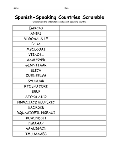
Unscramble each Spanish-speaking country using the list of countries on page 2. Countries included: Argentina, Bolivia, Chile, Colombia, Costa Rica, Cuba, Dominican Republic, Ecuador, El Salvador, Equatorial Guinea, Guatemala, Honduras, Mexico, Nicaragua, Panama, Paraguay, Peru, Puerto Rico, Spain Uruguay, Venezuela. Answer key included.
Thank you so much for using my handouts in your classroom!
Introduce your learners to the continent of ANTARCTICA with this printable worksheet of 2 pages (plus answer key). Your students will read a brief overview of Antarctica (location, climate, etc), color a small map, and answer 7 true/false questions on page 2. Basic Geography worksheet with a simple map to introduce the continent of Antarctica.
Thank you so much for using my Geography worksheets!
Includes: Victoria Land, Wilkes Land, Ice Shelves: Ross, Ronne, and Amery.
Introduce your students to the state of New York with two worksheets (plus answer key). Your students will read a brief introduction to New York (location, capital, state flag, state bird, state flower), write ‘Albany’ next to the star on the map to show the location of the capital, color the small map, state bird and flower, and use the map and compass to answer 8 questions on page 2. Colored pencils and a pen or pencil are needed for this activity. No other prep needed. Basic Geography worksheet with a simple map to introduce New York and practice cardinal and ordinal directions.
For use with Interactive Notebooks: After the worksheets are completed, students can cut out the map, flag, state bird and flower, and paste it into the notebook under the topic of United States/Sub-Topic New York. Under the map, students can write a summary in their own words of what they now know about this state. Collect worksheets for other states of the USA to add to the notebook! Please browse this store for a selection of worksheets for other states of the USA (and beyond!)
Thank you so much for using my worksheets in your classroom! Reviews are welcome and very much appreciated.
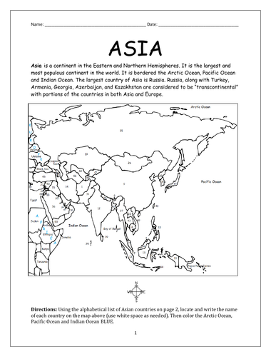
Introduce your students to the continent of Asia with this packet of 7 printable handouts.
Page 1-2: Locate each country of Asia on the map using the alphabetical list of countries on page 2.
Page 3: Word Search: Find countries of Asia A-M. Write the leftover letters in the box below to spell out a fun fact about one of the countries. (The leftover letters will spell out: McDonald’s Israel is a fast food chain in Israel with many kosher locations)
Page 4: Word Search: Find countries of Asia N-Z. Write the leftover letters in the box below to spell out a fun fact about one of the countries. (The leftover letters will spell out: Sri Lanka is called the teardrop of India).
Pages 5-6: List the 50 countries of Asia A-Z (your students will see how many they can remember on their own before referring to the list and map).
Page 7: Languages of Asia. Fill in the blanks.
List of countries included on map of Asia: Afghanistan, Armenia, Azerbaijan, Bahrain, Bangladesh, Bhutan, Brunei, Cambodia, China, Cyprus, Georgia, India, Indonesia, Iran, Iraq, Israel, Japan, Jordan, Kazakhstan, Kuwait, Kyrgyzstan, Laos, Lebanon, Malaysia, Maldives, Mongolia and Myanmar.
Using the map of Malaysia, find and circle the 13 states and 3 territories in the Word Search Puzzle below. States: Perils, Kedah, Kelantan, Penang, Terengganu, Perak, Pahang, Selangor, Negari Sambilan, Malacca, Johor, Sarawak, Sabah. Territories: Kuala Lumpur, Putrajaya, Labuan.
1 printable Word Search Puzzle with map (plus answer key).
Thank you so much for using my printable worksheets in your classroom! I hope you find them useful. Reviews are welcome and very much appreciated.
Introduce your students to COLOMBIA in South America with two printable worksheets (plus answer key). Your students will read a brief introduction to Colombia (location, capital, language, flag), write Bogotá next to the star on the map to show the location of the capital, color the map, and use the map and compass to answer (7) questions on page 2. Colored pencils and a pen or pencil are needed for this activity. No other prep needed. Basic Geography worksheet with a simple map to introduce Colombia and practice cardinal and ordinal directions.
For use with Interactive Notebooks: After the worksheets are completed, students can cut out the map and flag and paste into the notebook under the topic of South America/Sub-topic: Colombia. Under the map, they can write a summary in their own words of what they now know about this country. Collect handouts for other countries of South America to add to the notebook! All available in this store. Please browse this store for a selection of printable handouts for other countries of South America (and beyond!).
Thank you so much for using my Geography worksheets in your classroom! I hope you find them useful. Reviews are welcome and very much appreciated!
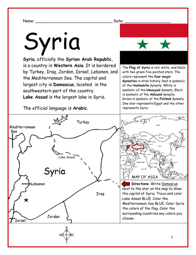
Introduce your students to SYRIA with this printable handout of 2 worksheets (plus answer key). Your students will read a brief introduction to Syria (location, capital, flag, language), write 'Damascus’ next to the star on the map to show the capital, color the small map, and use the map and compass to answer 9 questions on page 2. Colored pencils and a pen or pencil are needed for this activity. No other prep needed. Basic Geography worksheet with a simple map to introduce Syria and practice cardinal and ordinal directions.
For use with Interactive Notebooks: After the worksheets are completed, students can cut out the map and flag of Syria and paste into the notebook under the topic of Asia/Sub-Topic: Syria. Under the map and flag, your students can write a summary in their own words of what they now know about this country. Collect handouts for other countries of Asia to add to the notebook! All available in this store! Please browse this store for a selection of printable handouts for other countries of Asia (and beyond!).
Thank you so much for using my Geography worksheets in your classroom! I hope you find them useful. Reviews are welcome and very much appreciated!
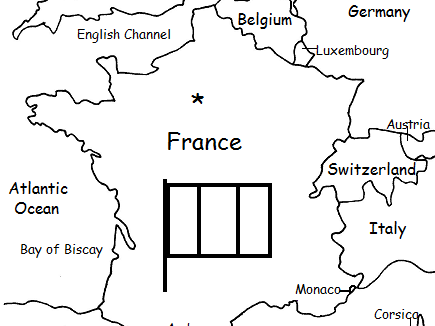
Introduce your students to France with this printable handout of two worksheets (plus answer key). Your students will read a brief introduction to France (location, capital, flag, language), write ‘Paris’ next to the star on the map to show the location of the capital, color the small map and flag, and use the map and compass to answer 7 questions on page 2. Colored pencils and a pen or pencil are needed for this activity. No other prep needed. Basic geography worksheet includes a simple map to introduce France and practice cardinal/ordinal directions.
For use with Interactive Notebooks: After completing the worksheets, students can cut out the map and flag and paste it into the notebook under the topic of Europe/Sub-Topic: France. Under the map and flag, students can write a summary in their own words of what they now know about France. Collect worksheets for other countries of Europe to add to the notebook! Please browse this store for a selection of worksheets for other countries of Europe (and beyond!).
Thank you so much for using my Geography worksheets in your classroom! Reviews are welcome and very much appreciated.
Included on map: Belgium, Luxembourg, Germany, Switzerland, Italy, Monaco, Andorra, Spain, Corsica, United Kingdom, Netherlands, Austria, North Sea, English Channel, Bay of Biscay, Mediterranean Sea, Atlantic Ocean.
Find the 13 Original Colonies in the Word Search Puzzle. They can be found forward or backward. Then write the remaining letters below to spell out a fact about the original colonists (1 printable handout plus answer key).
13 colonies: Connecticut, Delaware, Georgia, Maryland, Massachusetts, New Hampshire, New Jersey, New York, North Carolina, Pennsylvania, Rhode Island, South Carolina, Virginia.
Remaining letters will spell: The first colonists settled near James River in Jamestown, Virginia.
Thank you so much for using my printable handouts in your classroom!
Introduce your learners to the continent of Europe with this packet of 7 printable worksheets! Instant download. Print and go!
Page 1-2: Your students will locate each country of Europe on the map using the alphabetical list of countries on page 2 (list of included countries below).
Page 3: Word Search: Find European countries A-L. Write the leftover letters in the box below to spell out a fun fact about one of the countries. (The leftover letters will spell out: At over seven thousand feet deep the Krubera cave in Georgia is the deepest cave in the entire world).
Page 4: Word Search: Find European countries M-Z. Write the leftover letters in the box below to spell out a fun fact about one of the countries. (The leftover letters will spell out: The smallest country in the world is The Vatican City and located in Rome Italy).
Pages 5-6: List the 51 countries of Europe A-Z (your students will see how many they can remember on their own before referring to the list and map).
Page 7: Languages of Europe. Fill in the blanks.
List of countries included on map: Albania, Andorra, Armenia, Austria, Azerbaijan, Belarus, Belgium, Bosnia and Herzegovina, Bulgaria, Croatia, Cyprus, Czech Republic, Denmark, Estonia, Finland, France, Georgia, Germany, Greece, Hungary, Iceland, Ireland, Italy, Kazakhstan, Kosovo, Latvia, Lithuania, Luxembourg, Macedonia, Malta, Moldova, Monaco, Montenegro, Netherlands, Norway, Poland, Portugal, Romania, Russia, San Marino, Serbia, Slovakia, Slovenia, Spain, Sweden, Switzerland, Turkey, Ukraine, United Kingdom, Vatican City.
Printable handouts are also available for individual countries of Europe! Please browse this store for a selection of introductory worksheets with simple maps for each country of Europe.
Thank you so much for using my Geography worksheets in your classroom! I hope you find them useful. Reviews are welcome and very much appreciated. Please follow this store for more worksheets.
Happy Teaching!
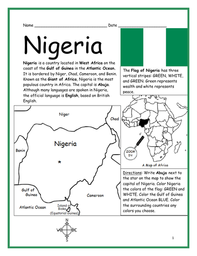
Introduce your students to Nigeria with this printable handout of two worksheets (plus answer key). Your students will read a brief introduction to Nigeria (location, capital, flag, language), write ‘Abuja’ next to the star on the map to show the capital, color the small map, and use the map and compass to answer 8 questions on page 2. Colored pencils and a pen or pencil are needed for this activity. Basic Geography worksheet includes a simple map to introduce the country of Nigeria and practice cardinal/ordinal directions.
For use with Interactive Notebooks: After the worksheets are completed, students can cut out the map and flag and paste into the notebook under the topic of Africa / Sub-topic: Nigeria. Under the map and flag, your students can write a summary in their own words of what they now know about this country. Collect worksheets for other countries of Africa to add to the notebook! Please see this store for a selection of printable worksheets for other countries of Africa (and beyond!).
Thank you so much for using my Geography worksheets in your classroom! I hope you find them useful. Reviews are welcome and very much appreciated!
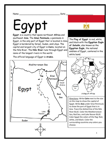
Introduce your students to Egypt with two worksheets (plus answer key). Your students will read a brief introduction to Egypt (location, capital, flag, language), write ‘Cairo’ next to the star on the map to show the location of the capital, write ‘Asia’ under the Sinai Peninsula to show the part of Egypt that is located in Asia, trace the dotted line of the Nile River, color the small map, and use the map and compass to answer 9 questions on page 2. Colored pencils and a pen or pencil are needed for this activity. No other prep needed. Basic Geography worksheet with a simple map to introduce the country of Egypt and practice cardinal/ordinal directions.
For use with Interactive Notebooks: After the worksheets are completed, students can cut out the map and flag and paste into the notebook under the topic of Africa, Asia, or Middle East / Sub-topic: Egypt. Under the map and flag, your students can write a summary in their own words of what they now know about this country. Collect worksheets for other countries of Africa, Asia or the Middle East to add to the notebook! Please browse this store for a selection of worksheets for countries of Africa or Asia (and beyond!)
Thank you so much for using my Geography worksheets in your classroom! I hope you find them useful. Reviews are welcome and very much appreciated.
Introduce your learners to the country of Pakistan with this printable handout of two worksheets (plus answer key). Simple map activity and reading comprehension questions. Print and go! No prep needed.
Your students will read a brief introduction to Pakistan (location, capital, language, flag, motto), write ‘Islamabad’ next to the star on the map to show the location of the capital, color the small map, and use the map and compass to answer 7 questions on page 2. Colored pencils and a pen or pencil are needed for this activity. No other prep needed. Basic Geography worksheet with a simple map to introduce Pakistan and practice cardinal/ordinal directions.
For use with Interactive Notebooks: After the worksheets are completed, students can cut out the map and flag and paste into the notebook under the topic of (example) Countries of Asia /Sub-topic: Pakistan. Under the map, students can write a summary in their own words of what they now know about this country. Collect worksheets for other countries of Asia to add to the notebook! All available in this store.
Thank you so much for using my Geography worksheets in your classroom! I hope you find them useful. Reviews are welcome and very much appreciated. Please browse this store for more printable handouts with simple maps to introduce your learners to the countries of the world!
sped, homeschool, resource room teacher, third grade, elementary school, primary
Do your students know all 51 countries of Europe? With this printable activity, your students will fill in the blank letters for each country of Europe! One printable worksheet plus answer key that includes the list of countries in alphabetical order. Print and go!
List of countries included: Albania, Andorra, Armenia, Austria, Azerbaijan, Belarus, Belgium, Bosnia and Herzegovina, Bulgaria, Croatia, Cyprus, Czech Republic, Denmark, Estonia, Finland, France, Georgia, Germany, Greece, Hungary, Iceland, Ireland, Italy, Kazakhstan, Kosovo, Latvia, Lithuania, Luxembourg, Macedonia, Malta, Moldova, Monaco, Montenegro, Netherlands, Norway, Poland, Portugal, Romania, Russia, San Marino, Serbia, Slovakia, Slovenia, Spain, Sweden, Switzerland, Turkey, Ukraine, United Kingdom, Vatican City.
Introduce your learners to each country of Europe one country at a time with a printable worksheet for each country. Each country includes a simple map activity and reading comprehension activities. All available in this store!
Thank you so much for using my worksheets in your classroom. I hope you find them useful. Reviews are welcome and very much appreciated! Please browse this store for more printable worksheets to introduce your learners to the countries of the world!
Introduce your learners to the U.S. state of HAWAII with this printable handout of two worksheets (plus answer key). Your students will read a brief introduction to Hawaii (location, capital, flag, language, main islands, state bird, state flower), write ‘Honolulu’ next to the star on the map on the island of Oahu to show the capital, color the small map, and answer 6 questions on page 2. Colored pencils and a pen or pencil are needed for this activity. No other prep needed. Basic Geography worksheet with a simple map to introduce the state of Hawaii.
For use with Interactive Notebooks: After the worksheets are completed, students can cut out the map, flag, state bird and flower of Hawaii and paste into the notebook under the topic of United States / Sub-Topic: Hawaii. Under the map, students can write a summary in their own words of what they now know about this state. Collect worksheets for all U.S. states to add to notebook! Please browse this store for a selection of worksheets for other states of the USA (and beyond!).
Thank you so much for using my Geography worksheets in your classroom! I hope you find them useful. Reviews are welcome and very much appreciated.
Islands included on map: Hawaii, Niihau, Kauai, Oahu, Molakai, Lanai, Kahoolawe, Maui. Pacific Ocean.
Introduce your learners to Afghanistan with two worksheets (plus answer key). Your students will read a brief introduction to Afghanistan (location, capital, language, flag), write ‘Kabul’ next to the star on the map to show the location of the capital, color the small map, and use the map and compass to answer questions on page 2. Colored pencils and a pen or pencil are needed for this activity. No other prep needed. Basic Geography worksheet with a simple map to introduce Afghanistan and practice cardinal/ordinal directions.
For use with Interactive Notebooks: After completing the worksheet, students can cut out the map and paste into the notebook under the topic Asia/Sub-topic: Afghanistan. Under the map, students can write a summary in their own words of what they now know about this country. Collect worksheets for other countries of Asia to add to the notebook! Please browse this store for a selection of printable worksheets for other countries of Asia (and beyond!)
Thank you so much for using my Geography worksheets. I hope you find them useful! Reviews are welcome and very much appreciated.
Introduce your learners to the island country of JAMAICA with this printable handout of 2 worksheets (plus answer key). Your students will read a brief introduction to Jamaica (location, capital, flag), write ‘Kingston’ next to the star on the map to show the location of the capital, color the maps, and use the maps and compass to answer 10 true/false questions on page 2. Colored pencils and a pen or pencil are needed for this activity. No other prep needed. Basic Geography worksheet with simple maps to introduce the country of Jamaica and practice cardinal and ordinal directions.
For use with Interactive Notebooks: After the worksheets are completed, students can cut out the map and flag and paste into the notebook (under the topic of the Caribbean or West Indies or Greater Antilles / Sub-topic: Jamaica). Under the map, your students can write a summary in their own words of what they now know about this country. Collect worksheets of other countries to add to the notebook! Please browse this store for a selection of worksheets for other countries of the Caribbean (and beyond!).
Thank you so much for using my Geography worksheets in your classroom! Reviews are welcome and very much appreciated.
Caribbean Sea, Cuba, Hispaniola, Dominican Republic, Haiti, Cayman Islands, Montego Bay, Negril, Port Antonio, Blue Mountain, Blue Mountain Peak.