Thank you for visiting! Here you will find a selection of printable, interactive worksheets for your classroom: Basic Geography worksheets with simple maps, ESL, Spanish, Bible, Reading Comprehension and more. I hope you find the resources useful! Reviews are welcome and very much appreciated. Thank you so much.
Thank you for visiting! Here you will find a selection of printable, interactive worksheets for your classroom: Basic Geography worksheets with simple maps, ESL, Spanish, Bible, Reading Comprehension and more. I hope you find the resources useful! Reviews are welcome and very much appreciated. Thank you so much.
Introduce your learners to the Philippines in Southeast Asia with this printable handout of two worksheets (plus answer key). Your students will read a brief introducction to the Philippines (location, capital, language, flag), write ‘Manila’ next to the star on the map to show the capital, trace the lines to separate the islands into three regions: Luzon, Visayas and Mindanao, color the small map, and use the map and compass to answer 9 questions on page 2. Colored pencils and a pen or pencil are needed for this activity. No other prep needed. Basic Geography worksheet with a simple map of Philippines and Southeast Asia to introduce the Philippines and practice cardinal and ordinal directions.
For use with Interactive Notebooks: After the worksheets are completed, students can cut out the map and flag paste into the notebook under the topic Asia/Sub-topic: Philippines. Under the map, your students can write a summary in their own words of what they now know about this country. Collect worksheets for other countries of Asia to add to the notebook! Please browse this store for a selection of printable worksheets for other countries of Asia (and beyond!).
Thank you so much for using my Geography worksheets in your classroom! I hope you find them useful… Reviews are welcome and very much appreciated! Please browse this store for worksheets to introduce your students to the countries of the world.
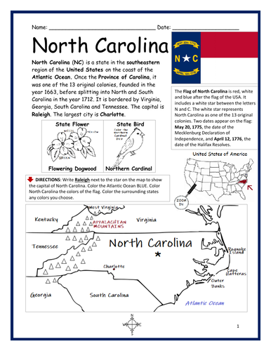
Introduce your learners to the state of North Carolina with this printable handout of two worksheets (plus answer key). Your students will read a brief overview of North Carolina (location, capital, flag, state bird, state flower), write ‘Raleigh’ next to the star on the map to show the location of the capital, color the small map, state bird and state flower, and use the map and compass to answer 10 true/false questions on page 2. Colored pencils and a pen or pencil are needed for this activity. No other prep needed. Basic Geography worksheet with a simple map to introduce the state of North Carolina and practice cardinal and ordinal directions.
For use with Interactive Notebooks: After the worksheets are completed, students can cut out the map, flag, state bird and state flower of North Carolina and paste into the notebook under the topic of United States/Sub-Topic: North Carolina. Under the map, students can write a summary in their own words of what they now know about this state. Collect worksheets for other states of the US to add to the notebook! Please browse this store for a selection of worksheets for other states of the USA (and beyond!).
Thank you so much for using my worksheets in your classroom! Reviews are welcome and very much appreciated!
Included: Province of Carolina, Virginia, Georgia, South Carolina, Tennessee, Charlotte, Appalachian Mountains, Atlantic Ocean.
Introduce your students to Colombia in South America with this black & white printable handout of two worksheets (plus answer key). Your students will read a brief introduction to Colombia (location, capital, flag, language), write Bogotá next to the star on the map to show the location of the capital, color the map and flag, and use the map and compass to answer 7 questions on page 2. Colored pencils and a pen or pencil are needed for this activity. No other prep needed. Basic Geography worksheet with a simple map to introduce the country of Colombia and practice cardinal and ordinal directions.
This worksheet prints in black and white - (1) For easy printing, and (2) so students can be in charge of all the coloring!
Thank you so much for using my Geography worksheets in your classroom! Reviews are welcome and very much appreciated!
Using the map, find the 17 regions of Spain in the Word Search Puzzle. 1 printable word search puzzle with map (plus answer key).
Regions of Spain to find in Word Search Puzzle:
Andalucía
Aragon
Asturias
Balearic Islands
Basque Country
Canary Islands
Cantabria
Castilla-La Mancha
Castilla Y Leon
Catalonia
Extremadura
Galicia
La Rioja
Madrid
Murcia
Navarra
Valencia
Thank you so much for using my worksheets in your classroom! I hope you find them useful. Reviews are welcome and very much appreciated! Please browse this store for a selection of Geography worksheets, word search puzzles and more!
Introduce your learners to India with this printable handout of two worksheets (plus answer key). Your students will read a brief introduction to India (location, capital, flag, language), write ‘New Delhi’ next to the star on the map to show the location of the capital, color the small map and flag, and use the map and compass to answer 8 questions on page 2. Colored pencils and a pen or pencil are needed for this activity. No other prep needed. Basic Geography worksheet with a simple map to introduce India and practice cardinal and ordinal directions.
For use with INTERACTIVE NOTEBOOKS: After the worksheets are completed, students can cut out the map and flag and paste into the notebook under the topic of Asia/subtopic: India. Under the map and flag, students can write a summary in their own words of what they now know about this country. Collect worksheets for other countries of Asia to add to the notebook. Please browse this store for a selection of worksheets for other countries of Asia (and beyond!).
Thank you so much for using my Geography worksheets in your classroom! I hope you find them useful. Reviews are welcome and very much appreciated!
India and surrounding: Indian Ocean, Arabian Sea, Bay of Bengal, Pakistan, Afghanistan, China, Nepal, Bhutan, Bangladesh, Myanmar. Official language is Hindi.
Introduce your learners to HAITI with this printable handout of 2 worksheets (plus answer key). Your students will read a brief introduction to Haiti (location, capital, flag, islands); write ‘Port-au-Prince’ next to the star on the map to show the location of the capital, color the flag and map, and use the map and compass to answer 8 questions on page 2. Colored pencils and a pen or pencil are needed for this activity. No other prep needed. Basic Geography worksheet with a simple map to introduce Haiti and practice cardinal and ordinal directions.
For use with Interactive Notebooks: After the worksheets are completed, students can cut out the map and flag and paste into the notebook under the topic of Caribbean Islands / Sub-topic: Haiti. Under the map and flag, your students can write a summary in their own words of what they now know about Haiti. Collect worksheets for other countries to add to the notebook! Please browse this store for a selection of worksheets for other countries of the Caribbean (and beyond!).
Haiti and surrounding: Caribbean Sea, Atlantic Ocean, Gulf of Gonâve, Dominican Republic, Cuba, Island of Hispaniola. Islands of Haiti include: Tortuga, Gonâve, Île-à-Vache, and Les Cayemites. Coat of Arms: L’Union Fait La Force (Unity Is Strength). Cardinal, ordinal direction.
Thank you so much for using my Geography worksheets in your classroom! I hope you find them useful! Reviews are welcome and very much appreciated.
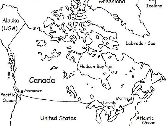
Introduce your students to CANADA with this printable handout of two worksheets (plus answer key). Your students will read a brief overview of Canada (location, capital, flag, language), write ‘Ottawa’ next to the star on the map to show the capital, color the small flag and map, and use the map and compass to answer 9 questions. Colored pencils or crayons and a pen or pencil are needed for this activity. No other prep needed.
For use with Interactive Notebooks: After the handout is completed, students can cut out the map and flag and paste into the notebook under the topic of North America / Sub-Topic: Canada. Under the map and flag, students will write a summary in their own words of what they now know about Canada.
Thank you for using my Geography worksheets in your classroom!
Included on this map: Alaska, Greenland, Iceland, United States, Arctic Ocean, Pacific, Atlantic Ocean, Vancouver, Montreal, Toronto. Cardinal, ordinal directions.
Introduce your learners to DENMARK with this two worksheets (plus answer key). Your students will read a brief introduction to Denmark (location, capital, flag, language), write ‘Copenhagen’ next to the star on the map to show the location of the capital, color a small map, and use the map and compass to answer 5 questions on page 2. Colored pencils and a pen or pencil are needed for this activity. No other prep needed. Basic Geography worksheet with a simple map to introduce Denmark and practice cardinal and ordinal directions.
For use with Interactive Notebooks: After completing the worksheets, students can cut out the map and flag of Denmark and paste into the notebook under the topic of Europe / Sub-Topic: Denmark. Under the map and flag, students can write a summary in their own words of what they now know about Denmark. Collect worksheets for other countries of Europe to add to the notebook! Please browse this store for worksheets for other countries of Europe (and beyond!).
Basic Geography worksheet with simple map includes 15 of 443 islands: Zealand, North Jutlandic, Funen, Lolland, Bornholm, Falster, Mors, Als, Langeland, Mon, Romo, Samso, Laeso, Fano, Aero. Oresund Bridge connects Copenhagen in Denmark to Malmo in Sweden. Cardinal and ordinal directions. Coloring page.
Thank you for using my Geography worksheets in your classroom! I hope you find them useful. Reviews are welcome and very much appreciated. Please follow this store for more printables.
Happy Teaching!
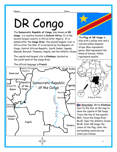
Introduce your students to the Democratic Republic of Congo (DR Congo) with this printable handout of two worksheets (plus answer key). Your students will read a brief introduction to DR Congo (location, capital, flag, language), write ‘Kinshasa’ next to the star on the map to show the capital, trace the lines to show the location of the equator and Congo River, color the small map, and use the map and compass to answer 9 questions on page 2. Colored pencils and a pen or pencil are needed for this activity. No other prep needed. Basic Geography worksheet with a simple map to introduce DR Congo and practice cardinal and ordinal directions.
For use with Interactive Notebooks: After the worksheets are completed, students can cut out the map and flag and paste into the notebook under the topic of Africa/Sub-topic: DR Congo. Under the map and flag, your students can write a summary in their own words of what they now know about this country. Collect handouts for other countries of Africa to add to the notebook! Please browse this store for a selection of printable worksheets for other countries of Africa (and beyond!).
Thank you so much for using my Geography worksheets in your classroom! I hope you find them useful! Reviews are welcome and very much appreciated!
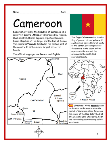
Introduce your students to CAMEROON in Africa with two worksheets (plus answer key). Your students will read a brief introduction to Cameroon (location, capital, flag, language), write ‘Yaoundé’ next to the star on the map to show the location of the capital, color the small map, and use the map and compass to answer 7 questions on page 2. Colored pencils and a pen or pencil are needed for this activity. No other prep needed. Basic Geography worksheet with a simple map to introduce Cameroon and practice cardinal/ordinal directions.
For use with Interactive Notebooks: After the worksheets are completed, students can cut out the map and flag and paste into the notebook under the topic of Africa/Sub-topic: Cameroon. Under the map and flag, your students can write a summary in their own words of what they now know about this country. Collect worksheets for other countries of Africa to add to the notebook! Available individually or as a discounted COUNTRIES OF AFRICA BUNDLE.
Thank you so much for using my Geography worksheets in your classroom! I hope you find them useful. Reviews are welcome and very much appreciated.
Included: Nigeria, Niger, Chad, Central African Republic, Equatorial Guinea, Gabon, Republic of the Congo, Gulf of Guinea, Douala.
Using the map of North Africa, find the 12 countries of the Sahara Desert in the Word Search Puzzle: Algeria, Mali, Morocco, Sudan, Chad, Mauritania, Egypt, Niger, Libya, Western Sahara, Eritrea, Tunisia.
Please browse this store for a selection of printable Geography worksheets for countries of Africa and beyond. Thank you so much for using my handouts in your classroom!
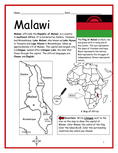
Introduce your students to MALAWI in Africa with this printable handout of two worksheets (plus answer key). Your students will read a brief introduction to Malawi (location, capital, flag, language), write ‘Lilongwe’ next to the star on the map to show the capital, color the small map, and use the map and compass to answer 7 questions on page 2. Colored pencils and a pen or pencil are needed for this activity. No other prep needed. Basic Geography worksheet includes a simple map to introduce the country of Malawi and practice cardinal/ordinal directions.
For use with Interactive Notebooks: After the worksheets are completed, students can cut out the map and flag and paste into the notebook under the topic of Africa/Sub-topic: Malawi. Under the map and flag, your students can write a summary in their own words of what they now know about this country. Collect worksheets for other countries of Africa to add to the notebook! Please browse this store for a selection of printable worksheets for other countries of Africa (and beyond!).
Thank you so much for using my Geography worksheets in your classroom! I hope you find them useful. Reviews are welcome and very much appreciated!
Introduce your students to Peru with this printable handout of two worksheets (plus answer key). Your students will read a brief overview of Peru (location, capital, flag, language), write 'Lima' next to the star on the map to show the capital, color a small map and flag, and use the map and compass to answer 7 questions. Basic Geography worksheet with a simple map to introduce Peru and practice cardinal and ordinal directions.
For use with Interactive Notebooks: After the handouts are completed, students can cut out the map and flag of Peru and paste into the notebook under the topic of South America/Sub-Topic: Peru. Under the map, your students will write a summary in their own words of what they now know about this country.
Collect handouts for other countries of South America to add to the notebook. Please browse this store for a selection of printable handouts for other countries of South America (and beyond!).
Thank you so much for using my Geography worksheets in your classroom!
Introduce your students to the country of INDONESIA with this printable handout of two worksheets (plus answer key). Your students will read a brief introduction to Indonesia (location, capital, language, flag), write ‘Jakarta’ next to the star on the map to show the location of the capital, trace the line of the equator, color the small map, and use the map and compass to answer 7 multiple-choice questions on page 2. Colored pencils and a pen or pencil are needed for this activity. No other prep needed. Basic Geography worksheet with a simple map to introduce Indonesia in Asia.
For use with Interactive Notebooks: After the worksheets are completed, students can cut out the map and flag and paste into the notebook under the topic Asia/Sub-topic: Indonesia. Under the map, your students can write a summary in their own words of what they now know about this country. Collect worksheets for other countries of Asia to add to the notebook! Please browse this store for a selection of worksheets for all other countries of Asia (and beyond!).
Thank you so much for using my Geography worksheets in your classroom! I hope you find them useful. Reviews are welcome and very much appreciated.
Included: Indian Ocean, Pacific Ocean, Java, Sumatra, Borneo, Sulawesi, New Guinea, Malaysia.
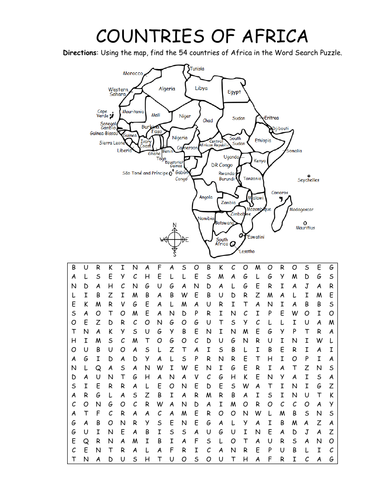
Using the map, find the 54 countries of Africa in this printable Word Search Puzzle! One printable word search puzzle with map (plus answer key).
Countries to find: ALGERIA, ANGOLA, BENIN, BOTSWANA, BURKINA FASO, BURUNDI, CAMEROON, CAPE VERDE, CENTRAL AFRICAN REPUBLIC, CHAD, COMOROS, DJIBOUTI, ESWATINI, GABON, KENYA, EGYPT, EQUATORIAL GUINEA, ERITREA, ETHIOPIA, DR CONGO, CONGO, THE GAMBIA, GHANA, GUINEA, GUINEA-BISSAU, IVORY COAST, LESOTHO, LIBERIA, LIBYA, MADAGASCAR, MALAWI, MALI, MAURITANIA, MAURITIUS, MOROCCO, MOZAMBIQUE, NAMIBIA, NIGER, NIGERIA, RWANDA, SAO TOME AND PRINCIPE, SENEGAL, SEYCHELLES, SIERRA LEONE, SOMALIA, SOUTH AFRICA, SOUTH SUDAN, SUDAN, TANZANIA, TOGO, TUNISIA, UGANDA, WESTERN SAHARA, ZIMBABWE
To introduce your learners to each country of Africa, please browse this store for printable worksheets!
Thank you so much for using my Geography worksheets in your classroom! I hope you find them useful. Reviews are welcome and very much appreciated.
Introduce your students to the country of ECUADOR in South America with this printable handout of two worksheets (plus answer key). Your students will read a brief introduction to Ecuador (location, capital, flag, language), write 'Quito' next to the star on the map to show the capital, trace the line of the equator, color the small map, and then use the map and compass to answer 7 questions on page 2. Colored pencils and a pen or pencil are needed for this activity. No other prep needed. Basic Geography worksheet with a simple map to introduce Ecuador and practice cardinal and ordinal directions.
For use with Interactive Notebooks: After the worksheets are completed, students can cut out the map and flag and paste into the notebook under the topic of South America/Sub-topic: Ecuador. Under the map and flag, your students can write a summary in their own words of what they now know about this country. Collect worksheets for all countries of South America to add to the notebook! Please browse this store for a selection of worksheets for other countries of South America (and beyond!).
Thank you so much for using my Geography worksheets in your classroom! Reviews are welcome and very appreciated. :)
Introduce your students to Sweden with two worksheets (plus answer key). Your students will read a brief introduction to Sweden (location, capital, flag, language), write 'Stockholm' next to the star on the map to show the location of the capital, draw a line from Malmö in Sweden to Copenhagen in Denmark to show the Oresund Bridge, color the small map and flag, and use the map and compass to answer 6 questions on page 2. Colored pencils and a pen or pencil are needed for this activity. No other prep needed. Basic Geography worksheet with a simple map to introduce the country of Sweden and practice cardinal and ordinal directions.
For use with Interactive Notebooks: After the worksheets are completed, students can cut out the map and flag and paste into the notebook under the topic of Europe / Sub-Topic: Sweden. Under the map, your students can write a summary in their own words of what they now know about this country. Collect worksheets for other countries of Europe to add to notebook! Please browse this store for worksheets for other countries of Europe (and beyond!).
Thank you for using my Geography worksheets in your classroom! Reviews are welcome and very much appreciated.
Introduce your students to Argentina with this printable handout of two worksheets (plus answer key). Your students will read a brief overview of Argentina (location, capital, flag, language), write 'Buenos Aires' next to the star on the map to show the capital, color the small map and flag, and use the map and compass to answer 7 questions. Colored pencils and a pen or pencil are needed for this activity. No other prep needed. Basic Geography worksheet with a simple map to introduce Argentina and practice cardinal and ordinal directions.
For use with Interactive Notebooks: After the worksheets are completed, students can cut out the map and paste into the notebook under the topic of South America/Sub-topic: Argentina. Under the map, students can write a summary in their own words of what they now know about this country. Collect worksheets for other countries of South America to add to the notebook! Please browse this store for a selection of printable worksheets for other countries of South America (and beyond)!
Thank you so much for using my Geography worksheets in your classroom!
This printable handout of one page includes a map of South America. Your students will write each country of South America on the map, using the list of countries to fill in the blanks: Argentina, Bolivia, Brazil, Chile, Colombia, Ecuador, French Guiana, Guyana, Paraguay, Peru, Suriname, Uruguay, and Venezuela, as well as the Pacific Ocean and Atlantic Ocean. Then your students can color the map. Colored pencils or crayons and a pen or pencil are needed for this activity. No other prep needed.
Mexico is located south of the United States and north of Central America. Introduce your learners to Mexico and surrounding with this printable map activity! Two worksheets (plus answer key).
Page 1:
FILL IN THE BLANKS on the map for each of the following: Alabama, Arizona, Arkansas, Atlantic Ocean, Belize, California, Caribbean Sea, Costa Rica, Cuba, El Salvador, Florida, Georgia, Guatemala, Gulf of Mexico, Honduras, Louisiana, Mexico, Mississippi, New Mexico, Nicaragua, Oklahoma, Pacific Ocean, Panama, South Carolina, Texas.
COLOR CODE: Choose a color for the United States, Mexico, Central America, and Bodies of Water. Then color the map.
Page 2: Use your completed map and compass to answer 7 questions.
Page 3: Answer Key.
Colored pencils and a pen or pencil are needed for this activity. No other prep needed.
Thank you so much for using my printables with your learners! I hope you find them useful. Reviews are welcome and very much appreciated. Please browse this store for more worksheets to introduce your learners to the countries of the world!