Thank you for visiting! Here you will find a selection of printable, interactive worksheets for your classroom: Basic Geography worksheets with simple maps, ESL, Spanish, Bible, Reading Comprehension and more. I hope you find the resources useful! Reviews are welcome and very much appreciated. Thank you so much.
Thank you for visiting! Here you will find a selection of printable, interactive worksheets for your classroom: Basic Geography worksheets with simple maps, ESL, Spanish, Bible, Reading Comprehension and more. I hope you find the resources useful! Reviews are welcome and very much appreciated. Thank you so much.
Introduce your students to the countries of Central America with this printable Word Search Puzzle! Using the map of Central America, find the 7 countries in the Word Search Puzzle: Guatemala, Belize, Honduras, El Salvador, Nicaragua, Costa Rica, and Panama.
Please browse this store for a selection of Geography worksheets to introduce your learners to the countries of Central America (and beyond!) Thank you for using my worksheets in your classroom! I hope you find them useful. Reviews are welcome and very much appreciated!
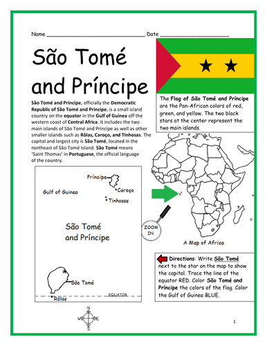
Introduce your students to the island country of São Tomé and Príncipe in Africa with this printable handout of two worksheets (plus answer key). Your students will read a brief overview of São Tomé and Príncipe (location, capital, flag, language), write ‘São Tomé’ next to the star on the map to show the capital, trace the line of the equator, color the small map, and use the map and compass to answer 8 questions on page 2. Colored pencils and a pen or pencil are needed for this activity. No other prep needed. Basic Geography worksheet with a simple map to introduce São Tomé and Príncipe and practice cardinal and ordinal directions.
For use with Interactive Notebooks: After the worksheets are completed, students can cut out the map and flag and paste into the notebook under the topic of Africa/Sub-topic: São Tomé and Príncipe. Under the map and flag, your students can write a summary in their own words of what they now know about this country. Collect handouts for other countries of Africa to add to the notebook! Please browse this store for a selection of printable worksheets for other countries of Africa and beyond!
Thank you for using my Geography worksheets in your classroom!
Introduce your learners to the state of IDAHO with this printable handout of two worksheets (plus answer key). Your students will read a brief overview of Idaho (location, capital, state bird, state flower) write ‘Boise’ next to the star on the map to show the capital, color the small map, and answer 9 questions on page 2. Colored pencils and a pen or pencil are needed for this activity. No other prep needed. Basic Geography worksheet with a simple map to introduce the state of Idaho and practice cardinal and ordinal directions.
For use with Interactive Notebooks: After the worksheet is completed, students can cut out the map and flag of Idaho and paste into the notebook under the topic of United States / Sub-Topic: Idaho. Under the map, students can write a summary in their own words of what they now know about the state of Idaho. Collect worksheets for all states of the USA to add to the notebook! Please browse this store for a selection of printable worksheets for the the states of the USA (and beyond!).
Thank you so much for using my Geography worksheets in your classroom. Reviews are welcome and very much appreciated!
Included on map: Montana, Wyoming, Nevada, Utah, Washington, Oregon, Canada. State flower Syringa. State bird Mountain Bluebird.
Using the map of the island of Hispaniola, find the countries, capitals, islands and surrounding in the Word Search Puzzle: HAITI, DOMINICAN REPUBLIC, PORT-AU-PRINCE, SANTO DOMINGO, SAONA ISLAND, BEATA ISLAND, TORTUGA ISLAND, GONAVE ISLAND, LES CAYEMITES, ILE-A-VACHE ISLAND, ATLANTIC OCEAN, CARIBBEAN SEA, CUBA. Then write the remaining letters below to spell out a fact about the island of Hispaniola! The remaining letters will spell out the following: When Christopher Columbus landed on this island of Hispaniola in 1492, he named it La Isla Espanola, which means The Spanish island.
Answer key included.
Thank you for using my worksheets in your classroom! Please browse this store for more Geography worksheets and Word Search Puzzles.
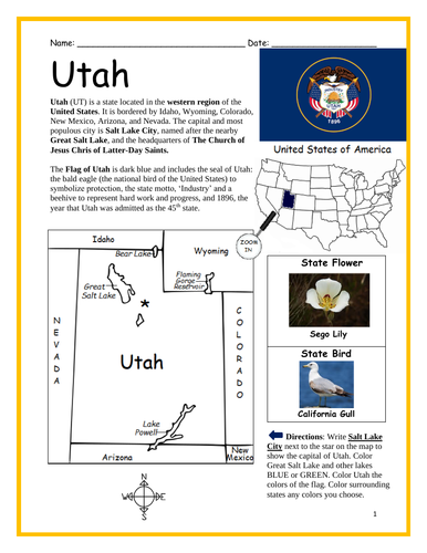
Introduce your learners to the state of UTAH with this printable handout of two worksheets (plus answer key). Your students will read a brief overview of Utah (location, capital, state bird, state flower) write ‘Salt Lake City’ next to the star on the map to show the capital, color the small map, and answer 9 questions on page 2. Colored pencils and a pen or pencil are needed for this activity. No other prep needed. Basic Geography worksheet with a simple map to introduce the state of Utah and practice cardinal and ordinal directions.
For use with Interactive Notebooks: After the worksheet is completed, students can cut out the map and flag of Utah and paste into the notebook under the topic of United States / Sub-Topic: Utah. Under the map, students can write a summary in their own words of what they now know about the state of Utah. Collect worksheets for all U.S. states to add to notebook! Please browse this store for a selection of printable worksheets for other states of the USA (and beyond!).
Thank you so much for using my Geography worksheets in your classroom! I hope you find them useful. Reviews are welcome and very much appreciated.
Map includes surrounding: Colorado, Wyoming, Idaho, Arizona, Nevada, New Mexico.
Industry. Beehive. The Church of Jesus Christ of Latter-Day Saints. Sego Lily. California Gull. Bear Lake. Great Salt Lake. Lake Powell. Flaming Gorge Reservoir.
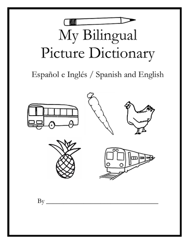
Teach Spanish and English to beginners with this printable dual-language, interactive picture dictionary. This includes 54 printable handouts with over 200 everyday, basic vocabulary words in Spanish and English with pictures to color and learn. Words are grouped into 25 topics with 6-9 pictures to color on each page, followed by a Word Review page. Teachers can cover one topic at a time. Students will save all completed handouts and staple it into a book to keep. A Cover Page, Table of Contents, and Index are included. Colored pencils or crayons are needed for this activity. No other prep needed.
Topics include:
English: bathroom, classroom, clothing, communication, containers, face, farm animals, foot, fruit, hand, kitchen, kitchen items, living room, nature, numbers, pets, sports, summer, table setting, tools, traffic light, transportation, vegetables, verbs, wild animals, winter.
Español: el baño, el salón de clases, la ropa, comunicación, contenedores, la cara, animales de la granja, el pie, la fruta, la mano, la cocina, cosas de la cocina, la sala, la naturaleza, los numeros, mascotas, los deportes, el verano, en la mesa, herramientas, el semáforo, el transporte, las verduras, verbos – acciones, animales salvajes, el invierno
Reinforce new vocabulary in Spanish and English with supplemental packets! Please click on the following links for supplemental worksheets to use with this book:
VEGETABLES / LAS VERDURAS : https://www.tes.com/teaching-resource/spanish-and-english-vegetables-12005291
NUMBERS 1-10: https://www.tes.com/teaching-resource/bilingual-numbers-1-10-spanish-and-english-12014759
The supplemental packets include 7 printable worksheets to use after completing the topic with the bilingual picture dictionary. With this supplemental packet, your students will read and write each new word, match the word in English and Spanish with the correct picture, find all new words in the Word Search, Fill-in-the-Blanks, and take the quiz. Answer key included in each packet.**
Thank you so much for using my worksheets in your classroom!
Illustrations used with permission from Pro Lingua Associates, publisher of 'Coloring in English - A Vocabulary Builder for Beginners. Coloring in English includes 400 everyday, basic vocabulary words in English with pictures to color and learn: https://prolingualearning.bookstore.ipgbook.com/coloring-in-english-products-9780866473637.php
Introduce your learners to the state of California in the USA with this printable handout of two worksheets (plus answer key). Your students will read a brief introduction to California (location, capital, flag, state bird, state flower), write ‘Sacramento’ next to the star on the map to show the capital, color the small map, and use the map and compass to answer 8 questions on page 2. Colored pencils and a pen or pencil are needed for this activity. No other prep needed. Basic Geography worksheet with a simple map to introduce California and practice cardinal and ordinal directions.
For use with Interactive Notebooks: After the worksheets are completed, students can cut out the map and flag of California and paste into the notebook under the topic of United States / Sub-Topic: California. Under the map, students can write a summary in their own words of what they now know about this state. Collect worksheets for states of the US and more to add to the notebook! Please browse this store for a selection of printable worksheets for other states of the USA (and beyond!).
Thank you for using my Geography worksheets in your classroom! I hope you find them useful. Reviews are welcome and very much appreciated.
Introduce your learners to the state of DELAWARE in the USA with this printable handout of two worksheets (plus answer key). Your students will read a brief overview of Delaware (location, capital, flag, state bird, state flower), write ‘Dover’ next to the star on the map to show the location of the capital, color the small map, and use the map and compass to answer 8 questions on page 2. Colored pencils and a pen or pencil are needed for this activity. No other prep needed. Basic Geography worksheet with a simple map to introduce the state of Delaware and practice cardinal and ordinal directions.
For use with Interactive Notebooks: After the worksheets are completed, students can cut out the map and flag of Delaware and paste into the notebook under the topic of United States / Sub-Topic: Delaware. Under the map, students can write a summary in their own words of what they now know about this state. Collect worksheets for other states of the US to add to the notebook! Please browse this store for a selection of printable worksheets for other states of the USA (and beyond!)
Thank you so much for using my worksheets in your classroom! Reviews are welcome and very much appreciated!
Included: Maryland, Pennsylvania, New Jersey, Atlantic Ocean, Delaware River, Delaware Bay, Potomac River, Wilmington DE, December 7, 1787
Introduce your learners to the country of Pakistan with this printable handout of two worksheets (plus answer key). Simple map activity and reading comprehension questions. Print and go! No prep needed.
Your students will read a brief introduction to Pakistan (location, capital, language, flag, motto), write ‘Islamabad’ next to the star on the map to show the location of the capital, color the small map, and use the map and compass to answer 7 questions on page 2. Colored pencils and a pen or pencil are needed for this activity. No other prep needed. Basic Geography worksheet with a simple map to introduce Pakistan and practice cardinal/ordinal directions.
For use with Interactive Notebooks: After the worksheets are completed, students can cut out the map and flag and paste into the notebook under the topic of (example) Countries of Asia /Sub-topic: Pakistan. Under the map, students can write a summary in their own words of what they now know about this country. Collect worksheets for other countries of Asia to add to the notebook! All available in this store.
Thank you so much for using my Geography worksheets in your classroom! I hope you find them useful. Reviews are welcome and very much appreciated. Please browse this store for more printable handouts with simple maps to introduce your learners to the countries of the world!
sped, homeschool, resource room teacher, third grade, elementary school, primary
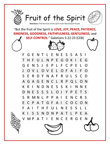
Find each FRUIT OF THE SPIRIT in the Word Search Puzzle: love, joy, peace, patience, kindness, goodness, faithfulness, gentleness, and self-control.
Bible Verse: “But the fruit of the Spirit is love, joy, peace, patience, kindness, goodness, faithfulness, gentleness, and self-control.” Galatians 5:22-23 (CEB).
Thank you so much for using my printable Bible worksheets! Please browse this store for a selection of other printable Bible worksheets for the Fruits of the Spirit and more!
Introduce your learners to the state of Virginia in the USA with this printable handout of two worksheets (plus answer key). Your students will read an introduction to Virginia (location, capital, flag, state bird, state flower), write ‘Richmond’ next to the star on the map to show the location of the capital, color the small map, and use the map and compass to answer 8 questions on page 2. Colored pencils and a pen or pencil are needed for this activity. No other prep needed. Basic Geography worksheet with a simple map to introduce the state of Virginia and practice cardinal and ordinal directions.
For use with Interactive Notebooks: After the worksheets are completed, students can cut out the map and flag of Virginia and paste into the notebook under the topic of United States / Sub-Topic: Virginia. Under the map, students can write a summary in their own words of what they now know about this state. Collect worksheets for other states of the US to add to the notebook! Please browse this store for a selection of printable Geography worksheets for other states of the USA (and beyond!).
Thank you so much for using my worksheets in your classroom. Reviews are welcome and very much appreciated!
Included: Potomac River, Atlantic Ocean, Maryland, Washington DC, North Carolina, Tennessee, Kentucky, West Virginia, Pennsylvania. Virtus Roman Goddess of bravery and strength. State motto Sic Semper Tyrannis (Thus Always to Tyrants)
Introduce your learners to MASSACHUSETTS in the USA with this printable handout of two worksheets (plus answer key). Your students will read an introduction to Massachusetts (location, capital, flag, founding year, state motto, state bird, state flower), write ‘Boston’ next to the star on the map to show the location of the capital, color the small map, state bird and flower, and use the map and compass to answer 7 multiple-choice questions on page 2. Colored pencils and a pen or pencil are needed for this activity. No other prep needed. Basic Geography worksheet with a simple map to introduce the state of Massachusetts and practice cardinal and ordinal directions.
For use with Interactive Notebooks: After the worksheets are completed, students can cut out the map, flag, state bird and flower, and paste into the notebook under the topic of United States/Sub-Topic: Massachusetts. Under the map, students can write a summary in their own words of what they now know about this state. Collect worksheets for other states of the US to add to the notebook! Please browse this store for a selection of worksheets for other states of the USA (and beyond!).
Thank you so much for using my worksheets in your classroom. Reviews are welcome and very much appreciated!
Included: Connecticut, Rhode Island, New Hampshire, Vermont, New York, Cape Cod, Nantucket Island, Martha’s Vineyard, New England, 13 colonies.
The EQUATOR runs through four continents and thirteen countries. Find the continents and countries of the equator in the Word Search Puzzle. Continents: South America, Africa, Asia, Oceania. Countries: Ecuador, Colombia, Brazil, Sao Tome and Principe, Gabon, Congo, DR Congo, Uganda, Kenya, Somalia, Maldives, Indonesia, Oceania, Kiribati.
One printable word search puzzle with map plus answer key.
Thank you so much for using this Geography Word Search Puzzle in your classroom! Reviews are welcome and very much appreciated. Please browse this store for more printable word search puzzles and Geography worksheets!
Introduce your learners to the state of OREGON in the USA with this printable handout of two worksheets (plus answer key). Your students will read a brief introduction to Oregon (location, capital, flag, state bird, state flower), write ‘Salem’ next to the star on the map to show the location of the capital, color the small map, and use the map and compass to answer 9 questions on page 2. Colored pencils and a pen or pencil are needed for this activity. No other prep needed. Basic Geography worksheet with a simple map to introduce the state of Oregon and practice cardinal and ordinal directions.
For use with Interactive Notebooks: After the worksheets are completed, students can cut out the map and flag and paste into the notebook under the topic of United States/Sub-Topic: Oregon. Under the map, students can write a summary in their own words of what they now know about this state. Collect worksheets for other states of the US and more to add to the notebook!
Please browse this store for a selection of printable worksheets for other states of the USA (and beyond!).
Thank you so much for using my worksheets in your classroom. Reviews are welcome and very much appreciated!
Included: Idaho, Washington, California, Nevada, Snake River, Columbia River, Willamette River, Goose Lake, Portland, Western Meadowlark, Oregon Grape, 1895, 33rd state of the union.
Introduce your learners to the country of Taiwan in Asia with this printable handout of two worksheets (plus answer key). Your students will read a brief introduction to Taiwan (location, capital, language, flag), write ‘Taipei’ next to the star on the map to show the location of the capital, color the small map, and use the map and compass to answer 11 questions on page 2. Colored pencils and a pen or pencil are needed for this activity. No other prep needed. Basic Geography worksheet with a simple map to introduce Taiwan and practice cardinal/ordinal directions.
For use with Interactive Notebooks: After the worksheets are completed, students can cut out the map and flag and paste into the notebook under the topic of Asia / Sub-topic: Taiwan. Under the map, students can write a summary in their own words of what they now know about this country. Collect worksheets for other countries of Asia to add to the notebook! All available in this store! Please browse this store for a selection of printable worksheets for other countries of Asia (and beyond!)
Thank you so much for using my Geography worksheets in your classroom! I hope you find them useful. Reviews are welcome and very much appreciated!
Included: Pacific Ocean, Tropic of Cancer, East Asia, Penghu archipelago, Magong, Taiwan Strait, East China Sea, South China Sea, Luzon Strait, Philippine Sea, Lu Tao, Green Island, Lan Yu, Orchid Island, blue sky, white sun, wholly red earth.
Introduce your learners to the 17 countries of the Middle East one country at a time with this bundle of printable worksheets! Countries included: Bahrain, Cyprus, Egypt, Iran, Iraq, Israel, Jodan, Kuwait, Lebanon, Oman, Palestine, Qatar, Saudi Arabia, Syria, Turkey, United Arab Emirates (UAE), and Yemen. For each country of the Middle East, your students will read a brief overview of that country (location, capital, flag, language), write the capital next to the star on the map, color the small map, and use the map and compass to answer questions on page 2. Answer key included. Basic Geography worksheets with simple maps to introduce each country of the Middle East and practice cardinal and ordinal directions.
The United Arab Emirates consists of 7 emirates. Using the map of UAE, find the 7 emirates in this word search puzzle! 7 emirates include: Abu Dhabi, Ajman, Dubai, Fujairah, Ras al Khaimah, Sharjah, Umm al Quwain. 1 printable word search puzzle (plus answer key).
Thank you so much for using my printable worksheets in your classroom! Reviews are welcome and very much appreciated. Please browse this store for more Word Search Puzzles and Geography worksheets!
Introduce your learners to United Arab Emirates in the Middle East and Asia with this printable handout of two worksheets (plus answer key). Your students will read a brief introduction to UAE (location, capital, language, flag), write ‘Abu Dhabi’ next to the star on the map to show the location of the capital, color the small map, and use the map and compass to answer 9 questions on page 2. Colored pencils and a pen or pencil are needed for this activity. No other prep needed. Basic Geography worksheet with a simple map to introduce UAE and practice cardinal/ordinal directions.
For use with Interactive Notebooks: After your students complete the worksheets, they can cut out the map and flag of UAE and paste into the notebook under the topic of Asia or Middle East / Sub-topic: United Arab Emirates. Under the map, students can write a summary in their own words of what they now know about this country. Collect worksheets for other countries of Asia or the Middle East to add to the notebook! All available in this store. Please browse this store for a selection of printable worksheets for other countries of Asia, the Middle East, and beyond!
Thank you so much for using my Geography worksheets in your classroom! I hope you find them useful. Reviews are welcome and very much appreciated.
Included: Persian Gulf, Gulf of Oman, Arabian Peninsula, maritime borders, Arabic, Pan-Arab colors, 7 emirates
Introduce your learners to the state of MISSISSIPPI in the USA with this printable handout of two worksheets (plus answer key). Your students will read a brief overview of Mississippi (location, capital, flag, state bird, state flower), trace the line of the Mississippi River, write ‘Jackson’ next to the star on the map to show the location of the capital, color the small map, and use the map and compass to answer 8 questions on page 2. Colored pencils and a pen or pencil are needed for this activity. No other prep needed. Basic Geography worksheet with a simple map to introduce the state of Mississippi and practice cardinal and ordinal directions.
For use with Interactive Notebooks: After the worksheets are completed, students can cut out the map and flag of Mississippi and paste into the notebook under the topic of United States/Sub-Topic: Mississippi. Under the map, students can write a summary in their own words of what they now know about this state. Collect worksheets for other states of the US and more to add to the notebook! Please browse this store for a selection of worksheets for other states of the USA (and beyond!).
Thank you so much for using my worksheets in your classroom! Reviews are welcome and very much appreciated.
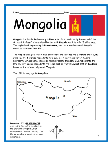
Introduce your learners to the country of Mongolia in East Asia with this printable handout of two worksheets (plus answer key). Your students will read a brief overview of Mongolia (location, capital, language, flag), write ‘Ulaanbaatar’ next to the star on the map to show the location of the capital, color the small map, and use the map and compass to answer 10 questions about Mongolia on page 2. Colored pencils and a pen or pencil are needed for this activity. No other prep needed. Basic Geography worksheet with a simple map to introduce Mongolia and practice cardinal/ordinal directions.
For use with Interactive Notebooks: After your students complete the worksheets, they can cut out the map and flag of Mongolia and paste into the notebook under the topic of Asia / Sub-topic: Mongolia. Under the map, students can write a summary in their own words of what they now know about this country. Collect worksheets for other countries of Asia to add to the notebook! Please browse this store for a selection of worksheets for other countries of Asia (and beyond!).
Thank you so much for using my Geography worksheets in your classroom! Reviews are welcome and very much appreciated.
Included: Russia, China, Soyombo, Taijitu, Mongolian, Buddhism