Thank you for visiting! Here you will find a selection of printable, interactive worksheets for your classroom: Basic Geography worksheets with simple maps, ESL, Spanish, Bible, Reading Comprehension and more. I hope you find the resources useful! Reviews are welcome and very much appreciated. Thank you so much.
Thank you for visiting! Here you will find a selection of printable, interactive worksheets for your classroom: Basic Geography worksheets with simple maps, ESL, Spanish, Bible, Reading Comprehension and more. I hope you find the resources useful! Reviews are welcome and very much appreciated. Thank you so much.
Introduce your students to DJIBOUTI in Africa with this printable handout of two worksheets (plus answer key). Your students will read a brief introduction to Djibouti (location, capital, flag, language), write ‘Djibouti’ next to the star on the map to show the capital, color the small map, and use the map and compass to answer 8 questions on page 2. Colored pencils and a pen or pencil are needed for this activity. No other prep needed. Basic Geography worksheet includes a simple map to introduce Djibouti and practice cardinal/ordinal directions.
For use with Interactive Notebooks: After the worksheets are completed, students can cut out the map and flag and paste into the notebook under the topic of Africa/Sub-topic: Djibouti. Under the map and flag, your students can write a summary in their own words of what they now know about this country. Collect handouts for other countries of Africa to add to the notebook! Please browse this store for a selection of printable handouts for other countries of Africa (and beyond!).
Thank you so much for using my Geography worksheets in your classroom! I hope you find them useful. Reviews are welcome and very much appreciated!
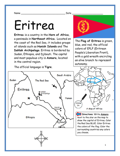
Introduce your students to ERITREA in the Horn of Africa with this printable handout of two worksheets (plus answer key). Your students will read a brief overview of Eritrea (location, capital, flag, language), write ‘Asmara’ next to the star on the map to show the capital, color the small map, and use the map and compass to answer 8 questions on page 2. Colored pencils and a pen or pencil are needed for this activity. No other prep needed. Basic Geography worksheet includes a simple map to introduce Eritrea and practice cardinal/ordinal directions.
For use with Interactive Notebooks: After the handout is completed, students can cut out the map and flag and paste into the notebook under the topic of Africa/Sub-topic: Eritrea. Under the map and flag, your students can write a summary in their own words of what they now know about this country. Collect handouts for other countries of Africa to add to the notebook! Please browse this store for a selection of printable handouts for other countries of Africa (and beyond!).
Thank you so much for using my Geography worksheets in your classroom!
Included on this map: Horn of Africa, Red Sea, Sudan, Ethiopia, Djibouti, Dahlak Archipelago, Hanish Islands.
Introduce your students to the country of SOUTH SUDAN in Africa with this printable handout of two worksheets (plus answer key). Your students will read a brief overview of South Sudan (location, capital, flag, language), write ‘Juba’ next to the star on the map to show the capital, trace the line of White Nile, color the small map, and use the map and compass to answer 9 questions on page 2. Colored pencils and a pen or pencil are needed for this activity. No other prep needed. Basic Geography worksheet includes a simple map to introduce South Sudan and practice cardinal/ordinal directions.
For use with Interactive Notebooks: After the handout is completed, students can cut out the map and flag and paste into the notebook under the topic of Africa/Sub-topic: South Sudan. Under the map and flag, your students can write a summary in their own words of what they now know about this country. Collect handouts for other countries of Africa to add to the notebook! Please browse this store for a selection of printable handouts for other countries of Africa (and beyond!).
Thank you so much for using my Geography worksheets in your classroom!
Included on this map: Sudan, Ethiopia, Kenya, Uganda, DR Congo, CAR, disputed territories Abyei Area and Ilemi Triangle. South Sudan gained independence from Sudan in 2011.
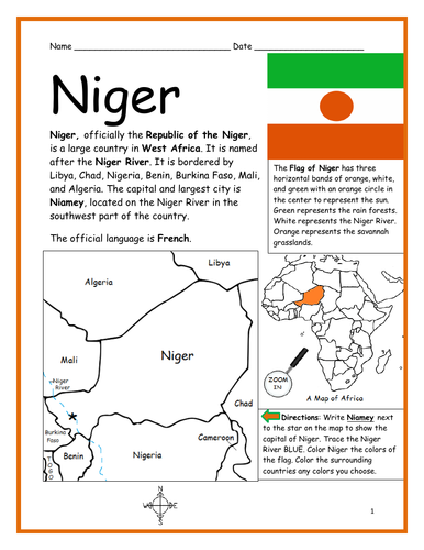
Introduce your students to the country of NIGER in Africa with this printable handout of two worksheets (plus answer key). Your students will read a brief introduction to Niger (location, capital, flag, language), write ‘Niamey’ next to the star on the map to show the capital, trace the Niger River blue, color the small map, and use the map and compass to answer 9 questions on page 2. Colored pencils and a pen or pencil are needed for this activity. No other prep needed. Basic Geography worksheet includes a simple map to introduce Niger and practice cardinal/ordinal directions.
For use with Interactive Notebooks: After the worksheets are completed, students can cut out the map and flag and paste into the notebook under the topic of Africa/Sub-topic: Niger. Under the map and flag, your students can write a summary in their own words of what they now know about this country. Collect handouts for other countries of Africa to add to the notebook! Please browse this store for a selection of printable handouts for other countries of Africa (and beyond!).
Thank you so much for using my Geography worksheets in your classroom! I hope you find them useful. Reviews are welcome and very much appreciated!
Introduce your students to the country of LIBERIA in West Africa with this printable handout of two worksheets (plus answer key). Your students will read a brief overview of Liberia (location, capital, flag, language), write ‘Monrovia’ next to the star on the map to show the capital, color the small map, and use the map and compass to answer 8 questions on page 2. Colored pencils and a pen or pencil are needed for this activity. No other prep needed. Basic Geography worksheet includes a simple map to introduce Liberia and practice cardinal/ordinal directions.
For use with Interactive Notebooks: After the handout is completed, students can cut out the map and flag and paste into the notebook under the topic of Africa/Sub-topic: Liberia. Under the map and flag, your students can write a summary in their own words of what they now know about this country. Collect handouts for other countries of Africa to add to the notebook! Please browse this store for a selection of printable handouts for other countries of Africa (and beyond!)
Thank you so much for using my Geography worksheets in your classroom!
Resource room. Homework. Interactive notebook activity.
Introduce your students to the country of TOGO in Africa with this printable handout of two worksheets (plus answer key). Your students will read a brief introduction to Togo (location, capital, flag, language), write ‘Lomé’ next to the star on the map to show the location of the capital, color the small map, and use the map and compass to answer 7 questions on page 2. Colored pencils and a pen or pencil are needed for this activity. No other prep needed. Basic Geography worksheet includes a simple map to introduce Togo and practice cardinal/ordinal directions.
For use with Interactive Notebooks: After the worksheets are completed, students can cut out the map and flag and paste into the notebook under the topic of Africa/Sub-topic: Togo. Under the map and flag, your students can write a summary in their own words of what they now know about this country. Collect handouts for other countries of Africa to add to the notebook! Please browse this store for a selection of printable handouts for other countries of Africa (and beyond!).
Thank you for using my Geography worksheets in your classroom! I hope you find them useful. Reviews are welcome and very much appreciated!
Introduce your students to the country of ANGOLA in Africa with this printable handout of two worksheets (plus answer key). Your students will read a brief introduction to Angola (location, capital, flag, language), write ‘Luanda’ next to the star on the map to show the capital, color the small map, and use the map and compass to answer 8 questions on page 2. Colored pencils and a pen or pencil are needed for this activity. No other prep needed. Basic Geography worksheet with a simple map to introduce Angola and practice cardinal/ordinal directions.
For use with Interactive Notebooks: After the worksheets are completed, students can cut out the map and flag and paste into the notebook under the topic of Africa/Sub-topic: Angola. Under the map and flag, your students can write a summary in their own words of what they now know about this country. Collect worksheets for other countries of Africa to add to the notebook! Please browse this store for a selection of printable worksheets for all other countries of Africa (and beyond!).
Thank you so much for using my Geography worksheets in your classroom! I hope you find them useful. Reviews are welcome and very much appreciated!
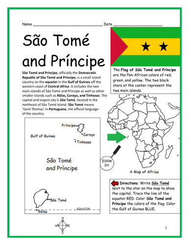
Introduce your students to the island country of São Tomé and Príncipe in Africa with this printable handout of two worksheets (plus answer key). Your students will read a brief overview of São Tomé and Príncipe (location, capital, flag, language), write ‘São Tomé’ next to the star on the map to show the capital, trace the line of the equator, color the small map, and use the map and compass to answer 8 questions on page 2. Colored pencils and a pen or pencil are needed for this activity. No other prep needed. Basic Geography worksheet with a simple map to introduce São Tomé and Príncipe and practice cardinal and ordinal directions.
For use with Interactive Notebooks: After the worksheets are completed, students can cut out the map and flag and paste into the notebook under the topic of Africa/Sub-topic: São Tomé and Príncipe. Under the map and flag, your students can write a summary in their own words of what they now know about this country. Collect handouts for other countries of Africa to add to the notebook! Please browse this store for a selection of printable worksheets for other countries of Africa and beyond!
Thank you for using my Geography worksheets in your classroom!
Introduce your learners to the state of IDAHO with this printable handout of two worksheets (plus answer key). Your students will read a brief overview of Idaho (location, capital, state bird, state flower) write ‘Boise’ next to the star on the map to show the capital, color the small map, and answer 9 questions on page 2. Colored pencils and a pen or pencil are needed for this activity. No other prep needed. Basic Geography worksheet with a simple map to introduce the state of Idaho and practice cardinal and ordinal directions.
For use with Interactive Notebooks: After the worksheet is completed, students can cut out the map and flag of Idaho and paste into the notebook under the topic of United States / Sub-Topic: Idaho. Under the map, students can write a summary in their own words of what they now know about the state of Idaho. Collect worksheets for all states of the USA to add to the notebook! Please browse this store for a selection of printable worksheets for the the states of the USA (and beyond!).
Thank you so much for using my Geography worksheets in your classroom. Reviews are welcome and very much appreciated!
Included on map: Montana, Wyoming, Nevada, Utah, Washington, Oregon, Canada. State flower Syringa. State bird Mountain Bluebird.
Using the map of the island of Hispaniola, find the countries, capitals, islands and surrounding in the Word Search Puzzle: HAITI, DOMINICAN REPUBLIC, PORT-AU-PRINCE, SANTO DOMINGO, SAONA ISLAND, BEATA ISLAND, TORTUGA ISLAND, GONAVE ISLAND, LES CAYEMITES, ILE-A-VACHE ISLAND, ATLANTIC OCEAN, CARIBBEAN SEA, CUBA. Then write the remaining letters below to spell out a fact about the island of Hispaniola! The remaining letters will spell out the following: When Christopher Columbus landed on this island of Hispaniola in 1492, he named it La Isla Espanola, which means The Spanish island.
Answer key included.
Thank you for using my worksheets in your classroom! Please browse this store for more Geography worksheets and Word Search Puzzles.
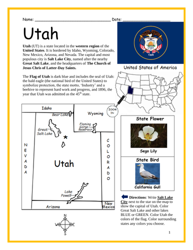
Introduce your learners to the state of UTAH with this printable handout of two worksheets (plus answer key). Your students will read a brief overview of Utah (location, capital, state bird, state flower) write ‘Salt Lake City’ next to the star on the map to show the capital, color the small map, and answer 9 questions on page 2. Colored pencils and a pen or pencil are needed for this activity. No other prep needed. Basic Geography worksheet with a simple map to introduce the state of Utah and practice cardinal and ordinal directions.
For use with Interactive Notebooks: After the worksheet is completed, students can cut out the map and flag of Utah and paste into the notebook under the topic of United States / Sub-Topic: Utah. Under the map, students can write a summary in their own words of what they now know about the state of Utah. Collect worksheets for all U.S. states to add to notebook! Please browse this store for a selection of printable worksheets for other states of the USA (and beyond!).
Thank you so much for using my Geography worksheets in your classroom! I hope you find them useful. Reviews are welcome and very much appreciated.
Map includes surrounding: Colorado, Wyoming, Idaho, Arizona, Nevada, New Mexico.
Industry. Beehive. The Church of Jesus Christ of Latter-Day Saints. Sego Lily. California Gull. Bear Lake. Great Salt Lake. Lake Powell. Flaming Gorge Reservoir.
Introduce your learners to the state of DELAWARE in the USA with this printable handout of two worksheets (plus answer key). Your students will read a brief overview of Delaware (location, capital, flag, state bird, state flower), write ‘Dover’ next to the star on the map to show the location of the capital, color the small map, and use the map and compass to answer 8 questions on page 2. Colored pencils and a pen or pencil are needed for this activity. No other prep needed. Basic Geography worksheet with a simple map to introduce the state of Delaware and practice cardinal and ordinal directions.
For use with Interactive Notebooks: After the worksheets are completed, students can cut out the map and flag of Delaware and paste into the notebook under the topic of United States / Sub-Topic: Delaware. Under the map, students can write a summary in their own words of what they now know about this state. Collect worksheets for other states of the US to add to the notebook! Please browse this store for a selection of printable worksheets for other states of the USA (and beyond!)
Thank you so much for using my worksheets in your classroom! Reviews are welcome and very much appreciated!
Included: Maryland, Pennsylvania, New Jersey, Atlantic Ocean, Delaware River, Delaware Bay, Potomac River, Wilmington DE, December 7, 1787
Introduce your learners to the state of OREGON in the USA with this printable handout of two worksheets (plus answer key). Your students will read a brief introduction to Oregon (location, capital, flag, state bird, state flower), write ‘Salem’ next to the star on the map to show the location of the capital, color the small map, and use the map and compass to answer 9 questions on page 2. Colored pencils and a pen or pencil are needed for this activity. No other prep needed. Basic Geography worksheet with a simple map to introduce the state of Oregon and practice cardinal and ordinal directions.
For use with Interactive Notebooks: After the worksheets are completed, students can cut out the map and flag and paste into the notebook under the topic of United States/Sub-Topic: Oregon. Under the map, students can write a summary in their own words of what they now know about this state. Collect worksheets for other states of the US and more to add to the notebook!
Please browse this store for a selection of printable worksheets for other states of the USA (and beyond!).
Thank you so much for using my worksheets in your classroom. Reviews are welcome and very much appreciated!
Included: Idaho, Washington, California, Nevada, Snake River, Columbia River, Willamette River, Goose Lake, Portland, Western Meadowlark, Oregon Grape, 1895, 33rd state of the union.
Introduce your learners to the country of Turkmenistan with this printable handout of two worksheets (plus answer key). Your students will read a brief introduction to Turkmenistan (location, capital, language, flag), write ‘Ashgabat’ next to the star on the map to show the location of the capital, color the small map, and use the map and compass to answer 8 questions on page 2. Colored pencils and a pen or pencil are needed for this activity. No other prep needed. Basic Geography worksheet with a simple map to introduce Turkmenistan and practice cardinal/ordinal directions.
For use with Interactive Notebooks: After the worksheets are completed, students can cut out the map and flag and paste into the notebook under the topic of Asia / Sub-topic: Turkmenistan. Under the map, students can write a summary in their own words of what they now know about this country. Collect worksheets for other countries of Asia to add to the notebook! All available in this store. Please browse this store for a selection of printable worksheets for other countries of Asia (and beyond!).
Thank you so much for using my Geography worksheets in your classroom! I hope you find them useful. Reviews are welcome and very much appreciated!
Included: Kazakhstan, Uzbekistan, Afghanistan, Iran, Caspian Sea. 5 provinces: ahal, Balkan, Dashhowuz, Lebap, and Mary.
Introduce your learners to Tajikistan in Central Asia with this printable handout of two worksheets (plus answer key). Your students will read a brief overview of Tajikistan (location, capital, language, flag), write ‘Dushanbe’ next to the star on the map to show the capital, color the small map, and use the map and compass to answer 8 true/false questions on page 2. Colored pencils and a pen or pencil are needed for this activity. No other prep needed. Basic Geography worksheet with a simple map to introduce the country of Tajikistan and practice cardinal and ordinal directions.
For use with Interactive Notebooks: After the worksheets are completed, students can cut out the map and flag and paste into the notebook under the topic of Asia / Sub-topic: Tajikistan. Under the map, students can write a summary in their own words of what they now know about this country. Collect worksheets for other countries of Asia to add to the notebook! All available in this store! Please browse this store for a selection of worksheets for other countries of Asia (and beyond!).
Thank you so much for using my Geography worksheets in your classroom. I hope you find them useful. Reviews are welcome and very much appreciated!
Included: Afghanistan, Uzbekistan, Kyrgyzstan, China, Tajiks, Tajiki, Crown, Islam
Introduce your learners to the country of Timor-Leste, also known as East Timor, in Southeast Asia with this printable handout of two worksheets (plus answer key). Your students will read a brief introduction to Timor-Leste (location, capital, language, flag), write ‘Dili’ next to the star on the map to show the capital, color the small map, and use the map and compass to answer 8 true/false questions on page 2. Colored pencils and a pen or pencil are needed for this activity. No other prep needed. Basic Geography worksheet with a simple map to introduce the island country of Timor-Leste and practice cardinal and ordinal directions.
For use with Interactive Notebooks: After the worksheets are completed, students can cut out the map and flag and paste into the notebook under the topic of Asia / Sub-topic: Timor-Leste. Under the map, students can write a summary in their own words of what they now know about this country. Collect worksheets for other countries of Asia to add to the notebook! All available in this store! Please browse this store for a selection of worksheets for other countries of Asia (and beyond!).
Thank you so much for using my Geography worksheets in your classroom! I hope you find them useful. Reviews are welcome and very much appreciated!
Included: Timor Sea, Portuguese, Tetum
Introduce your students to CHAD with two worksheets (plus answer key). Your students will read a brief introduction to Chad (location, capital, flag, language), write ‘N’Djamena’ next to the star on the map to show the location of the capital, color the small map, and use the map and compass to answer 9 questions on page 2. Colored pencils and a pen or pencil are needed for this activity. No other prep needed. Basic Geography worksheet with a simple map to introduce the country of Chad and practice cardinal/ordinal directions.
For use with Interactive Notebooks: After the worksheets are completed, students can cut out the map and flag and paste into the notebook under the topic of Africa/Sub-topic: Chad. Under the map and flag, your students can write a summary in their own words of what they now know about this country. Collect worksheets for other countries of Africa to add to the notebook! Please browse this store for a selection of worksheets for all other countries of Africa (and beyond!).
Thank you so much for using my Geography worksheets in your classroom! I hope you find them useful. Reviews are welcome and very much appreciated.
Introduce your learners to the state of North Dakota in the USA with this printable handout of two worksheets (plus answer key). Your students will read a brief overview of North Dakota (location, capital, flag, state bird, state flower), write ‘Bismarck’ next to the star on the map to show the location of the capital, trace the lines of the Missouri River and Red River BLUE, color the small map, state bird and flower, and use the map and compass to answer 10 true/false questions on page 2. Colored pencils and a pen or pencil are needed for this activity. No other prep needed. Basic Geography worksheet with a simple map to introduce the state of North Dakota and practice cardinal and ordinal directions.
For use with Interactive Notebooks: After the worksheets are completed, students can cut out the map, flag, state bird and flower of North Dakota and paste into the notebook under the topic of United States/Sub-Topic: North Dakota. Under the map, students can write a summary in their own words of what they now know about this state. Collect worksheets for other states of the United States to add to the notebook! Please browse this store for a selection of worksheets for other states of the USA (and beyond!).
Thank you so much for using my worksheets in your classroom! Reviews are welcome and very much appreciated.
Included: Fargo, Dakota Native American Tribe, State Motto E Pluribus Unum, Western Meadowlark, Wild Prairie Rose, Lake Sakakawea, Minnesota, South Dakota, Montana, Canada, Great Plains Region, Dakota Territory.
Introduce your learners to the state of South Dakota in the USA with this printable handout of two worksheets (plus answer key). Your students will read a brief overview of South Dakota (location, capital, flag, state bird, state flower), write ‘Pierre’ next to the star on the map to show the location of the capital, trace the lines of the Missouri River and Red River BLUE, color the small map, state bird and flower, and use the map and compass to answer 10 true/false questions on page 2. Colored pencils and a pen or pencil are needed for this activity. No other prep needed. Basic Geography worksheet with a simple map to introduce the state of South Dakota and practice cardinal and ordinal directions.
For use with Interactive Notebooks: After the worksheets are completed, students can cut out the map, flag, state bird and flower and paste into the notebook under the topic of United States/Sub-Topic: South Dakota. Under the map, students can write a summary in their own words of what they now know about this state. Collect worksheets for other states of the United States to add to the notebook! Please browse this store for a selection of worksheets for other states of the USA (and beyond!).
Thank you so much for using my worksheets in your classroom! Reviews are welcome and very much appreciated.
Included: Mount Rushmore, Ring-necked Pheasant, American Pasque, Sioux Falls, 1889, East River, West River, Black Hills, Great Plains region, North Dakota, Minnesota, Iowa, Nebraska, Wyoming, Montana, mid-west region.
Introduce your learners to the US state of Iowa with this printable handout of two worksheets (plus answer key). Your students will read a brief overview of Iowa (location, capital, flag, state bird, state flower), write ‘Des Moines’ next to the star on the map to show the location of the capital, trace the lines of the Des Moines River, Mississippi River and Missouri River, color the small map, state bird and flower, and use the map and compass to answer 10 true/false questions on page 2. Colored pencils and a pen or pencil are needed for this activity. No other prep needed. Basic Geography worksheet with a simple map to introduce the state of Iowa and practice cardinal and ordinal directions.
For use with Interactive Notebooks: After the worksheets are completed, students can cut out the map, flag, state bird and flower and paste into the notebook under the topic of United States/Sub-Topic: Iowa. Under the map, students can write a summary in their own words of what they now know about this state. Collect worksheets for other states of the United States to add to the notebook! Please browse this store for a selection of worksheets for other states of the USA (and beyond!)
Thank you so much for using my worksheets in your classroom! Reviews are welcome and very much appreciated.
Included: midwestern region, Des Moines pronunciation, American Goldfinch, Prairie Rose, Ioway, Bald Eagle, state motto: Our Liberties we prize and our rights we will remain. Wisconsin, Illinois, Missouri, Nebraska, South Dakota, Minnesota.