Thank you for visiting! Here you will find a selection of printable, interactive worksheets for your classroom: Basic Geography worksheets with simple maps, ESL, Spanish, Bible, Reading Comprehension and more. I hope you find the resources useful! Reviews are welcome and very much appreciated. Thank you so much.
Thank you for visiting! Here you will find a selection of printable, interactive worksheets for your classroom: Basic Geography worksheets with simple maps, ESL, Spanish, Bible, Reading Comprehension and more. I hope you find the resources useful! Reviews are welcome and very much appreciated. Thank you so much.
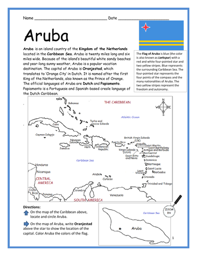
Introduce your learners to ARUBA with two worksheets (plus answer key). Your students will read a brief introduction to Aruba (location, capital, flag, language), locate and circle the island of Aruba on the map of the Caribbean (map 1), write ‘Oranjestad’ next to the star on the map of Aruba (map 2) to show the location of the capital, color the small map, and then use the reading passage, maps and compass to answer 10 true/false questions on page 2. Colored pencils and a pen or pencil are needed for this activity. No other prep needed. Basic Geography worksheet with simple maps to introduce Aruba and practice cardinal and ordinal directions.
For use with Interactive Notebooks: After the worksheets are completed, students can cut out the maps and flag and paste into the notebook under the topic of (example) The Caribbean / Sub-topic: Aruba. Under the map, your students can write a summary in their own words of what they now know about Aruba. Collect worksheets of other countries to add to the notebook! Please browse this store for worksheets to introduce your students to the islands of the Caribbean and beyond!
Thank you so much for using my Geography worksheets in your classroom! I hope you find them useful. Reviews are welcome and very much appreciated!
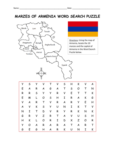
Using the map, find the 10 marzes and the capital of Armenia in the word search puzzle: Aragatsotn, Ararat, Armavir, Gegharkunik, Kotayk, Lori, Shirak, Syunik, Tavush, Vatots Dzor, Yerevan. One printable word search puzzle plus answer key.
Thank you so much for using my Geography worksheets in your classroom! I hope you find them useful. Reviews are welcome and very much appreciated! Please browse this store for more worksheets to introduce your learners to the countries of the world!
Introduce your learners to Saint Barthélemy (also known as St. Barts) with two printable handouts (plus answer key). Your students will read a brief introduction to Saint Barthélemy (location, capital, flag, language), write ‘Gustavia’ next to the star on the map to show the location of the capital, locate and circle Saint Barthélemy on the map of the Caribbean, color the maps, and use the reading passage, maps and compass to answer 9 true/false questions on page 2. Colored pencils and a pen or pencil are needed for this activity. No other prep needed. Basic Geography worksheet with a simple map to introduce Saint Barthélemy and practice cardinal and ordinal directions. Print and Go!
For use with Interactive Notebooks: After the worksheets are completed, students can cut out the map and flag and paste into the notebook under the topic of (example) The Caribbean / Sub-topic: Saint Barthélemy. Under the map, your students can write a summary in their own words of what they now know about Saint Barthélemy. Collect worksheets of other countries to add to the notebook! All available in this store!
Thank you so much for using my Geography worksheets with your students! I hope you find them useful. Reviews are welcome and very much appreciated! Please browse this store for a selection of worksheets to introduce your learners to the countries of the world!
Included: France, Caribbean Sea. Simple map includes islands of Lle Fregate, Lle Chevreau, La Tortue (aka Turtle Island), Lle Coco, Les Saintes.
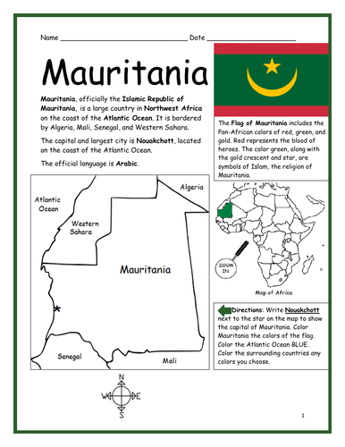
Introduce your students to the country of MAURITANIA in Africa with this printable handout of two worksheets (plus answer key). Your students will read a brief overview of Mauritania (location, capital, flag, language), write ‘Nouakchott’ next to the star on the map to show the capital, color the small map, and use the map and compass to answer 8 questions on page 2. Colored pencils and a pen or pencil are needed for this activity. No other prep needed. Basic Geography worksheet with a simple map to introduce the country of Mauritania and practice cardinal/ordinal directions.
For use with Interactive Notebooks: After the handout is completed, students can cut out the map and flag and paste into the notebook under the topic of Africa/Sub-topic: Mauritania. Under the map and flag, your students can write a summary in their own words of what they now know about this country. Collect handouts for other countries of Africa to add to the notebook! Please browse this store for a selection of printable handouts for other countries of Africa (and beyond!)
Thank you for using my Geography worksheets in your classroom!
Introduce your students to the 11 regions of Armenia! This includes the capital city of Yerevan and 10 regions (also known as marzer or marzes) and the capitals: Aragatsotn (Ashtarak), Ararat (Artashat), Armavir (Armavir), Gegharkunik (Gavar), Kotayk (Hrazdan), Lori (Vanadzor), Shirak (Gyumri), Syunik (Kapan), Tavush (Ljevan), Vatots Dzor (Yeghegnadzor).
Your students will use the list of marzes and capitals on page 2 to write the name of the capital of each marz on the map of Armenia. Then they will use the reading passage, maps and compass to answer 10 true/false questions on page 3. Answer key included.
Please browse this store for more worksheets to introduce your learners to Armenia and other countries of Europe (and beyond!)
Thank you so much for using my Geography worksheets in your classroom! I hope you find them useful. Reviews are welcome and very much appreciated!
Teach your students about Africa with this packet of 7 printable worksheets.
Page 1 is a list of the 54 countries of Africa in alphabetical order.
Page 2 is a map of Africa. Your students will write the name of each country on the map.
Page 3: Word Search: Find African countries A-L.
Page 4: Word Search: Find African countries M-Z.
Pages 5-6: List the 54 countries of Africa A-Z (your students will see how many they can remember on their own before referring to the list and map).
Page 7: Languages of Africa. Fill in the blank.
Thank you for using my Geography worksheets in your classroom!
This dual-language vocabulary packet includes 7 printable worksheets for teaching Vegetables in Spanish and English (plus answer key for quiz). Use this packet as a supplement to the Printable Bilingual Picture Dictionary, or on its own.
Page 1: Read and write the vegetable in Spanish and English - page 1.
Page 2: Read and write the vegetable in Spanish and English - page 2.
Page 3: Draw a line from each word in Spanish and English to the correct vegetable.
Page 4: Word Search - Search for the vegetables in English.
Page 5: Word Search - Search for the vegetables in Spanish.
Page 6: Fill in the blank - Spanish and English.
Page 7: Quiz: Write the word in Spanish and English next to the vegetable.
Page 8: Answer Key.
Thank you for using my printable handouts in your classroom! Reviews are welcome and very much appreciated.
Illustrations are used with permission from ProLingua Learning, publisher of Coloring in English - A Vocabulary Builder for Beginners. This book includes 400 everyday, basic vocabulary words in English with pictures to color and learn.
https://prolingualearning.bookstore.ipgbook.com/coloring-in-english-products-9780866473637.php
This dual-language vocabulary packet includes 6 printable worksheets for teaching NUMBERS 1-10 in Spanish and English (plus answer key for quiz). Use this packet as a supplement to the Printable Bilingual Picture Dictionary, or on its own.
Los números en Español e Ingles
Page 1: Read and write numbers 1-5 in Spanish and English.
Page 2: Read and write numbers 6-10 in Spanish and English
Page 3: Draw a line from each word in Spanish and English to the correct number.
Page 4: Word Search - Search for numbers 1-10 in Spanish and English.
Page 5: Fill in the blank for each number in Spanish and English.
Page 6: Quiz: Write the word in Spanish and English next to the number.
Page 7: Answer Key.
Thank you for using my printable handouts in your classroom! Reviews are welcome and very much appreciated.
Illustrations are used with permission from Pro Lingua Associates, publisher of Coloring in English - A Vocabulary Builder for Beginners. Coloring in English includes 400 everyday, basic vocabulary words in English with pictures to color and learn.
This packet of printable handouts can be used as a supplement to the printable book https://www.tes.com/teaching-resource/my-spanish-picture-dictionary-11829384 or on its own.
This packet includes WINTER vocabulary words in SPANISH: winter, coat, hat, gloves, mittens, snowman, boots, scarf, sled, skate. Español: el invierno, el patín, las botas, el abrigo, el trineo, el muñeco de nieve, la bufanda, los mitones, los guantes, el gorro
Page 1: Read and write the Winter word in Spanish. 1-5
Page 2: Read and write the Winter word in Spanish. 6-9
Page 3: Match the Winter word in Spanish with the correct picture.
Page 4: Word Search - Find the Winter words in Spanish.
Page 5: QUIZ: Write the correct Winter word in Spanish next to each picture.
Page 6: Quiz Answer Key.
Page 7: Word Search Answer Key.
Thank you so much for using my printable worksheets in your classroom!
Introduce your learners to St. Patrick’s Day and the country of Ireland with this resource combo! Two resources included:
ST. PATRICK’S DAY PRINTABLE WORKSHEETS: Why is St. Patrick’s Day celebrated on March 17? Why do people wear green? What are shamrocks and why do we see them everywhere on St. Patrick’s Day? Your students will read a short passage about St. Patrick’s Day and answer the questions that follow. Includes multiple-choice questions, cloze activity/fill-in-the-blanks. 2 worksheets (plus answer key).
IRELAND - INTRODUCTORY GEOGRAPHY WORKSHEET: Introduce your learners to Ireland with this printable handout of two worksheets (plus answer key). Your students will read a brief overview of Ireland (location, capital, flag, language), write ‘Dublin’ next to the star on the map to show the location of the capital, color the small map and flag, and use the map and compass to answer 6 multiple-choice questions on page 2. Colored pencils or and a pen or pencil are needed for this activity. No other prep needed. Basic Geography worksheet with a simple map to introduce the country of Ireland. - 2 worksheets (plus answer key).
6 pages total.
Thank you so much for using my worksheets in your classroom! Reviews are welcome and very much appreciated.
Can your students name all 50 states of the United States of America? This bundle includes a printable map of the United States to color and learn; a printable map where your students will write the name of each state on the map, a printable worksheet where your students will fill in the blank letters for each US State, and a Word Search Puzzle where your students will find all 50 states in the puzzle and then write the leftover letters to spell out a fun-fact about the United States. (The ‘fun fact’ from the leftover letters will read: The longest boardwalk in the world is located in the United States in New Jersey in Atlantic City.) Also included is a blank State Fact Sheet that your students can use to research a specific state. The Pledge of Allegiance worksheet to match the word to the definition (pledge, allegiance, republic, indivisible, liberty, justice).
Thank you so much for using my printable worksheets in your classroom!
Learn about New York with this bundle of printable Geography handouts:
New York: 2 worksheets (plus answer key). Your students will read a brief overview of New York (location, capital, state bird, state flower, abbreviation), write ‘Albany’ next to the star on the map to show the capital of New York, color a small map and then use the map and compass to answer 8 questions.
Long Island: 2 worksheets (plus answer key). Your students will read a brief overview of Long Island, color a small map, and use the map and compass to answer 8 questions. Map includes Suffolk County, Nassau County, Queens and Brooklyn, separated by the Bronx and Manhattan by the East River. Atlantic Ocean, Long Island Sound, Hudson River, The Hamptons, North Fork, South Fork, Montauk.
Northeastern Region of the United States: 2 worksheets (plus answer key). This list includes 11 states: The states of New England: Maine (ME), New Hampshire (NH), Vermont (VT), Massachusetts (MA), Rhode Island (RI), and Connecticut (CT), and the Middle States: New York (NY), Pennsylvania (PA), New Jersey (NJ) and Delaware (DE). Your students will write the full name of each state on the map, then color the six states of New England one color and the middle states another color. Then they will use the map and compass to answer six questions.
Color the map of the United States: 1 printable handout with map to color.
For use with Interactive Notebooks: After the handout is completed and the map is colored and questions are answered, cut out the map and paste it into the notebook under the topic of United States / sub-topic New York. Under the map, students will write a summary in their own words of what they now know about the state/region.
This bundle includes printable handouts for North and South Korea to cover each country separately, plus printable handouts for Korea.
North Korea: Teach your students about North Korea with this printable handout of 2 worksheets (plus answer key). Your students will read a brief overview of North Korea, write 'Pyongyang’ next to the star on the map to show the capital of North Korea, write DMZ on the border of North and South Korea to show the location of the Korean Demilitarized Zone, color the small flag and map, and use the map and compass to answer 10 questions.
South Korea: Teach your students about South Korea with this printable handout of 2 worksheets (plus answer key). Your students will read a brief overview of South Korea, write 'Seoul’ next to the star on the map to show the capital of South Korea, color a small flag and map, and use the map and compass to answer 7 questions.
KOREA: Teach your students about KOREA with this printable handout of two pages (plus answer key). Your students will read a brief overview of Korea (located in East Asia, consists of North and South Korea, bordered by China, Russia, and Japan and surrounded by the Sea of Japan, Yellow Sea, Korea Bay, and Korea Strait). Your students will color a small map of Korea and surrounding area and then use the map and compass to answer five questions.
Introduce your learners to the books of the bible with this bundle of 13 printable handouts! Challenging but fun, this bundle of printable activities will help your students learn to list (and spell!) each book of the Old and New Testament! Print and Go!
Resources included in this bundle:
-Word Search Puzzle for Old Testament
-Word Search Puzzle for New Testament
-Fill in the blanks of the books of the Old Testament
-Fill in the blanks of the books of the New Testament
-Unscramble the books of the Old Testament
-Unscramble the books of the New Testament
Books of the New Testament: Matthew, Mark, Luke, John, Acts, Romans, 1 Corinthians, 2 Corinthians, Galatians, Ephesians, Philippians, Colossians, 1 Thessalonians, 2 Thessalonians, 1 Timothy, 2 Timothy, Titus, Philemon, Hebrews, James, 1 Peter, 2 Peter, 1 John, 2 John, 3 John, Jude, Revelation
Books of the Old Testament: Genesis, Exodus, Leviticus, Numbers, Deuteronomy, Joshua, Judges, Ruth, 1 Samuel, 2 Samuel, 1 Kings, 2 Kings, 1 Chronicles, 2 Chronicles, Ezra, Nehemiah, Esther, Job, Psalms, Proverbs, Ecclesiastes, Song of Solomon, Isaiah, Jeremiah, Lamentations, Ezekiel, Daniel, Hosea, Joel, Amos, Obadiah, Jonah, Micah, Nahum, Habakkuk, Zephaniah, Haggai, Zechariah, Malachi
Thanks so much for using my worksheets in your classroom! I hope you find them useful. Reviews are welcome and very much appreciated. Please Follow Me for more printables!
Thank you again!
This packet includes a worksheet for each chapter of ‘Tales of a Fourth Grade Nothing’ by Judy Blume. After reading each chapter, readers can complete the worksheet/s for that chapter. Includes word search puzzles, fill-in-the-blanks, matching activities, sequencing and crosswords for reading comprehension and vocabulary building. 17 pages. Answer Key included.
Worksheets are black and white (with small pictures to color as an option).
Thank you for using this pack of worksheets! I hope you find them useful! Reviews are welcome and very much appreciated. If you are continuing with the Fudge series, printable worksheets for each chapter of Fudge-A-Mania are also available!
Thank you again.
This packet includes printable handouts for each chapter of ‘Fudge-A-Mania’ by Judy Blume. After reading a chapter of the book, your students will complete the handout/s for that chapter. The handouts include cloze exercises, fill-in-the-blank, matching activities and crossword puzzles for reading comprehension and vocabulary building. 21 printable handouts. Answer Key included.
Thank you for using my worksheets in your classroom! Reviews are welcome and very much appreciated.
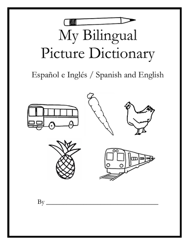
Teach Spanish and English to beginners with this printable dual-language, interactive picture dictionary. This includes 54 printable handouts with over 200 everyday, basic vocabulary words in Spanish and English with pictures to color and learn. Words are grouped into 25 topics with 6-9 pictures to color on each page, followed by a Word Review page. Teachers can cover one topic at a time. Students will save all completed handouts and staple it into a book to keep. A Cover Page, Table of Contents, and Index are included. Colored pencils or crayons are needed for this activity. No other prep needed.
Topics include:
English: bathroom, classroom, clothing, communication, containers, face, farm animals, foot, fruit, hand, kitchen, kitchen items, living room, nature, numbers, pets, sports, summer, table setting, tools, traffic light, transportation, vegetables, verbs, wild animals, winter.
Español: el baño, el salón de clases, la ropa, comunicación, contenedores, la cara, animales de la granja, el pie, la fruta, la mano, la cocina, cosas de la cocina, la sala, la naturaleza, los numeros, mascotas, los deportes, el verano, en la mesa, herramientas, el semáforo, el transporte, las verduras, verbos – acciones, animales salvajes, el invierno
Reinforce new vocabulary in Spanish and English with supplemental packets! Please click on the following links for supplemental worksheets to use with this book:
VEGETABLES / LAS VERDURAS : https://www.tes.com/teaching-resource/spanish-and-english-vegetables-12005291
NUMBERS 1-10: https://www.tes.com/teaching-resource/bilingual-numbers-1-10-spanish-and-english-12014759
The supplemental packets include 7 printable worksheets to use after completing the topic with the bilingual picture dictionary. With this supplemental packet, your students will read and write each new word, match the word in English and Spanish with the correct picture, find all new words in the Word Search, Fill-in-the-Blanks, and take the quiz. Answer key included in each packet.**
Thank you so much for using my worksheets in your classroom!
Illustrations used with permission from Pro Lingua Associates, publisher of 'Coloring in English - A Vocabulary Builder for Beginners. Coloring in English includes 400 everyday, basic vocabulary words in English with pictures to color and learn: https://prolingualearning.bookstore.ipgbook.com/coloring-in-english-products-9780866473637.php
Introduce your students to the 5 regions of the United States with this bundle of printable handouts. Each region includes one printable handout (plus answer key) with a simple map. For each region, students will refer to the map to find each country in the Word Search Puzzle.
Western Region includes: Alaska, California, Colorado, Hawaii, Idaho, Montana, Nevada, Oregon, Utah, Washington, Wyoming.
Southwest Region includes: Arizona, New Mexico, Texas, Oklahoma.
Northeast Region includes: Connecticut, Maine, Massachusetts, New Hampshire, Rhode Island, Vermont, Delaware, Maryland, New Jersey, New York, Pennsylvania.
Midwest Region includes: Iowa, Kansas, Missouri, Nebraska, North Dakota, South Dakota, Illinois, Indiana, Michigan, Minnesota, Ohio, Wisconsin.
Southeast Region includes: Virginia, North Carolina, South Carolina, Georgia, Florida, Alabama, Arkansas, Kentucky, Louisiana, Mississippi, Tennessee, West Virginia.
Thank you so much for using my Geography worksheets in your classroom!
Introduce your students to Central America one country at a time with a worksheet for each country!
Every country of Central America includes a printable handout of 2 pages (plus answer key). Page 1: Read a brief introduction to the country (location, capital, flag, language), write the capital next to the star on the map, color the small map and flag. Page 2: Use the map and compass to answer questions and identify locations of surrounding countries.
For use with Interactive Notebooks: After the worksheets for a country are completed, students cut out the map and flag and paste into the notebook under the topic of Central America. Under the map and flag, students can write a summary of what they now know about that country. Add a country until all of Central America is complete!
Worksheets also included in this bundle:
-Fill in the Blanks on the Map of Central America. Cut and paste into notebook.
-Cut out each flag and paste into the map of Central America.
Thank you so much for using my worksheets in your classroom! I hope you find them useful. Reviews are welcome and very much appreciated!
Introduce your learners to the 7 countries ending in ‘stan’ in Asia with this bundle of printable worksheets! Countries included:
AFGHANISTAN
KAZAKHSTAN
KYRGYZSTAN
PAKISTAN
TAJIKISTAN
TURKMENISTAN
UZBEKISTAN
For each country, your students will read a brief introduction to that country (location, capital, flag, language), write the name of the capital next to the star on the map, color the small map, and use the map and compass to answer questions on page 2. Basic Geography worksheets with simple maps to introduce each country and practice cardinal and ordinal directions. 2 worksheets per country (plus answer key).
For use with Interactive Notebooks: After the worksheet for the country is completed, students can cut out the map and flag and paste into the notebook under the topic of The Stans (or Asia) / Sub-Topic: (country). Under the map, students can write a summary in their own words about what they now know about that country! Add each country until the stans are complete!
Also included: The Stans Countries Printable Map and Word Search Puzzle Activity
Thank you so much for using my Geography worksheets in your classroom! I hope you find them useful. Reviews are welcome and very much appreciated!