Thank you for visiting! Here you will find a selection of printable, interactive worksheets for your classroom: Basic Geography worksheets with simple maps, ESL, Spanish, Bible, Reading Comprehension and more. I hope you find the resources useful! Reviews are welcome and very much appreciated. Thank you so much.
Thank you for visiting! Here you will find a selection of printable, interactive worksheets for your classroom: Basic Geography worksheets with simple maps, ESL, Spanish, Bible, Reading Comprehension and more. I hope you find the resources useful! Reviews are welcome and very much appreciated. Thank you so much.
Introduce your students to ICELAND with two worksheets (plus answer key). Your students will read a brief overview of Iceland (location, capital, flag, language), write ‘Reykjavík’ next to the star on the map to show the location of the capital, color the map, and use the map and compass to answer 6 questions on page 2. Colored pencils and a pen or pencil are needed for this activity. No other prep needed. Basic Geography worksheet with a simple map to introduce Iceland and practice cardinal/ordinal directions.
For use with Interactive Notebooks: After completing the worksheets, students can cut out the map and flag and paste into the notebook under the topic of Europe / Sub-Topic: Iceland. Under the map and flag, students can write a summary in their own words of what they now know about this country. Collect worksheets for other countries of Europe to add to the notebook! Please browse this store for worksheets for other countries of Europe (and beyond!).
Thank you so much for using my worksheets in your classroom! I hope you find them useful. Reviews are welcome and very much appreciated!
Introduce your students to Ethiopia with two worksheets (plus answer key). Your students will read a brief introduction to Ethiopia (location, capital, flag, language), write ‘Addis Ababa’ next to the star on the map to show the location of the capital, color the small map, and use the map and compass to answer 8 questions on page 2. Colored pencils and a pen or pencil are needed for this activity. No other prep needed. Basic Geography worksheet includes a simple map to introduce the country of Ethiopia and practice cardinal/ordinal directions.
For use with Interactive Notebooks: After the worksheets are completed, students can cut out the map and flag and paste into the notebook under the topic of Africa / Sub-topic: Ethiopia. Under the map and flag, your students can write a summary in their own words of what they now know about Ethiopia. Collect worksheets for other countries of Africa to add to the notebook! Please browse this store for worksheets for other countries of Africa (and beyond!).
Thank you so much for using my Geography worksheets in your classroom! I hope you find them useful. Reviews are welcome and very much appreciated!
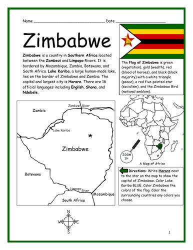
Introduce your students to ZIMBABWE in Africa with this printable handout of two worksheets (plus answer key). Your students will read a brief introduction to Zimbabwe (location, capital, flag, language), write ‘Harare’ next to the star on the map to show the capital, color the small map, and use the map and compass to answer 9 questions on page 2. Colored pencils and a pen or pencil are needed for this activity. No other prep needed. Basic Geography worksheet includes a simple map to introduce the country of Zimbabwe and practice cardinal/ordinal directions.
For use with Interactive Notebooks: After the worksheets are completed, students can cut out the map and flag and paste into the notebook under the topic of Africa/Sub-topic: Zimbabwe. Under the map and flag, your students can write a summary in their own words of what they now know about this country. Collect handouts for other countries of Africa to add to the notebook! Please browse this store for a selection of printable handouts for other countries of Africa (and beyond!).
Thank you so much for using my Geography worksheets in your classroom!
Included in resource: Lake Kariba, Zambezi River, Limpopo River, South Africa, Botswana, Zambia, Mozambique.
Resource Room
Introduce your students to SOMALIA in Africa with this printable handout of two worksheets (plus answer key). Your students will read a brief introduction to Somalia (location, capital, flag, language), write ‘Mogadishu’ next to the star on the map to show the capital, trace the line of the equator, color the small map, and use the map and compass to answer 9 questions on page 2. Colored pencils and a pen or pencil are needed for this activity. No other prep needed. Basic Geography worksheet includes a simple map to introduce Somalia and practice cardinal/ordinal directions.
For use with Interactive Notebooks: After the worksheets are completed, students can cut out the map and flag and paste into the notebook under the topic of Africa/Sub-topic: Somalia (or Horn of Africa). Under the map and flag, your students can write a summary in their own words of what they now know about this country. Collect handouts for other countries of Africa to add to the notebook! Please browse this store for a selection of printable handouts for other countries of Africa (and beyond!).
Thank you for using my Geography worksheets in your classroom! I hope you find them useful. Reviews are welcome and very much appreciated!
Included on map: Horn of Africa, Ethiopia, Djibouti, Kenya, Gulf of Aden, Somali Sea, Indian Ocean, Equator
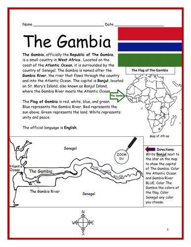
Introduce your students to THE GAMBIA in Africa with this printable handout of two worksheets (plus answer key). Your students will read a brief introduction to The Gambia (location, capital, flag, language), write ‘Banjul’ next to the star on the map to show the capital, color the small map, and use the map and compass to answer 7 questions on page 2. Colored pencils and a pen or pencil are needed for this activity. No other prep needed. Basic Geography worksheet includes a simple map to introduce The Gambia and practice cardinal/ordinal directions.
For use with Interactive Notebooks: After the worksheets are completed, students can cut out the map and flag and paste into the notebook under the topic of Africa/Sub-topic: The Gambia. Under the map and flag, your students can write a summary in their own words of what they now know about this country. Collect handouts for other countries of Africa to add to the notebook! Please browse this store for a selection of printable Geography worksheets for other countries of Africa (and beyond!).
Thank you so much for using my Geography worksheets in your classroom! I hope you find them useful. Reviews are welcome and very much appreciated!
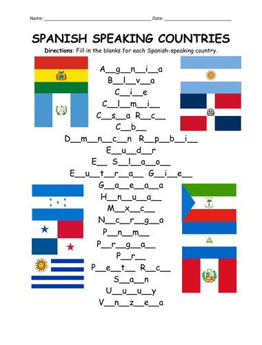
Fill in the blanks for each Spanish-speaking country using the list of countries on page 2. Countries included: Argentina, Bolivia, Chile, Colombia, Costa Rica, Cuba, Dominican Republic, Ecuador, El Salvador, Equatorial Guinea, Guatemala, Honduras, Mexico, Nicaragua, Panama, Paraguay, Peru, Puerto Rico, Spain, Uruguay, Venezuela.
For individual worksheets to introduce each Spanish-speaking country, please browse this store! Basic Geography worksheets with simple maps.
Thank you so much for using my worksheets in your classroom! I hope you find them useful. Reviews are welcome and very much appreciated!
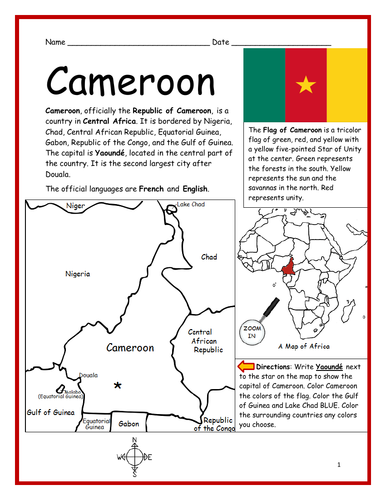
Introduce your students to CAMEROON in Africa with two worksheets (plus answer key). Your students will read a brief introduction to Cameroon (location, capital, flag, language), write ‘Yaoundé’ next to the star on the map to show the location of the capital, color the small map, and use the map and compass to answer 7 questions on page 2. Colored pencils and a pen or pencil are needed for this activity. No other prep needed. Basic Geography worksheet with a simple map to introduce Cameroon and practice cardinal/ordinal directions.
For use with Interactive Notebooks: After the worksheets are completed, students can cut out the map and flag and paste into the notebook under the topic of Africa/Sub-topic: Cameroon. Under the map and flag, your students can write a summary in their own words of what they now know about this country. Collect worksheets for other countries of Africa to add to the notebook! Available individually or as a discounted COUNTRIES OF AFRICA BUNDLE.
Thank you so much for using my Geography worksheets in your classroom! I hope you find them useful. Reviews are welcome and very much appreciated.
Included: Nigeria, Niger, Chad, Central African Republic, Equatorial Guinea, Gabon, Republic of the Congo, Gulf of Guinea, Douala.
The EQUATOR runs through four continents and thirteen countries. Find the continents and countries of the equator in the Word Search Puzzle. Continents: South America, Africa, Asia, Oceania. Countries: Ecuador, Colombia, Brazil, Sao Tome and Principe, Gabon, Congo, DR Congo, Uganda, Kenya, Somalia, Maldives, Indonesia, Oceania, Kiribati.
One printable word search puzzle with map plus answer key.
Thank you so much for using this Geography Word Search Puzzle in your classroom! Reviews are welcome and very much appreciated. Please browse this store for more printable word search puzzles and Geography worksheets!
Introduce your learners to United Arab Emirates in the Middle East and Asia with this printable handout of two worksheets (plus answer key). Your students will read a brief introduction to UAE (location, capital, language, flag), write ‘Abu Dhabi’ next to the star on the map to show the location of the capital, color the small map, and use the map and compass to answer 9 questions on page 2. Colored pencils and a pen or pencil are needed for this activity. No other prep needed. Basic Geography worksheet with a simple map to introduce UAE and practice cardinal/ordinal directions.
For use with Interactive Notebooks: After your students complete the worksheets, they can cut out the map and flag of UAE and paste into the notebook under the topic of Asia or Middle East / Sub-topic: United Arab Emirates. Under the map, students can write a summary in their own words of what they now know about this country. Collect worksheets for other countries of Asia or the Middle East to add to the notebook! All available in this store. Please browse this store for a selection of printable worksheets for other countries of Asia, the Middle East, and beyond!
Thank you so much for using my Geography worksheets in your classroom! I hope you find them useful. Reviews are welcome and very much appreciated.
Included: Persian Gulf, Gulf of Oman, Arabian Peninsula, maritime borders, Arabic, Pan-Arab colors, 7 emirates
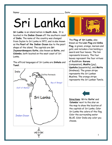
Introduce your learners to the country of Sri Lanka in South Asia with two worksheets (plus answer key). Your students will read a brief introduction to Sri Lanka (location, capital, language, flag), write ‘Kotte’ and ‘Colombia’ next to the star on the map to show the location of the capitals, color the small map, and use the map and compass to answer 7 true/false questions on page 2. Colored pencils and a pen or pencil are needed for this activity. No other prep needed. Basic Geography worksheet with a simple map to introduce Sri Lanka and practice cardinal and ordinal directions.
For use with Interactive Notebooks: After the worksheets are completed, students can cut out the map and flag and paste into the notebook under the topic of Asia / Sub-topic: Sri Lanka. Under the map, students can write a summary in their own words of what they now know about this country. Collect worksheets for other countries of Asia to add to the notebook! All available in this store!
Thank you so much for using my Geography worksheets in your classroom! I hope you find them useful. Reviews are welcome and very much appreciated! Please browse this store for worksheets to introduce your students to the countries of Asia and around the world!
Included: Lion Flag, Sinha, Sri Jayewardenepura Kotte, Pearl of the Indian Ocean, India, Ceylon, Pearl of the Indian Ocean, Bay of Bengal
Introduce your students to CHILE in South America with this black & white printable handout of two worksheets (plus answer key). Your students will read a brief overview of Chile (location, capital, flag, language), write ‘Santiago’ next to the star on the map to show the location of the capital, color the map and flag, and use the map and compass to answer 9 questions on page 2. Colored pencils and a pen or pencil are needed for this activity. No other prep needed. Basic Geography worksheet with a simple map to introduce the country of Chile and practice cardinal and ordinal directions.
This worksheet is printable in black and white. Thank you so much for using my Geography worksheets in your classroom! Reviews are welcome and very much appreciated!
Introduce your students to the country of INDONESIA with this printable handout of two worksheets (plus answer key). Your students will read a brief introduction to Indonesia (location, capital, language, flag), write ‘Jakarta’ next to the star on the map to show the location of the capital, trace the line of the equator, color the small map, and use the map and compass to answer 7 multiple-choice questions on page 2. Colored pencils and a pen or pencil are needed for this activity. No other prep needed. Basic Geography worksheet with a simple map to introduce Indonesia in Asia.
For use with Interactive Notebooks: After the worksheets are completed, students can cut out the map and flag and paste into the notebook under the topic Asia/Sub-topic: Indonesia. Under the map, your students can write a summary in their own words of what they now know about this country. Collect worksheets for other countries of Asia to add to the notebook! Please browse this store for a selection of worksheets for all other countries of Asia (and beyond!).
Thank you so much for using my Geography worksheets in your classroom! I hope you find them useful. Reviews are welcome and very much appreciated.
Included: Indian Ocean, Pacific Ocean, Java, Sumatra, Borneo, Sulawesi, New Guinea, Malaysia.
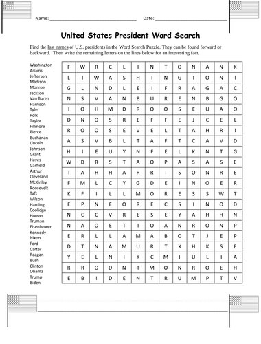
Find the last names of U.S. presidents in the Word Search puzzle with this printable worksheet (1 page plus answer key). The names can be found forward or backward. Then write the remaining letters on the lines below for an interesting fact about a U.S. president.
Leftover letters will spell out: Franklin D. Roosevelt was the first president to appear on the TV.
List of last names included to find in puzzle: Washington, Adams, Jefferson, Madison, Monroe, Jackson, Van Buren, Harrison, Tyler, Polk, Taylor, Fillmore, Pierce, Buchanan, Lincoln, Johnson, Grant, Hayes, Garfield , Arthur, Cleveland, McKinley, Roosevelt, Taft, Wilson, Harding, Coolidge, Hoover, Truman, Eisenhower, Kennedy, Nixon, Ford, Carter, Reagan, Bush, Clinton, Obama, Trump, Biden.
Thank you so much for using my worksheets in your classroom! Please browse this store for a selection of other worksheets for the USA (and beyond)!
On the map of the United States of America, write the name of the capital for each state of the USA. One printable worksheet with map (plus answer key).
For individual worksheets to introduce your learners to the 50 states of the USA (and beyond!) please browse this store!
Thank you so much for using my Geography worksheets in your classroom! Reviews are welcome and very much appreciated.
States and Capitals:
Alabama - Montgomery
Alaska - Juneau
Arizona - Phoenix
Arkansas - Little Rock
California - Sacramento
Colorado - Denver
Connecticut - Hartford
Delaware - Dover
Florida - Tallahassee
Georgia - Atlanta
Hawaii - Honolulu
Idaho - Boise
Illinois - Springfield
Indiana - Indianapolis
Iowa - Des Moines
Kansas - Topeka
Kentucky - Frankfort
Louisiana - Baton Rouge
Maine - Augusta
Maryland - Annapolis
Massachusetts - Boston
Michigan - Lansing
Minnesota - St. Paul
Mississippi - Jackson
Missouri - Jefferson City
Montana - Helena
Nebraska - Lincoln
Nevada - Carson City
New Hampshire - Concord
New Jersey - Trenton
New Mexico - Santa Fe
New York - Albany
North Carolina - Raleigh
North Dakota - Bismarck
Ohio - Columbus
Oklahoma - Oklahoma City
Oregon - Salem
Pennsylvania - Harrisburg
Rhode Island - Providence
South Carolina - Columbia
South Dakota - Pierre
Tennessee - Nashville
Texas - Austin
Utah - Salt Lake City
Vermont - Montpelier
Virginia - Richmond
Washington - Olympia
West Virginia - Charleston
Wisconsin - Madison
Wyoming - Cheyenne
ntroduce your students to Brazil with this printable handout of two worksheets (plus answer key). Your students will read a brief overview of Brazil (location, capital, flag, language), write 'Brasília' next to the star on the map to show the capital, write the national motto of Brazil 'ERDEM E PROGRESSO' on the band of the flag, color the flag and map, and use the map and compass to answer 9 questions on page 2. Basic Geography worksheet with a simple map to introduce Brazil and practice cardinal and ordinal directions.
For use with Interactive Notebooks: After the handout is completed, cut out the map and flag and paste into the notebook under the topic of South America/Sub-Topic Brazil. Under the map and flag, your students will write a summary in their own words of what they now know about Brazil. Collect handouts for other countries of South America to add to the notebook! Please browse this store for a selection of printable handouts for other countries of South America (and beyond!).
Thank you so much for using my Geography worksheets in your classroom!
coloring page, cardinal, ordinal, Portuguese
Introduce your students to the country of Belarus with two printable worksheets (plus answer key). Instant download. Print and go!
Your students will read a brief introduction to Belarus (location, capital, flag, language), write 'Minsk' next to the star on the map to show the location of the capital, color the small map and flag, and use the map and compass to answer 6 questions on page 2. Colored pencils and a pen or pencil are needed for this activity. No other prep needed. Basic Geography worksheet with a simple map to introduce Belarus and practice cardinal/ordinal directions.
For use with Interactive Notebooks: After the worksheets are completed, students can cut out the map and flag and paste into the notebook under the topic of (example) Countries of Europe/Sub-topic: Belarus. Under the map, students can write a summary in their own words of what they now know about this country. Collect worksheets for other countries of Europe to add to the notebook! All available in this store. Please browse this store for a selection of worksheets for other countries of Europe with simple maps.
Thank you so much for using my Geography worksheets in your classroom! I hope you find them useful. Reviews are welcome and very much appreciated!
Introduce your students to Bolivia with this printable handout of two worksheets (plus answer key). Your students will read a brief overview of Bolivia (location, capital, flag, language), write 'Sucre' next to the star on the map to show the capital, color the small map and flag, and use the map and compass to answer 7 questions. Colored pencils and a pen or pencil are needed for this activity. No other prep needed. Basic Geography worksheet with a simple map to introduce Bolivia and practice cardinal and ordinal directions.
For use with Interactive Notebooks: After the handout is completed, students can cut out the map and flag and paste into the notebook under the topic of South America/Sub-topic: Bolivia. Under the map, students will write a summary in their own words of what they now know about this country. Collect handouts for other countries of South America to add to the notebook! Please browse this store for a selection of printable handouts for other countries of South America (and beyond!).
Thank you so much for using my Geography worksheets in your classroom!
Introduce your learners to AUSTRIA with two worksheets (plus answer key). Your students will read a brief introduction to Austria (location, capital, flag, language), write ‘Vienna’ next to the star on the map to show the location of the capital, color the small map and flag, and use the map and compass to answer 7 questions on page 2. Colored pencils and a pen or pencil are needed for this activity. No other prep needed. Basic Geography worksheet with a simple map to introduce Austria and practice cardinal and ordinal directions.
For use with Interactive Notebooks: After the worksheets are completed, students can cut out the map and flag and paste into the notebook under the topic of Europe / Sub-topic: Austria. Under the map, students can write a summary in their own words of what they now know about Austria. Collect worksheets for other countries of Europe to add to the notebook! All available in this store! Please browse this store for a selection of printable Geography worksheets for other countries of Europe (and beyond!).
Thank you for using my Geography worksheets in your classroom! I hope you find them useful. Reviews are welcome and very much appreciated!
German
Introduce your students to CHILE in South America with this printable handout of two worksheets (plus answer key). Your students will read a brief overview of Chile (location, capital, flag, language), write 'Santiago' next to the star on the map to show the capital, color the small map, and use the map and compass to answer 8 questions on page 2. Basic Geography worksheet with a simple map to introduce Chile and practice cardinal and ordinal directions.
For use with Interactive Notebooks: After the handout is completed, students can cut out the map and paste into the notebook under the topic South America/Sub-Topic Chile. Under the map, your students will write a summary in their own words of what they now know about Chile. Collect handouts for each country of South America to add to the notebook! Please browse this store for a selection of printable handouts for other countries of South America (and beyond!).
Thank you so much for using my Geography worksheets in your classroom!
Drake Passage, Juan Fernández, San Félix, Isla Salas y Gómez, Easter Island.
Introduce your students to North Korea with this printable handout of 2 worksheets (plus answer key). Your students will read a brief introduction to North Korea (location, capital, flag, language), write 'Pyongyang’ next to the star on the map to show the location of the capital, write DMZ on the border of North and South Korea to show the location of the Korean Demilitarized Zone, color the small flag and map, and use the map and compass to answer 9 questions on page 2. Colored pencils and a pen or pencil are needed for this activity. No other prep needed. Basic Geography worksheet with a simple map to introduce North Korea.
For use with Interactive Notebooks: After the worksheets are completed, students can cut out the map and flag and paste into the notebook under the topic of Asia/Sub-Topic: North Korea. Under the map, students can write a summary in their own words of what they now know about North Korea. Collect handouts for other countries of Asia to add to the notebook! Please browse this store for a selection of printable handouts for other countries of Asia (and beyond!).
Thank you so much for using my Geography worksheets in your classroom! I hope you find them useful. Reviews are welcome and very much appreciated! Please browse this store for worksheets with simple maps to introduce your learners to the countries of the world!