Thank you for visiting! Here you will find a selection of printable, interactive worksheets for your classroom: Basic Geography worksheets with simple maps, ESL, Spanish, Bible, Reading Comprehension and more. I hope you find the resources useful! Reviews are welcome and very much appreciated. Thank you so much.
Thank you for visiting! Here you will find a selection of printable, interactive worksheets for your classroom: Basic Geography worksheets with simple maps, ESL, Spanish, Bible, Reading Comprehension and more. I hope you find the resources useful! Reviews are welcome and very much appreciated. Thank you so much.
Introduce your learners to Afghanistan with two worksheets (plus answer key). Your students will read a brief introduction to Afghanistan (location, capital, language, flag), write ‘Kabul’ next to the star on the map to show the location of the capital, color the small map, and use the map and compass to answer questions on page 2. Colored pencils and a pen or pencil are needed for this activity. No other prep needed. Basic Geography worksheet with a simple map to introduce Afghanistan and practice cardinal/ordinal directions.
For use with Interactive Notebooks: After completing the worksheet, students can cut out the map and paste into the notebook under the topic Asia/Sub-topic: Afghanistan. Under the map, students can write a summary in their own words of what they now know about this country. Collect worksheets for other countries of Asia to add to the notebook! Please browse this store for a selection of printable worksheets for other countries of Asia (and beyond!)
Thank you so much for using my Geography worksheets. I hope you find them useful! Reviews are welcome and very much appreciated.
Read some basic facts about the FLY and then answer 8 True/False questions. 2 printable worksheets plus answer key.
Facts included: The fly has two wings. They can fly up, down, side to side and even backwards; Flies have big eyes that can see in all directions at all times; Flies don’t have teeth. They have a long tongue that acts like a straw. They drink their food instead of eat it; Flies have sticky feet that can grip almost any surface. Their feet can taste food!; Flies have a lifespan of about one month. That is, unless a frog, bird or snake get to it first. Flies can be tasty meals for some critters!
Thank you so much for using my worksheets! I hope you find them useful. Please browse this store for a selection of printable worksheets! :)
Introduce your learners to the continent of ANTARCTICA with this printable worksheet of 2 pages (plus answer key). Your students will read a brief overview of Antarctica (location, climate, etc), color a small map, and answer 7 true/false questions on page 2. Basic Geography worksheet with a simple map to introduce the continent of Antarctica.
Thank you so much for using my Geography worksheets!
Includes: Victoria Land, Wilkes Land, Ice Shelves: Ross, Ronne, and Amery.
Using the map of the continent of Oceania, find the 14 island countries in the Word Search Puzzle. They can be found forward or backward. One printable worksheet (plus answer key). Countries included: Australia, Papua New Guinea, New Zealand, Fiji, Solomon Islands, Vanuatu, Samoa, Kiribati, Micronesia, Tonga, Marshall Islands, Palau, Tuvalu, Nauru.
Thank you so much for using my Geography worksheets! I hope you find them useful. Reviews are welcome and very much appreciated. Please browse this store for more Geography worksheets and Word Search Puzzles.
Introduce your learners to the country of Samoa in Oceania with two interactive worksheets (plus answer key). Your students will read a brief introduction to Samoa (location, capital, flag, language), locate and circle Samoa on the map of Oceania, write ‘Apia’ next to the star on the map of Samoa to show the location of the capital, color the small map, and use the map and compass to answer 7 multiple-choice questions on page 2. Colored pencils and a pen or pencil are needed for this activity. No other prep needed. Basic Geography worksheet with a simple map to introduce Samoa and practice cardinal and ordinal directions.
For use with Interactive Notebooks: After your students complete the worksheets, they can cut out the map and flag and paste into the notebook under the topic of (example) Oceania/Sub-Topic: Samoa. Under the map and flag, students can write a summary in their own words of what they now know about Samoa. Collect worksheets for other countries of Oceania to add to the notebook! Please browse this store for a selection of worksheets for other countries of Oceania (and beyond!).
Thank you so much for using my Geography worksheets in your classroom! I hope you find them useful and fun. Reviews are welcome and very much appreciated.
Introduce your learners to the African Great Lakes with two printable worksheets (plus answer key). Simple map activity and reading comprehension questions. Your students will read a short passage about the African Great Lakes, trace the lines of each of the 9 Great Lakes on map 1 and color the lakes and surrounding countries. The African Great Lakes include: Lake Victoria, Lake Tanganyika, Lake Malawi, Lake Turkana, Lake Albert, Lake Edward, Lake Kivu, Lake Rukwa, and Lake Mweru. On map 2, a small map of Africa, place a blue dot to show the location of each of the 9 Great Lakes, then using the maps, answer 5 multiple choice questions on page 2.
Countries of the African Great Lakes Region included on this map: Uganda, Kenya, Tanzania, Malawi, the Democratic Republic of the Congo (DR Congo), Burundi and Rwanda. Also included on map: Mozambique, Zambia, Ethiopia and South Sudan.
If you’d like to introduce your learners to the 10 COUNTRIES of the African Great Lakes region, do so one country at a time with a printable worksheet for each country! Available individually or as a discounted bundle! Please click on this link for more info: https://www.tes.com/teaching-resource/african-great-lakes-region-countries-introductory-worksheets-bundle-12777435
Thank you so much for using my Geography worksheets in your classroom! I hope you find them useful. Reviews are welcome and very much appreciated. Please browse this store for a selection of printable Geography worksheets to introduce your students to the countries of the world!
Introduce your learners to the 9 African Great Lakes with this free printable map and word search puzzle! Using the map, find the 9 African Great Lakes in the Word Search Puzzle. Lakes to find: TURKANA, VICTORIA, TANGANYIKA, RUKWA, MALAWI, MWERU, KIVU, EDWARD, ALBERT. One printable handout plus answer key.
If you’d like to introduce your learners to the 10 COUNTRIES of the African Great Lakes region, do so one country at a time with a printable worksheet for each country! Countries included: Burundi, Democratic Republic of the Congo, Ethiopia, Kenya, Malawi, Mozambique, Rwanda, Tanzania, Uganda, Zambia. Worksheets available individually or as a discounted bundle! Please click on this link for more info: https://www.tes.com/teaching-resource/african-great-lakes-region-countries-introductory-worksheets-bundle-12777435
Thank you for using my Geography worksheets! I hope you find them useful. Reviews are welcome and very much appreciated! Please browse this store for a selection of printable worksheets to introduce your learners to the countries of the world!
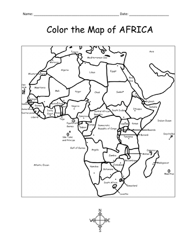
Print and color the map of Africa! This printable coloring sheet of one page includes the 54 countries of Africa to color and learn.
Thank you so much for using my Geography worksheets and coloring pages. Please browse this store for a selection of printable worksheets for countries of Africa and beyond!
This printable map of Asia includes all 50 countries (list below). 1 printable page. Prints in black and white. Instant download. Print and go! Use as a reference or print to color and learn! and learn the map of Asia with this printable coloring page.
Countries included: Afghanistan, Armenia, Azerbaijan, Bahrain, Bangladesh, Bhutan, Brunei, Cambodia, China, Cyprus, Georgia, India, Indonesia, Iran, Iraq, Israel, Japan, Jordan, Kazakhstan, Kuwait, Kyrgyzstan, Laos, Lebanon, Malaysia, Maldives, Mongolia, Myanmar, Nepal, North Korea, Oman, Pakistan, Palestine, Philippines, Qatar, Russia, Saudi Arabia, Singapore, South Korea, Sri Lanka, Syria, Taiwan, Tajikistan, Thailand, Timor-Leste, Turkey, Turkmenistan, UAE (United Arab Emirates) , Uzbekistan, Vietnam, and Yemen. Also the Arctic Ocean, Pacific Ocean, Indian Ocean and surrounding parts of Europe and Africa.
Thank you for using this printable map of Asia with your learners! I hope you find it useful. Please browse this store for more printable worksheets with simple maps to introduce your students to the countries of the world!
Introduce your learners to the GREAT LAKES of North America with this printable handout of two worksheets (plus answer key). Your students will write the names of the 5 Great Lakes on the map, color the map (Great Lakes, Canada, United States) and use the map to answer 9 questions on page 2.
Included on this map: Lake Superior; Lake Michigan; Lake Huron; Lake Erie; Lake Ontario; Canada Provinces Ontario and Quebec; US States: Minnesota; Wisconsin; Iowa; Illinois; Indiana; Michigan; Ohio; Pennsylvania; New York.
Thank you for using my Geography worksheets! Please browse this store for a selection of printable Geography worksheets for North America and beyond.
Using the map of North America, find the names of the 5 Great Lakes in the Word Search Puzzle. Answer Key included.
5 Great Lakes: Superior, Michigan, Huron, Erie, Ontario.
Do your learners like using Word Search Puzzles to learn new things? Please browse this store for a selection of other printable Word Search Puzzles!
Thank you so much for using my printables. Happy Teaching!
Introduce your students to the country of JORDAN with two worksheets (plus answer key). Your students will read a brief introduction to Jordan (location, capital, language, flag), write ‘Amman’ next to the star on the map to show the location of the capital, color the small map, and use the map and compass to answer 9 questions on page 2. Colored pencils and a pen or pencil are needed for this activity. No other prep needed. Basic Geography worksheet with a simple map to introduce Jordan and practice cardinal/ordinal directions.
For use with Interactive Notebooks: After the worksheets are completed, students can cut out the map and flag an paste into the notebook under the topic of Asia or Middle East /Sub-topic: Jordan. Under the map, your students can write a summary in their own words of what they now know about this country. Collect worksheets for other countries of Asia or Middle East to add to the notebook! All available in this store. Please browse this store for a selection of printable Geography worksheets for other countries of Asia, Middle East and beyond!
Thank you so much for using my Geography worksheets in your classroom! I hope you find them useful. Reviews are welcome and very much appreciated!
Hashemite Kingdom of Jordan, Western Asia, Middle East, Saudi Arabia, Iraq, Syria, Israel, Palestinian West Ban, Dead Sea, Red Sea, Amman, Arabic, Pan-Arab, Al-Fatiha
Introduce your learners to the U.S. state of KANSAS with two worksheets (plus answer key). Your students will read a brief introduction to Kansas (location, capital, flag, state bird, state flower), write ‘Topeka’ next to the star on the map to show the location of the capital, trace the line of the Kansas River blue, color the small map of Kansas and surrounding states, color the state bird and state flower (Western Meadowlark and Sunflower) and use the map and compass to answer 9 questions on page 2. Colored pencils and a pen or pencil are needed for this activity. No other prep needed. Basic Geography worksheet with a simple map to introduce the state of Kansas and practice cardinal and ordinal directions.
For use with Interactive Notebooks: After the worksheets are completed, students can cut out the map, flag, state bird and state flower, and paste into the notebook under the topic of United States / Sub-Topic: Kansas. Under the map, students can write a summary in their own words of what they now know about this state. Collect worksheets for all U.S. states to add to notebook! Please browse this store for worksheets for other states of the USA (and beyond!).
Thank you so much for using my Geography worksheets in your classroom! I hope you find them useful. Reviews are welcome and very much appreciated.
Wichita, 34th state, Kansa Native Americans, Midwestern region, Nebraska, Missouri, Oklahoma, Colorado, Sunflower, Western Meadowlark
Introduce your students to the country of KUWAIT with this printable handout of two worksheets (plus answer key). Your students will read a brief introduction to Kuwait (location, capital, language, flag), write ‘Kuwait City’ next to the star on the map to show the location of the capital, color the small map, and use the map and compass to answer 8 questions on page 2. Colored pencils and a pen or pencil are needed for this activity. No other prep needed. Basic Geography worksheet with a simple map to introduce the country of Kuwait and practice cardinal/ordinal directions.
For use with Interactive Notebooks: After the worksheets are completed, students can cut out the map and flag and paste into the notebook under the topic of Asia (or Middle East) /Sub-topic: Kuwait. Under the map, your students can write a summary in their own words of what they now know about this country. Collect handouts for other countries of Asia or Middle East to add to the notebook! Please browse this store for a selection of Geography worksheets for other countries of Asia, the Middle East and beyond!
Thank you so much for using my Geography worksheets in your classroom! I hope you find them useful. Reviews are welcome and very much appreciated!
Introduce your students to the country of LEBANON with this printable handout of two worksheets (plus answer key). Your students will read a brief introduction to Lebanon (location, capital, language, flag), write ‘Beirut’ next to the star on the map to show the capital, color the small map, and use the map and compass to answer 7 questions on page 2. Colored pencils and a pen or pencil are needed for this activity. No other prep needed. Basic Geography worksheet with a simple map to introduce Lebanon and practice cardinal/ordinal directions.
For use with Interactive Notebooks: After your students complete the handout, they can cut out the map and and flag and paste into the notebook under the topic of Asia (or Middle East) /Sub-topic: Lebanon. Under the map, your students can write a summary in their own words of what they now know about this country. Collect handouts for other countries of Asia or Middle East to add to the notebook! Please browse this store for a selection of printable handouts for other countries of Asia, the Middle East, and beyond!
Thank you so much for using my Geography worksheets in your classroom! I hope you find them useful. Reviews are welcome and very much appreciated! Please browse this store for more worksheets to use in your classroom!
Mediterranean Sea
Resource Room
Using the map of the Middle East, fill in the blank letters for each of the 17 countries: Bahrain, Cyprus, Egypt, Iran, Iraq, Israel, Jordan, Kuwait, Lebanon, Oman, Palestine, Qatar, Saudi Arabia, Syria, Turkey, UAE (United Arab Emirates), Yemen.
Thank you for using my printable handouts in your classroom! Please browse this store for a selection of Geography worksheets for countries of the Middle East (and beyond!).
Introduce your students to the Maldives in South Asia with this printable handout of two worksheets (plus answer key). Your students will read a brief introduction to Maldives (location, capital, language, flag), write ‘Malé’ next to the star on the map to show the capital, trace the line of the equator, color the small map, and use the map and compass to answer 8 questions on page 2. Colored pencils and a pen or pencil are needed for this activity. No other prep needed. Basic Geography worksheet with a simple map to introduce the Maldives and practice cardinal/ordinal directions.
For use with Interactive Notebooks: After the worksheets are completed, students can cut out the map and flag and paste into the notebook under the topic of Asia/Sub-topic: Maldives. Under the map, your students can write a summary in their own words of what they now know about this country. Collect worksheets for other countries of Asia to add to the notebook! Please browse this store for a selection of printable handouts for other countries of Asia (and beyond!).
Thank you so much for using my Geography worksheets in your classroom! I hope you find them useful. Reviews are welcome and very much appreciated! Please browse this store for printable worksheets to introduce your students to the countries of the world!
Introduce your students to Saudi Arabia with this printable handout of two worksheets (plus answer key). Your students will read a brief overview of Saudi Arabia (location, capital, language, flag), write ‘Riyadh’ next to the star on the map to show the capital, color the small map, and use the map and compass to answer 9 questions on page 2. Colored pencils and a pen or pencil are needed for this activity. No other prep needed. Basic Geography worksheet with a simple map to introduce Saudi Arabia and practice cardinal/ordinal directions.
For use with Interactive Notebooks: After your students complete the handout, they can cut out the map and paste into the notebook under the topic Asia or Middle East/Sub-topic: Saudi Arabia. Under the map, your students can write a summary in their own words of what they now know about this country. Collect handouts for other countries of Asia or the Middle East to add to the notebook! Please browse this store for a selection of printable handouts for other countries of the Middle East, Asia, and beyond!
Thank you so much for using my Geography worksheets in your classroom!
Inclued: Jordan, Iraq, Kuwait, Qatar, Bahrain, United Arab Emirates, Oman, Yemen, Israel, Egypt, Red Sea, Persian Gulf.
Introduce your students to the country of Australia with this printable handout of two worksheets (plus answer key). Your students will read a brief overview of Australia (location, capital, flag), write ‘Canberra’ next to the star on the map to show the capital, color the small map, and use the map and compass to answer 6 questions on page 2. Colored pencils and a pen or pencil are needed for this activity. Basic Geography worksheet with a simple map to introduce the country of Australia and practice cardinal and ordinal directions.
For use with Interactive Notebooks: After the handout is completed, students can cut out the map and flag of Australia and paste into the notebook. Under the map and flag, students can write a summary in their own words of what they now know about this country. Collect handouts for other countries to add to the notebook. Please browse this store for a selection of printable Geography worksheets!
Thank you so much for using my Geography worksheets in your classroom!
Included: Indian Ocean, Pacific Ocean, Sydney, Melbourne, Brisbane, Perth, Adelaide.
Introduce your students to the country of INDONESIA with this printable handout of two worksheets (plus answer key). Your students will read a brief introduction to Indonesia (location, capital, language, flag), write ‘Jakarta’ next to the star on the map to show the location of the capital, trace the line of the equator, color the small map, and use the map and compass to answer 7 multiple-choice questions on page 2. Colored pencils and a pen or pencil are needed for this activity. No other prep needed. Basic Geography worksheet with a simple map to introduce Indonesia in Asia.
For use with Interactive Notebooks: After the worksheets are completed, students can cut out the map and flag and paste into the notebook under the topic Asia/Sub-topic: Indonesia. Under the map, your students can write a summary in their own words of what they now know about this country. Collect worksheets for other countries of Asia to add to the notebook! Please browse this store for a selection of worksheets for all other countries of Asia (and beyond!).
Thank you so much for using my Geography worksheets in your classroom! I hope you find them useful. Reviews are welcome and very much appreciated.
Included: Indian Ocean, Pacific Ocean, Java, Sumatra, Borneo, Sulawesi, New Guinea, Malaysia.