I'm a teacher and the Author of the Amazon e-book;' Time Smart Teaching' and my mission is to create Geography resources to help teachers save time and reduce their workload. I am sharing additional time saving tips for teachers on my YOUTUBE channel ' Time Smart Teaching' if you fancy dropping by!
I'm a teacher and the Author of the Amazon e-book;' Time Smart Teaching' and my mission is to create Geography resources to help teachers save time and reduce their workload. I am sharing additional time saving tips for teachers on my YOUTUBE channel ' Time Smart Teaching' if you fancy dropping by!
This 4th lesson in our cold climate series ’ Pole to Pole’ allows students to discover Antarctica through a virtual Antarctic cruise. They will learn to annotate the Antarctic icy landscape and discover what tourist activities away those on the cruise. We also compare how the Arctic is different from the Antarctic using a true or false quiz- the students find the answer by studying and comparing the 2 maps of the poles.
Most countries devise their electricity generation mean through a mix of fossil fuels and renewable energy resources. This A3 revision poster gets students analysing energy mix trends from pie charts located onto the world map. The original map is available as a free download from the EDF energy website; edfenergy.com/energy/education however a large copy is made available on the second slide of the powerpoint. Students answer prompt questions onto the A3 sheet around a copy of the pie-chart map, such as ’ describe the UK’s energy mix’ and also ’ compare the energy mix between the USA and Brazil.’ There are questions designed to make student connect more broadly to the topic ’ Challenge of Resource Management. The energy mix section on this topic is core contact, therefore important for all students to understand. These would make ideal classroom displays or as independent revision work in the lead up to examinations. This worksheet is designed for middle to higher ability students but could be easily adapted for lower abilities with a few prompts/ sentence starters here and there.
Unveiling the Mysteries of Global Atmospheric Circulation - GCSE Geography Lesson Plan
Description:
Demystify the complexities of global atmospheric circulation with our comprehensive lesson and worksheet designed to support GCSE geography students. This resource is crafted especially for middle and lower ability pupils, providing a clear and simplified understanding of the intricate mechanisms behind atmospheric circulation, including the heating effect of the equator and the spinning effect.
Key Features:
Concept Simplification: Tackle the challenges students face in comprehending global atmospheric circulation by breaking down complex physical processes into accessible components.
Hands-On Learning: Engage students with a whole-class person model activity, offering a dynamic and interactive approach to understanding the global atmospheric system.
Teamwork Skills: Foster collaboration and teamwork as students work together to create a tangible representation of atmospheric circulation, enhancing both their comprehension and interpersonal skills.
Relevance to Biomes: Establish a foundation for future lessons on global biomes by ensuring students grasp the fundamentals of low and high-pressure systems and their geographical implications.
Why Choose This Resource?
Targeted Support: Tailored for middle and lower ability pupils, this lesson plan provides the necessary scaffolding to boost understanding and confidence.
Practical Application: Reinforce theoretical concepts through hands-on activities, promoting active learning and retention.
Preparation for Advanced Topics: Lay the groundwork for the study of global biomes by ensuring students grasp the fundamentals of atmospheric circulation.
Ideal for:
GCSE geography teachers focusing on concept clarification and foundational knowledge.
Educators seeking engaging activities to make complex topics accessible for all students.
Enhance your geography class with this invaluable lesson resource. Download now to simplify global atmospheric circulation and pave the way for deeper insights into the world’s biomes!
Creative Travel Writing Adventure - Exploring Siberia on the Trans-Siberian Railway
Description:
Embark on an imaginative journey across the vast and enchanting landscapes of Siberia, Russia, as students dive into our captivating lesson, a part of our ‘Pole to Pole’ unit. Tailored for year 7 and adaptable for other KS3 classes, this lesson invites students to unleash their creativity through travel writing on the renowned Trans-Siberian Railway.
Key Features:
Geographical Exploration: Delve into the cold and sparsely populated region of Siberia, showcasing its breathtaking beauty and important landmarks such as the iconic River Ob and the stunning Lake Baikal.
Map Integration: Students utilize maps to anchor their writing, seamlessly incorporating geographical features into their narratives.
Differentiation: Abundant writing frames and resources cater to diverse abilities, ensuring an inclusive and enriching experience for all students.
Literacy Skills Focus: Elevate literacy skills as students are encouraged to write in a compelling travel-journalism style, transporting readers on an imaginary adventure through Siberia.
Why Choose This Resource?
Immersive Learning: Engage students in a hands-on exploration of geography and creative writing, fostering a deep connection to the subject matter.
Differentiated Approach: Cater to various learning styles and abilities with tailored resources, making the lesson accessible and enjoyable for every student.
Cross-Curricular Integration: Seamlessly integrate geography and language arts, promoting a holistic approach to learning.
Ideal for:
Geography teachers seeking an interdisciplinary lesson plan.
Educators focusing on creative writing skills development.
Elevate your geography class with this exciting lesson. Download now and guide your students on a captivating journey through Siberia’s wonders!
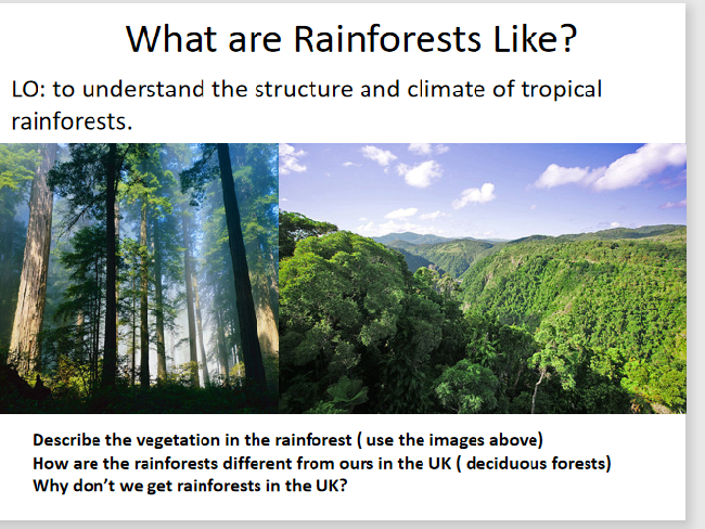
The tropical rainforest biomes are found close to the equator where low pressure systems create bands of high rainfall and long daylight hours that promote high plant growth. Rainforests are densely packed areas of tall vegeatation high amounts of life and biodiversity. This full KS3 lesson and associated sheets and activities give students a full understanding on the layers of the rainforest ecosystem structure, where they are found, and how to analyse and describe the climate of a rainforest using a climate graph. This lesson was originally designed as part of a year 7 ecosystems topic, but would work equally well for year 8. The main task involves students sketching a copy of a diagram on the layers of the rainforest and annotating it in detail using prompts and gap-fill sentences to help them. They then watch a video and make further independant labels.
Irrigation is the human process of artificially watering crops on a large scale using networks or canals ans sprinkler systems. Although irrigation can improve water availability and yield of crops in arid areas, it can also lead to contamination of local drinking water supplies which in turn creates substantial health problems.
This lesson is appropriate for self-study/ remote learning from home and is designed for the AQA GCSE Geography specification A curriculum. It has tasks with lots of prompts, a card sort with answers and a 9 mark exam practice question with a detailed PEEL structure to follow;
“(9marks) For a large scale agricultural scheme you have studied, explain how successful you think it has been in improving food supplies.”
The lesson looks at the positive and negative impact of the Rajasthan Canal in India on agriculture and the local population. Students have to evaluate whether overall they think that the canal is good or bad for the region.
The river Tees flows for 85 miles through Northern England from Cross Fell in the Pennines, to the North sea near Middlesbrough. It shows typical valley features of the long profile of a river and is an important example to study for the new AQA GCSE Geography curriculum. This 6 part storyboard activity allows students to make notes independently at key stages along the river’ journey from the BBC bitesize website amongst others. This was written for lower to middle ability students in mind to give them lots of visual references to remember key facts about the river Tees. There are 3 exam type extension questions at the bottom of the worksheet to stretch the more able students in the class. To complete the task they must show skills such as field-sketching, map reading and comprehension.
Land use refers to what is built on the land at a specific point or the way in which humans use it; for example- residential, industrial, commerce and so on. Land use patterns vary considerably between HIc’s and Lic’s and this lesson examines the Hoyt and Burgess model with a focus task on Brazil. Students must place phototgraphs around their models base on their knowlege of land use patterns. They will start with a quick recap on keywords linked to the theme of urbanisation and urban environments. Fiinally a 4 mark exam question wil test their ability to compare land use between HIc’s and LIC’s. Written for the older AQA GCSE Geography syllabus, but still relevant today.
Written for year 7, this lesson has a literacy focus and introduces students to some of the physical geography and landscape characteristics of the Tundra Biome and it’s cold environment. Students analyse the descriptive vocabulary and adjectives used to describe Svalbard, then build a bank of keywords as a class to use independently in their travel writing. The aim of the lesson is to complete an extended piece of writing to take the reader on an imaginary journey through the tundra around the archipelago of Svalbard ( travel journalism skills). There is a writing frame worksheet to support students write about the physical and human geography using the 5 senses. This differentiated lesson could easily be adapted for year 8 or 9 and gets student familiar with cold environments at GCSE geography.
This comprehensive lesson explores the concept of Urban farming, and how it improves food security in the developing city of Jakarta. Urban farming is the use of limited or marginalised city spaces ( for example roof tops) to grow a range of crops for sale in local markets or for self . This can be done by collective group efforts or individually.
Through a series of video tasks, photo analysis and problem solving, students will learn the needed facts and statistics needed for their GCSE Geography paper 2 ’ Human Exam’. This lesson fits in with the wider curriculum of the topic of the AQA spec ’ challenge of resource management '.
The main task involved writing a letter with stem prompts in the margin, to practice extended writing and literacy skills.
Understanding the speed, direction and likely paths of tropical storms is fundamental in managing risk and saving lives during these atmospheric natural hazard events. Students will combine their understanding of hurricane formation and the prevailing winds across the globe, in order to plot arrows onto a map of the Pacific Ocean. These proportional arrows will represent the wind speeds of the most powerful tropical storms in recent times. Student will be given a table to fill out, using their numeracy skills, to convert wind speed into an arrow width, before locating and drawing these onto the map. Perfect skills based revision lesson, which has detailed instructions, and also shows some of the answers. Can be done in class or independently.
This resource builds on students prior understanding of the biotic and abiotic parts of the pond ecosystem, to develop critical thinking skills or thunks. This resource present series of scenarios where man-made or natural actions cause an element of change in the pond ecosystem and food chain. Students must annotate their blank pond diagram, like the example shown, in order to likely or possible changes that happen as a direct or indirect result. This flexible activity could be done as a starter, in pairs or larger groups. Possibly as a carousel revision activity, or as a stimulus for an exam response. I would encourage students to share their annotations with the class and explain why they think these things will happen. Links with the ‘Living World’ aqa GCSE Geography specification.
This game has been adapted to encourage students to use the proper GCSE Geography language of ’ DESCRIBE’ in order to cross off landforms on the sheet such as wave cut platforms, beaches bars, tombolo’s arches and stumps. Instead of pupils asking the questions on the features of people, they ask each other questions on the features of the landforms; is it made by erosion? Is it tall or flat? Is it exposed at low tide? etc. This will encourage students to become lead learners and have dialogue about their knowlege. perfect for an easy, no plan revision or intervention schedule. The best way to play the game is to insert each coloured sheet into a clear plastic wallet and hand each student one of these and a wipeable marker pen. That way you don’t end up continually photocopying and wasting resources.
This lesson is designed to follow on from the Sumatra Earthquake case study lesson to look at how Chile’s preparation planning and protection ( 3 P’s) helped it to cope with the aftermath of the large magnitude earthquake in 2010. Students then have to plan and write a 9 mark question comparing the 2 earthquakes. A detailed help framework and model answers are provided for each level ; basic, clear and detailed.
Using a simple 3d slot- in Christmas tree template, this will keep your kS3 geography classes happy and crafting in the festive season. The Christmas tree templates have been adapted on photoshop to show a choice of 3 designs; maps of lapland, images of biomes and flags of the world. Student can also use a blank template to record and reflect on their geographical learning from accross the year. These templates could also easily be used to make geographical themed christmas bunting! Simple and easy to do, but effective and would make a lovely set of classroom displays, ideal for open evenings. These designs will work well photocopied in black and white, and students can add colour themselves to extend the activity and keep photocopying budgets down.
This full lesson combines sketching skills and reading comprehension to annotate a diagram of the different rainforest layers: forest floor, understory, canopy and emergent layer. Tropical rainforest biomes are found around 0 degrees lattitude, also known as the equator. Almost all GCSE geography examination boards expect students to have a detailed understanding on the layers and features of the rainforest. This lesson includes a kinathstectic mini-quiz to test students understading on each of the layers; they move around the 4 corners of the room to classify statements on each of the different layer characteristics.
The geology of a coastline will have an impact on how quickly it retreats backwards due to the erosion processes off hydraulic action and abrasion. This lesson considers how the aspect, rock type, layers and existing sea defenses all contribute to different rates of erosion. The meanings of the terms lithology, concordant and discordant coastlines are apparent throughout the lesson. This lesson was designed initially for an interview, and worked really well for a 50 minute lesson duration.
starter: Students examine the picture and discuss what is happening to the houses and why. They then compare two coastlines; Durdle Door and Swanage Bay, and predict which one they think will retreat the quickest, with the aid of maps.
Main - students annotate their images/ maps with information about the geology of each coastline, from either the teacher talk or print-outs from the slides. they can be encouraged to do their own research also at this point. Then they attempt a 4 mark exam question designed to test their understanding of the geology and how it influences coastal erosion.
plenary- a gap fill exercise on an image to test students recall on the main factors discussed in the lesson.
I love to spend a lesson doing these reflection activities at the end of a half term or unit of work. These are ideal for lower year groups, 7 and 8, but possibly could be used for junior years at primary school too. I set these when I want some feedback on my topic and also some time to get some assesment marking done. For those that finish early ask them to mount their sheet onto coloured sugar paper and draw a fancy border, alternatively print double-sided with a geography themed colouring page/ map on the reverse. Keep completed copies for displays and to bring out at open evenings.
This odd-one out activity encourages students to consider key terms, important concepts and processes within hot deserts and tropical rainforests. There are 8 sets of 4 words/ phrases and students must critically think about which one does not fit the overall pattern. Answers are provided with simple explanations. This works well as a starter activity for GCSE groups but could easily be set as a homework task for independant study.
This is a stand-alone activity using De Bono’s thinking skills/ hats to analysis a GIS image of air pollution levels accorss the uk.
There is a link to the met office website to help complete the task, and an extension activity for the more able. The questions are colour-coded into the 6 hats, however you don’t need any prior knowlege on these to utilize the resource. Originally written for our year 9 GIS scheme of work.