I'm a Geography teacher with experience educating at various levels, ranging from mainstream schools, SEN and extra-curricular tuition. I also have experience in teaching humanities, English and PSHE topics. My resources are designed primarily as schemes of works for mainly Geographical topics with all levels considered
I'm a Geography teacher with experience educating at various levels, ranging from mainstream schools, SEN and extra-curricular tuition. I also have experience in teaching humanities, English and PSHE topics. My resources are designed primarily as schemes of works for mainly Geographical topics with all levels considered
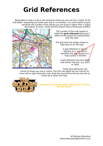
These worksheets help students to develop their undertanding of grid references and how to use them within their work and coursework with simple clear instructions and examples
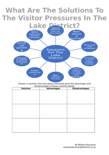
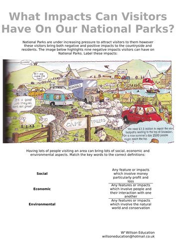
National Parks are under increasing pressure to attract visitors to them however these visitors bring both negative and positive impacts to the countryside and residents.
These worksheets look at some of the negative impacts visitors can have on National Parks and the possible solutions to these.
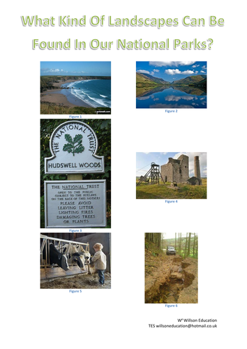
With a number of National Parks across the country it is not surprising to discover that their landscapes are varied. This worksheet looks at these landscapes and why visitors maybe attracted to these as well as what they can offer the visitors .
National Parks are under increasing pressure to attract visitors to them however these visitors bring both negative and positive impacts to the countryside and residents.
These worksheets look at some of the negative impacts visitors can have on National Parks and whether they are social, economical or environmental.
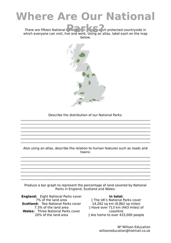
There are fifteen National Parks within Britain, each protected countryside in which everyone can visit, live and work. These worksheets look at their location, distribution and location in relation to other landmarks. Who owns the land within the National Parks is discussed, with also the opportunity to develop their graph skills.
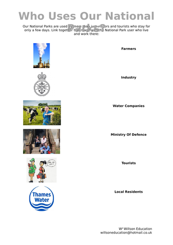
Our National Parks are used by more than visitors and tourists who stay for only a few days. These worksheets primarily at Industry, Ministry Of Defense and Water Companies, Firearms Or Ramblers, Farmers and Local Residents, their uses of the land and how this can effect the local area.
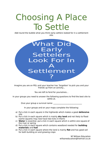
These worksheets look at the key elements of a settlement site for early man and tribes today. By working through these elements the perfect location is highlighted on the map and the students need to explain why this is the ideal place to build a settlement
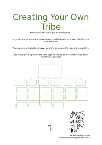
Here is a chance for your students to get a little creative. In groups they need to use information they have gathered from studying tribes to create their own. A spider diagram is provided to help them include as much information as possible
Shanty towns are found on the outskirts of many large cities especially in LEDCs. The people living here must contend with harsh environments with little access to clean water, electricity, and struggle to get jobs and capital. These worksheets look at the push and pull factors surrounding relocating, and the advantages and disadvantages of different residential locations within cities. The materials to build homes are examined alongside discussing the common issues found within shanty towns, their priorities, and the costs to moderate these to better their lives.
A range of individual and group activities are incorporated within these worksheets, including, drawing, annotating their thoughts, and ideas and developing arithmetic skills.
Please like and follow us on Facebook @WillsonEducation, Instagram @willsoneducation and Pinterest @willsoned for more exciting resources, activities, and upcoming events to incorporate into your lessons.
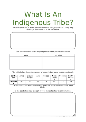
These worksheets highlight to students how many indigenous tribes can be found around the world and where. The pattern of their location and choice of environment are discussed also
About a tenth of the Earth’s population live in mountainous areas. These worksheets look at the lives of the Chagga People, Sherpa People, and Quechua Tribe.
The Chagga People live on Mount Kilimanjaro however, since the area was given National Park status in 1970, they have seen an increase in tourists which has resulted in their displacement to the dry, dusty plains below. The children are taught to love and respect the mountain through their geography lessons; although many families are unable to afford school necessities, and some don’t attend at all. Your students are tasked to choose how to spend £15,000 of aid to help double school attendance and petition the Minister Of Education.
The Sherpa People live in Nepal and have become heavily influenced by explorers hoping to conquer Mount Everest. Your students will discover the history and life of the Sherpa People and develop their views on whether they believe these influences have been positive or negative. The environmental impacts are discussed with the support of a newspaper article which explores how the Sherpa People have cleared over 6500lbs of debris left behind by explorers.
The Quechua Tribe live in the Andes Mountains where they farm vegetables and keep cattle. Your students look specifically at how the llama has adapted to life in mountainous areas and how this may evolve as the Earth’s climate changes. They also look at how the Quechua have evolved slightly larger hearts and lungs compared to themselves and how this helps them live in the high mountainous environments.
A range of individual and group activities are incorporated within these worksheets, including, gathering research from print and video, annotating their thoughts and ideas, and developing arithmetic skills.
Please like and follow us on Facebook @WillsonEducation, Instagram @willsoneducation and Pinterest @willsoned for more exciting resources, activities, and upcoming events to incorporate into your lessons.
The Pitcairn People live on the island of Pitcairn, a small landmass which together with Henderson, Ducie and Oeno, make up the Pitcairn Islands Group in the South Pacific. 250 people once inhabited this picturesque island, but this has dwindled to around 50 today, and it is predicted by 2045 only three people of working age will live on the island. The students discuss why they think the populous is leaving the island and what impacts this may have on those remaining. The students learn about the successful beekeeping and honey production on Pitcairn and examine what this could mean for the island’s future.
A range of individual and group activities are incorporated within these worksheets, including, gathering research from print and video, annotating their thoughts, and ideas and drawing and interpretating graphs.
Please like and follow us on Facebook @WillsonEducation, Instagram @willsoneducation and Pinterest @willsoned for more exciting resources, activities, and upcoming events to incorporate into your lessons.
Alongside the many animals which call the rainforest home, there are about 1.5 million people who also live there. They are able to get everything they need to survive from the forest and in return, the rainforest is treated with respect, making sure no harm comes to it.
These worksheets look at four specific tribes: The Kayapo Tribe, The Yanomami Tribe, The Matsés Tribe, and The Awá Tribe. The students learn how the Kayapo Tribe believe they came to live in the rainforest, compare their own lives to that of the tribespeople, and learn how illegal gold prospectors have threatened the tribespeople.
The lives and gender roles of the Yanomami Tribe are studied through the narrative of a ten-year-old tribe member, who explains the use of face and body paint in their culture. The Matsés Tribe is explored through its many uses of the acate green tree frog and their continuing threat from oil companies who wish to drill within their land. The Awá Tribe is investigated through a video entitled ‘The Earths Most Threatened Tribe.’
The worksheets conclude with the students being given the opportunity to study and present their findings of one of the many other tribes, up to an additional fourteen tribes, believed to be living within the Amazon Rainforest.
A range of individual and group activities are incorporated within these worksheets including: gathering research from print and video; drawing a story board; students annotating their thoughts and ideas; students comparing their own lives with others, and illustrating empathy and support.
Please like and follow us on Facebook @WillsonEducation, Instagram @willsoneducation and Pinterest @willsoned for more exciting resources, activities, and upcoming events to incorporate into your lessons.
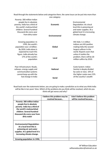
These worksheets look briefly at India in economics, environmental, global, local, national and social terms and the students discuss how they think India may develop and change over the next ten years
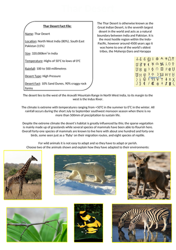
The Thar Desert is otherwise known as the Great Indian Desert, is the seventh largest desert in the world and acts as a natural boundary between India and Pakistan. It is the most hostile region within the Indo-Pacific, however around 4500 years ago it was home to one of the world’s oldest tribes, the Mohenjo Daro and Harappa.
These worksheets look at how plants and animals adapt to life in the desert with the students designing the ultimate desert animal which is then peer assessed by their classmates
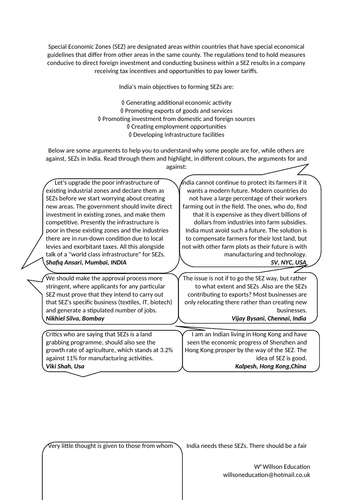
Special Economic Zones (SEZ) are designated areas within countries that have special economical guidelines that differ from other areas in the same county. The regulations tend to hold measures conducive to direct foreign investment and conducting business within a SEZ results in a company receiving tax incentives and opportunities to pay lower tariffs.
These worksheets look at India’s main objectives to forming SEZs and the arguments before and against them, with the students debating these at the conclusion.
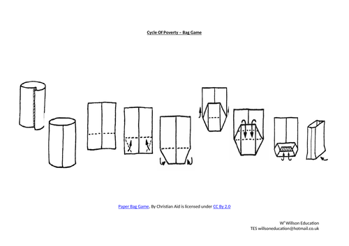
The cycle of poverty is a phenomenon where poor families, more severely in LEDCs, become trapped in poverty for generations due to limited or no access to fundamental resources such as education, financial and subsequent generations also being underprivileged.
These worksheets look at the devision of wealth within India and has the students look at life through the eyes of a poor family as to whether they should move from the country to the city, where they should move to and how to make money. One way of making money in the city is by making paper bags, they are sold to shop and stall holders who sell rice and spices. Ten bags will earn them 1 rupee (1p)! In groups they make as many bags as they can in thirty minutes…