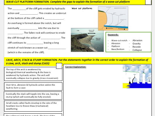
Complete lesson covering the 2023 Turkey-Syria earthquake, with a focus on the causes, impacts and factors affecting vulnerability. Lesson includes:
Do Now - locating Turkey and Syria
Short video clip
Timeline of events and student activity on Mercalli Scale and earthquake depth
Map of the tectonic boundaries and questions
Think, pair, share activity on vulnerability
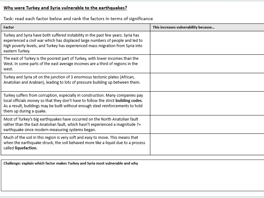
Printable worksheet on factors affecting vulnerability
Check for learning - correct the mistakes
Printable worksheet on impacts, with sorting activity and challenge questions
News article about vulnerability with questions as a challenge task
Plenary questions
Complete lesson covering all aspects of global atmospheric circulation, including circulation cells, high and low pressure and surface winds. Lesson includes:
Keyword Do Now match-up
Explanation of high and low pressure
High and low pressure activity and AfL to check understanding
Explanation of why the Equator is so hot (including diagrams and written task)
Video to summarise the circulation cells
Modelled diagram of circulation cells
Task with worksheets for circulation cells
Surface winds explained
AfL tasks and plenary to check for understanding
Complete lesson covering the 2004 Boxing Day tsunami in the Indian Ocean. Lesson includes:
Do Now
Video and questions
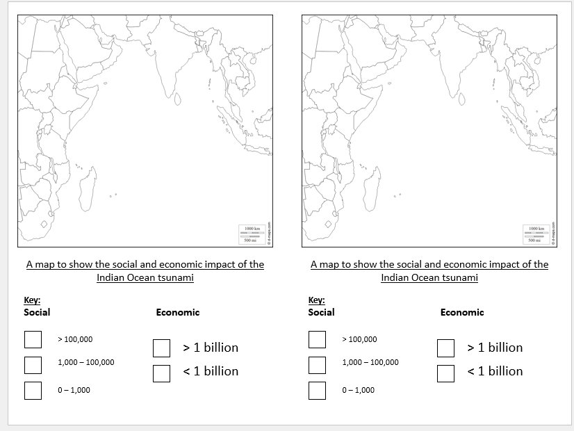
Printable maps and data to create a choropleth map to help students decide which country was worst hit
Decision making activity with 2 options to prevent future tsunamis (printable sheet)
Plenary
Complete lesson covering the Ukrainian refugee crisis. Lesson could be adapted for all key stages. Lesson includes:
Do Now
Explanation of the difference between asylum seekers & refugees
Mind map the reasons for refugees
Printable news article and questions on the causes of the conflict
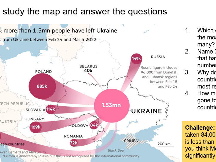
Map of refugee movements in Europe and questions
Video
Printable list of impacts on European host countries & activities
Plenary
Complete lesson covering the River Nile and a decision making activity regarding control of the Nile. Lesson was designed for KS3. Lesson includes:
Do Now
History of the Nile
Video and bingo card activity
Egypt’s population distribution
4 different viewpoints worksheet and table to complete
Complete lesson covering fracking in the UK. Designed for the Edexcel GCSE specification, but could be used with other specifications or lower year groups. Lesson includes:
Do Now - what is fracking?
Video about fracking
Graphs showing the impact of fracking in the US
Map showing where fracking could occur in the UK
AfL - correct the mistakes
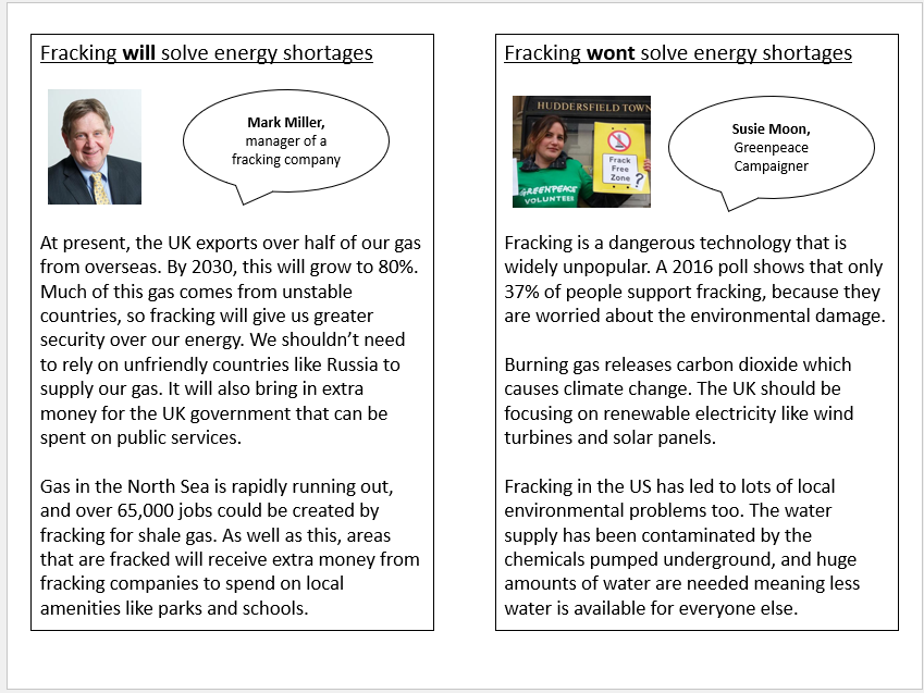
Printable information cards with differing views - students debate
Images illustrating some of the issues with fracking
3 mark exam question and model answer
Complete scheme of work covering conflict in the Middle East over 16 lessons. The first few lessons introduce the Middle East, before students focus on energy as a source of conflict and then water. Finally, students examine how religion and borders may result in conflict. Students complete a hypothesis sheet throughout the scheme of work discussing whether conflict in the Middle East is inevitable. This can be used at the end of the scheme of work in an essay or there is an optional end of topic test instead. See lessons below:
Locating the Middle East
The Geography of the Middle East
Using Google Earth to Research the Middle East
What is Conflict?
Oil Conflict in the Middle East
Oil Wealth and Development
Energy Futures
How does the Middle East’s Geography cause Conflict?
Mid-topic Writing Lesson
Water Conflict and Scarcity
Water Conflict and Climate Change
Who Should Control the River Nile? (Decision Making Activity)
Water Futures
Key Players in the Middle East
Religious Conflict
Middle East Borders
End of Topic Test (30 marks with a range of questions)
Complete lesson covering the priorities for regeneration. Lesson was designed for the Edexcel A-level but could be used with other exam specifications. This lesson focuses on 4 priorities: sink estates, gated communities, commuter villages and declining rural settlements; each is exemplified with a case study sheet. Lesson includes:
Pre-reading on each type of priority (Word doc that can be printed)
Do Now based on the pre-reading or alternative Do Now based on past content
Maps showing IMD in London & Manchester
Summary of each type of community
Information sheets for each type of community and questions/table to complete
Rural decline summary
Exam question plenary
Complete lesson covering the different ways that countries try to limit globalisation, with a focus on censorship, migration and trade protectionism. Lesson was designed for the Edexcel A-level geography Globalisation topic, but would be suitable for other specifications and schemes of work. Lesson includes:
Do Now
Shared partner work - how can countries promote or limit globalisation?
Keywords
Comprehension questions using a printable handout on ways that countries limit globalisation
AfL activity to check for understanding - could be verbal or written
Plenary - ranking activity
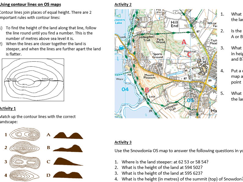
KS3 lesson covering height and contour lines. Includes:
Do Now activity
Explanation of relief and altitude
Explanation of the 3 ways of showing height on maps
Contour line explanation
Main activity worksheet
Quiz and plenary
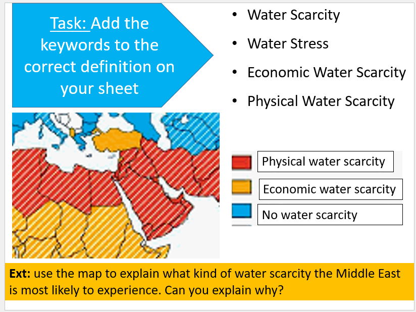
Complete lesson covering water conflict and water scarcity in the Middle East, with a focus on the Jordan River. Lesson includes:
Do Now - locating the Jordan River
Comparison of precipitation between Jordan and the UK
Keyword match-up activity and extension
Link to Water Scarcity Atlas for discussion
Video
Annotate and complete the sentences on the map of the Jordan River - printable handout
Plenary
Bonus video and questions
33 mark end of topic test for the Weather Hazards & Climate Change topic, with all questions in the format of the actual GCSE for Edexcel A. Includes a mixture of short answer questions and an 8 mark question at the end. A resource sheet that can be printed and mark scheme is also included. Ideal for use at the end of this topic.
Complete lesson covering the geography of the Middle East. Lesson includes:
Do Now - map labelling activity
Think, pair, share with key images from the Middle East
Video and questions
Labelling map task (Atlas required)
Plenary
Complete lesson covering greenfield and brownfield sites. Lesson was designed for the Edexcel A GCSE Geography Spec, but could be used with any GCSE specification or with KS3. Lesson includes:
Do Now
Partner activity to remember the definition of greenfield and brownfield
AfL activity
Definitions
Printable handout covering the pros and cons of each site; students complete a table using the information
Answers
Extended writing activity
2 mark exam question plenary
This resource contains a revision guide for Paper 1 (Physical) and Paper 2 (Human) Edexcel A GCSE Geography. Each revision guide contains knowledge organisers for each topic, along with a section on the key mathematical skills required and possible 8 mark questions students may encounter.
Also, please check out the accompanying student work booklet that they can complete using this revision guide at: https://www.tes.com/teaching-resource/geography-edexcel-a-gcse-revision-booklet-12649728
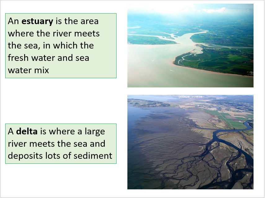
Complete lesson on deltas and estuaries. Designed for KS3 but could be used with KS4 too. Lesson includes:
Do Now
Recap on physical processes and the lower course
Definitions
Delta or estuary AfL
Diagram draw and label task
Extension reading and questions on the Nile Delta
Calculating averages exam question using river discharge
These revision booklets contains activities for pupils to complete that cover the whole of Paper 1 (Physical) and Paper 2 (Human). Goes well with the Edexcel Revision Guides that I also sell https://www.tes.com/teaching-resource/geography-edexcel-a-gcse-revision-guides-12504527
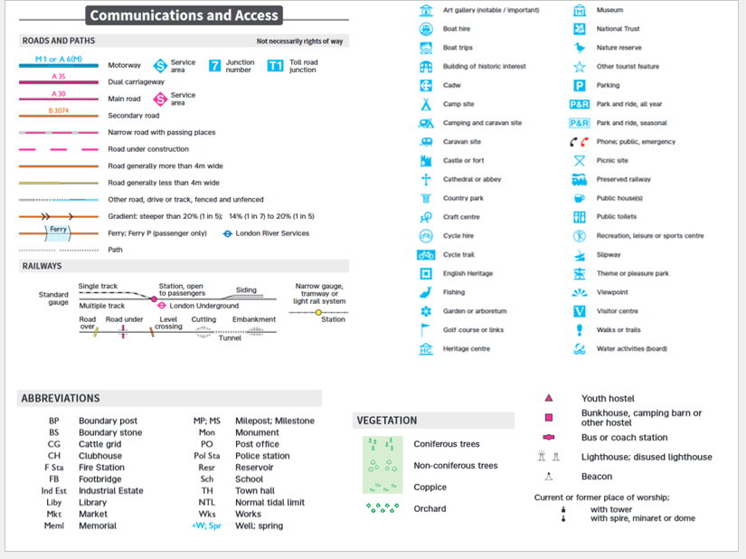
Complete lesson covering OS map symbols. Lesson includes:
Do Now labelling activity using a printable OS map
Recap on other types of maps
Labelling activity with printable OS map symbols sheet
OS map symbols bingo to check understanding
Plenary - describe a route on an OS map using the symbols
Complete lesson covering the main air masses that affect the UK. Lesson includes:
Do Now
Description of an air mass
Video
Questions using map
AfL activity
Match up the air mass with the description (printable sheet)
AfL to check understanding
Explanation of the Jet Stream
Student word fill activity to describe how the Jet Stream affects the UK’s weather
A3 sheet with detailed ideas about how to respond to the threat of earthquakes in Haiti. Students have $20 billion to spend using the costed ideas and must justify it in the boxes.