I am a Geography specialist who has also been teaching GCSE history for the past few years. I have uploaded some lessons for History and Geography. I hope people find them useful.
I am a Geography specialist who has also been teaching GCSE history for the past few years. I have uploaded some lessons for History and Geography. I hope people find them useful.
This bundle features all 6 lessons from the AQA GCSE Geography Unit 1A section on climate change. Each lesson has a variety of differentiated activities, exam questions with guidance, video clips and worksheets ready to photocopy or print.
The order of the lessons is:-
The Evidence for Climate Change
The Natural Causes of Climate Change
The Human Causes of Climate Change
The Effects of Climate Change
Managing the Impacts of Climate Change
Adapting To Climate Change
I hope this saves you valuable planning time.
https://www.tes.com/teaching-resources/shop/markthegeographer
AQA GCSE Geography lesson for the new specification Unit 2A: For this section we use London as our case study. In this lesson we introduce London, it’s location and site factors and its population.
We start with a simple quiz about London to test the pupils general knowledge of the capital.
We then look at the location of London and the pupils describe London’s location based on the C.L.O.C.K formula. But you could use any method. We then have a look at the history of London before the pupils undertake an ‘art attack’ activity where they are creating an annotated sketch map of the location of London and it’s settlement site factors. We then look at London’s population, looking at general facts, population structure and ethnicity.
We finish with a simple GCSE-style question plenary.
In a nutshell lesson includes:
Quiz on general knowledge of London.
Locating London activity
‘Art attack’ activity with guidance on producing an annotated sketch map
Video clips where appropriate
Population pyramid activity
Graph interpretation task on ethnicity in London
GCSE-style question with guidance on how to respond
Hope this saves you some valuable planning time.
https://www.tes.com/teaching-resources/shop/markthegeographer
AQA GCSE Geography lesson for the 2016 specification Unit 1C: In this lesson we look at the physical and human factors affecting flood risk and storm hydrographs and what factors affect their shape.
We start with a retrieval practice quiz with ten questions. We begin by looking at the definition of flooding and a brief example by considering the floods around Doncaster in 2019 and 2020. There is a video clip for this. We then look at the physical and human factors that affect flooding. The students have a diagram to annotate and locate an appropriate example on the diagram, they then colour code the annotations into physical and human factors. We then explore the components of a hydrograph. The students have a blank graph to label on the various component parts of the graph. We then look at what factors are likely to affect the storm hydrograph. Here the students have a grid to fill in with annotations from the board. They have to locate where the annotation would logically go on their grid. We finish with a 4-mark GCSE style question and there is some tips for students who need it on how to answer it.
Hope this saves you some valuable planning time.
https://www.tes.com/teaching-resources/shop/markthegeographer
AQA GCSE Geography lesson on the Environmental Characteristics of Hot Deserts. This is the second lesson on Hot Deserts for the AQA specification. The lesson includes:
Camel starter activity
Worksheet on plant and animal adaptations
Video clips
4-mark exam question
Plenary memory activity.
The pupils will work there way through these tasks and gain an understanding of plant and animal adaptations.
Hope this helps.
https://www.tes.com/teaching-resources/shop/markthegeographer
AQA GCSE Geography lesson from the Nigeria: A Newly Emerging Economy section. Second lesson in this unit of work. In this lesson we start by looking at the different environments in Nigeria and the pupils work to create an annotated map of the country. We then use information cards to complete a knowledge organiser. Looking at Nigeria’s social, political, cultural and environmental context the pupils fill out their organiser from the cards. We then move on to answer a GCSE style question and the pupils have some guidance on how to answer this sort of question. Included is:
All the information cards
Starter
annotated map task on Nigeria’s environments
Knowledge organiser task using info cards activity
4-mark GCSE style question with guidance.
Hope this helps.
https://www.tes.com/teaching-resources/shop/markthegeographer
AQA GCSE Geography lesson for Unit 2C: The Challenge of Resource Management. The lesson is roughly one hour long, but is easily extended. We start with a quiz starter to get the pupils thinking about our food imports. We then look at how much of our food is imported and why that is the case. We consider then what challenges that creates for the UK. We then complete a skills task looking at high-value mangetout peas from Kenya. The pupils create a divided bar chart and answer related questions. We then finish by looking at ways the UK has tried to meet the challenge of increased food demand using agribusiness and organic farms. The pupils use this information to tackle a GCSE-style question. Included is:
Starter quiz
Hexagon task exploring what factors have led to UK reliance on imports
Data presentation skills task using mangetout peas example from Kenya
GCSE style question
Hope this helps.
https://www.tes.com/teaching-resources/shop/markthegeographer
AQA GCSE Geography lesson for the new specification Unit 1A: In this second lesson in the section we look at the natural causes of climate change.
We start with a quick knowledge check on climate change with a quiz.
We then look at orbital changes, sunspot activity and volcanic eruptions as mechanisms for causing climate change. The pupils will have a worksheet to fill in and there are information sheets for each mechanism. This could be done as a round the room activity or group work, it’s up to you. We use Tambora as an example of volcanic activity affecting climate.
We finish with GCSE-style question with some suggested content if they need help.
In a nutshell lesson includes:
Climate change quiz starter
Worksheet activity on mechanisms for natural climate change
Video clips where appropriate
GCSE-style question with guidance on suggested content.
Hope this saves you some valuable planning time.
https://www.tes.com/teaching-resources/shop/markthegeographer
AQA GCSE Geography lesson for the new specification, Unit 2c. The lesson starts with a retrieval practice quiz from the unit. We then locate where the Wakel Basin in Rajasthan is. The pupils then annotate a photograph to explore the issues are around the supply of water to the region. We then look at the Wakel River Basin Project. The pupils use a sheet to read the extract and complete the questions on the project, then they create diagrams and pictures of the water harvesting methods and the pats scheme. We finish with a GCSE-style question with some guidance on how to answer.
In a nutshell the lesson includes:
Retrieval practice starter
Map and photo annotation tasks
Work sheet with questions and diagrams to draw
GCSE style question with a writing frame if needed.
Hope this helps save you valuable planning time.
https://www.tes.com/teaching-resources/shop/markthegeographer
AQA GCSE Geography lesson for Unit 1 A. Comparing the responses of the Chile 2010 and Nepal 2015 earthquakes. In this lesson we start with a retrieval practice grid which you can populate with your own questions. We then look at the difference between immediate and long-term responses. The pupils complete a photo interpretation task around the searching of buildings before completing a worksheet on the responses to the two earthquakes and answer some questions on what they have found. We then use the worksheets to answer a GCSE-style 9 mark question. using a structure guidance sheet together with mark scheme for content and SPAG.
In a nutshell lesson includes:
Retrieval practice starter
Photo interpretation task
Responses worksheet with questions
GCSE 9 mark question with guidance and mark scheme
Hope this saves you valuable planning time.
https://www.tes.com/teaching-resources/shop/markthegeographer
AQA GCSE Geography lesson for the new specification Unit 1C: In this lesson we look at erosional features found on a headland, wave-cut notches and platforms, caves, stacks, stumps and arches.
We start with a simple retrieval practice grid which is good for spaced practice.
We then introduce wave-cut notches and platform. After discussion about how they may have formed the pupils use an outline diagram to add annotations and explanations. We then look at the formation of caves, arches, stacks and stumps. We watch a video clip before the pupils get to teach each other and the class about the features. The pupils then get given a drawing of Durdle Door. On the picture of Durdle Door in the present, the pupils annotate the diagram. The other two diagrams are for the pupils to trace around. The idea is that the pupils will predict what Durdle Door will look like in 400 and 800 years into the future and sketch how the headland might have been affected by erosion.
We finish with a GCSE-style question on wave-cut platforms with some guidance on how to write their answer.
In a nutshell lesson includes:
Retrieval practice starter
Wave-cut platforms diagram.
Video clips where appropriate.
Durdle Door: Present and Future activity.
4 mark GCSE-style question with guidance should the pupils need it.
Hope this saves you some valuable planning time.
https://www.tes.com/teaching-resources/shop/markthegeographer
AQA GCSEGeography Lesson for Unit1A. In this lesson we look at the four different types of plate boundaries; destructive, constructive, collision and conservative (transform). We start by looking at the example of Iceland. We then use information cards to complete a foldables exercise for each plate type for the pupils to stick into their books. We then answer a GCSE-style question with some pointers on content for the pupils to use if you wish them to. ****Please note the foldables template may need adapting for certain printers as it depends on settings, it just needs a quick check to ensure it will print the right way around.
Hope this saves you valuable planning time.
https://www.tes.com/teaching-resources/shop/markthegeographer
AQA GCSE Geography Lesson for the new specification Unit1A.
The lesson requires the blue Oxford AQA GCSE textbook for the new specification
We start with a retrieval practice starter with the pupils categorising terms into the correct plate margins. The pupils then, after a brief photo interpretation Q&A activity complete a worksheet that is broken down into monitoring, prediction, protection and planning. The information is all obtained from the Oxford AQA GCSE textbook for the new specification. We then finish the lesson with a GCSE practice question with guidance for the pupils if needed.
Hope this saves you some valuable planning time.
https://www.tes.com/teaching-resources/shop/markthegeographer
AQA GCSE Geography lesson for the new specification Unit 1C: In this lesson we look at the processes of erosion and transportation (Note we don’t do longshore drift until the next lesson, too much for one lesson!)
We start with a retrieval practice grid from the previous lesson (good for spaced practice).
We then introduce the concept of erosion, we watch a short video clip of he problems at Dawlish several years ago to get the pupils thinking about why erosion is important. We then look at erosion first, the pupils have a worksheet which shows the processes. They need to describe the process, locate the process on the map with an arrow and as a bonus they get to colour the diagram in (They still love doing this in year 11). We briefly look at the four processes of transportation and they do the same thing on the diagram.
Next we explore what factors might affect the rate of these processes occurring. I get the pupils to do a spray diagram or spider diagram. The pupils then use this to answer the question on the worksheet.
In a nutshell lesson includes:
Retrieval practice starter
Worksheet on the processes of erosion and transportation.
Activity on factors influencing these processes
Video clips where appropriate
GCSE-style question with guidance on answering
Hope this saves you some valuable planning time.
https://www.tes.com/teaching-resources/shop/markthegeographer
AQA GCSE Geography lesson as part of the Nigeria: A Newly Emerging Economy unit. The lesson is roughly one hour long but can be shortened or extended. In this lesson we introduce the concept of a TNC. We then do a quick activity on the incentives for TNC’s to locate their operations in different countries. The pupils then complete a sorting exercise on the problems and benefits of TNC’s in general before we look at Shell’s operations in the Niger Delta. The pupils create a visual chart to show the overall benefits and costs, but also the extent to which those factors are benefits or costs. We then go on to answer a 6 mark question with a structure strip for support. Included is:
Starter on TNC’s in Nigeria
Exercise on incentives for TNC’s in countries
Sorting activity on costs and benefits
Costs and benefits chart on Shell Oil
GCSE style question with structure strip
Hope this helps.
https://www.tes.com/teaching-resources/shop/markthegeographer
AQA GCSE Geography Lesson for the Nigeria: A Newly Emerging Economy unit. The lesson is at lest one hour long, but is easily extended into two lessons. The lesson begins with a photo interpretation starter to introduce the pupils to some of the poverty in Nigeria. We then look at two families in Nigeria, the pupils investigate their living conditions and access to safe water, sanitation and electricity before deciding if the family would benefit from aid and if they represent the majority of Nigerian families. We the look at the benefits of International Aid and the reaons why aid may not be used effectively. We use a GCSE-style question to investigate the latter. Included in the lesson is:
Photo interpretation starter
Families task: comparing living standards (how will aid benefit them?)
Hexagon factor task explaining how aid benefits Nigeria.
GCSE style question on how aid might not be used effectively.
Hope this helps.
https://www.tes.com/teaching-resources/shop/markthegeographer
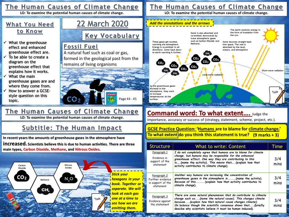
AQA GCSE Geography lesson for the new specification Unit 1A: In this third lesson in the section we look at the possible human causes of climate change.
We start with a simple retrieval practice grid based on previous learning.
We then look at what the scientist think and how a consensus has grown about the impact of anthropogenic influences on the climate and we watch a clip that summarises this. We then create a diagram in our books and the students are guided step by step through the greenhouse effect, creating the diagram as they go. The pupils then watch video clips on the three main greenhouse gases, carbon dioxide, methane and nitrous oxides. The pupils make notes around their hexagons using the video clips to help. We finish by looking at the ‘enhanced greenhouse effect’ and a 9-mark gcse-style question with guidance on how to answer for the pupils.
We finish the lesson with a GCSE-style question post-it plenary.
In a nutshell lesson includes:
Retrieval practice starter
Greenhouse effect diagram.
Hexagon task on the main greenhouse gases
Video clips where appropriate
GCSE-style question.
Hope this saves you some valuable planning time.
https://www.tes.com/teaching-resources/shop/markthegeographer
Requires the blue AQA GCSE Geography Oxford textbook
AQA GCSE Geography lesson for Unit 1A. In this lesson we compare the Chilean earthquake of 2010 with the Nepalese earthquake of 2015. The lesson includes and photo interpretation starter and video clips where appropriate. the main body of the lesson is used by the pupils to fill out their differentiated worksheets on each earthquake. We then answer a GCSE-style question using a worksheet to help the pupils learn how to structure their answers.
I hope this saves you valuable planning time.
https://www.tes.com/teaching-resources/shop/markthegeographer
AQA GCSE Geography lesson for the new specification Unit 2A: In this lesson we look at squatter settlements in Lagos, in particular Makoko.
We start with a photo interpretation stater where students can create their own questions and answer them based on a series of command words…
We then look at the location of squatter settlements in Lagos The pupils are given a map of lagos and the six figure grid references for the squatter settlements to plot on the map, we then consider why they are located where they are. The pupils then look at some statistics for Makoko and annotate the table to suggest problems that residents of Makoko face, they also create a field sketch with some annotations on.
We finish with GCSE-style questions on a squatter settlement with some guidance on how they should answer the question.
In a nutshell lesson includes:
Photo interpretation starter
Plotting squatter settlements activity
Table annotation task
Drawing from a photograph task
Video clips where appropriate
GCSE-style question with guidance on how to respond.
Hope this saves you some valuable planning time.
https://www.tes.com/teaching-resources/shop/markthegeographer
AQA GCSE Geography lesson for The Changing Economic World section. Lesson one in the Nigeria SOW. The lesson is over one hour long, but can be adapted.
We first look at the location of Nigeria and pupils complete some skills work around describing the location. We then continue to examine Nigeria’s global importance whilst the pupils complete an knowledge organiser. Then using demographic data the pupils examine Nigeria’s population whilst practicing some graphical skills. We then look at the importance of Nigeria in Africa. Included in the lesson is:
Differentiated activity on Nigeria’s Location
Knowledge organiser on Nigeria’s global importance
Graph skills worksheet on Nigeria’s Demographics
Activity on Nigeria’s importance in Africa.
Hope this helps.
https://www.tes.com/teaching-resources/shop/markthegeographer
AQA GCSE Geography Lesson from the Nigeria: a Newly-Emerging Economy section. The lesson is roughly an hour long. We start with a photo showing an illegal crude oil refinery in Nigeria and discuss what this reveals about he country and its natural resources. We then look at Nigeria’s political links to other organisations such as OPEC and the United Nations. We ask which of these are most significant to Nigeria’s development. We then look at Nigeria’s two main exports sectors, crude oil and agriculture where the students annotate a text extract to show their understanding. We then look at where Nigeria’s exports of crude oil go to by creating a flow line map. We then answer a GCSE style question worth 6 marks with guidance should the students need it. Included is:
Photo interpretation starter on illegal crude oil refinery
Sorting activity on political links
Text extract annotation task on crude oil and agriculture
FLow line map activity
6 mark GCSE stye question with guidance.
Hope this helps.
https://www.tes.com/teaching-resources/shop/markthegeographer