31Uploads
80k+Views
41k+Downloads
Geography

Lesson 4 - South Sudan Case Study (OCR Powers and Borders)
Lesson 4 of Powers and Borders for OCR A Level geography

Lesson 1 - Sovereignty and territorial Integrity (OCR Powers and Borders)
For OCR A Level Option D - Powers and Borders (post-2016 spec)
Lesson 1 meeting the LOs:
1.a. The world political map of sovereign nation-states is dynamic.
-To understand what state, nation, sovereignty and territorial integrity are and how they are fundamental in understanding the world political map.
-To understand the terms norms, intervention and geopolitics and how they are fundamental in appreciating that sovereignty and territorial integrity are complex issues.
Images and table from textbook used under Fair Use
One table from a freely shared schoology resource (author contact me if you want it removed).

Structure Strip (editable) for exam questions
A structure strip (set up for an 8 mark economic development question but could be easily changed). Students stick it at the side of their work and use it as a prompt for paragraphs.

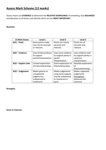
Assess Generic Mark Scheme for Edexcel A Level Geography (2016)
A generic mark scheme for the 12 mark assess questions in the new Edexcel A Level.
Can be used for planning and feedback as well.

The Challange of Global Health
A powerpoint and adapted resources to accompany the lesson on Global Health produced by the RGS for 21st Century Challenges (https://21stcenturychallenges.org/). The lesson is the work of the RGS I have just put it together on a powerpoint for easy class use - all resources are credited to their original source.
Perfect for KS5 or high-ability KS4 geography classes or for use in cross-curricular lessons. Should take an hours lesson. Includes opportunity for self/peer assessment and exam practice for AfL (assessment for learning).
Perfect for the new 2016 onwards A Level spec.
Students taken through why health is of global concern and how geography affects it.
Included: one powerpoint, a keyword activity sheet, information on Malaria and the original 21st century challenge resource sheet.

Edexcel AS / A Level Geography - Topic 3 Globalisation Revision Guide / Knowledge Organiser
A knowledge organiser / revision guide put together from my power points and worksheets on the new Globalisation topic for the new 2016 Edexcel geography AS / A Level.
Half of it is keywords and ideas with definitions and examples. The 2nd half is more detail on key topics and case study notes.

Lesson 3 - Global Governance OCR Powers and Borders A Level
Lesson 3 for OCR Powers and Borders unit
A Level Geography

KS3 Weather Knowledge Organiser
Help students revise by giving them this knowledge organiser with the key knowledge for KS3 Weather.

Demographic variations between and within settlements Lesson - Edexcel 9GE0 2016 - Diverse Places
This is a complete lesson for Topic 4B (Diverse Places) for the new A Level / AS Level Edexcel 9GE0 for teaching from 2016.
This lesson meets the learning objective:
There can be considerable variation in population characteristics (gender and ethnicity), both in and between settlements.
and covers using GIS and databases (Census) as skills.
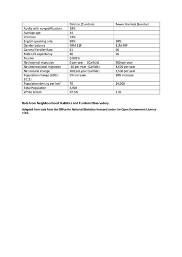
Students use GIS and databases to find out about two contrasting places, they then summarise their findings and suggest reasons for the variations. They then do a similar task for two contrasting areas in the same city.
The lesson is fully resourced and the powerpoint provides step-by-step instructions plus a video to show how to get the census data. Students will require ICT access.
While it is designed to meet the specification for 4B.1 and 4B.2 of Diverse Places 'Population structure varies form place to place and over time' in the New 2016+ Edexcel A Level / AS Level (09GE0). It will no doubt meet the requirements for other A Level specifications such as AQA and OCR due to the overlap of prescribed content please check your chosen specification.
Includes: 1 .ppt and 1 word document
Note: the font on preview is different to the font used.
All images/data are copyright of their original owners and are used under Creative Commons License and attributed where required.
Please do not remove my name from materials or upload to other sites. I have worked hard in my spare time to produce these materials.

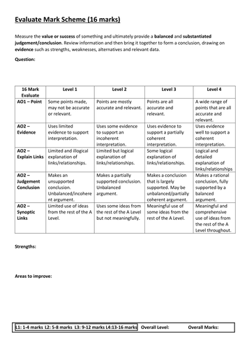
Evaluate Generic Mark Scheme for Edexcel A Level Geography (2016)
A generic mark scheme for the 16 mark evaluate questions in the new Edexcel AS / A Level.
Can be used for planning and feedback as well.

Geography Levels for New GCSE (9-1)
Struggling to implement life after levels? Well look no further.
Posters to display in classrooms to show my interpretation the new GCSE grades for the 2016 Geography Specification (9-1). These are designed to be used on any kind of assessment and are perfect to use for Assessment for Learning (AfL) through KS3 and KS4.
The levels focus on command words and build upon the old level system. The new Grade 9 is comparable to what is expected in Year 12 in the new A Level system. There are descriptors for the key level points - 2,4,5,7,9.
Includes 1 .pdf file that can be printed out and laminated. Note: The font in TES preview is different to the one on the .pdf
Please do not remove my name from the resource. I've worked hard in my own time to develop this.
**If you like this you might also like: https://www.tes.com/teaching-resource/new-geography-gcse-9-1-descriptors-ks3-ks4-11283443 **

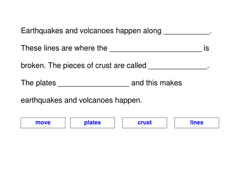
IWB Drag and Drop Cloze Plenary - Where do earthquakes and volcanoes happen?
Quick plenary activity which requires students to use an IWB to drag and drop the correct words into a cloze activity on where volcanoes and earthquakes occur. Could also be used as a worksheet.
Includes: 1 word document.
Please respect my copyright. I've worked hard in my own time to develop this.

Lesson 2 - Erosion of Sovereignty (OCR Powers and Borders)
For OCR A Level Option D - Powers and Borders (post-2016 spec) but would work for Superpowers in Edexcel.
This will take 2-3 hrs depending on class.
Lesson 2 meeting the LOs:
2.1. A multitude of factors pose challenges to sovereignty and territorial integrity.
• To understand that factors such as current political boundaries, TNCs, supranational institutions and political dominance of ethnic groups can cause erosion of sovereignty and the loss of territorial integrity.
• Case study of one country in which sovereignty has been challenged including: cause and challenges to the government and impacts on people and place.
Images used under Fair Use. Videos had to be removed due to being too big to upload - alternatives are easily available on YouTube.

Definition Dominoes - State, Nation, Sovereignty
Definition dominoes game where students have to match up keywords and their definitions.
Based on L1 (Key idea 1a) of the OCR A Level Powers and Borders spec but would fit with Superpowers type units from the other boards as well.

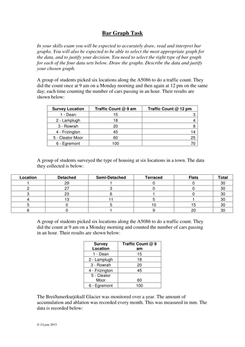
Geography Skills - Bar and Line Graphs (GCSE/A Level/AS Level New Spec 2016+)
Worksheet on drawing line and bar graphs using examples. Students are given data, have to choose the right type of graph (e.g. compound, comparative etc.), draw the graph, describe the data and justify the use of their chosen graph. Originally for AS and A Level Geography but will meet requirements for the New Spec (9-1) GCSE as well as the 2016 New Spec A Level courses given the emphasis on justify the type of presentation used. Could also be used with high ability KS3 classes and in other subjects.
Perfect either as an activity during first teaching or as a revision task. Most classes take around 45 mins to do either section (bar or line).
Included are a .pdf of the task
Please do not remove my name from these resources. I have worked hard in my own time to produce them.

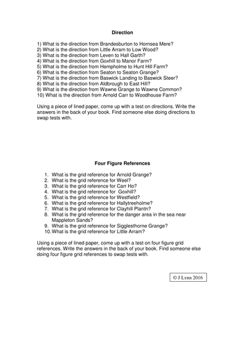
Mapskills Activity - direction, 4- & 6- figure, straight line & non-straight line distance & height.
This is an activity I have used successfully for many years. It includes 10 questions on each of the following topics:
- Direction
- 4 Figure Grid References
- 6 Figure Grid References
- Straight Line Distances
- Non-straight Line Distances
- Height
Students answer these questions using the Hornsea 1:50,000 OS Map.
*OS map is not included but most departments will have copies as it has been an exam insert in the past*
Perfect for a carousel activity when used for revision or after an assessment as students can work on an area they need to develop.
Included are a .pdf of the questions and a .pdf of the answers.
Please do not remove my name from these resources. I have worked hard in my own time to produce them.

Earthquake Assessment Task and Rubric for KS4 / GCSE (9-1)
An assessment task to design a textbook page(s) on Earthquakes complete with detailed instructions and a rubric in 'pupil-speak' covering the new 2016+ GCSE (9-1) levels as described in https://www.tes.com/teaching-resource/new-geography-gcse-9-1-descriptors-ks3-ks4-11283443
Meets spec. requirements for most exam boards.
Can be used as a AfL (assessment for learning) task, end of unit assessment or a homework project. Will take a minimum of two hours to complete for most students.
Includes a .pdf of the sheet.

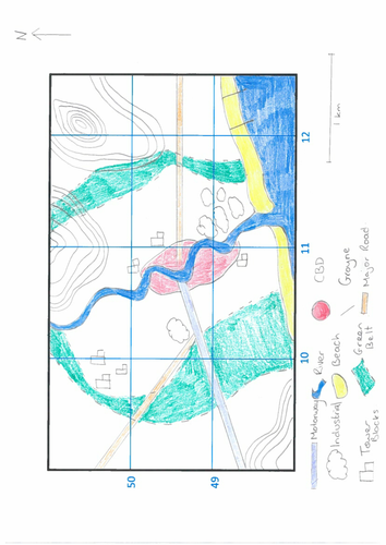
Factors affecting population density - Mapping Task for New 2016+ A Level (Edexcel 9GE0 - Topic 4b)
Students are given a base map and a series of tasks relating to identifying areas of high, average and low population density as well as wealthy/poor areas. Students then have to use their knowledge to justify their choices.
This is an activity allows students to link content to skills and apply their knowledge.
Students will have learnt about factors affecting population structure and density prior to carrying out the task.
Designed to meet the specification for 4B.1 of Diverse Places 'Population structure varies form place to place and over time' in the New 2016+ Edexcel A Level / AS Level (09GE0). It will no doubt meet the requirements for other A Level specifications such as AQA and OCR due to the overlap of prescribed content.
Included: 1 .pdf hand drawn map and 1 .pdf task sheet.
Please do not remove my name from materials or upload to other sites. I have worked hard in my spare time to produce these materials.

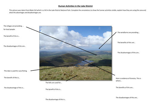
Human activities in the Lake District - Annotation task / worksheet
Give your students an opportunity to practice their annotation skills with this resource that uses a photo of the western Lake District as the basis for annotation of human activities and their advantages/disadvantages in national parks and the wider countryside.
Can be used throughout KS2-5 with differing levels of teacher support given. There are two versions of the sheet included in the download - one suitable for KS2-3 and low ability KS4 and one suitable for high ability KS3 and KS4/5.
Fits with topics included in most KS3 SoW (conservation, tourism, national parks, industry), the old GCSE (esp. for AQA tourism), the New GCSE (9-1) (glacial landscapes in the UK, changing economic world, challenge of resource management for AQA but as theses are common topics will apply to other boards).
Included: 1 .pdf A3 annotation sheet without prompts and 1 .pdf A3 annotation sheet with prompts.
Please do not remove my name from the resource. I've worked hard in my own time to develop this.

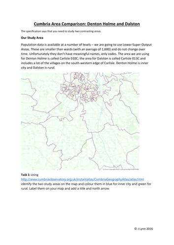
Contrasting Areas Study: Virtual fieldwork booklet
This booklet contains step-by-step instructions and activities to complete a virtual investigation into two contrasting areas of Cumbria using Census data.
Students can follow this independently as long as they have access to ICT or you could provide the data for them as part of a lesson.
Originally designed for the legacy AQA A Level specification it has been updated to fit with the local area study as part of the new 2016+ Edexcel A Level for Diverse Places. It will also meet some of the requirements for:
- Edexcel A Level Geography 9GE0 - Diverse Places and Regeneration
- Edexcel AS Geography 08GE0 - Diverse Places and Regeneration
- AQA A Level Geography 7037 - Changing Places and Place Study
- AQA AS Geography 7076 - Changing Places and Place Study
- OCR
- WJEC
The booklet also covers key skills included in the new specs including 'big data', GIS, Census data, ICT and databases.
Includes: 1 booklet in .pdf format
If you like this take a look at https://www.tes.com/teaching-resource/river-fieldwork-investigation-booklet-a-as-level-all-specs-11301334
Note: the font on preview is different to the font used.
Please do not remove my name from materials or upload to other sites. I have worked hard in my spare time to produce these materials.


