31Uploads
80k+Views
41k+Downloads
All resources

Spearman's Rank Coefficient - Worksheet
Using an A Level Geography example of Remittances versus HDI this worksheet takes students through the process of working out Spearman’s Rank in a structured way.
The answers are included.

LA Wildfires 2025
Geography in the News - LA Wildfires 2025
Simple two sided worksheet with a range of gap fill, short answers and longer answer questions based on the BBC News article on the LA Wildfires in January 2025.
Great as a simple homework or research task for KS3 or KS4 (due to open ended explain questions).
SImple language used to ensure it is accessible.
The original article the worksheet is based on is included for reference.

A Level OCR Geography - Changing Spaces, Making Places Glossary
A glossary list that can be used with A Level OCR Geography students for the Changing Spaces, Making Places topic.

Lesson 4 - South Sudan Case Study (OCR Powers and Borders)
Lesson 4 of Powers and Borders for OCR A Level geography

Lesson 3 - Global Governance OCR Powers and Borders A Level
Lesson 3 for OCR Powers and Borders unit
A Level Geography

Lesson 2 - Erosion of Sovereignty (OCR Powers and Borders)
For OCR A Level Option D - Powers and Borders (post-2016 spec) but would work for Superpowers in Edexcel.
This will take 2-3 hrs depending on class.
Lesson 2 meeting the LOs:
2.1. A multitude of factors pose challenges to sovereignty and territorial integrity.
• To understand that factors such as current political boundaries, TNCs, supranational institutions and political dominance of ethnic groups can cause erosion of sovereignty and the loss of territorial integrity.
• Case study of one country in which sovereignty has been challenged including: cause and challenges to the government and impacts on people and place.
Images used under Fair Use. Videos had to be removed due to being too big to upload - alternatives are easily available on YouTube.

Definition Dominoes - State, Nation, Sovereignty
Definition dominoes game where students have to match up keywords and their definitions.
Based on L1 (Key idea 1a) of the OCR A Level Powers and Borders spec but would fit with Superpowers type units from the other boards as well.

Lesson 1 - Sovereignty and territorial Integrity (OCR Powers and Borders)
For OCR A Level Option D - Powers and Borders (post-2016 spec)
Lesson 1 meeting the LOs:
1.a. The world political map of sovereign nation-states is dynamic.
-To understand what state, nation, sovereignty and territorial integrity are and how they are fundamental in understanding the world political map.
-To understand the terms norms, intervention and geopolitics and how they are fundamental in appreciating that sovereignty and territorial integrity are complex issues.
Images and table from textbook used under Fair Use
One table from a freely shared schoology resource (author contact me if you want it removed).

KS3 Weather Knowledge Organiser
Help students revise by giving them this knowledge organiser with the key knowledge for KS3 Weather.

Structure Strip (editable) for exam questions
A structure strip (set up for an 8 mark economic development question but could be easily changed). Students stick it at the side of their work and use it as a prompt for paragraphs.

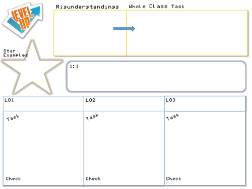
Level Up Planning Sheet
In the style of the '5 minute lesson plan' this is a planning sheet for feedback/DIRT lessons.
Especially useful for those following a 4:2 teaching plan, there is space to consider misconceptions from marking, whole class DIRT tasks to improve work and challenge misconceptions, three areas to plan for group work to address specific areas students need to work on to master topics, an area for any 1:1 notes needed and a space for star examples that you can share with the rest of the class to demonstrate good practice.

Blockbusters Population Revision Game
A printable revision game in the style of the TV show Blockbusters.
Students play in pairs to make a line across the board; they make the line by answering keyword questions.
The questions are based on the AQA A GCSE Geography topic of Population Change but are applicable to most Population topics especially the AQA Legacy AS spec.

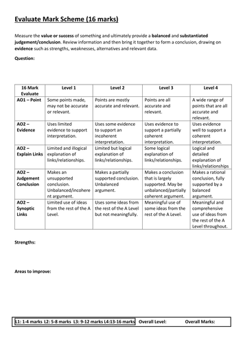
Evaluate Generic Mark Scheme for Edexcel A Level Geography (2016)
A generic mark scheme for the 16 mark evaluate questions in the new Edexcel AS / A Level.
Can be used for planning and feedback as well.

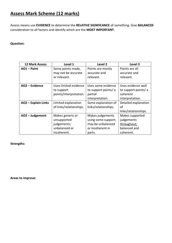
Assess Generic Mark Scheme for Edexcel A Level Geography (2016)
A generic mark scheme for the 12 mark assess questions in the new Edexcel A Level.
Can be used for planning and feedback as well.

Edexcel AS / A Level Geography - Topic 3 Globalisation Revision Guide / Knowledge Organiser
A knowledge organiser / revision guide put together from my power points and worksheets on the new Globalisation topic for the new 2016 Edexcel geography AS / A Level.
Half of it is keywords and ideas with definitions and examples. The 2nd half is more detail on key topics and case study notes.

Data Driven 9-1 Seating Plan
After struggling to find a flexible seating plan that did what I needed it to do I created this. You can use 9-1 grades for the New GCSE.
Simply copy and paste the 'seat' in the top-left hand corner onto the spreadsheet to create the layout of your classroom.
On the data input sheet copy or type your data - it is currently set up to show name, target, current grade, PP, SEN, HP (health plan), and above, on or below target. All but target, current grade and AOB can be changed to show any other data without messing up the formatting. If you unhide a row on the seating plan you can also type text based information in the info section for example groups, access arrangements etc.
On the seating plan just change the top left number on each seat to match that student on the data sheet e.g. 1 will look up student 1, 2 will look up student 2. The information will be shown on the seating plan with colour coding for on, above, below target, SEN and PP.
It all uses very simple Excel formulas so easy to change to meet your needs.

Mann-Whitney U Test
A power point showing how and when to use the Mann-Whitney U statistical test and an worksheet guiding the students though calculating it using a geographical example. Includes teacher answer sheet.
Great for teaching both old and New (2016) specification A level or AS level geography - designed for Edexcel but matches requirements of other specs such as AQA.
Can also be used as an introduction to the test for biology, maths, psychology lessons etc.

16-Point Compass Directions and Distance / Scale Worksheet
Worksheet to practice 16-point compass directions and straight line distance using a simple scale.

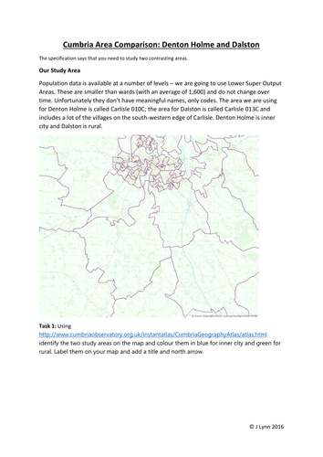
Contrasting Areas Study: Virtual fieldwork booklet
This booklet contains step-by-step instructions and activities to complete a virtual investigation into two contrasting areas of Cumbria using Census data.
Students can follow this independently as long as they have access to ICT or you could provide the data for them as part of a lesson.
Originally designed for the legacy AQA A Level specification it has been updated to fit with the local area study as part of the new 2016+ Edexcel A Level for Diverse Places. It will also meet some of the requirements for:
- Edexcel A Level Geography 9GE0 - Diverse Places and Regeneration
- Edexcel AS Geography 08GE0 - Diverse Places and Regeneration
- AQA A Level Geography 7037 - Changing Places and Place Study
- AQA AS Geography 7076 - Changing Places and Place Study
- OCR
- WJEC
The booklet also covers key skills included in the new specs including 'big data', GIS, Census data, ICT and databases.
Includes: 1 booklet in .pdf format
If you like this take a look at https://www.tes.com/teaching-resource/river-fieldwork-investigation-booklet-a-as-level-all-specs-11301334
Note: the font on preview is different to the font used.
Please do not remove my name from materials or upload to other sites. I have worked hard in my spare time to produce these materials.

River Fieldwork Investigation Booklet - A / AS Level - All specs
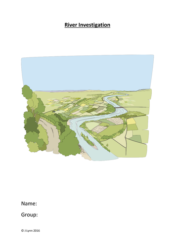
A complete, step by step work booklet for students doing a river investigation. Students can independently work through the booklet on their own or you can use it as part of fieldwork lessons.
This investigation is based on the aim to investigate changes downstream in a river and otherwise is generic to fit with your fieldwork.
Covers: describing the study area using an OS map, justifying the choice of location, justifying hypothesis and linking to model, primary/secondary data, methodology (separate table provided), risk assessment, describing each site, results, Spearman's Rank Correlation (bedload size vs velocity), conclusion, evaluation.
Perfect for preparing students for their fieldwork skills exam or as a mock for the independent investigation.
Suitable for the following popular new specs from 2016+ as well as the AQA legacy specification:
- Edexcel A Level Geography 9GE0
- Edexcel AS Geography 08GE0
- AQA A Level Geography 7037
- AQA AS Geography 7076
- OCR
- WJEC
Includes: 1 booklet in .pdf format and a methodology table in .pdf format.
If you like this take a look at : https://www.tes.com/teaching-resource/contrasting-areas-study-virtual-fieldwork-booklet-11301427
Note: the font on preview is different to the font used.
Please do not remove my name from materials or upload to other sites. I have worked hard in my spare time to produce these materials.


