Thank you for visiting! Here you will find a selection of printable, interactive worksheets for your classroom: Basic Geography worksheets with simple maps, ESL, Spanish, Bible, Reading Comprehension and more. I hope you find the resources useful! Reviews are welcome and very much appreciated. Thank you so much.
Thank you for visiting! Here you will find a selection of printable, interactive worksheets for your classroom: Basic Geography worksheets with simple maps, ESL, Spanish, Bible, Reading Comprehension and more. I hope you find the resources useful! Reviews are welcome and very much appreciated. Thank you so much.
Introduce your students to El Salvador with two printable worksheets (plus answer key). Your students will read a brief introduction to El Salvador (location, capital, flag, language), write 'San Salvador' next to the star on the map to show the capital, color the small map and flag, and use the map and compass to answer 7 questions on page 2. Colored pencils and a pen or pencil needed for this activity. No other prep needed. Basic Geography worksheet with a simple map to introduce El Salvador and practice cardinal and ordinal directions.
For use with Interactive Notebooks: After the worksheets are completed, students can cut out the map and flag and paste into the notebook under the topic of Central America (or Spanish-Speaking Countries)/Sub-topic: El Salvador. Under the map and flag, students can write a summary in their own words about what they now know about this country. Collect worksheets for other countries of Central America (or Spanish-speaking countries) to add to the notebook! All available in this store! Please browse this store for a selection of worksheets for countries of Central America (and beyond!).
Thank you so much for using my Geography worksheets in your classroom! I hope you find them useful. Reviews are welcome and very much appreciated!
Printable Handout (1 page plus answer key) ‘A Summer Day at the Beach.’ Students will fill in the blanks using the word bank of past-tense verbs: parked, swam, collected, drove, decided, watched, walked, sat, read, ate, packed, carried.
Cloze activity for ESL, EFL, ELL, ESOL. Vocabulary building, Reading Comprehension, Grammar.
Introduce your learners to RUSSIA with this printable handout of two worksheets (plus answer key). Your students will read a brief introduction to Russia (location, capital, flag), write ‘Moscow’ next to the star on the map to show the location of the capital, color the small map and flag, and use the map and compass to answer 9 questions on page 2. Colored pencils a pen or pencil are needed for this activity. No other prep needed. Basic Geography worksheet with a simple map to introduce Russia and practice cardinal and ordinal directions.
For use with Interactive Notebooks: After the worksheets are completed, students can cut out the map and flag and paste it into the notebook under the topic of Europe, Asia, or Eurasia/Sub-Topic: Russia. Under the map and flag, students can write a summary in their own words of what they now know about this country. Collect worksheets for other countries of Europe or Asia to add to the notebook! Please browse this store for a selection of Geography worksheets for countries of Europe, Asia (and beyond!).
Thank you so much for using my Geography worksheets in your classroom! I hope you find them useful. Reviews are welcome and very much appreciated! Please browse this store for a selection of worksheets to introduce your learners to the countries of the world!
Introduce your learners to HAITI with this printable handout of 2 worksheets (plus answer key). Your students will read a brief introduction to Haiti (location, capital, flag, islands); write ‘Port-au-Prince’ next to the star on the map to show the location of the capital, color the flag and map, and use the map and compass to answer 8 questions on page 2. Colored pencils and a pen or pencil are needed for this activity. No other prep needed. Basic Geography worksheet with a simple map to introduce Haiti and practice cardinal and ordinal directions.
For use with Interactive Notebooks: After the worksheets are completed, students can cut out the map and flag and paste into the notebook under the topic of Caribbean Islands / Sub-topic: Haiti. Under the map and flag, your students can write a summary in their own words of what they now know about Haiti. Collect worksheets for other countries to add to the notebook! Please browse this store for a selection of worksheets for other countries of the Caribbean (and beyond!).
Haiti and surrounding: Caribbean Sea, Atlantic Ocean, Gulf of Gonâve, Dominican Republic, Cuba, Island of Hispaniola. Islands of Haiti include: Tortuga, Gonâve, Île-à-Vache, and Les Cayemites. Coat of Arms: L’Union Fait La Force (Unity Is Strength). Cardinal, ordinal direction.
Thank you so much for using my Geography worksheets in your classroom! I hope you find them useful! Reviews are welcome and very much appreciated.
Introduce your learners to Cuba with this printable handout of 2 worksheets (plus answer key). Your students will read a brief introduction to Cuba (location, capital, flag), write ‘Havana’ next to the star on the map to show the location of the capital, color color the flag and map of Cuba, then use the map and compass to answer 5 multiple-choice questions on page 2. Colored pencils and a pen or pencil are needed for this activity. No other prep needed. Basic Geography worksheet with a simple map to introduce Cuba and practice cardinal and ordinal directions.
For use with Interactive Notebooks: After the worksheets are completed, students can cut out the map and flag and paste into the notebook under the topic of Caribbean / Sub-topic: CUBA. Under the map, your students can write a summary in their own words of what they now know about Cuba. Collect worksheets for other countries to add to the notebook! Please browse this store for a selection of worksheets for other countries of the Caribbean (and beyond!).
Thank you so much for using my Geography worksheets in your classroom! I hope you find them useful. Reviews are welcome and very much appreciated!
Cuba and surrounding: Jamaica, Haiti, Dominican Republic, Mexico, Belize, Guatemala, Honduras, United States, Florida, the Bahamas, Caribbean Sea, Atlantic Ocean, Gulf of Mexico. North America, Central America. Cardinal, ordinal directions. Isla de la Juventud.
Note: This handout is in American English. For British English, please visit this link: https://www.tes.com/teaching-resource/cuba-printable-handout-british-english-11997673
Can your students name all 50 states of the United States of America? This bundle includes a printable map of the United States to color and learn; a printable map where your students will write the name of each state on the map, a printable worksheet where your students will fill in the blank letters for each US State, and a Word Search Puzzle where your students will find all 50 states in the puzzle and then write the leftover letters to spell out a fun-fact about the United States. (The ‘fun fact’ from the leftover letters will read: The longest boardwalk in the world is located in the United States in New Jersey in Atlantic City.) Also included is a blank State Fact Sheet that your students can use to research a specific state. The Pledge of Allegiance worksheet to match the word to the definition (pledge, allegiance, republic, indivisible, liberty, justice).
Thank you so much for using my printable worksheets in your classroom!
Introduce your students to the United States of America with two worksheets (plus answer key). Your students will read a brief introduction to the United States (location, capital, flag, language, 13 original colonies), write ‘Washington D.C.’ next to the star on the map to show the location of the capital, color the small map, and use the map and compass to answer 10 questions on page 2.
Please note: This map includes the United States and surrounding, including Canada, Mexico, Atlantic Ocean, Pacific Ocean, Arctic Ocean, Gulf of Mexico, Cuba, Haiti, Dominican Republic, Puerto Rico. Individual states of America are not included on this map (except for Alaska, Hawaii and 13 original colonies). For worksheets to introduce your learners to each of the 50 states of the USA, please browse this store!
For use with Interactive Notebooks: After the worksheet is completed, students can cut out the map and flag and paste into the notebook under the topic of North America/Sub-Topic: United States. Under the map and flag, students can write a summary in their own words of what they now know about the United States of America! Collect worksheets for other countries of North America to add to the notebook! Please browse this store for worksheets to introduce your learners to countries of North America, such as Canada, Mexico, Cuba, Dominican Republic, Haiti, Puerto Rico, and countries of Central America!
Thank you so much for using my Geography worksheets in your classroom! I hope you find them useful. Reviews are welcome and very much appreciated.
Included: Washington D.C. formerly District of Columbia, named after first president and Founding Father George Washington.
Introduce your students to Japan with this printable handout of two worksheets (plus answer key). Your students will read a brief introductin to Japan (location, capital, flag, language), write ‘Tokyo’ next to the star on the map to show the location of the capital, color the small map and flag, and use the map and compass to answer 7 questions on page 2. Colored pencils and a pen or pencil are needed for this activity. No other prep needed. Basic Geography worksheet with a simple map to introduce Japan and practice cardinal and ordinal directions.
For use with Interactive Notebooks: After the worksheets are completed, students can cut out the map and flag and paste into the notebook under the topic of Asia / Sub-Topic: Japan. Under the map and flag, your students can write a summary in their own words of what they now know about this country. Collect handouts for other countries of Asia to add to the notebook! Please browse this store for a selection of worksheets for all other countries of Asia (and beyond!)
Thank you so much for using my Geography worksheets in your classroom! I hope you find them useful. Reviews are welcome and very much appreciated!
Japanese Archipelago, Islands of Honshu, Hokkaido, Kyushu, Shikoku.
Nisshōki, Hinomaru, Maritime borders. Dialect. Okinawa, Ryukyu Islands.
Introduce your learners to Kenya with two worksheets (plus answer key). Your students will read a brief introduction to Kenya (location, capital, flag, language), write ‘Nairobi’ next to the star on the map to show the location of the capital, trace the line of the equator across Kenya, color the small map and flag, and use the map and compass to answer 9 questions on page 2. Colored pencils and a pen or pencil are needed for this activity. No other prep needed. Basic Geography worksheet with a simple map to introduce Kenya and practice cardinal and ordinal directions.
For use with Interactive Notebooks: After the worksheets are completed, students can cut out the map and flag and paste into the notebook under the topic of Africa / Sub-Topic: Kenya. Under the map and flag, students can write a summary in their own words of what they now know about this country. Collect worksheets for other countries of Africa to add to the notebook! Please browse this store for a selection of worksheets for other countries of Africa (and beyond!).
Thank you so much for using my Geography worksheets in your classroom! Reviews are welcome and very much appreciated.
Introduce your students to ICELAND with two worksheets (plus answer key). Your students will read a brief overview of Iceland (location, capital, flag, language), write ‘Reykjavík’ next to the star on the map to show the location of the capital, color the map, and use the map and compass to answer 6 questions on page 2. Colored pencils and a pen or pencil are needed for this activity. No other prep needed. Basic Geography worksheet with a simple map to introduce Iceland and practice cardinal/ordinal directions.
For use with Interactive Notebooks: After completing the worksheets, students can cut out the map and flag and paste into the notebook under the topic of Europe / Sub-Topic: Iceland. Under the map and flag, students can write a summary in their own words of what they now know about this country. Collect worksheets for other countries of Europe to add to the notebook! Please browse this store for worksheets for other countries of Europe (and beyond!).
Thank you so much for using my worksheets in your classroom! I hope you find them useful. Reviews are welcome and very much appreciated!
Introduce your students to the island country of MALTA in Europe with two worksheets (plus answer key). Your students will read a brief introduction to Malta (location, capital, flag, language), write ‘Valletta’ next to the star on the map to show the location of the capital, color the small flag and map, and use the map and compass to answer 8 questions on page 2. Colored pencils and a pen or pencil are needed for this activity. No other prep needed. Basic Geography worksheet with a simple map to introduce Malta and practice cardinal and ordinal directions.
For use with Interactive Notebooks: After completing the worksheets, students can cut out the map and flag and paste into the notebook under the topic of Europe / Sub-Topic: Malta. Under the map and flag, students can write a summary in their own words of what they now know about this country. Collect worksheets for other countries of Europe to add to the notebook! Please browse this store for worksheets for other countries of Europe (and beyond!).
Thanks so much for using my Geography worksheets in your classroom! I hope you find them useful. Reviews are welcome and very much appreciated.
Introduce your students to Belgium with this printable handout of two worksheets (plus answer key). Your students will read a brief introduction to Belgium (location, capital, flag, language), write ‘Brussels’ next to the star on the map to show the capital, color the small flag and map, and use the map and compass to answer 7 questions on page 2. Colored pencils and a pen or pencil are needed for this activity. No other pep needed. Basic Geography worksheet with a simple map to introduce Belgium and practice cardinal and ordinal directions.
For use with Interactive Notebooks: After the worksheets are completed, students can cut out the map and flag and paste into the notebook under the topic of Europe/Sub-Topic: Belgium. Under the map and flag, students can write a summary in their own words of what they now know about this country. Collect worksheets for other countries of Europe to add to the notebook! All available in this store! Please browse this store for a selection of worksheets for other countries of Europe (and beyond!).
Thank you so much for using my Geography worksheets in your classroom! I hope you find them useful. Reviews are welcome and very much appreciated!
Introduce your students to the country of MONACO with two worksheets (plus answer key). Your students will read an introduction to Monaco (location, capital, flag, language), write ‘Monte Carlo’ next to the star on the map to show the location of the capital, color a small map and flag, and use the map and compass to answer 6 multiple-choice questions on page 2. Colored pencils and a pen or pencil are needed for this activity. No other prep needed. Basic Geography worksheet with a simple map to introduce the country of Monaco and practice cardinal and ordinal directions.
For use with Interactive Notebooks: After completing the worksheets, students can cut out the map and flag and paste into the notebook under the topic of Europe / Sub-Topic: Monaco. Under the map and flag, students can write a summary in their own words of what they now know about this country. Collect worksheets for other countries of Europe to add to the notebook! Please browse this store for a selection of worksheets for other countries of Europe (and beyond!)
Thank you so much for using my Geography worksheets in your classroom! I hope you find them useful. Reviews are welcome and very much appreciated!
Introduce your students to VATICAN CITY with this printable handout of two worksheets (plus answer key). Your students will read a brief introduction to Vatican City, color a small map, and use the map and compass to answer 6 multiple-choice questions on page 2. Colored pencils and a pen or pencil are needed for this activity. No other prep needed. Included on map: Rome, Italy and Vatican City: St. Peter’s Basilica, St. Peter’s Square, Vatican Palace.
For use with Interactive Notebooks: After completing the worksheets, students can cut out the map of Vatican City and paste into the notebook under the topic of Europe / Sub-Topic: Vatican City. Under the map and flag, students can write a summary in their own words of what they now know about Vatican City. Collect worksheets for other countries of Europe to add to the notebook! Please browse this store for a selection of worksheets for other countries of Europe (and beyond!).
Thank you so much for using my Geography worksheets in your classroom! I hope you find them useful and fun. Reviews are welcome and very much appreciated!
Introduce your learners to Bulgaria in Europe with two printable worksheets (plus answer key). Your students will read a brief introduction to Bulgaria (location, capital, flag, language), write ‘Sofia’ next to the star on the map to show the location of the capital, color the small map and flag, and use the map and compass to answer 6 questions on page 2. Colored pencils and a pen or pencil are needed for this activity. No other prep needed. Basic Geography worksheet with a simple map to introduce Bulgaria and practice cardinal and ordinal directions.
For use with Interactive Notebooks: After completing the worksheets, students can cut out the map and flag and paste into the notebook under the topic of Europe/Sub-Topic: Bulgaria. Under the map and flag, students can write a summary in their own words of what they now know about this country. Collect worksheets for other countries of Europe to add to the notebook! All available in this store! Please browse this store for a selection of worksheets for other countries of Europe (and beyond!)
Thank you so much for using my Geography worksheets in your classroom. I hope you find them useful. Reviews are welcome and very much appreciated!
Included: North Macedonia, Greece, Turkey, Romania, Serbia, Black Sea, Aegean Sea, Sea of Marmara
Introduce your students to the country of SOUTH AFRICA with two worksheets (plus answer key). Your students will read a brief introduction to South Africa (location, capitals, flag, language), write ‘Pretoria’ next to the ‘A’ on the map to show the administrative capital; write ‘Bloemfontein’ next to the ‘J’ to show the judicial capital; write ‘Cape Town’ next to the ‘L’ on the map to show the legislative capital, color the small map, and use the map and compass to answer 9 questions on page 2. Basic Geography Worksheet with a simple map to introduce South Africa and practice cardinal and ordinal directions. Colored pencils and a pen or pencil are needed for this activity.
For use with Interactive Notebooks: After the worksheets are completed, students can cut out the map and flag and paste into the notebook under the topic of Africa / Sub-Topic: South Africa. Under the map, students can write a summary in their own words of what they now know about this country. Collect worksheets for other countries of Africa to add to the notebook! Please browse this store for a selection of worksheets for other countries of Africa (and beyond!).
Thank you so much for using my Geography worksheets in your classroom! I hope you find them useful. Reviews are welcome and very much appreciated.
Introduce your students to ISRAEL with this printable handout of two worksheets (plus answer key). Your students will read a brief introduction to Israel (location, capital, flag, language), write ‘Jerusalem’ next to the star on the map to show the location of the capital, color the small map, and use the map and compass to answer 9 questions on page 2. Colored pencils and a pen or pencil are needed for this activity. No other prep needed. Basic Geography worksheet with a simple map to introduce Israel and practice cardinal/ordinal directions.
For use with Interactive Notebooks: After the worksheets are completed, students can cut out the map and flag and paste into the notebook under the topic of Asia / Sub-topic: Israel. Under the map and flag, your students can write a summary in their own words of what they now know about Israel. Collect handouts for other countries of Asia to add to the notebook! Please browse this store for a selection of worksheets for all other countries of Asia (and beyond)!
Thank you so much for using my Geography worksheets in your classroom! I hope you find them useful. Reviews are welcome and very much appreciated.
Included: Mediterranean Sea, Red Sea, Dead Sea, Holy Land, Lebanon, Syria, Jordan, Egypt, Saudi Arabia, Tel Aviv, Bethlehem, Nazareth, Palestinian territories West Bank and Gaza, Star of David, Tallit.
In Fudge-A-Mania by Judy Blume, Peter Hatcher’s family will be driving from Manhattan, NY to Southwest Harbor, ME for their summer vacation. On the map, your students will write ‘Manhattan’ next to the star on the map in New York to show where Peter lives, then write ‘Southwest Harbor’ next to the star on the map in Maine to show where the family will be vacationing. Then they will draw a line from Manhattan to Southwest Harbor to show the journey they will travel. On page 2, your students will use the map and compass to answer three questions:
What three states will the Hatchers have to drive through to get to Maine?
In what direction will the Hatchers have to drive to get from New York to Maine?
Southwest Harbor is on the coast of what ocean?
This geography/reading comprehension activity can be done after reading chapters 1-2 of Fudge-A-Mania. This includes two printable handouts.
If you are interested in using the full packet for ‘Fudge-A-Mania’ or ‘Tales of a Fourth Grade Nothing’ which include handouts for each chapter (cloze exercises, fill-in-the-blank, matching activities and crossword puzzles) for reading comprehension and vocabulary building, please visit the link to my shop: https://www.tes.com/teaching-resources/shop/tspeelman.
Thank you for using this resource! Reviews are welcome and very much appreciated.
This printable handout includes 10 ‘fill in the blank’ questions with a Word Bank to review Chapter 1 of ‘Tales of a Fourth Grade Nothing’ by Judy Blume.
For the complete packet of handouts for every chapter, please visit https://www.tes.com/teaching-resource/tales-of-a-fourth-grade-nothing-by-judy-blume-printable-handouts-for-each-chapter-11886566
Thank you!!
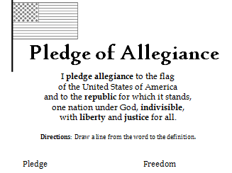
This printable handout includes the Pledge of Allegiance. Match each word with the definition: Pledge, Allegiance, Republic, Indivisible, Liberty, Justice.
Reading comprehension and vocabulary building.