Thank you for visiting! Here you will find a selection of printable, interactive worksheets for your classroom: Basic Geography worksheets with simple maps, ESL, Spanish, Bible, Reading Comprehension and more. I hope you find the resources useful! Reviews are welcome and very much appreciated. Thank you so much.
Thank you for visiting! Here you will find a selection of printable, interactive worksheets for your classroom: Basic Geography worksheets with simple maps, ESL, Spanish, Bible, Reading Comprehension and more. I hope you find the resources useful! Reviews are welcome and very much appreciated. Thank you so much.
Introduce your students to the island country of São Tomé and Príncipe in Africa with this printable handout of two worksheets (plus answer key). Your students will read a brief overview of São Tomé and Príncipe (location, capital, flag, language), write ‘São Tomé’ next to the star on the map to show the capital, trace the line of the equator, color the small map, and use the map and compass to answer 8 questions on page 2. Colored pencils and a pen or pencil are needed for this activity. No other prep needed. Basic Geography worksheet with a simple map to introduce São Tomé and Príncipe and practice cardinal and ordinal directions.
For use with Interactive Notebooks: After the handout is completed, students can cut out the map and flag and paste into the notebook under the topic of Africa/Sub-topic: São Tomé and Príncipe. Under the map and flag, your students can write a summary in their own words of what they now know about this country. Collect handouts for other countries of Africa to add to the notebook. Please browse this store for a selection of printable handouts for other countries of Africa (and beyond!).
Thank you so much for using my Geography worksheets in your classroom!
Rôlas, Caroço, Tinhosas, Portuguese
Introduce your students to the island country of MAURITIUS in Africa with two worksheets (plus answer key). Your students will read a brief introduction to Mauritius (location, capital, flag, language), write ‘Port Louis’ next to the star on the map to show the capital, color the small map, and use the map and compass to answer 8 questions on page 2. Colored pencils and a pen or pencil are needed for this activity. No other prep needed. Basic Geography worksheet with a simple map to introduce Mauritius and practice cardinal and ordinal directions.
For use with Interactive Notebooks: After the worksheets are completed, students can cut out the map and flag and paste into the notebook under the topic of Africa/Sub-topic: Mauritius. Under the map and flag, your students can write a summary in their own words of what they now know about this country. Collect worksheets for other countries of Africa to add to the notebook! Please browse this store for worksheets for other countries of Africa (and beyond!)
Thank you so much for using my Geography worksheets in your classroom! I hope you find them useful. Reviews are welcome and very much appreciated!
Mascarene Islands, Rodrigues, Réunion, Agaléga, Indian Ocean, Madagascar.
Introduce your students to the country of ESWATINI, formerly known as SWAZILAND in Africa with this printable handout of two worksheets (plus answer key). Your students will read a brief introduction to Eswatini (location, capital, flag, language), write ‘Mbabane and Lobamba’ next to the stars on the map to show the two capitals, color the small map, and use the map and compass to answer 7 questions on page 2. Colored pencils and a pen or pencil are needed for this activity. No other prep needed. Basic Geography worksheet with a simple map to introduce Eswatini/Swaziland and practice cardinal and ordinal directions.
For use with Interactive Notebooks: After the worksheets are completed, students can cut out the map and flag and paste into the notebook under the topic of Africa/Sub-topic: Eswatini. Under the map and flag, your students can write a summary in their own words of what they now know about this country. Collect worksheets for other countries of Africa to add to the notebook! Please browse this store for a selection of printable handouts for all other countries of Africa (and beyond!).
Thank you for using my Geography worksheets in your classroom! I hope you find them useful. Reviews are welcome and very much appreciated!
Introduce your students to the country of ZAMBIA in Africa with two worksheets (plus answer key). Your students will read a brief introducction to Zambia (location, capital, flag, language), write ‘Lusaka’ next to the star on the map to show the capital, trace the dotted line of Zambezi River and the lakes BLUE, color the small map, and use the map and compass to answer 9 questions on page 2. Colored pencils and a pen or pencil are needed for this activity. No other prep needed. Basic Geography worksheet with a simple map to introduce Zambia and practice cardinal and ordinal directions.
For use with Interactive Notebooks: After the worksheets are completed, students can cut out the map and flag and paste into the notebook under the topic of Africa/Sub-topic: Zambia. Under the map and flag, your students can write a summary in their own words of what they now know about this country. Collect worksheets for other countries of Africa to add to the notebook! Please browse this store for all other countries of Africa (and beyond!).
Thank you so much for using my Geography worksheets in your classroom! It is very much appreciated.
Included: Lake Tanganyika, Lake Mweru, Lake Kariba, Lake Bengweulu, Democratic Republic of the Congo, Tanzania, Malawi, Mozambique, Zimbabwe, Botswana, Namibia, Angola, Bemba, Nyanja, Tonga.
Introduce your students to Saudi Arabia with this printable handout of two worksheets (plus answer key). Your students will read a brief overview of Saudi Arabia (location, capital, language, flag), write ‘Riyadh’ next to the star on the map to show the capital, color the small map, and use the map and compass to answer 9 questions on page 2. Colored pencils and a pen or pencil are needed for this activity. No other prep needed. Basic Geography worksheet with a simple map to introduce Saudi Arabia and practice cardinal/ordinal directions.
For use with Interactive Notebooks: After your students complete the handout, they can cut out the map and paste into the notebook under the topic Asia or Middle East/Sub-topic: Saudi Arabia. Under the map, your students can write a summary in their own words of what they now know about this country. Collect handouts for other countries of Asia or the Middle East to add to the notebook! Please browse this store for a selection of printable handouts for other countries of the Middle East, Asia, and beyond!
Thank you so much for using my Geography worksheets in your classroom!
Inclued: Jordan, Iraq, Kuwait, Qatar, Bahrain, United Arab Emirates, Oman, Yemen, Israel, Egypt, Red Sea, Persian Gulf.
Introduce your students to the Maldives in South Asia with this printable handout of two worksheets (plus answer key). Your students will read a brief introduction to Maldives (location, capital, language, flag), write ‘Malé’ next to the star on the map to show the capital, trace the line of the equator, color the small map, and use the map and compass to answer 8 questions on page 2. Colored pencils and a pen or pencil are needed for this activity. No other prep needed. Basic Geography worksheet with a simple map to introduce the Maldives and practice cardinal/ordinal directions.
For use with Interactive Notebooks: After the worksheets are completed, students can cut out the map and flag and paste into the notebook under the topic of Asia/Sub-topic: Maldives. Under the map, your students can write a summary in their own words of what they now know about this country. Collect worksheets for other countries of Asia to add to the notebook! Please browse this store for a selection of printable handouts for other countries of Asia (and beyond!).
Thank you so much for using my Geography worksheets in your classroom! I hope you find them useful. Reviews are welcome and very much appreciated! Please browse this store for printable worksheets to introduce your students to the countries of the world!
Introduce your learners to the U.S. state of KANSAS with two worksheets (plus answer key). Your students will read a brief introduction to Kansas (location, capital, flag, state bird, state flower), write ‘Topeka’ next to the star on the map to show the location of the capital, trace the line of the Kansas River blue, color the small map of Kansas and surrounding states, color the state bird and state flower (Western Meadowlark and Sunflower) and use the map and compass to answer 9 questions on page 2. Colored pencils and a pen or pencil are needed for this activity. No other prep needed. Basic Geography worksheet with a simple map to introduce the state of Kansas and practice cardinal and ordinal directions.
For use with Interactive Notebooks: After the worksheets are completed, students can cut out the map, flag, state bird and state flower, and paste into the notebook under the topic of United States / Sub-Topic: Kansas. Under the map, students can write a summary in their own words of what they now know about this state. Collect worksheets for all U.S. states to add to notebook! Please browse this store for worksheets for other states of the USA (and beyond!).
Thank you so much for using my Geography worksheets in your classroom! I hope you find them useful. Reviews are welcome and very much appreciated.
Wichita, 34th state, Kansa Native Americans, Midwestern region, Nebraska, Missouri, Oklahoma, Colorado, Sunflower, Western Meadowlark
Introduce your students to the country of KUWAIT with this printable handout of two worksheets (plus answer key). Your students will read a brief introduction to Kuwait (location, capital, language, flag), write ‘Kuwait City’ next to the star on the map to show the location of the capital, color the small map, and use the map and compass to answer 8 questions on page 2. Colored pencils and a pen or pencil are needed for this activity. No other prep needed. Basic Geography worksheet with a simple map to introduce the country of Kuwait and practice cardinal/ordinal directions.
For use with Interactive Notebooks: After the worksheets are completed, students can cut out the map and flag and paste into the notebook under the topic of Asia (or Middle East) /Sub-topic: Kuwait. Under the map, your students can write a summary in their own words of what they now know about this country. Collect handouts for other countries of Asia or Middle East to add to the notebook! Please browse this store for a selection of Geography worksheets for other countries of Asia, the Middle East and beyond!
Thank you so much for using my Geography worksheets in your classroom! I hope you find them useful. Reviews are welcome and very much appreciated!
Introduce your learners to the country of Samoa in Oceania with two interactive worksheets (plus answer key). Your students will read a brief introduction to Samoa (location, capital, flag, language), locate and circle Samoa on the map of Oceania, write ‘Apia’ next to the star on the map of Samoa to show the location of the capital, color the small map, and use the map and compass to answer 7 multiple-choice questions on page 2. Colored pencils and a pen or pencil are needed for this activity. No other prep needed. Basic Geography worksheet with a simple map to introduce Samoa and practice cardinal and ordinal directions.
For use with Interactive Notebooks: After your students complete the worksheets, they can cut out the map and flag and paste into the notebook under the topic of (example) Oceania/Sub-Topic: Samoa. Under the map and flag, students can write a summary in their own words of what they now know about Samoa. Collect worksheets for other countries of Oceania to add to the notebook! Please browse this store for a selection of worksheets for other countries of Oceania (and beyond!).
Thank you so much for using my Geography worksheets in your classroom! I hope you find them useful and fun. Reviews are welcome and very much appreciated.
Introduce your learners to the U.S. state of HAWAII with this printable handout of two worksheets (plus answer key). Your students will read a brief introduction to Hawaii (location, capital, flag, language, main islands, state bird, state flower), write ‘Honolulu’ next to the star on the map on the island of Oahu to show the capital, color the small map, and answer 6 questions on page 2. Colored pencils and a pen or pencil are needed for this activity. No other prep needed. Basic Geography worksheet with a simple map to introduce the state of Hawaii.
For use with Interactive Notebooks: After the worksheets are completed, students can cut out the map, flag, state bird and flower of Hawaii and paste into the notebook under the topic of United States / Sub-Topic: Hawaii. Under the map, students can write a summary in their own words of what they now know about this state. Collect worksheets for all U.S. states to add to notebook! Please browse this store for a selection of worksheets for other states of the USA (and beyond!).
Thank you so much for using my Geography worksheets in your classroom! I hope you find them useful. Reviews are welcome and very much appreciated.
Islands included on map: Hawaii, Niihau, Kauai, Oahu, Molakai, Lanai, Kahoolawe, Maui. Pacific Ocean.
Introduce your learners to Afghanistan with two worksheets (plus answer key). Your students will read a brief introduction to Afghanistan (location, capital, language, flag), write ‘Kabul’ next to the star on the map to show the location of the capital, color the small map, and use the map and compass to answer questions on page 2. Colored pencils and a pen or pencil are needed for this activity. No other prep needed. Basic Geography worksheet with a simple map to introduce Afghanistan and practice cardinal/ordinal directions.
For use with Interactive Notebooks: After completing the worksheet, students can cut out the map and paste into the notebook under the topic Asia/Sub-topic: Afghanistan. Under the map, students can write a summary in their own words of what they now know about this country. Collect worksheets for other countries of Asia to add to the notebook! Please browse this store for a selection of printable worksheets for other countries of Asia (and beyond!)
Thank you so much for using my Geography worksheets. I hope you find them useful! Reviews are welcome and very much appreciated.
Introduce your learners to the country of Oman with this printable handout of two worksheets (plus answer key). Your students will read a brief introduction to Oman (location, capital, language, flag), write ‘Muscat’ next to the star on the map to show the capital, color the small map, and use the map and compass to answer 6 questions on page 2. Colored pencils and a pen or pencil are needed for this activity. No other prep needed. Basic Geography worksheet with a simple map to introduce Oman and practice cardinal/ordinal directions.
For use with Interactive Notebooks: After your students complete the worksheets, they can cut out the map and flag and paste into the notebook under the topic of Asia or Middle East/Sub-topic: Oman. Under the map, students can write a summary in their own words of what they now know about this country. Collect handouts for other countries of Asia or Middle East to add to the notebook! Please browse this store for a selection of printable Geography worksheets for countries of the Middle East, Asia (and beyond!).
Thank you so much for using my Geography worksheets in your classroom! I hope you find them useful. Reviews are welcome and very much appreciated! Please browse this store for worksheets to introduce your learners to the countries of the world!
Introduce your learners to QATAR with this printable handout of two worksheets (plus answer key). Your students will read a brief introduction to Qatar (location, capital, language, flag), write ‘Doha’ next to the star on the map to show the capital, color the small map, and use the map and compass to answer 8 questions on page 2. Colored pencils and a pen or pencil are needed for this activity. No other prep needed. Basic Geography worksheet with a simple map to introduce Qatar and practice cardinal/ordinal directions.
For use with Interactive Notebooks: After the worksheets are completed, students can cut out the map and flag and paste into the notebook under the topic of Asia or Middle East / Sub-topic: Qatar. Under the map, students can write a summary in their own words of what they now know about this country. Collect handouts for other countries of Asia or Middle East to add to the notebook! Please browse this store for a selection of printable Geography worksheets for other countries of the Middle East, Asia (and beyond!).
Thank you so much for using my Geography worksheets in your classroom! I hope you find them useful. Reviews are welcome and very much appreciated! Please browse this store for a selection of worksheets to introduce your students to the countries of the world!
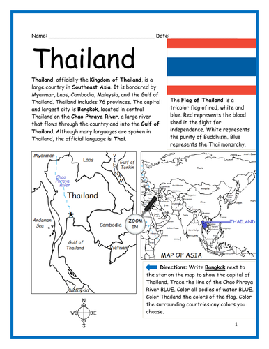
Introduce your learners to THAILAND in Southeast Asia with this printable handout of two worksheets (plus answer key). Your students will read a brief introduction to Thailand (location, capital, language, flag), write ‘Bangkok’ next to the star on the map to show the capital, trace the line of the Chao Phraya River, color the small map, and use the map and compass to answer 9 questions on page 2. Colored pencils and a pen or pencil are needed for this activity. No other prep needed. Basic Geography worksheet with a simple map to introduce Thailand and practice cardinal and ordinal directions.
For use with Interactive Notebooks: After the worksheets are completed, students can cut out the map and flag paste into the notebook under the topic of Asia/Sub-topic: Thailand. Under the map, your students can write a summary in their own words of what they now know about this country. Collect worksheets for other countries of Asia to add to the notebook! All available in this store! Please browse this store for a selection of printable worksheets for other countries of Asia (and beyond!).
Thank you so much for using my Geography worksheets in your classroom! I hope you find them useful. Reviews are welcome and very much appreciated!
Included: Myanmar, Laos, Cambodia, Malaysia, Gulf of Thailand, Vietnam, Gulf of Andaman.
Introduce your learners to the Philippines in Southeast Asia with this printable handout of two worksheets (plus answer key). Your students will read a brief introducction to the Philippines (location, capital, language, flag), write ‘Manila’ next to the star on the map to show the capital, trace the lines to separate the islands into three regions: Luzon, Visayas and Mindanao, color the small map, and use the map and compass to answer 9 questions on page 2. Colored pencils and a pen or pencil are needed for this activity. No other prep needed. Basic Geography worksheet with a simple map of Philippines and Southeast Asia to introduce the Philippines and practice cardinal and ordinal directions.
For use with Interactive Notebooks: After the worksheets are completed, students can cut out the map and flag paste into the notebook under the topic Asia/Sub-topic: Philippines. Under the map, your students can write a summary in their own words of what they now know about this country. Collect worksheets for other countries of Asia to add to the notebook! Please browse this store for a selection of printable worksheets for other countries of Asia (and beyond!).
Thank you so much for using my Geography worksheets in your classroom! I hope you find them useful… Reviews are welcome and very much appreciated! Please browse this store for worksheets to introduce your students to the countries of the world.
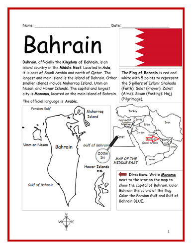
Introduce your learners to the country of Bahrain with this printable handout of two worksheets (plus answer key). Your students will read a brief introduction to Bahrain (location, capital, language, flag), write ‘Manama’ next to the star on the map to show the capital, color the small map, and use the map and compass to answer 8 questions on page 2. Colored pencils and a pen or pencil are needed for this activity. No other prep needed. Basic Geography worksheet with a simple map to introduce Bahrain and practice cardinal/ordinal directions.
For use with Interactive Notebooks: After your students complete the worksheets, they can cut out the map and flag and paste into the notebook under the topic of Asia or Middle East / Sub-topic: Bahrain. Under the map, students can write a summary in their own words of what they now know about this country. Collect handouts for other countries of Asia or Middle East to add to the notebook! Please browse this store for a selection of worksheets for other countries of the Middle East, Asia, and beyond!
Thank you for using my worksheets in your classroom! I hope you find them useful. Reviews are welcome and very much appreciated!
Introduce your learners to the state of West Virginia in the USA with two worksheets (plus answer key). Your students will read a brief introduction to West Virginia (location, capital, flag, state bird, state flower), write ‘Charleston’ next to the star on the map to show the location of the capital, color the small map, and use the map and compass to answer 8 questions on page 2. Colored pencils and a pen or pencil are needed for this activity. No other prep needed. Basic Geography worksheet with a simple map to introduce the state of West Virginia and practice cardinal and ordinal directions.
For use with Interactive Notebooks: After the worksheets are completed, students can cut out the map, flag, state bird (Northern Cardinal) and state flower (Rhododendron), and paste into the notebook under the topic of United States / Sub-Topic: West Virginia. Under the map, students can write a summary in their own words of what they now know about this state. Collect worksheets for other states of the US to add to the notebook! Please browse this store for a worksheets for all 50 states of the USA (and beyond!)
Thank you so much for using my worksheets in your classroom! I hope you find them useful. Reviews are welcome and very much appreciated!
Included: Pennsylvania, Maryland, Virginia, Kentucky, Ohio, Appalachian mountains, motto Montani Semper Liberi (mountaineers are always free).
Introduce your learners to the country of Kyrgyzstan in Central Asia with this printable handout of two worksheets (plus answer key). Printable or digital. Your students will read a brief overview of Kyrgyzstan (location, capital, language, flag), write ‘Bishkek’ next to the star on the map to show the capital, color the small map, and use the map and compass to answer 8 true/false questions on page 2. Colored pencils and a pen or pencil are needed for this activity. No other prep needed. Basic Geography worksheet with a simple map to introduce the country of Kyrgyzstan and practice cardinal and ordinal directions.
For use with Interactive Notebooks: After your students complete the worksheets, they can cut out the map and flag of Kyrgyzstan and paste into the notebook under the topic of Asia / Sub-topic: Kyrgyzstan. Under the map, students can write a summary in their own words of what they now know about this country. Collect worksheets for other countries of Asia to add to the notebook! Please browse this store for a selection of worksheets for other countries of Asia (and beyond!).
Thank you so much for using my Geography worksheets in your classroom! Reviews are welcome and very much appreciated.
Included: Kazakhstan, Uzbekistan, Tajikistan, China, Yurt, Manas, Kyrgyz and Russian.
Introduce your learners to the country of LAOS in Asia with this printable handout of two worksheets (plus answer key). Your students will read a brief overview of Laos (location, capital, language, flag), write ‘Vientiane’ next to the star on the map to show the capital, color the small map, and use the map and compass to answer 8 true/false questions on page 2. Colored pencils and a pen or pencil are needed for this activity. No other prep needed. Basic Geography worksheet with a simple map to introduce the country of Laos and practice cardinal and ordinal directions.
For use with Interactive Notebooks: After your students complete the worksheets, they can cut out the map and flag of Laos and paste into the notebook under the topic of Asia / Sub-topic: Laos. Under the map, students can write a summary in their own words of what they now know about this country. Collect worksheets for other countries of Asia to add to the notebook! Please browse this store for a selection of printable worksheets for other countries of Asia (and beyond!).
Thank you so much for using my Geography worksheets in your classroom! I hope you find them useful and fun. Reviews are welcome and very much appreciated!
Introduce your learners to the state of NEW MEXICO in the USA with this printable handout of two worksheets (plus answer key). Your students will read a brief overview of New Mexico (location, capital, flag, state bird, state flower), write ‘Santa Fe’ next to the star on the map to show the location of the capital, color the small map, and use the map and compass to answer 10 true/false questions on page 2. Colored pencils and a pen or pencil are needed for this activity. No other prep needed. Basic Geography worksheet with a simple map to introduce New Mexico and practice cardinal and ordinal directions.
For use with Interactive Notebooks: After the worksheets are completed, students can cut out the map and flag of New Mexico and paste into the notebook under the topic of United States/Sub-Topic: New Mexico. Under the map, students can write a summary in their own words of what they now know about this state. Collect worksheets for other states of the US to add to the notebook! Please browse this store for a selection of worksheets for other states of the USA (and beyond!).
Thank you so much for using my worksheets in your classroom! Reviews are welcome and very much appreciated.
Included: Colorado, Oklahoma, Texas, Arizona, Mexico, Albuquerque, Greater Roadrunner, Yucca Flower, Zia sun symbol, Land of Enchantment, southwestern region.