Thank you for visiting! Here you will find a selection of printable, interactive worksheets for your classroom: Basic Geography worksheets with simple maps, ESL, Spanish, Bible, Reading Comprehension and more. I hope you find the resources useful! Reviews are welcome and very much appreciated. Thank you so much.
Thank you for visiting! Here you will find a selection of printable, interactive worksheets for your classroom: Basic Geography worksheets with simple maps, ESL, Spanish, Bible, Reading Comprehension and more. I hope you find the resources useful! Reviews are welcome and very much appreciated. Thank you so much.
Introduce your learners to Albania in Europe with this printable handout of two worksheets (plus answer key). Your students will read a brief introduction to Albania (location, capital, flag, language), write ‘Tirana’ next to the star on the map to show the location of the capital, color the small map, and use the map and compass to answer 7 questions on page 2. Colored pencils and a pen or pencil are needed for this activity. No other prep needed. Basic Geography worksheet with a simple map to introduce Albania and practice cardinal and ordinal directions.
For use with Interactive Notebooks: After completing the worksheets for Albania, students can cut out the map and flag and paste into the notebook under the topic of Europe / Sub-Topic: Albania. Under the map and flag, students can write a summary in their own words of what they now know about this country. Collect worksheets for other countries of Europe to add to the notebook! Please browse this store for a selection of worksheets for other countries of Europe (and beyond!).
Thank you so much for using my Geography worksheets in your classroom! I hope you find them useful and fun. Reviews are welcome and very much appreciated. :)
Introduce your learners to AUSTRIA with two worksheets (plus answer key). Your students will read a brief introduction to Austria (location, capital, flag, language), write ‘Vienna’ next to the star on the map to show the location of the capital, color the small map and flag, and use the map and compass to answer 7 questions on page 2. Colored pencils and a pen or pencil are needed for this activity. No other prep needed. Basic Geography worksheet with a simple map to introduce Austria and practice cardinal and ordinal directions.
For use with Interactive Notebooks: After the worksheets are completed, students can cut out the map and flag and paste into the notebook under the topic of Europe / Sub-topic: Austria. Under the map, students can write a summary in their own words of what they now know about Austria. Collect worksheets for other countries of Europe to add to the notebook! All available in this store! Please browse this store for a selection of printable Geography worksheets for other countries of Europe (and beyond!).
Thank you for using my Geography worksheets in your classroom! I hope you find them useful. Reviews are welcome and very much appreciated!
German
Introduce your learners to Finland with two worksheets (plus answer key). Your students will read a brief introduction to Finland (location, capital, flag, language), write 'Helsinki' next to the star on the map to show the location of the capital, color the map, and use the map and compass to answer 6 questions on page 2. Colored pencils and a pen or pencil are needed for this activity. No other prep needed. Basic Geography worksheet with a simple map to introduce Finland and practice cardinal and ordinal directions.
For use with Interactive Notebooks: After completing the worksheets, students can cut out the map and flag and paste it into the notebook under the topic of Europe / Sub-Topic: Finland. Under the map and flag, students can write a summary in their own words of what they now know about Finland. Collect worksheets for other countries of Europe to add to the notebook! Please browse this store for worksheets for other countries of Europe (and beyond!)
Thank you so much for using my worksheets in your classroom!
Introduce your students to Argentina with this printable handout of two worksheets (plus answer key). Your students will read a brief overview of Argentina (location, capital, flag, language), write 'Buenos Aires' next to the star on the map to show the capital, color the small map and flag, and use the map and compass to answer 7 questions. Colored pencils and a pen or pencil are needed for this activity. No other prep needed. Basic Geography worksheet with a simple map to introduce Argentina and practice cardinal and ordinal directions.
For use with Interactive Notebooks: After the worksheets are completed, students can cut out the map and paste into the notebook under the topic of South America/Sub-topic: Argentina. Under the map, students can write a summary in their own words of what they now know about this country. Collect worksheets for other countries of South America to add to the notebook! Please browse this store for a selection of printable worksheets for other countries of South America (and beyond)!
Thank you so much for using my Geography worksheets in your classroom!
Teach your students about Africa with this packet of 7 printable worksheets.
Page 1 is a list of the 54 countries of Africa in alphabetical order.
Page 2 is a map of Africa. Your students will write the name of each country on the map.
Page 3: Word Search: Find African countries A-L.
Page 4: Word Search: Find African countries M-Z.
Pages 5-6: List the 54 countries of Africa A-Z (your students will see how many they can remember on their own before referring to the list and map).
Page 7: Languages of Africa. Fill in the blank.
Thank you for using my Geography worksheets in your classroom!
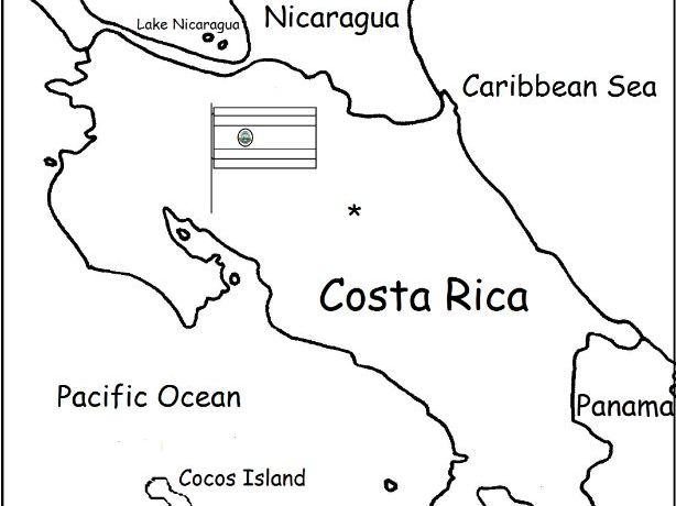
Introduce your students to Costa Rica with two worksheets (plus answer key). Your students will read a brief introduction to Costa Rica (location, capital, language, flag), write 'San José' next to the star on the map to show the location of the capital, color the small flag and map, and use the map and compass to answer 6 questions on page 2. Colored pencils and a pen or pencil are needed for this activity. No other prep needed. Basic Geography worksheet with a simple map to introduce Costa Rica and practice cardinal and ordinal directions.
For use with Interactive Notebooks: After the worksheets are completed, students can cut out the map and flag and paste into the notebook under the topic of Central America (or Spanish-Speaking Countries) /Sub-Topic: Costa Rica. Under the map and flag, students can write a summary in their own words of what they now know about this country. Collect worksheets for other countries of Central America (or Spanish-Speaking Countries) to add to the notebook! Worksheets for all countries available in this store! Please browse this store for a selection of printable Geography worksheets for other countries of Central America and beyond!
Thank you so much for using my Geography worksheets in your classroom! I hope you find them useful. Reviews are welcome and very much appreciated! Please browse this store for a selection of worksheets to introduce your learners to the countries of the world!
Introduce your learners to Panama with two printable worksheets (plus answer key). Your students will read a brief introduction to Panama (location, capital, flag, language), write ‘Panama City’ next to the star on the map to show the location of the capital, color the small flag and map, and use the map and compass to answer 10 questions on page 2. Colored pencils and a pen or pencil are needed for this activity. No other prep needed. Basic Geography worksheet with a simple map to introduce Panama and practice cardinal and ordinal directions.
For use with Interactive Notebooks: After the worksheets are completed, students can cut out the map and flag and paste into the notebook under the topic of (example): Central America or Spanish-Speaking Countries / Sub-Topic: Panama. Under the map and flag, students can write a summary in their own words about what they now know about this country. Collect worksheets for other countries of Central America (or Spanish-Speaking Countries) to add to the notebook! All available in this store! Please browse this store for worksheets for countries of Central America and beyond!
Thank you so much for using my Geography worksheets in your classroom! I hope you find them useful. Reviews are welcome and very much appreciated! Please browse this store for worksheets to introduce your learners to the countries of the world!
Key words: Panama canal, Spanish, cardinal, ordinal directions.
This printable handout of one page includes a map of South America. Your students will write each country of South America on the map, using the list of countries to fill in the blanks: Argentina, Bolivia, Brazil, Chile, Colombia, Ecuador, French Guiana, Guyana, Paraguay, Peru, Suriname, Uruguay, and Venezuela, as well as the Pacific Ocean and Atlantic Ocean. Then your students can color the map. Colored pencils or crayons and a pen or pencil are needed for this activity. No other prep needed.
Find each country of South America (and two dependent territories) in the Word Search Puzzle. They can be found forward or backward. Then write the remaining letters on the lines below for two facts about South America.
Argentina, Bolivia, Brazil, Chile, Colombia, Ecuador, Guyana, Paraguay, Peru, Suriname, Uruguay, Venezuela, and dependent territories French Guiana and Falkland Islands.
Remaining letters will spell out: The largest country in South America is Brazil. The smallest country in South America is Suriname.
1 printable handout plus answer key.
Thank you!!
This printable handout of 2 pages (plus answer key) includes a map and flag of Colombia. Your students will fill in the blanks for each Colombia and surrounding countries (Venezuela, Brazil, Peru, Ecuador, and Panama) and the Atlantic and Pacific Ocean, write Bogotá next to the star on the map to show the capital of Colombia, color the flag and map, and then use the map and compass to answer 7 questions.
Introduce your students to the country of SENEGAL in West Africa with this printable handout of two worksheets (plus answer key). Your students will read a brief overview of Senegal (location, capital, flag, language), write ‘Dakar’ next to the star on the map to show the capital, write ‘Casamance’ in the area of Senegal south of The Gambia, color the small map, and use the map and compass to answer 10 questions on page 2. Colored pencils and a pen or pencil are needed for this activity. No other prep needed. Basic Geography worksheet with a simple map to introduce the country of Senegal and practice cardinal/ordinal directions.
For use with Interactive Notebooks: After the handout is completed, students can cut out the map and flag and paste into the notebook under the topic of Africa/Sub-topic: Senegal. Under the map and flag, your students can write a summary in their own words of what they now know about this country. Collect handouts for other countries of Africa to add to the notebook! Please browse this store for a selection of printable handouts for other countries of Africa (and beyond!).
Thank you so much for using my Geography worksheets in your classroom!
Introduce your students to the country of LESOTHO in Africa with two worksheets (plus answer key). Your students will read a brief introduction to Lesotho (location, capital, flag, language), write ‘Maseru’ next to the star on the map to show the location of the capital, trace the line of the Caledon River, color the small map, and use the map and compass to answer 6 multiple-choice questions on page 2. Colored pencils and a pen or pencil are needed for this activity. No other prep needed. Basic Geography worksheet with a simple map to introduce the country of Lesotho.
For use with Interactive Notebooks: After the worksheets are completed, students can cut out the map and flag and paste into the notebook under the topic of Africa/Sub-topic: Lesotho. Under the map and flag, your students can write a summary in their own words of what they now know about this country. Collect worksheets for other countries of Africa to add to the notebook! Please browse this store for a selection of printable handouts for all other countries of Africa (and beyond!)
Thank you so much for using my Geography worksheets in your classroom! I hope you find them useful. Reviews are welcome and very much appreciated!
Introduce your students to the country of Australia with this printable handout of two worksheets (plus answer key). Your students will read a brief overview of Australia (location, capital, flag), write ‘Canberra’ next to the star on the map to show the capital, color the small map, and use the map and compass to answer 6 questions on page 2. Colored pencils and a pen or pencil are needed for this activity. Basic Geography worksheet with a simple map to introduce the country of Australia and practice cardinal and ordinal directions.
For use with Interactive Notebooks: After the handout is completed, students can cut out the map and flag of Australia and paste into the notebook. Under the map and flag, students can write a summary in their own words of what they now know about this country. Collect handouts for other countries to add to the notebook. Please browse this store for a selection of printable Geography worksheets!
Thank you so much for using my Geography worksheets in your classroom!
Included: Indian Ocean, Pacific Ocean, Sydney, Melbourne, Brisbane, Perth, Adelaide.
Introduce your students to the country of LEBANON with this printable handout of two worksheets (plus answer key). Your students will read a brief introduction to Lebanon (location, capital, language, flag), write ‘Beirut’ next to the star on the map to show the capital, color the small map, and use the map and compass to answer 7 questions on page 2. Colored pencils and a pen or pencil are needed for this activity. No other prep needed. Basic Geography worksheet with a simple map to introduce Lebanon and practice cardinal/ordinal directions.
For use with Interactive Notebooks: After your students complete the handout, they can cut out the map and and flag and paste into the notebook under the topic of Asia (or Middle East) /Sub-topic: Lebanon. Under the map, your students can write a summary in their own words of what they now know about this country. Collect handouts for other countries of Asia or Middle East to add to the notebook! Please browse this store for a selection of printable handouts for other countries of Asia, the Middle East, and beyond!
Thank you so much for using my Geography worksheets in your classroom! I hope you find them useful. Reviews are welcome and very much appreciated! Please browse this store for more worksheets to use in your classroom!
Mediterranean Sea
Resource Room
Introduce your learners to the GREAT LAKES of North America with this printable handout of two worksheets (plus answer key). Your students will write the names of the 5 Great Lakes on the map, color the map (Great Lakes, Canada, United States) and use the map to answer 9 questions on page 2.
Included on this map: Lake Superior; Lake Michigan; Lake Huron; Lake Erie; Lake Ontario; Canada Provinces Ontario and Quebec; US States: Minnesota; Wisconsin; Iowa; Illinois; Indiana; Michigan; Ohio; Pennsylvania; New York.
Thank you for using my Geography worksheets! Please browse this store for a selection of printable Geography worksheets for North America and beyond.
Introduce your learners to the African Great Lakes with two printable worksheets (plus answer key). Simple map activity and reading comprehension questions. Your students will read a short passage about the African Great Lakes, trace the lines of each of the 9 Great Lakes on map 1 and color the lakes and surrounding countries. The African Great Lakes include: Lake Victoria, Lake Tanganyika, Lake Malawi, Lake Turkana, Lake Albert, Lake Edward, Lake Kivu, Lake Rukwa, and Lake Mweru. On map 2, a small map of Africa, place a blue dot to show the location of each of the 9 Great Lakes, then using the maps, answer 5 multiple choice questions on page 2.
Countries of the African Great Lakes Region included on this map: Uganda, Kenya, Tanzania, Malawi, the Democratic Republic of the Congo (DR Congo), Burundi and Rwanda. Also included on map: Mozambique, Zambia, Ethiopia and South Sudan.
If you’d like to introduce your learners to the 10 COUNTRIES of the African Great Lakes region, do so one country at a time with a printable worksheet for each country! Available individually or as a discounted bundle! Please click on this link for more info: https://www.tes.com/teaching-resource/african-great-lakes-region-countries-introductory-worksheets-bundle-12777435
Thank you so much for using my Geography worksheets in your classroom! I hope you find them useful. Reviews are welcome and very much appreciated. Please browse this store for a selection of printable Geography worksheets to introduce your students to the countries of the world!
Introduce your learners to the U.S. state of WASHINGTON with two worksheets (plus answer key). Your students will read a brief introduction to Washington (location, capital, flag, state bird, state flower), write ‘Olympia’ next to the star on the map to show the capital, color the small map, state bird (American Goldfinch) and state bird (Rhododendron), and use the map and compass to answer 9 questions on page 2. Colored pencils and a pen or pencil are needed for this activity. No other prep needed. Basic Geography worksheet with a simple map to introduce the state of Washington and practice cardinal and ordinal directions.
For use with Interactive Notebooks: After the worksheets are completed, students can cut out the map, flag, state bird and state flower, and paste into the notebook under the topic of United States/Sub-Topic: Washington. Under the map, students can write a summary in their own words of what they now know about this state. Collect worksheets for all U.S. states to add to notebook! Please browse this store for a selection of printable Geography worksheets for all 50 states of the USA!
Thank you so much for using my Geography worksheets in your classroom. I hope you find them useful. Reviews are welcome and very much appreciated.
Included on map: Oregon, Idaho, Canada, Pacific Ocean, Seattle, State Seal.
Introduce your learners to Washington D.C. - the capital of the United States of America, with this printable handout of two worksheets (plus answer key). Your students will read a brief overview of Washington D.C., write ‘White House’ next to the star on the map to show the location of the White House, color the small map, and answer 8 True/False questions on page 2. Colored pencils and a pen or pencil are needed for this activity. No other prep needed. Basic Geography worksheet with a simple map to introduce Washington D.C.
For use with Interactive Notebooks: After the worksheets are completed, students can cut out the map and flag of Washington D.C. and paste into the notebook under the topic of United States / Sub-Topic: Washington D.C… Under the map, students can write a summary in their own words of what they now know about Washington D.C. Collect worksheets for all U.S. states to add to notebook! Please browse this store for a selection of printable Geography worksheets for all states of the USA (and beyond!).
Thank you so much for using my Geography worksheets in your classroom! I hope you find them useful. Reviews are welcome and very much appreciated.
District of Colombia, Potomac River, Virginia, Maryland. State Bird and State Flower. Wood Thrush. American Beauty Rose
Introduce your learners to the country of Yemen with this printable handout of two worksheets (plus answer key). Your students will read a brief introduction to Yemen (location, capital, language, flag), write ‘Sana’a’ next to the star on the map to show the capital (Aden declared as the temporary capital in 2015), color the small map, and use the map and compass to answer 6 multiple-choice questions on page 2. Colored pencils and a pen or pencil are needed for this activity. No other prep needed. Basic Geography worksheet with a simple map to introduce Yemen and practice cardinal/ordinal directions.
For use with Interactive Notebooks: After your students complete the worksheets, they can cut out the map and flag and paste into the notebook under the topic of Asia or Middle East / Sub-topic: Yemen. Under the map, students can write a summary in their own words of what they now know about this country. Collect worksheets for other countries of Asia or Middle East to add to the notebook! All available in this store! Please browse this store for a selection of printable worksheets for other countries of the Middle East and Asia (and beyond!)
Thank you so much for using my Geography worksheets in your classroom! I hope you find them useful. Reviews are welcome and very much appreciated!
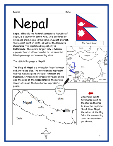
Introduce your learners to the country of Nepal in Asia with this printable handout of two worksheets (plus answer key). Your students will read a brief introduction to Nepal (location, capital, language, flag), write ‘Kathmandu’ next to the star on the map to show the location of the capital, color the small map, and use the map and compass to answer 8 multiple-choice questions on page 2. Colored pencils and a pen or pencil are needed for this activity. No other prep needed. Basic Geography worksheet with a simple map to introduce Nepal and practice cardinal/ordinal directions.
For use with Interactive Notebooks: After your students complete the worksheets, they can cut out the map and flag and paste into the notebook under the topic of Asia / Sub-topic: Nepal. Under the map, students can write a summary in their own words of what they now know about this country. Collect worksheets for other countries of Asia to add to the notebook! Please browse this store for a selection of printable worksheets for other countries of Asia (and beyond!).
Thank you for using my Geography worksheets in your classroom! I hope you find them useful. Reviews are welcome and very much appreciated!
Included: China, India, Mount Everest, Himalayas, Pokhara, Rhododendron