Thank you for visiting! Here you will find a selection of printable, interactive worksheets for your classroom: Basic Geography worksheets with simple maps, ESL, Spanish, Bible, Reading Comprehension and more. I hope you find the resources useful! Reviews are welcome and very much appreciated. Thank you so much.
Thank you for visiting! Here you will find a selection of printable, interactive worksheets for your classroom: Basic Geography worksheets with simple maps, ESL, Spanish, Bible, Reading Comprehension and more. I hope you find the resources useful! Reviews are welcome and very much appreciated. Thank you so much.
Introduce your learners to Cuba with this printable handout of 2 worksheets (plus answer key). Your students will read a brief introduction to Cuba (location, capital, flag), write ‘Havana’ next to the star on the map to show the location of the capital, color color the flag and map of Cuba, then use the map and compass to answer 5 multiple-choice questions on page 2. Colored pencils and a pen or pencil are needed for this activity. No other prep needed. Basic Geography worksheet with a simple map to introduce Cuba and practice cardinal and ordinal directions.
For use with Interactive Notebooks: After the worksheets are completed, students can cut out the map and flag and paste into the notebook under the topic of Caribbean / Sub-topic: CUBA. Under the map, your students can write a summary in their own words of what they now know about Cuba. Collect worksheets for other countries to add to the notebook! Please browse this store for a selection of worksheets for other countries of the Caribbean (and beyond!).
Thank you so much for using my Geography worksheets in your classroom! I hope you find them useful. Reviews are welcome and very much appreciated!
Cuba and surrounding: Jamaica, Haiti, Dominican Republic, Mexico, Belize, Guatemala, Honduras, United States, Florida, the Bahamas, Caribbean Sea, Atlantic Ocean, Gulf of Mexico. North America, Central America. Cardinal, ordinal directions. Isla de la Juventud.
Note: This handout is in American English. For British English, please visit this link: https://www.tes.com/teaching-resource/cuba-printable-handout-british-english-11997673
Can your students name all 50 states of the United States of America? This bundle includes a printable map of the United States to color and learn; a printable map where your students will write the name of each state on the map, a printable worksheet where your students will fill in the blank letters for each US State, and a Word Search Puzzle where your students will find all 50 states in the puzzle and then write the leftover letters to spell out a fun-fact about the United States. (The ‘fun fact’ from the leftover letters will read: The longest boardwalk in the world is located in the United States in New Jersey in Atlantic City.) Also included is a blank State Fact Sheet that your students can use to research a specific state. The Pledge of Allegiance worksheet to match the word to the definition (pledge, allegiance, republic, indivisible, liberty, justice).
Thank you so much for using my printable worksheets in your classroom!
Introduce your students to the United States of America with two worksheets (plus answer key). Your students will read a brief introduction to the United States (location, capital, flag, language, 13 original colonies), write ‘Washington D.C.’ next to the star on the map to show the location of the capital, color the small map, and use the map and compass to answer 10 questions on page 2.
Please note: This map includes the United States and surrounding, including Canada, Mexico, Atlantic Ocean, Pacific Ocean, Arctic Ocean, Gulf of Mexico, Cuba, Haiti, Dominican Republic, Puerto Rico. Individual states of America are not included on this map (except for Alaska, Hawaii and 13 original colonies). For worksheets to introduce your learners to each of the 50 states of the USA, please browse this store!
For use with Interactive Notebooks: After the worksheet is completed, students can cut out the map and flag and paste into the notebook under the topic of North America/Sub-Topic: United States. Under the map and flag, students can write a summary in their own words of what they now know about the United States of America! Collect worksheets for other countries of North America to add to the notebook! Please browse this store for worksheets to introduce your learners to countries of North America, such as Canada, Mexico, Cuba, Dominican Republic, Haiti, Puerto Rico, and countries of Central America!
Thank you so much for using my Geography worksheets in your classroom! I hope you find them useful. Reviews are welcome and very much appreciated.
Included: Washington D.C. formerly District of Columbia, named after first president and Founding Father George Washington.
Introduce your students to Japan with this printable handout of two worksheets (plus answer key). Your students will read a brief introductin to Japan (location, capital, flag, language), write ‘Tokyo’ next to the star on the map to show the location of the capital, color the small map and flag, and use the map and compass to answer 7 questions on page 2. Colored pencils and a pen or pencil are needed for this activity. No other prep needed. Basic Geography worksheet with a simple map to introduce Japan and practice cardinal and ordinal directions.
For use with Interactive Notebooks: After the worksheets are completed, students can cut out the map and flag and paste into the notebook under the topic of Asia / Sub-Topic: Japan. Under the map and flag, your students can write a summary in their own words of what they now know about this country. Collect handouts for other countries of Asia to add to the notebook! Please browse this store for a selection of worksheets for all other countries of Asia (and beyond!)
Thank you so much for using my Geography worksheets in your classroom! I hope you find them useful. Reviews are welcome and very much appreciated!
Japanese Archipelago, Islands of Honshu, Hokkaido, Kyushu, Shikoku.
Nisshōki, Hinomaru, Maritime borders. Dialect. Okinawa, Ryukyu Islands.
This dual-language vocabulary packet includes 6 printable worksheets for teaching NUMBERS 1-10 in Spanish and English (plus answer key for quiz). Use this packet as a supplement to the Printable Bilingual Picture Dictionary, or on its own.
Los números en Español e Ingles
Page 1: Read and write numbers 1-5 in Spanish and English.
Page 2: Read and write numbers 6-10 in Spanish and English
Page 3: Draw a line from each word in Spanish and English to the correct number.
Page 4: Word Search - Search for numbers 1-10 in Spanish and English.
Page 5: Fill in the blank for each number in Spanish and English.
Page 6: Quiz: Write the word in Spanish and English next to the number.
Page 7: Answer Key.
Thank you for using my printable handouts in your classroom! Reviews are welcome and very much appreciated.
Illustrations are used with permission from Pro Lingua Associates, publisher of Coloring in English - A Vocabulary Builder for Beginners. Coloring in English includes 400 everyday, basic vocabulary words in English with pictures to color and learn.
Introduce your students to Bangladesh with this printable handout of two worksheets (plus answer key). Your students will read a brief introduction to Bangladesh (location, capital, flag, language), write ‘Dhaka’ next to the star on the map to show the location of the capital, color the small map and flag, and use the map and compass to answer 6 questions on page 2. Colored pencils and a pen or pencil are needed for this activity. No other prep needed. Basic Geography worksheet with a simple map to introduce Bangladesh and practice cardinal and ordinal directions.
For use with Interactive Notebooks: After the worksheets are completed, students can cut out the map and flag and paste into the notebook under the topic of Asia / Sub-topic: Bangladesh. Under the map and flag, students can write a summary in their own words of what they now know about this country. Collect worksheets for other countries of Asia to add to the notebook! Please browse this store for a selection of worksheets for countries of Asia (and beyond!)
Thank you for using my Geography worksheets in your classroom! I hope you find them useful. Reviews are welcome and very much appreciated!
Introduce your learners to Kenya with two worksheets (plus answer key). Your students will read a brief introduction to Kenya (location, capital, flag, language), write ‘Nairobi’ next to the star on the map to show the location of the capital, trace the line of the equator across Kenya, color the small map and flag, and use the map and compass to answer 9 questions on page 2. Colored pencils and a pen or pencil are needed for this activity. No other prep needed. Basic Geography worksheet with a simple map to introduce Kenya and practice cardinal and ordinal directions.
For use with Interactive Notebooks: After the worksheets are completed, students can cut out the map and flag and paste into the notebook under the topic of Africa / Sub-Topic: Kenya. Under the map and flag, students can write a summary in their own words of what they now know about this country. Collect worksheets for other countries of Africa to add to the notebook! Please browse this store for a selection of worksheets for other countries of Africa (and beyond!).
Thank you so much for using my Geography worksheets in your classroom! Reviews are welcome and very much appreciated.
Introduce your students to the country of GEORGIA with this printable handout of two worksheets (plus answer key). Your students will read a short introductory passage about Georgia (location, capital, flag, language), write ‘Tbilisi’ next to the star on the map to show the location of the capital, color the small map and flag, and use the map and compass to answer 7 questions on page 2. Colored pencils and a pen or pencil are needed for this activity. No other prep needed. Basic Geography worksheet with a simple map to introduce the country of Georgia and practice cardinal and ordinal directions.
For use with Interactive Notebooks: After completing the worksheets, students can cut out the map and flag and paste it into the notebook under the topic of Europe (or Asia or Eurasia) / Sub-Topic: Georgia. Under the map and flag, students can write a summary in their own words of what they now know about the country of Georgia. Collect worksheets for other countries to add to the notebook! Please browse this store for a selection of worksheets for other countries of Europe, Asia, and beyond!
Thank you so much for using my Geography worksheets in your classroom! Reviews are welcome and very much appreciated.
Caucasus region, Black Sea, Caspian Sea, cardinal and ordinal directions.
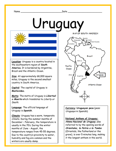
This printable handout includes a fact sheet about Uruguay (info such as location, climate, language, currency, national motto), followed by a cloze activity/fill-in-the-blank page.
Thank you for using my Geography worksheets in your classroom!
Introduce your students to ICELAND with two worksheets (plus answer key). Your students will read a brief overview of Iceland (location, capital, flag, language), write ‘Reykjavík’ next to the star on the map to show the location of the capital, color the map, and use the map and compass to answer 6 questions on page 2. Colored pencils and a pen or pencil are needed for this activity. No other prep needed. Basic Geography worksheet with a simple map to introduce Iceland and practice cardinal/ordinal directions.
For use with Interactive Notebooks: After completing the worksheets, students can cut out the map and flag and paste into the notebook under the topic of Europe / Sub-Topic: Iceland. Under the map and flag, students can write a summary in their own words of what they now know about this country. Collect worksheets for other countries of Europe to add to the notebook! Please browse this store for worksheets for other countries of Europe (and beyond!).
Thank you so much for using my worksheets in your classroom! I hope you find them useful. Reviews are welcome and very much appreciated!
Introduce your students to the island country of MALTA in Europe with two worksheets (plus answer key). Your students will read a brief introduction to Malta (location, capital, flag, language), write ‘Valletta’ next to the star on the map to show the location of the capital, color the small flag and map, and use the map and compass to answer 8 questions on page 2. Colored pencils and a pen or pencil are needed for this activity. No other prep needed. Basic Geography worksheet with a simple map to introduce Malta and practice cardinal and ordinal directions.
For use with Interactive Notebooks: After completing the worksheets, students can cut out the map and flag and paste into the notebook under the topic of Europe / Sub-Topic: Malta. Under the map and flag, students can write a summary in their own words of what they now know about this country. Collect worksheets for other countries of Europe to add to the notebook! Please browse this store for worksheets for other countries of Europe (and beyond!).
Thanks so much for using my Geography worksheets in your classroom! I hope you find them useful. Reviews are welcome and very much appreciated.
Introduce your students to Belgium with this printable handout of two worksheets (plus answer key). Your students will read a brief introduction to Belgium (location, capital, flag, language), write ‘Brussels’ next to the star on the map to show the capital, color the small flag and map, and use the map and compass to answer 7 questions on page 2. Colored pencils and a pen or pencil are needed for this activity. No other pep needed. Basic Geography worksheet with a simple map to introduce Belgium and practice cardinal and ordinal directions.
For use with Interactive Notebooks: After the worksheets are completed, students can cut out the map and flag and paste into the notebook under the topic of Europe/Sub-Topic: Belgium. Under the map and flag, students can write a summary in their own words of what they now know about this country. Collect worksheets for other countries of Europe to add to the notebook! All available in this store! Please browse this store for a selection of worksheets for other countries of Europe (and beyond!).
Thank you so much for using my Geography worksheets in your classroom! I hope you find them useful. Reviews are welcome and very much appreciated!
Introduce your students to the country of MONACO with two worksheets (plus answer key). Your students will read an introduction to Monaco (location, capital, flag, language), write ‘Monte Carlo’ next to the star on the map to show the location of the capital, color a small map and flag, and use the map and compass to answer 6 multiple-choice questions on page 2. Colored pencils and a pen or pencil are needed for this activity. No other prep needed. Basic Geography worksheet with a simple map to introduce the country of Monaco and practice cardinal and ordinal directions.
For use with Interactive Notebooks: After completing the worksheets, students can cut out the map and flag and paste into the notebook under the topic of Europe / Sub-Topic: Monaco. Under the map and flag, students can write a summary in their own words of what they now know about this country. Collect worksheets for other countries of Europe to add to the notebook! Please browse this store for a selection of worksheets for other countries of Europe (and beyond!)
Thank you so much for using my Geography worksheets in your classroom! I hope you find them useful. Reviews are welcome and very much appreciated!
Introduce your students to VATICAN CITY with this printable handout of two worksheets (plus answer key). Your students will read a brief introduction to Vatican City, color a small map, and use the map and compass to answer 6 multiple-choice questions on page 2. Colored pencils and a pen or pencil are needed for this activity. No other prep needed. Included on map: Rome, Italy and Vatican City: St. Peter’s Basilica, St. Peter’s Square, Vatican Palace.
For use with Interactive Notebooks: After completing the worksheets, students can cut out the map of Vatican City and paste into the notebook under the topic of Europe / Sub-Topic: Vatican City. Under the map and flag, students can write a summary in their own words of what they now know about Vatican City. Collect worksheets for other countries of Europe to add to the notebook! Please browse this store for a selection of worksheets for other countries of Europe (and beyond!).
Thank you so much for using my Geography worksheets in your classroom! I hope you find them useful and fun. Reviews are welcome and very much appreciated!
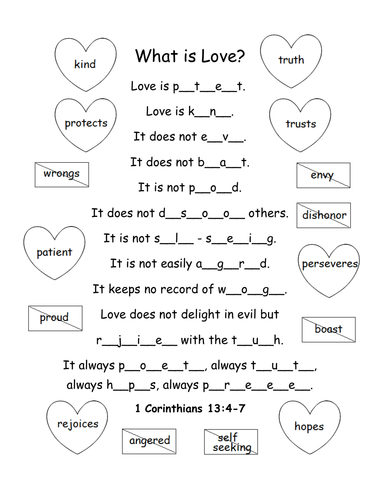
Printable activity/coloring page for 1 Corinthians 13:4-7. What is love? Fill in the blank letters for each word to complete the bible verse.
Love is patient, love is kind. It does not envy, it does not boast, it is not proud. It does not dishonor others, it is not self-seeking, it is not easily angered, it keeps no record of wrongs. Love does not delight in evil but rejoices with the truth. It always protects, always trusts, always hopes, always perseveres.
1 Corinthians 13:4-7 (NIV)
Thank you so much! God bless!
Introduce your learners to Bulgaria in Europe with two printable worksheets (plus answer key). Your students will read a brief introduction to Bulgaria (location, capital, flag, language), write ‘Sofia’ next to the star on the map to show the location of the capital, color the small map and flag, and use the map and compass to answer 6 questions on page 2. Colored pencils and a pen or pencil are needed for this activity. No other prep needed. Basic Geography worksheet with a simple map to introduce Bulgaria and practice cardinal and ordinal directions.
For use with Interactive Notebooks: After completing the worksheets, students can cut out the map and flag and paste into the notebook under the topic of Europe/Sub-Topic: Bulgaria. Under the map and flag, students can write a summary in their own words of what they now know about this country. Collect worksheets for other countries of Europe to add to the notebook! All available in this store! Please browse this store for a selection of worksheets for other countries of Europe (and beyond!)
Thank you so much for using my Geography worksheets in your classroom. I hope you find them useful. Reviews are welcome and very much appreciated!
Included: North Macedonia, Greece, Turkey, Romania, Serbia, Black Sea, Aegean Sea, Sea of Marmara
Introduce your students to the country of SOUTH AFRICA with two worksheets (plus answer key). Your students will read a brief introduction to South Africa (location, capitals, flag, language), write ‘Pretoria’ next to the ‘A’ on the map to show the administrative capital; write ‘Bloemfontein’ next to the ‘J’ to show the judicial capital; write ‘Cape Town’ next to the ‘L’ on the map to show the legislative capital, color the small map, and use the map and compass to answer 9 questions on page 2. Basic Geography Worksheet with a simple map to introduce South Africa and practice cardinal and ordinal directions. Colored pencils and a pen or pencil are needed for this activity.
For use with Interactive Notebooks: After the worksheets are completed, students can cut out the map and flag and paste into the notebook under the topic of Africa / Sub-Topic: South Africa. Under the map, students can write a summary in their own words of what they now know about this country. Collect worksheets for other countries of Africa to add to the notebook! Please browse this store for a selection of worksheets for other countries of Africa (and beyond!).
Thank you so much for using my Geography worksheets in your classroom! I hope you find them useful. Reviews are welcome and very much appreciated.
Introduce your students to ISRAEL with this printable handout of two worksheets (plus answer key). Your students will read a brief introduction to Israel (location, capital, flag, language), write ‘Jerusalem’ next to the star on the map to show the location of the capital, color the small map, and use the map and compass to answer 9 questions on page 2. Colored pencils and a pen or pencil are needed for this activity. No other prep needed. Basic Geography worksheet with a simple map to introduce Israel and practice cardinal/ordinal directions.
For use with Interactive Notebooks: After the worksheets are completed, students can cut out the map and flag and paste into the notebook under the topic of Asia / Sub-topic: Israel. Under the map and flag, your students can write a summary in their own words of what they now know about Israel. Collect handouts for other countries of Asia to add to the notebook! Please browse this store for a selection of worksheets for all other countries of Asia (and beyond)!
Thank you so much for using my Geography worksheets in your classroom! I hope you find them useful. Reviews are welcome and very much appreciated.
Included: Mediterranean Sea, Red Sea, Dead Sea, Holy Land, Lebanon, Syria, Jordan, Egypt, Saudi Arabia, Tel Aviv, Bethlehem, Nazareth, Palestinian territories West Bank and Gaza, Star of David, Tallit.
Introduce your students to Uganda with two worksheets (plus answer key). Your students will read a brief introduction to Uganda (location, capital, flag, language), write ‘Kampala’ next to the star on the map to show the location of the capital, color the small map, and use the map and compass to answer 8 questions on page 2. Colored pencils and a pen or pencil are needed for this activity. No other prep needed. Basic Geography worksheet with a simple map to introduce the country of Uganda and practice cardinal/ordinal directions.
For use with Interactive Notebooks: After the worksheets are completed, students can cut out the map and flag and paste into the notebook under the topic of Africa / Sub-topic: Uganda. Under the map and flag, your students can write a summary in their own words of what they now know about this country. Collect worksheets for other countries of Africa to add to the notebook! Please browse this store for a selection of worksheets for other countries of Africa (and beyond!).
Thank you so much for using my Geography worksheets in your classroom! I hope you find them useful. Reviews are welcome and very much appreciated!
Introduce your students to the country of Andorra with this printable handout of two worksheets (plus answer key). Your students will read a brief introduction to Andorra (location, capital, flag, language), write ‘Andorra la Vella’ next to the star on the map to show the location of the capital, color the small map, and use the map and compass to answer 7 multiple-choice questions on page 2. Colored pencils and a pen or pencil are needed for this activity. No other prep needed. Basic Geography worksheet with a simple map to introduce Andorra and practice cardinal and ordinal directions. Reading comprehension strategies.
For use with Interactive Notebooks: After the worksheets are completed, students can cut out the map and flag and paste into the notebook under the topic of Europe / Sub-Topic: Andorra. Under the map and flag, students can write a summary in their own words of what they now know about this country. Collect worksheets for other countries of Europe to add to the notebook! Worksheets for all countries of Europe are available in this store. Please browse this store for a selection of worksheets for other countries of Europe (and beyond!).
Thank you so much for using my Geography worksheets in your classroom! I hope you find them useful. Reviews are welcome and very much appreciated!