I'm a teacher and the Author of the Amazon e-book;' Time Smart Teaching' and my mission is to create Geography resources to help teachers save time and reduce their workload. I am sharing additional time saving tips for teachers on my YOUTUBE channel ' Time Smart Teaching' if you fancy dropping by!
I'm a teacher and the Author of the Amazon e-book;' Time Smart Teaching' and my mission is to create Geography resources to help teachers save time and reduce their workload. I am sharing additional time saving tips for teachers on my YOUTUBE channel ' Time Smart Teaching' if you fancy dropping by!
This is a table designed to compare all major aspects of your chosen human/ physical fieldwork for GCSE Geography. Written specifically for AQA specification and filled in with examples from Urban regeneration and a coastal long-shore drift investigation, it can easily be adapted to suit your needs. Great revision tool for the paper 3 examination.
A full lesson which can be done with internet research or with textbooks/ revision guides. Student are introduced to a range of landforms and must summarise their formation onto a worksheet grid with links to relevant sites. A detailed annotation task of sand-dunes is included.
Monitoring Climate Change in the Oceans - Geo-stationary Satellites Lesson for Year 9
A full lesson looking at how geo-stationary satelites are used to monitor the impact of climate change in our oceans and a worksheet with questions linked to an article on GIS technology within the NOAA (National Oceanic and Atmospheric Administration).
Description:
Dive into the world of climate change monitoring with our comprehensive lesson on the utilization of geo-stationary satellites. Tailored for year 9 students, this resource offers an in-depth exploration of how these satellites play a pivotal role in understanding and tracking the impact of climate change in our oceans.
Key Features:
Cutting-Edge Technology: Uncover the advanced capabilities of geo-stationary satellites in monitoring climate change, specifically focusing on their application in oceanic studies.
Interactive Learning: Engage students with a well-crafted worksheet, featuring questions linked to an article on GIS technology within the NOAA (National Oceanic and Atmospheric Administration).
Literacy and Reading skills developed. DART activity designed to get students reading and understanding the text.
Adaptable for Higher Ability KS3 Classes: While designed for year 9, the lesson is versatile and can be effectively used with higher-ability KS3 classes.
Why Choose This Resource?
Real-World Application: Connect classroom learning to real-world scenarios by exploring the practical applications of geo-stationary satellites in climate change research.
Critical Thinking: Develop critical thinking skills through the worksheet, encouraging students to analyze and comprehend GIS technology within the NOAA.
Adaptability: Suited for various class levels, ensuring an inclusive learning experience for both year 9 students and higher ability KS3 classes.
Ideal for:
Geography teachers aiming to integrate current technology and climate change into their lessons.
Educators seeking a resource that aligns with year 9 curriculum objectives and challenges higher-ability KS3 students.
Enhance your geography class with this insightful lesson on geo-stationary satellites and GIS technology. Download now to empower your students with knowledge about climate change monitoring in our oceans!
A step-by step guide to help students describe numerical data sets in geography, a core skill for the paper 3 examination in AQA GCSE. Students practise applying this skills to 2 examination type questions with answers provided, linked to Chile earthquake aftershock data.
A good worksheet aimed at exam skills of photo annotation ( of a an arch and a bay) and describing a UK named coastline. Students refer to processes of erosion and deposition to explain the formation of landforms along the Dorset/ Swanage Bay area, which is an ‘example’ needed for the Paper 2 examination for AQA . Students then complete a gap fill exercise to answer a 6 mark examination question; '“Describe the human and physical features of a UK coastline you have studied ( 6 marks).
A versatile and very popular A3 knowelge organiser based on all aspects of enquiry for the human fieldwork element of the AQA specification A curriculum. This is designed on the investigation of the regeneration process in Salford Quays. Completed model-copies can be displayed as a learning tool poster within the classroom. It’s a great way to summarise all their revision in one place.
A literacy based starter activity to get students to understand the benefits of debt relief for NEE’s and LIC’s. A link is provided to the relevant news article in question. Higher ability challenge question included. Directly linked to AQA specification A curriculum for ’ Changing Economic World.’
A greater revision or starter resource to recap on the meanings of keywords from the AQA specification A GCSE curriculum. Students must select the odd word out from sets of 4 to identify differences between types of aid, causes of inequality etc. Answers/ justifications are also provided. Great revision tool for the paper 2 examination. Keywords could also be cut out and used in a ‘pass- the parcel’ revision game- this worked well with my year 11’s.
Made for a year 7 Manchester SOW, this promoted numeracy, literacy and independant research skills. Student pick 10 key historical events that shaped Manchester and present them in a timeline format. Help given to ensure students draw accurate and appropiate scales for their work. Can easily be adapted for another named city.
A differentiated main activity to allow students to find important places within the city of Manchester using an OS map. Could easily be adapted to other cities. Good for a range of abilities and incorporates 4 and figure grid references and extention task for independant work of more able using online Bing maps GIS free website.
Ks3 full lesson written for year 7 ‘Manchester’ themes scheme of work, aimed at deepening their understanding of the city and how football supports the local economy. includes literacy skills through report reading, and a fun starter game where students move around the room to test their understanding on local football teams. Differentiated main activity for low ability students.
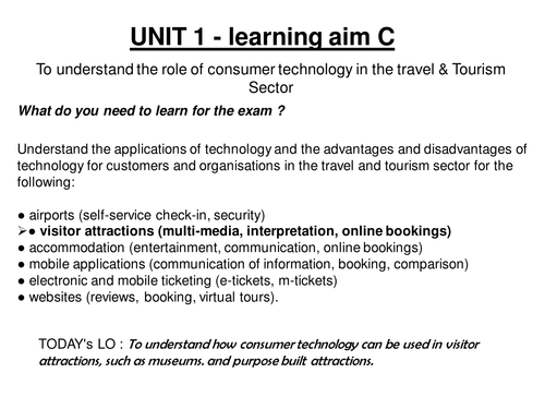
This lesson is part of the examination assessed unit 1 2013 onwards specification. It covers the role of consumer technologies ; multimedia and online booking systems and their advantages and disadvantages for consumers and businesses. There is so very little out there on this that I hope someone else may benefit from my hours of preparation!
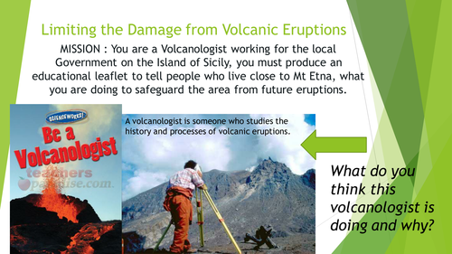
2 lessons on the eruptions of Mt Etna, focusing on the 1992 eruption. Lesson 1 examines the structure of a composite volcano and looks at the impacts of the eruption. Lesson 2 is about diaster planning for volcanic eruptions, specifically for this volcano.
This was done as part of my new Italy topic, and includes differentiated material. Specifically created for yr 8, but easily could be done with year 7. Lesson 2 needs Geog.1 books but it is not essential and could be substituded.
Differentiated resource to allow students to show what they know about the causes effects and solutions to climate change (global warming).\n\nThere is a level assesment criteria and a writing frame to help less able students.\n\nSuitable for years 7 and 8
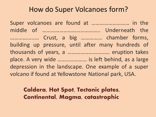
Mercalli scale, Richter scale, Super volcano
Full lesson with a starter recapping on how super volcanoes form (close passage/ gap fill) then moves on to look at how earthquakes are measured. A practical task on classifying earthqake damage by analysing video footage from youtube is included.
Review slides recapping on how the following features are made:ask asks students to work in groups to produce a poster presentation to deliver to the class on one of the features
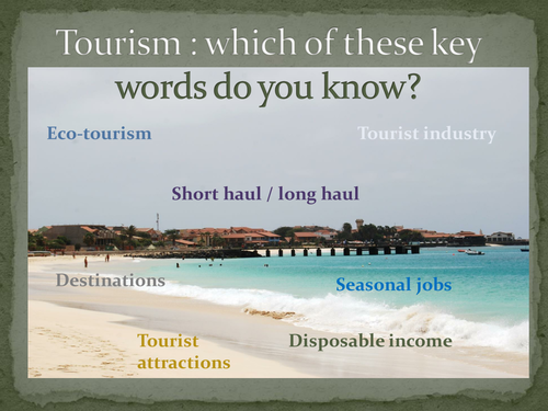
This is a levelled assessment task to review the learning of ks3 students on the topic of Tourism. The existing questions could easily be adapted to suit your scheme of work.
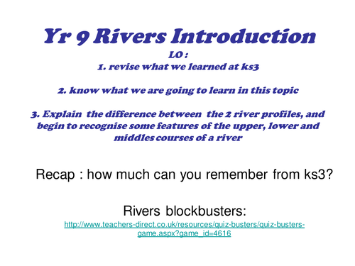
This is a full lesson introducing the water on the land topic. It covers a recap game from KS3, an overview of the course content from exam specification and some activities relating to the long and cross profile of a river. Can be used for other exam boards.
Full lesson looking at the different properties of tectonic boundaries. Students extend and finish the mind map example based on the information provided in the powerpoint.